Organ Pipe Cactus National Monument

Last updated
Organ Pipe Cactus National Monument
IUCN category V (protected landscape/seascape)
Organ Pipe Nat'l Monument - panoramio.jpg
USA Arizona relief location map.svg
Red pog.svg
Usa edcp relief location map.png
Red pog.svg
Location Pima County, Arizona, US
Nearest city Ajo, Arizona
Coordinates 31°57′14″N112°48′04″W / 31.954°N 112.801°W / 31.954; -112.801
Area330,688 acres (1,338.25 km2) [1]
CreatedApril 13, 1937 (1937-April-13)
Visitors260,375(in 2018) [2]
Governing body National Park Service
Website Organ Pipe Cactus National Monument
Short video showing panoramas from Organ Pipe Cactus National Monument

Organ Pipe Cactus National Monument is a U.S. national monument and UNESCO biosphere reserve located in extreme southern Arizona that shares a border with the Mexican state of Sonora. The park is the only place in the United States where the senita and organ pipe cactus grow wild.[ citation needed ] Along with this species, many other types of cacti and other desert flora native to the Yuma Desert section of the Sonoran Desert region grow in the park. Organ Pipe Cactus National Monument is 517 sq mi (1,340 km2) in size. In 1976 the monument was declared a Biosphere Reserve by UNESCO, and in 1977 95% of Organ Pipe Cactus was declared a wilderness area.

Contents

Land for the Monument was donated by the Arizona state legislature to the federal government during Prohibition knowing that the north–south road would be improved and make contraband alcohol easier to import from Mexico.[ citation needed ] In 1937 the land was officially opened as a national monument. [3]

At the north entrance of the park is the unincorporated community of Why, Arizona; the town of Lukeville, Arizona at the park's southern border is a border crossing point to Sonoyta, Sonora, Mexico.

Organ Pipe Cactus National Monument is bordered to the northwest by Cabeza Prieta National Wildlife Refuge and to the east by the Tohono O'odham Indian Reservation. [4]

Mexico-United States barrier

The visitor center has been named in honor of Ranger Kris Eggle. On August 9, 2002, he was shot and killed by a drug smuggler during a United States Border Patrol operation. With a continuing, steady flow of immigrants and drug runners from Mexico, the majority of the park was closed in 2003. After being considered the most dangerous national park, the park reopened the backcountry after surveillance towers, vehicle barriers, and pedestrian fences were installed along the border. [5]

The first 30-foot (9.1 m) panels of a new Arizona, US-Mexico border wall were installed in August 2019 on a two-mile (3.2 km) stretch of Organ Pipe Cactus National Monument. It is the first of three projects that will add bollard walls along Southern Arizona's wildlife refuges. [6] [7] [8] The National Park Service issued a report on September 18, 2019, stating that the barrier wall threatens archaeological artifacts representing 16,000 years of human history. [9] The U.S. Customs and Border Protection agency said that five archaeological sites fall within the area that it wishes to construct. [10]

In February 2020, controlled demolition and other construction work was performed within the Roosevelt Reservation. This strip of land along the border is federally controlled. However, many sites within this region are considered sacred by the Tohono O'odham Nation. Important sites include Monument Hill, which is a ceremonial and historic battle site and burial ground; and Quitobaquito Springs, which is a local water source and the site of an annual salt pilgrimage. For this reason, construction was opposed by many locals, including Representative Raúl Grijalva and Tohono O’odham Nation Chairman Ned Norris, Jr., who testified before Congress on the matter. Customs and Border Protection officials maintained that no human remains or artifacts were discovered in the areas where explosives were used, and that Monument Hill was previously disturbed in 2010 when the existing border fence was installed. [11] [12] [13] [14]

Climate

Organ Pipe Cactus National Monument has a hot desert climate (Köppen: BWh) with very hot summers and mild winters.

Climate data for Organ Pipe Cactus National Monument, Arizona, 1991–2020 normals, extremes 1944–present
MonthJanFebMarAprMayJunJulAugSepOctNovDecYear
Record high °F (°C)90
(32)
95
(35)
99
(37)
104
(40)
111
(44)
119
(48)
118
(48)
116
(47)
113
(45)
107
(42)
98
(37)
88
(31)
119
(48)
Mean maximum °F (°C)81.3
(27.4)
84.2
(29.0)
90.8
(32.7)
97.9
(36.6)
103.4
(39.7)
110.1
(43.4)
111.5
(44.2)
110.4
(43.6)
106.9
(41.6)
100.0
(37.8)
89.9
(32.2)
80.2
(26.8)
112.7
(44.8)
Mean daily maximum °F (°C)70.7
(21.5)
73.0
(22.8)
79.2
(26.2)
85.8
(29.9)
93.3
(34.1)
101.8
(38.8)
103.8
(39.9)
103.2
(39.6)
99.1
(37.3)
90.0
(32.2)
78.9
(26.1)
69.9
(21.1)
87.4
(30.8)
Daily mean °F (°C)56.0
(13.3)
57.9
(14.4)
63.3
(17.4)
68.8
(20.4)
76.3
(24.6)
84.8
(29.3)
89.7
(32.1)
89.3
(31.8)
84.5
(29.2)
74.3
(23.5)
63.4
(17.4)
55.4
(13.0)
72.0
(22.2)
Mean daily minimum °F (°C)41.4
(5.2)
42.9
(6.1)
47.3
(8.5)
51.9
(11.1)
59.3
(15.2)
67.8
(19.9)
75.6
(24.2)
75.3
(24.1)
69.9
(21.1)
58.5
(14.7)
47.9
(8.8)
40.9
(4.9)
56.6
(13.7)
Mean minimum °F (°C)29.2
(−1.6)
31.6
(−0.2)
35.9
(2.2)
39.9
(4.4)
48.2
(9.0)
56.4
(13.6)
65.8
(18.8)
66.3
(19.1)
58.8
(14.9)
45.3
(7.4)
35.5
(1.9)
29.3
(−1.5)
26.8
(−2.9)
Record low °F (°C)14
(−10)
18
(−8)
16
(−9)
31
(−1)
30
(−1)
46
(8)
52
(11)
50
(10)
46
(8)
29
(−2)
24
(−4)
18
(−8)
14
(−10)
Average precipitation inches (mm)0.99
(25)
0.89
(23)
0.78
(20)
0.31
(7.9)
0.18
(4.6)
0.11
(2.8)
1.32
(34)
1.82
(46)
0.75
(19)
0.56
(14)
0.44
(11)
1.13
(29)
9.28
(236)
Average precipitation days (≥ 0.01 inch)3.23.73.01.10.60.54.36.03.01.82.14.033.3
Source: NOAA [15] [16]

See also

Related Research Articles

<span class="mw-page-title-main">Tohono Oʼodham</span> Native American people of the Sonoran Desert

The Tohono Oʼodham are a Native American people of the Sonoran Desert, residing primarily in the U.S. state of Arizona and the northern Mexican state of Sonora. The United States federally recognized tribe is the Tohono Oʼodham Nation.

<span class="mw-page-title-main">Pima County, Arizona</span> County in Arizona, United States

Pima County is a county in the south central region of the U.S. state of Arizona. As of the 2020 census, the population was 1,043,433, making it Arizona's second-most populous county. The county seat is Tucson, where most of the population is centered. The county is named after the Pima Native Americans, also known as Tohono O'odham, who are indigenous to this area.

<span class="mw-page-title-main">Ajo, Arizona</span> Community in Pima County, Arizona

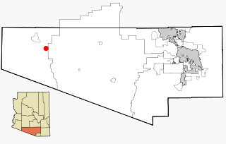
Ajo is an unincorporated community in Pima County, Arizona, United States. It is the closest community to Organ Pipe Cactus National Monument. The population was 3,304 at the 2010 census. Ajo is located on State Route 85 just 43 miles (69 km) from the Mexican border.

<span class="mw-page-title-main">Southwestern United States</span> Geographical region of the United States

The Southwestern United States, also known as the American Southwest or simply the Southwest, is a geographic and cultural region of the United States that includes Arizona and New Mexico, along with adjacent portions of California, Colorado, Nevada, Oklahoma, Texas, and Utah. The largest cities by metropolitan area are Phoenix, Las Vegas, El Paso, Albuquerque, and Tucson. Before 1848, in the historical region of Santa Fe de Nuevo México as well as parts of Alta California and Coahuila y Tejas, settlement was almost non-existent outside of Nuevo México's Pueblos and Spanish or Mexican municipalities. Much of the area had been a part of New Spain and Mexico until the United States acquired the area through the Treaty of Guadalupe Hidalgo in 1848 and the smaller Gadsden Purchase in 1854.

<span class="mw-page-title-main">Sonoran Desert</span> Desert in Mexico and the United States

The Sonoran Desert is a hot desert in North America and ecoregion that covers the northwestern Mexican states of Sonora, Baja California, and Baja California Sur, as well as part of the southwestern United States. It is the hottest desert in both Mexico and the United States. It has an area of 260,000 square kilometers (100,000 sq mi).

<span class="mw-page-title-main">Sonoyta</span> Town in Sonora, Mexico

Sonoyta, Sonora, is a town in the northern Mexican state of Sonora. It stands on the U.S.-Mexico border, facing Lukeville, Arizona, in the United States. It is the municipal seat of the municipality of Plutarco Elías Calles.

<span class="mw-page-title-main">Why, Arizona</span> Unincorporated community in Pima County, Arizona, United States

Why is an unincorporated rural community in Pima County, Arizona, United States. It lies near the western border of the Tohono Oʼodham Indian Reservation and due north of Organ Pipe Cactus National Monument in Southern Arizona. It is approximately 30 miles (48 km) north of the Mexican border where Lukeville, Arizona, and Sonoyta, Sonora, Mexico, border each other, and 10 miles (16 km) south of Ajo, Arizona.

Lukeville is a small unincorporated town on the Mexico–United States border in southern Pima County, Arizona, United States. It was named for World War I aviator Frank Luke, an Arizona native who was awarded a posthumous Medal of Honor.

<span class="mw-page-title-main">Tohono Oʼodham Nation</span> Indian reservation in Tohono Oodham, United States

The Tohono Oʼodham Nation is the collective government body of the Tohono Oʼodham tribe in the United States. The Tohono Oʼodham Nation governs four separate pieces of land with a combined area of 2.8 million acres (11,330 km2), approximately the size of Connecticut and the second largest Indigenous land holding in the United States. These lands are located within the Sonoran Desert of south central Arizona and border the Mexico–United States border for 74 miles (119 km) along its southern border. The Nation is organized into 11 local districts and employs a tripartite system of government. Sells is the Nation's largest community and functions as its capital. The Nation has approximately 34,000 enrolled members, the majority of whom live off of the reservations.

<span class="mw-page-title-main">Saguaro National Park</span> National park in Arizona, United States

Saguaro National Park is a United States national park in Pima County, southeastern Arizona. The 92,000-acre (37,000 ha) park consists of two separate areas—the Tucson Mountain District (TMD), about 10 miles (16 km) west of Tucson, and the Rincon Mountain District (RMD), about 10 miles (16 km) east of the city. Both districts preserve Sonoran Desert landscapes, fauna, and flora, including the giant saguaro cactus.

<span class="mw-page-title-main">Saguaro</span> Species of cactus in the Sonoran Desert

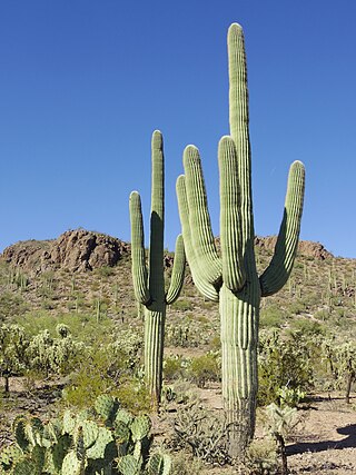
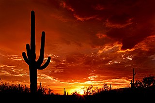
The saguaro is a tree-like cactus species in the monotypic genus Carnegiea that can grow to be over 12 meters tall. It is native to the Sonoran Desert in Arizona, the Mexican state of Sonora, and the Whipple Mountains and Imperial County areas of California. The saguaro blossom is the state wildflower of Arizona. Its scientific name is given in honor of Andrew Carnegie. In 1933, Saguaro National Park, near Tucson, Arizona, was designated to help protect this species and its habitat.

<span class="mw-page-title-main">Bates Well Ranch</span> United States historic place

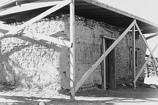
The Bates Well Ranch, also known as the Bates Well, Growler Well, Gray Ranch and El Veit, was one of the fifteen ranches and line camps in the Gray family cattle business in the Sonoran Desert country north of the US-Mexico border in Pima County, Arizona. Operating for nearly 60 years, the ranch is now part of Organ Pipe Cactus National Monument.

<span class="mw-page-title-main">El Pinacate y Gran Desierto de Altar Biosphere Reserve</span> UNESCO biosphere reserve in Sonora, Mexico

El Pinacate and Gran Desierto de Altar Biosphere Reserve is a biosphere reserve and UNESCO World Heritage Site managed by the federal government of Mexico, specifically by Secretariat of the Environment and Natural Resources, in collaboration with the state governments of Sonora and the Tohono O'odham.

Flora of the Sonoran Desert includes six subdivisions based on vegetation types. Two are north of the boundary between the United States and Mexico, and four are south of the boundary. The flora of the Colorado Desert are influenced by the environment of the very dry and hot lower areas of the Colorado River valley, which may be barren, treeless, and generally have no large cacti. Flora of the Arizona Upland are comparatively lush, with trees and large columnar cacti that can withstand winter frosts. Those subdivisions of the Sonoran Desert which lie south of the international border are characterized by plants that cannot withstand frost.

<span class="mw-page-title-main">Gachado Well and Line Camp</span> United States historic place

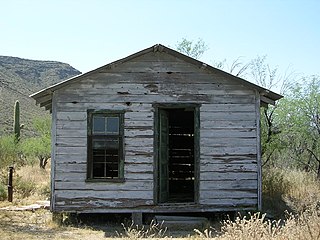
The Gachado Well was excavated between 1917 and 1919 near the Arizona-Mexico border in Pima County, Arizona. Named after a stooped mesquite tree, the well served a ranch owned by Lonald Blankenship. The line camp and water rights were sold in 1919 to Robert Louis Gray, who built an adobe house at the site in 1930. The house became a line camp, a bunkhouse for cowboys on the range in that area. The camp was used until 1976, when the Grays discontinued ranching. The site is located within Organ Pipe Cactus National Monument. It is accessible via the rough, unpaved Camino de Dos Republicas, which also leads to Dos Lomitas Ranch, another Gray family property.

The Arizona borderlands are the geographic and cultural region north of the Arizona portion of the US-Mexico border. The area is unique in that it features both an international border and the Tohono O'oham sovereign nation along much of that border. Frequent and persistent topics of interest in the area include the presence of illegal immigration, the confluence of local, state, and national politics surrounding the border, conservation and sustainable living, and the presence of drug traffickers and paramilitary forces in the vicinity.

<span class="mw-page-title-main">Quitobaquito Springs</span> Waterbody in Pima County, Arizona

Quitobaquito Springs are springs in Organ Pipe Cactus National Monument in Pima County, Arizona. The name is of Tohono O'odham origin meaning 'house ring spring'. The area has been populated for at least 16,000 years. It lies at an elevation of 1,152 feet (351 m), west of the south end of the Quitobaquito Hills, along the border of the United States with Mexico. The only US populations of the endangered Quitobaquito pupfish, the Sonoyta mud turtle, the desert caper, and the Howarth's white butterfly are found here. The Quitabaquito tryonia is an endemic resident of the springs.

Quitobaquito Hills is a range of hills in Pima County, Arizona. The name is of Tohono O'odham - Spanish origin meaning 'house ring spring'. Its tallest summit is an unnamed hill 1,880 feet that overlooks Cipriano Pass to the east. The range trends northwest from near the Mexican border at 31°56′24″N113°00′47″W, east of Quitobaquito Springs northwestward out of the Organ Pipe Cactus National Monument to the tallest summit then turns westward to the vicinity of 31°59′55″N113°06′12″W, south of the eastern end of the Agua Dulce Mountains.

Several Indigenous peoples who live on the United States–Mexico border have objected to the construction of a border wall on their territories and the militarization of the border by the United States government. The US–Mexico border crosses several Indigenous territories and divides these communities. The barrier erected between the United States and Mexico cuts through and/or affects at least 29 Indigenous tribes, which include Kumeyaay Nation and Tohono O'odham.

The Growler Mine Area is a historic mine located in Organ Pipe Cactus National Monument west of the Bates Well Ranch.

References

  1. "Listing of acreage – December 31, 2011" (XLSX). Land Resource Division, National Park Service. Retrieved 2012-05-14. (National Park Service Acreage Reports)
  2. "NPS Annual Recreation Visits Report". National Park Service. Retrieved 2019-06-15.
  3. "Listing of National Park System Areas by State". National Park Service. Retrieved 2011-06-30.
  4. Brean, Henry (August 15, 2019). "Trump administration delays border wall work in Arizona preserves". Arizona Daily Star. Retrieved August 15, 2019.
  5. Peterson, Jodi (2014-09-17). "After 11 years, Organ Pipe Cactus National Monument reopens". High Country News. Retrieved 2020-11-07.
  6. Smith, Dylan; Ingram, Paul (August 25, 2019). "New border wall going up in Arizona's Organ Pipe National Monument". Tucson Sentinel. Tucson, Arizona. Retrieved August 28, 2019.
  7. Carranza, Rafael (August 23, 2019). "Trump administration begins to replace existing border barriers in Arizona using military funds". The Arizona Republic . Retrieved August 28, 2019 via AZCentral.
  8. Prendergast, Curt (September 1, 2019). "Border wall rising near Lukeville". Arizona Daily Star. Retrieved 2019-09-02.
  9. Burnett, John (October 11, 2019). "Border Wall Construction In Arizona Bulldozes Cactus Columns". NPR News. Retrieved 2020-11-07.
  10. Da Silva, Chantal (Sep 18, 2019). "Donald Trump's border wall could see 16,000 years of history destroyed, National Park Service report warns". Newsweek.
  11. Devereaux, Ryan (2020-02-06). "Trump Is Blowing Up a National Monument in Arizona to Make Way for the Border Wall". The Intercept. Retrieved 2020-02-07.
  12. Prendergast, Curt (February 8, 2020). "Crews blasting hill in Organ Pipe monument to make way for border wall". Arizona Daily Star. Retrieved 2020-02-07.
  13. Prendergast, Kurt (February 27, 2020). "Border Patrol offers view of blasting for wall on Organ Pipe National Monument". Arizona Daily Star. Retrieved March 27, 2020.
  14. Hsieh, Steven (2020-02-27). "Tohono O'odham Chairman to Congress: Trump's Wall Is Destroying Tribal Sites". Phoenix New Times. Retrieved 2020-07-23.
  15. "NOWData - NOAA Online Weather Data". National Oceanic and Atmospheric Administration. Retrieved December 14, 2022.
  16. "Summary of Monthly Normals 1991-2020". National Oceanic and Atmospheric Administration. Retrieved December 15, 2022.