
The Sonoran Desert is a North American desert and ecoregion that covers large parts of the southwestern United States, as well as the northwestern Mexican states of Sonora, Baja California, and Baja California Sur. It is the hottest desert in both Mexico and the United States. It has an area of 260,000 square kilometers (100,000 sq mi).

Organ Pipe Cactus National Monument is a U.S. national monument and UNESCO biosphere reserve located in extreme southern Arizona that shares a border with the Mexican state of Sonora. The park is the only place in the United States where the senita and organ pipe cactus grow wild. Along with this species, many other types of cacti and other desert flora native to the Yuma Desert section of the Sonoran Desert region grow in the park. Organ Pipe Cactus National Monument is 517 sq mi (1,340 km2) in size. In 1976 the monument was declared a Biosphere Reserve by UNESCO, and in 1977 95% of Organ Pipe Cactus was declared a wilderness area.

Pipe Spring National Monument is a United States National Monument located in the U.S. state of Arizona, rich with American Indian, early explorer, and Mormon pioneer history. Administered by the National Park Service, Pipe Spring was listed on the National Register of Historic Places on October 15, 1966, and the boundaries of the Pipe Spring National Monument Historic District were expanded in October 2000.

Pecos National Historical Park is a United States National Historical Park in San Miguel and Santa Fe Counties, New Mexico. The park, operated by the National Park Service, encompasses thousands of acres of landscape infused with historical elements from prehistoric archaeological ruins to 19th-century ranches, to a battlefield of the American Civil War. Its largest single feature is Pecos Pueblo also known as Cicuye Pueblo, a Native American community abandoned in historic times. First a state monument in 1935, it was made Pecos National Monument in 1965, and greatly enlarged and renamed in 1990. Two sites within the park, the pueblo and the Glorieta Pass Battlefield, are National Historic Landmarks.

Stenocereus thurberi, the organ pipe cactus, is a species of cactus native to Mexico and the United States. The species is found in rocky desert. Two subspecies are recognized based on their distribution and height. The Organ Pipe Cactus National Monument is named for the species.

Rancho Petaluma Adobe is a historic ranch house in Sonoma County, California. It was built from adobe bricks in 1836 by order of Mariano Guadalupe Vallejo. It was the largest privately owned adobe structure built in California and is the largest example of the Monterey Colonial style of architecture in the United States. A section of the former ranch has been preserved by the Petaluma Adobe State Historic Park and it is both a California Historic Landmark and a National Historic Landmark. The Rancho Petaluma Adobe State Historic Park is located on Adobe Road on the east side of the present-day town of Petaluma, California.

Mission San Cayetano de Calabazas, also known as Calabasas, is a Spanish Mission in the Sonoran Desert, located near present-day Tumacacori, Arizona, United States. The Mission was named for the Italian Saint Cajetan.
The Miller Brothers 101 Ranch was a 110,000-acre (45,000 ha) cattle ranch in the Indian Territory of Oklahoma before statehood. Located near modern-day Ponca City, it was founded by Colonel George Washington Miller, a veteran of the Confederate Army, in 1893. The 101 Ranch was the birthplace of the 101 Ranch Wild West Show and one of the early focal points of the oil rush in northeastern Oklahoma. It was the largest diversified farm and ranch in America at the time. Bill Pickett's grave and the White Eagle Monument are located on the ranch grounds. The location of the former working cattle ranch was subdivided and all of its buildings destroyed. An 82-acre (33 ha) area of the ranch is a National Historic Landmark. In 2003, the ranch was inducted into the Texas Trail of Fame.

Warner's Ranch, near Warner Springs, California, was notable as a way station for large numbers of emigrants on the Southern Emigrant Trail from 1849 to 1861, as it was a stop on both the Gila River Trail and the Butterfield Overland Mail stagecoach line (1859-1861). It was also operated as a pioneering cattle ranch.
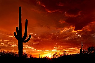
Saguaro National Park is an American national park in Pima County, southeastern Arizona. The 92,000-acre (37,000 ha) park consists of two separate areas—the Tucson Mountain District (TMD) about 10 miles (16 km) west of the city of Tucson and the Rincon Mountain District (RMD) about 10 miles (16 km) east of the city—that preserve Sonoran Desert landscapes, fauna, and flora, including the giant saguaro cactus.

The Keys Ranch is the prime example of early settlement in the Joshua Tree National Park area. Bill Keys was the area's leading character, and his ranch is a symbol of the resourcefulness of early settlers. The ranch is an extensive complex of small frame buildings built between 1910 and Keys' death in 1964. Keys pursued both ranching and mining to make a living in the desert.

The Faraway Ranch Historic District is part of the Chiricahua National Monument in southeastern Arizona, and preserves an area associated with the final conflicts with the local Apache, one of the last frontier settlements, and in particular, its association with the people who promoted the establishment of the Chiricahua National Monument. Faraway Ranch is located in Bonita Canyon, which lies at an approximate altitude of 5160 feet and opens in a southwesterly direction into the Sulphur Springs Valley.
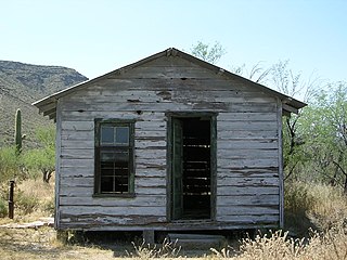
The Bates Well Ranch, also known as the Bates Well, Growler Well, Gray Ranch and El Veit, was one of the fifteen ranches and line camps in the Gray family cattle business in the Sonoran Desert country north of the US-Mexico border in Pima County, Arizona. Operating for nearly 60 years, the ranch is now part of Organ Pipe Cactus National Monument.

The Barton–Lackey Cabin, also known as the Barton Cattle Camp and the Lackey Cattle Camp, was built in 1910 in the Roaring River Canyon of what became Kings Canyon National Park in California. The cabin was a shelter for stockmen using the summer range in the upper Kings River Canyon summer range, at an elevation of 7400 feet. The cabin was once surrounded by a significant number of outbuildings, which have all disappeared.

The James Cant Ranch is a pioneer ranch complex in Grant County in eastern Oregon, United States. The ranch is located on both sides of the John Day River in the John Day Fossil Beds National Monument. The ranch was originally homesteaded by Floyd Officer in 1890. Officer sold the property to James Cant in 1910. Cant increased the size of the property and built a modern ranch complex on the west bank of the river. The National Park Service bought the ranch from the Cant family in 1975, and incorporated the property into the John Day Fossil Beds National Monument. The National Park Service used the main house as a visitor center until 2003. Today, the Cant Ranch complex is preserved as an interpretive site showing visitors an early 20th-century livestock ranch. The James Cant Ranch is listed on the National Register of Historic Places.

The historical buildings and structures of Grand Teton National Park include a variety of buildings and built remains that pre-date the establishment of Grand Teton National Park, together with facilities built by the National Park Service to serve park visitors. Many of these places and structures have been placed on the National Register of Historic Places. The pre-Park Service structures include homestead cabins from the earliest settlement of Jackson Hole, working ranches that once covered the valley floor, and dude ranches or guest ranches that catered to the tourist trade that grew up in the 1920s and 1930s, before the park was expanded to encompass nearly all of Jackson Hole. Many of these were incorporated into the park to serve as Park Service personnel housing, or were razed to restore the landscape to a natural appearance. Others continued to function as inholdings under a life estate in which their former owners could continue to use and occupy the property until their death. Other buildings, built in the mountains after the initial establishment of the park in 1929, or in the valley after the park was expanded in 1950, were built by the Park Service to serve park visitors, frequently employing the National Park Service Rustic style of design.
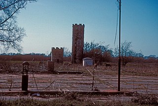
This is a list of the National Register of Historic Places listings in Organ Pipe Cactus National Monument.

The Knight Block is a historic building located on South University Avenue in downtown Provo, Utah, United States. It is listed on the National Register of Historic Places.
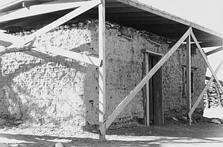
The Gachado Well was excavated between 1917 and 1919 near the Arizona-Mexico border in Pima County, Arizona. Named after a stooped mesquite tree, the well served a ranch owned by Lonald Blankenship. The line camp and water rights were sold in 1919 to Robert Louis Gray, who built an adobe house at the site in 1930. The house became a line camp, a bunkhouse for cowboys on the range in that area. The camp was used until 1976, when the Grays discontinued ranching. The site is located within Organ Pipe Cactus National Monument. It is accessible via the rough, unpaved Camino de Dos Republicas, which also leads to Dos Lomitas Ranch, another Gray family property.


