Fossil Creek

Last updated

Fossil Creek
Waterfall Trail on Fossil Creek (30064915386).jpg
Waterfall on Fossil Creek
Fossil Creek proposal map.png
Fossil Creek proposal map (March 2011)
USA Arizona relief location map.svg
Red pog.svg
Location of the mouth of
Fossil Creek at the Verde River
Etymologythe resemblance to fossils of the stream's rocks and vegetation, coated with travertine [1]
Native nameHakhavsuwa (Yavapai)
Location
Country United States
State Arizona
County Coconino, Yavapai, Gila
City Strawberry
Physical characteristics
Source 
  coordinates 34°26′07″N111°30′31″W / 34.43528°N 111.50861°W / 34.43528; -111.50861 [2]
  elevation6,510 ft (1,980 m) [3]
Mouth Verde River
  coordinates
34°18′21″N111°40′32″W / 34.30583°N 111.67556°W / 34.30583; -111.67556 [2]
  elevation
2,543 ft (775 m) [2]
Length17 mi (27 km) [4] [5]
Basin size135 sq mi (350 km2) [4]
Discharge 
  location Fossil Creek Bridge [n 1]
  average43 cu ft/s (1.2 m3/s) [n 2]
  minimum39 cu ft/s (1.1 m3/s)
  maximum885 cu ft/s (25.1 m3/s)
TypeWild, Recreational
DesignatedMarch 30, 2009

Fossil Creek (Yavapai : Hakhavsuwa or Vialnyucha) is a perennial stream accessed by forest roads near the community of Camp Verde in the U.S. state of Arizona. Primary access is from Forest Road 708 off Arizona State Route 260 east of Camp Verde. A tributary of the Verde River, Fossil Creek flows from its headwaters on the Mogollon Rim to meet the larger stream near the former Childs Power Plant.

Contents

Fossil Springs, near the headwaters, emits upwards of 20,000 US gallons (76 m3) per minute that flow into the creek year-round. Calcium carbonate, precipitating from the 72 °F (22 °C) water from the springs, creates travertine dams and deposits for several miles downstream. The Fossil Creek system is the fourth largest producer of travertine in the United States.

Fossil Creek is one of only two streams in Arizona included in the National Wild and Scenic Rivers System. The creek and its riparian corridor provide habitat for a wide variety of flora and fauna, some listed as endangered or otherwise imperiled. Its former power-plant complex is listed as a National Historic District. Since restoration of the stream's natural flow in 2008, an increase in recreational visits has raised concerns about overuse and has led to road closings and other restrictions.

Course

Fossil Springs, the head water of Fossil Creek, arises at an elevation of 6,510 feet (1,980 m) above sea level on the Mogollon Rim in Coconino County north of Strawberry. [2] For about the first 3 miles (5 km), the creek's flow is intermittent. [5]

From high on the rim, the creek runs generally north, entering Gila County almost immediately. It continues north through the wilderness to the confluence of an intermittent stream in Calf Pen Canyon, which enters from the right. [5] Turning west, the creek receives another intermittent stream from the right in Sandrock Canyon, at the head of Fossil Creek Canyon. Before it reaches Fossil Springs, the creek becomes the boundary between Gila County on the stream's left and Yavapai County on its right, and it remains the boundary all the way to the Verde River. [5]

The perennial stretches of the stream begin at Fossil Springs, at river mile (RM) 14 or river kilometer (RK) 23, in the Fossil Springs Wilderness of the Coconino National Forest at an elevation of about 4,100 feet (1,200 m). [4] Below the springs, the creek flows west and southwest, passing the remnants of a former dam. Unnamed intermittent streams enter from left and right. Before Fossil Creek reaches the former Irving Power Plant, it leaves the Fossil Springs Wilderness, and below the plant, it enters the Mazatzal Wilderness of the Tonto National Forest. [5] Forest Road 708 (Fossil Creek Road) follows the creek for 2.5 miles (4.0 km) along this stretch, [4] crossing the creek once at Fossil Creek Bridge. [8]

After Cimarron Creek Wash enters from the right, Fossil Creek turns sharply south. In the next stretch, Stehr Lake is to the right and Deadman Mesa to the left. Hardscrabble Creek enters from the left just before Fossil Creek turns west again and enters the Verde River. [5]

Discharge

The flow of water from Fossil Springs has been estimated to range from 43 to 56 cubic feet per second (1.2 to 1.6 m3/s) (320–420 gal/s) year-round, and it emerges from underground at a constant 72 °F (22 °C). [4] The United States Geological Survey installed a stream gauge at the Fossil Creek Bridge in 2010. The maximum daily discharge at that station was 885 cubic feet per second (25.1 m3/s) on February 19, 2011, and the minimum was 39 cubic feet per second (1.1 m3/s) on August 6, 2011. [6]

Geology

Fossil Creek Canyon is about 1,600 feet (490 m) deep and varies in width from 2 miles (3 km) at Fossil Springs to less than 1 mile (1.6 km) in places further downstream. [9] Rocks in the canyon vary in age from the Precambrian through the Cenozoic. [4] North of the springs the canyon cuts through Paleozoic sedimentary rocks including the Redwall Limestone, Naco Group, Supai Group, Schnebly Hill Formation, Coconino Sandstone, and Kaibab Formation. [10] South of the springs, the rocks of the canyon are Tertiary volcanics, mostly dark-gray basalt and yellow-gray tuff. [10]

Fossil Creek Canyon, viewed from road to Strawberry in 2010 Fossil Creek Canyon, AZ.jpg
Fossil Creek Canyon, viewed from road to Strawberry in 2010

Fossil Springs, the source of about 80 percent of the water in Fossil Creek, issues from several vents in close proximity to one another at the base of the Mogollon Rim. [10] The rim is the southern edge of the Colorado Plateau. Water percolating through limestone layers in the rim becomes laden with dissolved carbon dioxide and calcium carbonate. [10] When the water emerges at the springs, it begins to release carbon dioxide as a gas and calcium carbonate as travertine, a porous form of calcite often found around hot springs such as Mammoth Hot Springs in Yellowstone National Park. [11] The release, affected by stream turbulence and other factors, does not occur all at once but continues downstream. [10]

Nineteenth-century observers of the creek reported seeing many naturally occurring travertine dams with deep pools behind them. [10] A study conducted in 1996 identified the eroded remnants of at least 80 such dams. [10] After the creek's natural flow was restored in 2008, hundreds of new travertine dams began to form along a 6-mile (10 km) stretch below Fossil Springs. [12] About 13 short tons (12 t) of travertine per day are deposited along the stream. [13] This rate of deposition makes Fossil Creek the fourth largest travertine system in the United States; the three larger systems are Mammoth Hot Springs, Havasu Creek, and Blue Springs of the Little Colorado River. [14]

History

Early

Lower Fossil Creek, 2008 Fossil Crk.png
Lower Fossil Creek, 2008

Archaeologists have found evidence of prehistoric use of the Fossil Creek watershed, and it is possible that people lived here as long as 10,000 years ago. [15] More recently, Yavapai and Apache peoples have lived in the area, also used by 19th-century cattlemen and shepherds. [15]

Fossil Creek first appeared on maps in Arizona in the 1860s, when Arizona Territory's first governor, John Noble Goodwin, passed through the region. [16] Members of the Goodwin group noted "petrifactions", travertine-encased rocks and twigs that looked like fossils, hence the name Fossil Creek. [16]

Hydroelectric plants

Few streams in Arizona have a flow as large and steady as Fossil Creek's. [1] Although remote, the stream was seen in the early 20th century as a good place to produce electricity for the copper mines of Jerome and the gold and silver mines of the Bradshaw Mountains. [1] In 1908, construction began on a hydropower plant on the Verde River at Childs under the authority of the Arizona Power Company, later part of the Arizona Public Service Company (APS). [1] The project included creating a diversion dam, 25 feet (7.6 m) high, across the creek. [17] About 8,800 feet (2,700 m) of concrete flumes carried water from the dam to the Childs plant. [1] An artificial reservoir, Stehr Lake, held enough water to keep the plant operating at normal capacity for up to 3.5 days when the flume system was closed for maintenance. [18] In 1916, the company constructed a second plant, the Irving Power Plant, along Fossil Creek. [1]

Childs-Irving was the first hydroelectric power plant built in Arizona, and in 1920 it was supplying as much as 70 percent of the power used by Phoenix. [19] The complex was named an Historic Mechanical Engineering Landmark in 1976 and a National Historic District in 1991. [20]

Stream restoration

In 2004 invasive species were removed from the creek to maximize native fish survival. [21] A fish barrier 5 miles (8 km) from the mouth prevents invasive species from swimming further upstream. [21] In 2005, after assessing costs, the plants' low output, and the goodwill to be generated from stream restoration, APS closed both power plants, and in 2008 APS removed the diversion dam. [17]

In 2009 President Barack Obama signed legislation designating Fossil Creek as a National Wild and Scenic River, after a long campaign by the Arizona Nature Conservancy. [22] The legislation, passed by Congress, protects 16.8 miles (27.0 km) of stream. The 2.7-mile (4.3 km) segment from the confluence of Sand Rock and Calf Pen canyons to where the stream leaves the Fossil Spring Wilderness is "wild". The 7.5-mile (12.1 km) stretch from there to the Mazatzal Wilderness boundary is "recreational", and the remaining 6.6 miles (10.6 km) of the stream is "wild". [23] Fossil Creek is one of only two streams in Arizona with Wild and Scenic segments; the other is the Verde River. [24]

Fauna and flora

Chiricahua leopard frog, a threatened species found in the Fossil Creek watershed Chiricahua leopard frog 01.jpg
Chiricahua leopard frog, a threatened species found in the Fossil Creek watershed

The creek and its riparian zone support about 200 species of birds, mammals, reptiles, and amphibians. The list includes many special-status species such as the southwestern willow flycatcher and Chiricahua leopard frog. [25] The watershed supports 27 species of neotropical migratory birds such as the sage sparrow and 20 species such as the common black hawk that are rated sensitive by the U.S. Forest Service. [25] Mammals found in or near Fossil Creek include otter and beaver, Merriam's shrew, a variety of bats, and other species. Among the reptiles and amphibians are the Arizona toad, and the reticulated Gila monster. [25]

Native fish in Fossil Creek include headwater chub, roundtail chub, speckled dace, longfin dace, Sonora sucker, and desert sucker. [26] Between 2007 and 2010, the Arizona Game and Fish Department and the U.S. Fish and Wildlife Service added native spikedace, loach minnows, Gila topminnows, and razorback suckers as well as more longfin dace above the barrier. All except speckled dace are special-status fish listed as endangered, threatened, or sensitive by federal or state agencies. In addition, more than 100 macroinvertebrate species live in the Fossil Creek watershed. [26] One, the fossil springsnail, is listed sensitive by the U.S. Forest Service. [26]

Fossil Creek's riparian zones provide high-quality habitat for plant species native to the area. These include deciduous trees such as the Arizona alder and Fremont cottonwood as well as a wide variety of shrubs, grasses, ferns, and other understory plants. [27] Species diversity is higher above the site of the former power-plant dam, especially near Fossil Springs. In 1987, a 26-acre (11 ha) plot above the dam was set aside as the Fossil Springs Botanical Area. [27] Plant inventories taken between 2003 and 2005 identified 166 plant species in the botanical area and 314 species of flowering plants and ferns in the larger Fossil Creek area. [27]

Recreation

Fossil Creek's steady flow, warmth, deep pools, and small waterfalls attract visitors who wade, swim, float, kayak, and snorkel in its waters. Four named hiking paths intersect the Fossil Creek corridor: the Flume–Irving, Fossil Springs, Mail, and Deadman Mesa trails. [28] The U.S. Forest Service allows dispersed camping in some parts of the area but has made other parts, such as riparian zones, off-limits to overnight stays. Other activities in the area include wildlife viewing, photography, fishing, and visits to the remains of the Childs-Irving infrastructure. [28]

Restoring the stream has made the area, a two-hour drive from Phoenix, highly popular. As recreational use of Fossil Creek increased after 2008, accumulations of trash and human waste as well as damage to forests and stream banks became problematic. [13] [17] Primary access is from Forest Road 708 (Fossil Creek Road) off Arizona State Route 260 east of Camp Verde, which is 22 miles (35 km) by paved highway and unpaved road from the creek. The Forest Service at times closes parts of Forest Road 708 because of weather, health, and safety concerns. [29] Campfires are prohibited between the Fossil Creek headwaters and the dry bed of Stehr Lake, and other restrictions apply. [8] From April 1 to October 1, vehicle parking at Fossil Creek is available only by advanced permit, available a month ahead of time via the Recreation.gov website. [30] Since 2009, the Forest Service has been working on a comprehensive management plan for Fossil Creek. [31]

See also

Notes and references

Notes

  1. The stream gauge at Fossil Creek Bridge was installed in September 2010. Before that, the creek was never gauged, although the flume was gauged and the Verde River was gauged at Tangle Creek, below the mouth of Fossil Creek. The average discharge of 43 cubic feet per second (1.2 m3/s) cited here represents the base flow emanating from Fossil Springs. The maximum and minimum flows were measured at the bridge in 2010 and 2011. [6] [7]
  2. The stream gauge at Fossil Creek Bridge was installed in September 2010. Before that, the creek was never gauged, although the flume was gauged and the Verde River was gauged at Tangle Creek, below the mouth of Fossil Creek. The average discharge of 43 cubic feet per second (1.2 m3/s) cited here represents the base flow emanating from Fossil Springs. The maximum and minimum flows were measured at the bridge in 2010 and 2011. [6] [7]

Related Research Articles

<span class="mw-page-title-main">Salt River (Arizona)</span> River in Gila and Maricopa counties in Arizona, United States

The Salt River is a river in Gila and Maricopa counties in Arizona, United States, that is the largest tributary of the Gila River. The river is about 200 miles (320 km) long. Its drainage basin covers about 13,700 square miles (35,000 km2). The longest of the Salt River's many tributaries is the 195-mile (314 km) Verde River. The Salt's headwaters tributaries, the Black River and East Fork, increase the river's total length to about 300 miles (480 km). The name Salt River comes from the river's course over large salt deposits shortly after the merging of the White and Black Rivers.

<span class="mw-page-title-main">Salmon River (Idaho)</span> River in Idaho, United States

The Salmon River, also known as "The River of No Return", is a river located in the U.S. state of Idaho in the western United States. It flows for 425 miles (685 km) through central Idaho, draining a rugged, thinly populated watershed of 14,000 square miles (36,000 km2). The river drops more than 7,000 feet (2,100 m) from its headwaters, near Galena Summit above the Sawtooth Valley in the Sawtooth National Recreation Area, to its confluence with the Snake River. Measured at White Bird, its average discharge is 11,060 cubic feet per second. The Salmon River is the longest undammed river in the contiguous United States.

<span class="mw-page-title-main">John Day River</span> Tributary of the Columbia River in Oregon, USA

The John Day River is a tributary of the Columbia River, approximately 284 miles (457 km) long, in northeastern Oregon in the United States. It is known as the Mah-Hah River by the Cayuse people. Undammed along its entire length, the river is the fourth longest free-flowing river in the contiguous United States. There is extensive use of its waters for irrigation. Its course furnishes habitat for diverse species, including wild steelhead and Chinook salmon runs. However, the steelhead populations are under federal Endangered Species Act (ESA) protections, and the Chinook salmon have been proposed for such protection.

<span class="mw-page-title-main">Kern River</span> Wild And Scenic River in California, United States

The Kern River, previously Rio de San Felipe, later La Porciuncula, is an Endangered, Wild and Scenic river in the U.S. state of California, approximately 165 miles (270 km) long. It drains an area of the southern Sierra Nevada mountains northeast of Bakersfield. Fed by snowmelt near Mount Whitney, the river passes through scenic canyons in the mountains and is a popular destination for whitewater rafting and kayaking. It is the southernmost major river system in the Sierra Nevada, and is the only major river in the Sierra that drains in a southerly direction.

<span class="mw-page-title-main">Verde River</span> Perennial stream in central Arizona, US

The Verde River is a major tributary of the Salt River in the U.S. state of Arizona. It is about 170 miles (270 km) long and carries a mean flow of 602 cubic feet per second (17.0 m3/s) at its mouth. It is one of the largest perennial streams in Arizona.

<span class="mw-page-title-main">Tonto National Forest</span> Protected area in Arizona

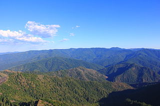
The Tonto National Forest, encompassing 2,873,200 acres, is the largest of the six national forests in Arizona and is the ninth largest national forest in the United States. The forest has diverse scenery, with elevations ranging from 1,400 feet in the Sonoran Desert to 7,400 feet in the ponderosa pine forests of the Mogollon Rim. The Tonto National Forest is also the most visited "urban" forest in the United States.

<span class="mw-page-title-main">Coconino National Forest</span> United States protected area in Arizona

The Coconino National Forest is a 1.856-million acre United States National Forest located in northern Arizona in the vicinity of Flagstaff, with elevations ranging from 2,600 feet to the highest point in Arizona at 12,633 feet. Originally established in 1898 as the "San Francisco Mountains National Forest Reserve", the area was designated a U.S. National Forest by Pres. Theodore Roosevelt on July 2, 1908, when the San Francisco Mountains National Forest Reserve was merged with lands from other surrounding forest reserves to create the Coconino National Forest. Today, the Coconino National Forest contains diverse landscapes, including deserts, ponderosa pine forests, flatlands, mesas, alpine tundra, and ancient volcanic peaks. The forest surrounds the towns of Sedona and Flagstaff and borders four other national forests; the Kaibab National Forest to the west and northwest, the Prescott National Forest to the southwest, the Tonto National Forest to the south, and the Apache-Sitgreaves National Forest to the southeast. The forest contains all or parts of nine designated wilderness areas, including the Kachina Peaks Wilderness, which includes the summit of the San Francisco Peaks. The headquarters are in Flagstaff. The Coconino National Forest consists of three districts: Flagstaff Ranger District, Mogollon Rim Ranger District, and Red Rock Ranger District, which have local ranger district offices in Flagstaff, Happy Jack, and Sedona.

<span class="mw-page-title-main">Mokelumne River</span> River in northern California

The Mokelumne River is a 95-mile (153 km)-long river in northern California in the United States. The river flows west from a rugged portion of the central Sierra Nevada into the Central Valley and ultimately the Sacramento–San Joaquin River Delta, where it empties into the San Joaquin River-Stockton Deepwater Shipping Channel. Together with its main tributary, the Cosumnes River, the Mokelumne drains 2,143 square miles (5,550 km2) in parts of five California counties. Measured to its farthest source at the head of the North Fork, the river stretches for 157 miles (253 km).

<span class="mw-page-title-main">Hells Canyon Wilderness (Oregon and Idaho)</span> Wilderness area in Idaho and Oregon

The Hells Canyon Wilderness is a wilderness area in the western United States, in Idaho and Oregon. Created 49 years ago in 1975, the Wilderness is managed by both the U.S. Bureau of Land Management and the U.S. Forest Service and contains some of the most spectacular sections of the Snake River as it winds its way through Hells Canyon, North America's deepest river gorge and one of the deepest gorges on Earth. The Oregon Wilderness Act of 1984 added additional acreage and currently the area protects a total area of 217,927 acres (88,192 ha). It lies entirely within the Hells Canyon National Recreation Area except for a small 946-acre (383 ha) plot in southeastern Wallowa County, Oregon which is administered by the Bureau of Land Management. The area that is administered by the Forest Service consists of portions of the Wallowa, Nez Perce, Payette, and Whitman National Forests.

<span class="mw-page-title-main">Gila National Forest</span> Protected area in New Mexico, U.S.

The Gila National Forest is a United States National Forest in New Mexico. Established in 1905, it now covers approximately 2,710,659 acres (10,969.65 km2), making it the sixth largest National Forest in the continental United States. The Forest administration also manage the part of the Apache National Forest in New Mexico which covers 614,202 acres for a total of 3.3 million acres managed by the Gila National Forest. Within the forest, the Gila Wilderness was established in 1924 as the US's first designated wilderness. The Aldo Leopold Wilderness and Blue Range Wilderness are also found within its borders. The Blue Range Primitive Area lies within Arizona in the neighboring Apache National Forest.

<span class="mw-page-title-main">Sespe Creek</span> Stream in California

Sespe Creek is a stream, some 61 miles (98 km) long, in Ventura County, southern California, in the Western United States. The creek starts at Potrero Seco in the eastern Sierra Madre Mountains, and is formed by more than thirty tributary streams of the Sierra Madre and Topatopa Mountains, before it empties into the Santa Clara River in Fillmore.

<span class="mw-page-title-main">Oak Creek Canyon</span> River gorge located in northern Arizona between the cities of Flagstaff and Sedona

Oak Creek Canyon is a river gorge located in northern Arizona between the cities of Flagstaff and Sedona. The canyon is often described as a smaller cousin of the Grand Canyon because of its scenic beauty. State Route 89A enters the canyon on its north end via a series of hairpin turns before traversing the bottom of the canyon for about 13 miles (21 km) until the highway enters the town of Sedona.

<span class="mw-page-title-main">Sycamore Canyon (Yavapai County, Arizona)</span> Landform in Yavapai County, Arizona

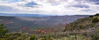
Sycamore Canyon is the second largest canyon in the Arizona redrock country, after Oak Creek Canyon. The 21-mile (34 km) long scenic canyon reaches a maximum width of about 7 miles (11 km). It is in North Central Arizona bordering and below the Mogollon Rim, and is located west and northwest of Sedona in Yavapai and Coconino counties.

<span class="mw-page-title-main">Childs-Irving Hydroelectric Facilities</span> United States historic place

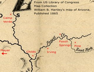
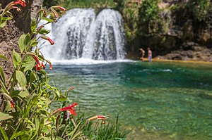
Childs-Irving Hydroelectric Facilities consisted of two 20th-century power plants, a dam, and related infrastructure along or near Fossil Creek in the U.S. state of Arizona. The complex was named an Historic Mechanical Engineering Landmark in 1971 and was added to the National Register of Historic Places 20 years later. Decommissioned in 2005, the plants no longer produce electricity, and much of the infrastructure—including the dam, the Irving Power Plant, and thousands of feet of concrete flumes—have been removed, and the creek's original flow has been restored.

<span class="mw-page-title-main">Sycamore Canyon Wilderness</span> Protected area in northern Arizona

Sycamore Canyon Wilderness is a 56,000-acre wilderness area in the Coconino, Kaibab and Prescott national forests in the U.S. state of Arizona. Encompassing Sycamore Canyon and its surrounds from south of Williams to the confluence of Sycamore Creek with the Verde River, the wilderness is about 40 miles (64 km) southwest of Flagstaff. The canyon is one of several in Arizona that cut through the Mogollon Rim. Relevant United States Geological Survey (USGS) map quadrangles are Davenport Hill, White Horse Lake, May Tank Pocket, Perkinsville, Sycamore Basin, and Clarkdale. Red Rock-Secret Mountain Wilderness borders Sycamore Canyon Wilderness on the east.

<span class="mw-page-title-main">Wild Rogue Wilderness</span>

The Wild Rogue Wilderness is a wilderness area surrounding the 84-mile (135 km) Wild and Scenic portion of the Rogue River in southwestern Oregon, U.S. to protect the watershed. The wilderness was established in 1978 and now comprises 35,818 acres (14,495 ha). Because it spans part of the Rogue River-Siskiyou National Forest and the Medford district of the Bureau of Land Management (BLM), the Wild Rogue Wilderness is administered by both the BLM and the Forest Service.

<span class="mw-page-title-main">Wenaha River</span> River in Oregon, United States

The Wenaha River is a tributary of the Grande Ronde River, about 22 miles (35 km) long, in the U.S. state of Oregon. The river begins at the confluence of its north and south forks in the Blue Mountains and flows east through the Wenaha–Tucannon Wilderness to meet the larger river at the small settlement of Troy. A designated Wild and Scenic River for its entire length, the stream flows wholly within Wallowa County.

The North Fork Malheur River is a 59-mile (95 km) tributary of the Malheur River in eastern Oregon in the United States. Rising in Big Cow Burn in the Blue Mountains, it flows generally south to join the larger river at Juntura. The upper 25.5 miles (41.0 km) of the river have been designated Wild and Scenic. This part of the river basin offers camping, hiking, and fishing opportunities in a remote forest setting. The lower river passes through Beulah Reservoir, which stores water for irrigation and has facilities for boaters.

The Matilija Wilderness is a 29,207-acre (11,820 ha) wilderness area in Ventura and Santa Barbara Counties, Southern California. It is managed by the U.S. Forest Service, being situated within the Ojai Ranger District of the Los Padres National Forest. It is located adjacent to the Dick Smith Wilderness to the northwest and the Sespe Wilderness to the northeast, although it is much smaller than either one. The Matilija Wilderness was established in 1992 in part to protect California condor habitat.

References

  1. 1 2 3 4 5 6 "Childs Irving Hydroelectric Project History". APS. Archived from the original on May 10, 2012. Retrieved November 18, 2012.
  2. 1 2 3 4 "Fossil Creek". Geographic Names Information System. United States Geological Survey. February 8, 1980. Retrieved November 15, 2012.
  3. Source elevation derived from Google Earth search using GNIS source coordinates.
  4. 1 2 3 4 5 6 Duperrault 2003, pp. 10–13.
  5. 1 2 3 4 5 6 United States Geological Survey (USGS). "United States Geological Survey Topographic Map". TopoQuest. Retrieved November 19, 2012. The relevant map quadrangles are Strawberry, Hackberry Mountain, and Verde Hot Springs. Intermittent flows are indicated on the map by lines of spaced dashes. The total length of the upper (intermittent) creek is an estimate based on map scale and ruler.
  6. 1 2 3 "Water-Data Report 2011: 09507480 Fossil Creek Near Strawberry, AZ" (PDF). U.S. Geological Survey. Retrieved November 20, 2012.
  7. 1 2 Schlinger, Charlie (March 28, 2004). "Fossil Creek Gaging Station Alternatives Evaluation and Recommendations" (PDF). Northern Arizona University. Retrieved November 21, 2012.[ permanent dead link ]
  8. 1 2 Fossil Creek Area (PDF) (Map). U.S. Forest Service. Archived from the original (PDF) on November 5, 2013. Retrieved November 21, 2012.
  9. Duperrault 2003, pp. 13–14.
  10. 1 2 3 4 5 6 7 Malusa, John; Overby, StevenT.; Parnell, Roderic A. (2003). "Potential for Travertine Formation" (PDF). Applied Geochemistry. 18 (7): 1081–93. Bibcode:2003ApGC...18.1081M. CiteSeerX   10.1.1.190.5954 . doi:10.1016/s0883-2927(02)00241-x. Archived (PDF) from the original on May 25, 2014. Retrieved November 25, 2012.
  11. Plummer & McGeary 1988, pp. 252, 529.
  12. Fuller, Brian M.; Sklar, Leonard S.; Compson, Zacchaeus G.; Adams, Kenneth J.; Marks, Jane C.; Wilcox, Andrew C. (March 2011). "Ecogeomorphic feedbacks in regrowth of travertine step-pool morphology after dam decommissioning, Fossil Creek, Arizona". Geomorphology. 126 (3–4): 314–332. Bibcode:2011Geomo.126..314F. doi:10.1016/j.geomorph.2010.05.010.
  13. 1 2 Canode, Jay (February 21, 2011). "Arizona's Fossil Creek Gets Restored -- and Loved to Death". High Country News. Archived from the original on July 23, 2012. Retrieved November 16, 2012.
  14. U.S. Forest Service 2011, p. 14.
  15. 1 2 Springer, Abe; Ledbetter, Jeri (2011). "Arizona Heritage Waters: Fossil Creek". Northern Arizona University. Retrieved November 18, 2012.
  16. 1 2 Munderloh, Terry (March 4, 2007). "Harnessing the Water Power of Fossil Creek". Sharlot Hall Museum. Archived from the original on June 5, 2014. Retrieved November 18, 2012.
  17. 1 2 3 McKinnon, Shaun (December 27, 2008). "State Trying to Protect the Lush Fossil Creek". The Arizona Republic. Gannett. Retrieved November 16, 2012.
  18. National Park Service (2004). "Childs-Irving Hydroelectric Project: HAER No. AZ-65" (PDF). Arizona Public Service. p. 9. Archived from the original (PDF) on May 25, 2006. Retrieved November 20, 2012.
  19. U.S. Forest Service 2011, p. 79.
  20. "Future of Childs-Irving Power Plants on the Line". Payson Roundup. November 16, 1998. Archived from the original on January 31, 2013. Retrieved November 21, 2012.
  21. 1 2 Marks, Jane C.; Haden, George A.; O’Neill, Matthew; Pace, Cinnamon (2010). "Effects of Flow Restoration and Exotic Species Removal on Recovery of Native Fish: Lessons from a Dam Decommissioning". Restoration Ecology. 18 (6): 934–943. doi:10.1111/j.1526-100X.2009.00574.x. ISSN   1526-100X. S2CID   21724032.
  22. Ayers, Steve (April 2, 2009). "Fossil Creek Gets 'Wild and Scenic' Designation". Camp Verde Bugle. Western News & Info. Archived from the original on March 17, 2012. Retrieved November 16, 2012.
  23. U.S. Forest Service 2011, p. 1.
  24. "Arizona". National Wild and Scenic Rivers System. Retrieved November 20, 2012.
  25. 1 2 3 U.S. Forest Service 2011, pp. 19–25.
  26. 1 2 3 U.S. Forest Service 2011, pp. 15–18.
  27. 1 2 3 U.S. Forest Service 2011, pp. 31–33.
  28. 1 2 U.S. Forest Service 2011, pp. 10–12.
  29. "Visit Fossil Creek". U.S. Forest Service. Retrieved July 15, 2019.
  30. "Fossil Creek Wild and Scenic River". Recreation.gov. 2014. Retrieved August 10, 2018.
  31. "Fossil Creek Comprehensive River Management Plan". U.S. Forest Service. Archived from the original on May 3, 2015. Retrieved June 19, 2014.

Sources