Cape Krusenstern National Monument

Last updated
Cape Krusenstern National Monument
IUCN category V (protected landscape/seascape)
Tundra River (20258476344).jpg
Relief map of USA Alaska.png
Red pog.svg
Location Northwest Arctic Borough, Alaska, United States
Nearest city Kotzebue, Alaska
Coordinates 67°20′N163°35′W / 67.333°N 163.583°W / 67.333; -163.583 Coordinates: 67°20′N163°35′W / 67.333°N 163.583°W / 67.333; -163.583
Area649,082 acres (2,626.74 km2) [1]
CreatedDecember 2, 1980 (1980-December-02)
Visitors15,087(in 2018) [2]
Governing body National Park Service
Website Cape Krusenstern National Monument
Cape Krusenstern Archeological District National Monument
Alaska Heritage Resources Survey
LocationAddress restricted [3]
Nearest city Kotzebue, Alaska
NRHP reference No. 73000378 [4]
AHRS No.NOA-042
Significant dates
Added to NRHPNovember 7, 1973
Designated NHLNovember 7, 1973 [5]

Cape Krusenstern National Monument and the colocated Cape Krusenstern Archeological District is a U.S. National Monument and a National Historic Landmark [6] centered on Cape Krusenstern in northwestern Alaska. The national monument was one of fifteen new National Park Service units designated by the Alaska National Interest Lands Conservation Act (ANILCA) of 1980. It was initially declared a national monument under the authority of the Antiquities Act by President Jimmy Carter on December 1, 1978.

Contents

Cape Krusenstern is primarily a coastal plain, containing large lagoons and rolling hills of limestone. The bluffs record thousands of years of change in the shorelines of the Chukchi Sea, as well as evidence of some 9,000 years of human habitation. The park's central features, 114 beach ridges at the eponymous cape, alternate between sandy and gravelly ridges and narrow ponds. Located entirely above the Arctic Circle in a region of permafrost, the monument's lands include typical thermokarst features.

Description

Cape Krusenstern National Monument comprises the coast of the Chukchi Sea from the opening of the Hotham Inlet at the mouth of the Kobuk River, extending northwards along the coast to a point just short of Imikruk Lagoon. It extends inland about 20 miles (32 km), with a high point in the north at Kikmiksot Mountain (2,285 feet (696 m)) in the Mulgrave Hills and in the south at Mount Noak (2,010 feet (610 m)) in the Igichuk Hills. The coastline is marked by a series of lagoons separated from the sea by sandspits. The largest is the Krusenstern Lagoon at Cape Krusenstern. Others include the Kotlik Lagoon, Imik Lagoon and Aukulak Lagoon. [7]

The local bedrock is composed of limestone, dolomite, phyllite and chert from the Precambrian through Devonian times. The land was glaciated during the Illinoian glaciation, but was free of permanent ice during the Wisconsonian glaciation. Longshore currents have deposited beach ridges since then for 6,000 years. [8]

Archaeological district

The archeological district comprises 114 ancient beach ridges which formed approximately 60 years apart. They provide a sequential look at over 5000 years of habitation. [5] The area in the National Historic Landmark is vast, making this one of the largest NHLs in the U.S., along with the Adirondack Park. [9] The national historic landmark was designated on November 7, 1973. [5]

The beach ridges are the primary reason for the area's preservation, which serves to safeguard evidence of 5,000 years of occupation by the Inupiat people, [10] and more than 9,000 years of human occupation. [11] Initial investigations by archaeologist J. Louis Giddings in the late 1940s found campsites on the cape as much as 4,000 years old, and even older sites on the mainland. [8] University of Washington researchers have undertaken several years of excavations to document about one third of the 9,000-acre (3,600 ha) beach complex. Researchers found campsites, hearths and animal bones, with a few stone tools and pieces of pottery. In newer locations the team documented the remains of semi-subterranean houses built into the beach ridges, such as the Old Whaling site. [12] [13]

The oldest mainland sites such as Battle Rock, Rabbit Mountain and the Lower Bench date to the Paleo-Arctic tradition, about 10,000 to 7,000 years before present. Similar materials have been recovered in the Trail Creek caves of Bering Land Bridge National Preserve on the Seward Peninsula. The Palisades site has yielded materials from the Northern Archaic period dating to about 6,000 years before the present. Later periods described in the region include the Arctic Small Tool tradition and the Northern Maritime tradition. The western Thule culture, which used dogs and seal oil extended from 950 AD to 1400, and was succeeded by the Kotzebue culture from about 1400 to about 1850, when Europeans began to affect native cultures. Kotzebue sites are widespread within the monument. [8]

Later history

Family on spring ice of Krusenstern Lagoon on an egg hunting trip, 1973 Eskimo family on spring ice of Krusenstern Lagoon on an egg hunting trip (33509512556).jpg
Family on spring ice of Krusenstern Lagoon on an egg hunting trip, 1973

Europeans visited the Cape Krusenstern region to pursue whales beginning in the 1850s. During the American Civil War the Confederate raider CSS Shenandoah captured whalers in the area. [8]

In early modern times the Kotzebue area was the site of Qatnut, a kind of trade fair for the region's native people. Qatnut is still celebrated in modern times in the city of Kotzebue, Alaska every other summer. A short-lived gold rush brought prospectors to the Seward Peninsula and Kotzebue in the 1890s. A few 20th century structures exist in the monument, including an Alaska Road Commission cabin at Anigaaq that has been evaluated for historic significance. [8] In the 1950s the area's lack of good natural harbors, a desire to develop the Alaskan frontier facing the Soviet Union and the Operation Plowshare drive for the peaceful use of nuclear weapons brought proposals for Operation Chariot, a proposed deepwater harbor at Cape Thompson 50 miles (80 km) northwest of the monument, to be excavated using nuclear devices. The project, though popular elsewhere in Alaska, was opposed by native leaders and was discarded. [8]

Ecology and environment

Muskoxen at Cape Krusenstern Muskox and Geese.jpg
Muskoxen at Cape Krusenstern

The lands within the monument, which lies entirely above the Arctic Circle, are all tundra in which the permafrost dominates soils and vegetation. [14] The monument is in a permafrost region. In the lowland areas the land is shaped by thermokarst forces. Typical thermokarst features seen in the monument include pingos, polygon ice wedges and thaw ponds. [8] Low vegetation covers the land, mainly in tussocks of cottongrass, with shrubby growth of willow, Labrador tea, dwarf birch, mountain alder and other species in moist tundra areas. Wetter areas in the southern part of the monument feature grasses and sedges. Upland regions are Arctic tundra, with lichen, saxifrage, willow and heather. Few trees grow, and the white spruce that do grow are confined to the southeastern corner of the monument. [8]

The coastal region supports a variety of large terrestrial and marine mammals. The abundant caribou are part of the West. Large predators include brown bears and wolf packs. [14] Smaller mammals include snowshoe and Arctic hares, weasels, minks, otters, porcupines and a few wolverines. Marine mammals in or near monument waters include fin, bowhead, gray and beluga whales. Seal species include ringed, spotted, bearded and ribbon seals, with occasional walruses. Ringed seals are hunted by native subsistence hunters, and occasionally beluga whales and walrus are hunted as well. [8]

Fish species include five species of salmon, burbot, several species of whitefish, Arctic char, Dolly Varden trout, herring and northern pike. [8]

Water birds of all kinds nest in the monument. Nesting species include tundra swan, mallard, green-winged teal, common eider, Canada goose, and horned and red-necked grebes. Sandhill cranes also nest on the tundra, with common, Arctic and yellow-billed loons. Seabirds include glaucous gulls, Arctic terns, long-tailed jaegers and common murres. Landbirds include willow and rock ptarmigans. Predatory landbirds include peregrine falcons, snowy owls and goshawks. [8] Endangered species at Cape Krusenstern include the possibly extinct Eskimo curlew, and threatened spectacled eider and Steller's eider. [15]

Weather in the coastal monument is subject to extremes. Average low temperatures in January are 5 °F (−15 °C), and can reach nighttime lows of −50 °F (−46 °C). Summer temperatures average around 55 °F (13 °C), and can reach 70 °F (21 °C). Since the park is above the Arctic Circle, the sun does not set from June 3 to July 9, and the sun is visible for only 1+12 hours on the winter solstice, with long periods of twilight on either side of sunrise and sunset. As is the case over all of northern Alaska, the aurora borealis is often visible on winter nights when solar activity is high. Snow can happen at any time of the year. The coast can be stormy, with winds of 50 miles per hour (80 km/h) to 70 miles per hour (110 km/h). Visitors must take care against hypothermia in the cool, damp environment. [16]

Mining

The Red Dog mine is the world's largest zinc mine. The mine opened in 1989, located about 30 miles (48 km) northeast of the monument, close to Noatak National Preserve on land owned by the NANA Regional Corporation, an Alaskan native corporation. The mine is operated by Teck Cominco Alaska. A haul road from the mine crosses monument lands to a small port facility on the monument's shore a few miles south of the northern boundary, from which the concentrated lead and zinc powder is shipped during the 100 ice-free days of the year. About 20 miles (32 km) of the 55-mile (89 km) road are within the monument. [17] A 2006 study measured high lead and cadmium concentrations in voles and birds sampled near the road compared to those at a control location. The animal sample was a follow-up to an earlier study that found elevated lead and cadmium levels in mosses near the road. The contamination is attributed to dust blown from trucks on the haul road. Following the first study changes were made to the trucks to contain dust and a sampling program was put into effect to monitor dust release. [18]

History and administration

Muskoxen with rainbow Muskoxen with mountains and rainbow sky in the distance.jpg
Muskoxen with rainbow

Cape Krusenstern National Monument was established as one of fifteen new National Park Service properties established by the Alaska National Interest Lands Conservation Act (ANILCA) of 1980. It was first declared a national monument by President Jimmy Carter on December 1, 1978 using his authority under the Antiquities Act when Congressional negotiations on the proposed ANILCA bill were stalled. ANILCA was finally passed in 1980, and signed by Carter on December 2, 1980. As is the case in most national park lands in Alaska, subsistence hunting by local residents is permitted. No part of the monument is designated as a national preserve, which would allow sport hunting. [19] About 19% of monument lands are owned by native corporations. [8]

The monument's headquarters are at the Northwest Arctic Heritage Center in Kotzebue, across the Hotham Inlet from Cape Krusenstern. [20] Offices and visitor services for Kobuk Valley National Park and Noatak National Preserve are in the same facility. [21] [22] The units are managed together as the Western Arctic National Parklands, with a single Park Service superintendent in charge. [23]

See also

Related Research Articles

<span class="mw-page-title-main">Northwest Arctic Borough, Alaska</span> Borough in Alaska, United States

Northwest Arctic Borough is a borough located in the U.S. state of Alaska. As of the 2020 census, the population was 7,793, up from 7,523 in 2010. The borough seat is Kotzebue. The borough was formed on June 2, 1986.

<span class="mw-page-title-main">Kotzebue, Alaska</span> City in Alaska, United States

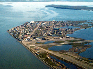
Kotzebue or Qikiqtaġruk is a city in the Northwest Arctic Borough in the U.S. state of Alaska. It is the borough's seat, by far its largest community and the economic and transportation hub of the subregion of Alaska encompassing the borough. The population of the city was 3,102 as of the 2020 census, down from 3,201 in 2010. The city has received an All-America City award.

<span class="mw-page-title-main">Iñupiat</span> Ethnic group

The Iñupiat are a group of Alaska Natives, whose traditional territory roughly spans northeast from Norton Sound on the Bering Sea to the northernmost part of the Canada–United States border. Their current communities include 34 villages across Iñupiat Nunaat including seven Alaskan villages in the North Slope Borough, affiliated with the Arctic Slope Regional Corporation; eleven villages in Northwest Arctic Borough; and sixteen villages affiliated with the Bering Straits Regional Corporation, and often claim to be the first people of the Kauwerak.

<span class="mw-page-title-main">Gates of the Arctic National Park and Preserve</span> National park in Alaska, United States

Gates of the Arctic National Park and Preserve is an American national park that protects portions of the Brooks Range in northern Alaska. The park is the northernmost national park in the United States, situated entirely north of the Arctic Circle. The area of the park and preserve is the second largest in the U.S. at 8,472,506 acres, slightly larger in area than Belgium; the National Park portion is the second largest in the U.S., after the National Park portion of Wrangell–St. Elias National Park and Preserve.

<span class="mw-page-title-main">Kobuk Valley National Park</span> National park in Alaska, United States

Kobuk Valley National Park is an American national park in the Arctic region of northwestern Alaska, located about 25 miles (40 km) north of the Arctic Circle. The park was designated in 1980 by the Alaska National Interest Lands Conservation Act to preserve the 100 ft (30 m) high Great Kobuk Sand Dunes and the surrounding area which includes caribou migration routes. Park visitors must bring all their own gear for backcountry camping, hiking, backpacking, boating, and dog sledding. No designated trails or roads exist in the park, which at 1,750,716 acres, is slightly larger than the state of Delaware. Kobuk Valley is one of eight national parks in Alaska, the state with the second most national parks, surpassed only by California which has nine. The park is managed by the National Park Service.

<span class="mw-page-title-main">Alaska National Interest Lands Conservation Act</span> United States federal law providing protection to certain areas in Alaska

The Alaska National Interest Lands Conservation Act (ANILCA) is a United States federal law signed by President Jimmy Carter on December 2, 1980. ANILCA provided varying degrees of special protection to over 157,000,000 acres (64,000,000 ha) of land, including national parks, national wildlife refuges, national monuments, wild and scenic rivers, recreational areas, national forests, and conservation areas. It was, and remains to date, the single largest expansion of protected lands in history and more than doubled the size of the National Park System.

<span class="mw-page-title-main">Kotzebue Sound</span>

Kotzebue Sound is an arm of the Chukchi Sea in the western region of the U.S. state of Alaska. It is on the north side of the Seward Peninsula and bounded on the east by the Baldwin Peninsula. It is 100 miles (160 km) long and 70 miles (110 km) wide.

<span class="mw-page-title-main">Hotham Inlet</span>

Hotham Inlet, also known as Kobuk Lake, is an arm of Kotzebue Sound on the northwestern coast of the U.S. state of Alaska. It is 50 miles (80 km) long and 5–20 miles (8–32 km) wide. The inlet is the outlet of the Kobuk and Selawik Rivers and it is bounded on the southwest by the Baldwin Peninsula.

<span class="mw-page-title-main">Noatak River</span> River in the northwestern Alaska

The Noatak River is a river in the northwestern part of the U.S. state of Alaska.

<span class="mw-page-title-main">Noatak National Preserve</span> National Preserve along the Noatak River in northwestern Alaska

Noatak National Preserve is a United States National Preserve in northwestern Alaska that was established to protect the Noatak River Basin. The Noatak River system, located just north of the Arctic Circle, is thought to be the last remaining complete river system in the United States that has not been altered by human activities. The roadless basin was proclaimed a United States National Monument in 1978 and a National Preserve in 1980 through the passage of the Alaska National Interest Lands Conservation Act (ANILCA). Noatak National Preserve borders Kobuk Valley National Park on the south and Gates of the Arctic National Park on the east. Unlike the national parks that it borders, sport hunting is allowed in Noatak National Preserve.

<span class="mw-page-title-main">Cape Krusenstern</span> Cape in Alaska, United States of America

Cape Krusenstern is a cape on the northwestern coast of the U.S. state of Alaska, located near the village of Kivalina at 67°07′41″N163°44′43″W.

<span class="mw-page-title-main">Selawik National Wildlife Refuge</span>

Selawik National Wildlife Refuge in northwest Alaska in the Waring Mountains was officially established in 1980 with the passage of the Alaska National Interest Lands Conservation Act (ANILCA).

<span class="mw-page-title-main">Bering Land Bridge National Preserve</span>

The Bering Land Bridge National Preserve is one of the most remote Protected areas of the United States, located on the Seward Peninsula. The National Preserve protects a remnant of the Bering Land Bridge that connected Asia with North America more than 13,000 years ago during the Pleistocene ice age. The majority of this land bridge now lies beneath the waters of the Chukchi and Bering Seas. During the glacial epoch this bridge was a migration route for people, animals, and plants whenever ocean levels fell enough to expose the land bridge. Archeologists disagree whether it was across this Bering Land Bridge, also called Beringia, that humans first migrated from Asia to populate the Americas, or whether it was via a coastal route.

Maniiḷaq is a figure of Iñupiat legend and history. He is said to have lived in the 19th century before colonialists arrived in his area of northwest Alaska. He lived as a hunter and a healer in northwest Alaska. Various stories about him include that he heard voices predicting that people would come to Alaska, that he had prophetic visions of boats that were propelled by fire or that flew in the air, and that he heard voices from a higher power who he said identified as abba. Some also say that Maniiḷaq rested every seventh day. Other prophecies attributed to Maniiḷaq include the prophecy that the village of Ambler, Alaska would one day become a large metropolis, and that a whale would swim upriver and appear at Ambler. It is said that Maniiḷaq practiced traditional medicine, and also that he resisted the dominant cultural order of shamanism. He is an important figure in Northwest Alaska Christian communities. The most distant future event he predicted was a day that was split in two, which is probably a reference to the Solar eclipse of July 1, 2057.

The Murie Science and Learning Center is a collaboration between the Denali National Park and Preserve, seven additional National Parks and several park partners.." The Murie Science and Learning Center promotes scientific research to aid park managers and provide science-based education programs and information to students, educational institutions and the visiting public.

<span class="mw-page-title-main">Cape Espenberg</span>

Cape Espenberg is a cape located on the Seward Peninsula in Alaska, on the Chukchi Sea coast.

<span class="mw-page-title-main">Onion Portage Archeological District</span> Archaeological site in Alaska, United States

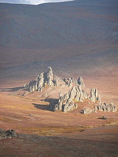
The Onion Portage Archeological District encompasses a major archaeological site in Kobuk Valley National Park in northwestern Alaska. The site is a deeply stratified site, at which archaeologists have located nine complexes ranging dating from approximately 6500BC to AD1700. The site has been of critical benefit for the study of Arctic cultures, and is used to determine the cultural chronology of the region.

Native American heritage sites are sites specifically created in many National Park Sites in the United States to commemorate the contribution of the Native American cultures. The term ‘Native American’ includes all cultural groups that predate the arrival of either western European or East coast explorers and settlers. In this sense, Native Alaskans of both arctic and sub-arctic cultures are included with the American Indians of the continental United States. Native Hawaiians are included as the traditional cultures of the islands.

<span class="mw-page-title-main">Baird Mountains</span> Mountain range in Alaska, United States

The Baird Mountains are a mountain range located northeast of the Kotzebue Sound, in between the Kobuk and Noatak Rivers in Alaska. The range was named after Smithsonian Institution Secretary Spencer F. Baird.

<span class="mw-page-title-main">Western Arctic National Parklands</span>

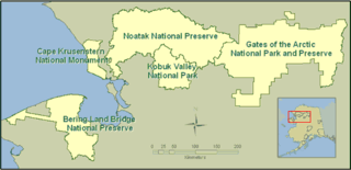
The Western Arctic National Parklands describes four United States National Park Service units in western Alaska that are managed by a single park superintendent and their staff. The western Arctic parklands are Kobuk Valley National Park, Noatak National Preserve, Cape Krusenstern National Monument, and Bering Land Bridge National Preserve. The four units have a total area of about 11,000,000 acres (4,500,000 ha) and are managed from the Northwest Arctic Heritage Center in Kotzebue, Alaska. Bering Land Bridge National Preserve has administrative offices in Nome.

References

  1. "Listing of acreage – December 31, 2011" (XLSX). Land Resource Division, National Park Service. Retrieved 2012-03-23. (National Park Service Acreage Reports)
  2. "NPS Annual Recreation Visits Report". National Park Service. Retrieved 2019-10-26.
  3. Federal and state laws and practices restrict general public access to information regarding the specific location of this resource. In some cases, this is to protect archeological sites from vandalism, while in other cases it is restricted at the request of the owner. See: Knoerl, John; Miller, Diane; Shrimpton, Rebecca H. (1990), Guidelines for Restricting Information about Historic and Prehistoric Resources, National Register Bulletin, National Park Service, U.S. Department of the Interior, OCLC   20706997 .
  4. "National Register Information System". National Register of Historic Places . National Park Service. July 9, 2010.
  5. 1 2 3 "Cape Krusenstern Archeological District". Archived from the original on October 7, 2012. Retrieved February 21, 2013.
  6. NHL Documentation
  7. Map of Cape Krusenstern National Monument (Map). National Park Service.
  8. 1 2 3 4 5 6 7 8 9 10 11 12 "Cape Krusenstern National Monument". Prehistory of Alaska. National Park Service. Retrieved 21 February 2013.
  9. Roberta Forsell Stauffer (2007-04-27). "Interior secretary approves district expansion". Newspaper article on expansion of National Historic Landmark Butte-Anaconda Historic District. The Montana Standard (newspaper). Retrieved 2007-11-01.
  10. "History & Culture". Cape Krusenstern National Monument. National Park Service. Retrieved 21 February 2013.
  11. "The Beach Ridges of the Cape". Cape Krusenstern National Monument. National Park Service. Retrieved 21 February 2013.
  12. "Places". Cape Krusenstern National Monument. National Park Service. Retrieved 21 February 2013.
  13. Giddings, J. Louis (1986). Beach ridge archeology of Cape Krusenstern : Eskimo and pre-Eskimo settlements around Kotzebue Sound, Alaska. National Park Service, U.S. Dept. of the Interior. OCLC   11519048.
  14. 1 2 "Nature and Science". Cape Krusenstern National Monument. National Park Service. Retrieved 21 February 2013.
  15. "Frequently Asked Questions". Cape Krusenstern National Monument. National Park Service. Retrieved 21 February 2013.
  16. "Weather". Cape Krusenstern National Monument. National Park Service. Retrieved 21 February 2013.
  17. "Red Dog Mine". Alaska Department of Environmental Conservation. Archived from the original on 30 March 2013. Retrieved 22 February 2013.
  18. Repanshek, Kurt (February 13, 2009). "Heavy Metals Detected in Wildlife of Cape Krusenstern National Monument". National Parks Traveler. Retrieved 22 February 2013.
  19. "Things to Know Before You Come". Cape Krusenstern National Monument. National Park Service. Retrieved 21 February 2013.
  20. "Operating Hours and Seasons". Cape Krusenstern National Monument. National Park Service. Retrieved 21 February 2013.
  21. "Operating Hours and Seasons". Noatak National Preserve. National Park Service. Retrieved 21 February 2013.
  22. "Northwest Arctic Heritage Center, Kotzebue, Alaska". Kobuk Valley National Park. National Park Service. Retrieved 21 February 2013.
  23. Quinley, John. "Superintendent Named for Western Arctic National Parklands". Kobuk Valley National Park. National Park Service. Retrieved 21 February 2013.

Bibliography