Northeast Canyons and Seamounts Marine National Monument

Last updated
Northeast Canyons and Seamounts Marine National Monument
Northeast Canyons and Seamounts Marine National Monument map NOAA.png
Location Atlantic Ocean
Coordinates 39°42′13″N67°10′11″W / 39.70361°N 67.16972°W / 39.70361; -67.16972
Area4,913 square miles (12,720 km2)
CreatedSeptember 15, 2016 (2016-September-15)
Governing body U.S. Department of the Interior and U.S. Department of Commerce

The Northeast Canyons and Seamounts Marine National Monument is a marine national monument of the United States off the coast of New England, on the seaward edge of Georges Bank. It was created by President Barack Obama on September 15, 2016, as the first U.S. marine national monument in the Atlantic Ocean. [1] [2]

Contents

The area includes four underwater mountains and three deep-sea canyons. It is home to endangered whales and other rare species, some found nowhere else in the world. [2] [3]

Geography and geology

The Northeast Canyons and Seamounts Marine National Monument is located within the New England and mid-Atlantic regions, 130 miles southeast of Cape Cod. [1] It comprises a total area of 4,913 square miles, [1] and protects four underwater seamounts (Bear, Mytilus, Physalia, and Retriever Seamounts) and three submarine canyons in the edge of the continental shelf (Oceanographer, Lydonia, and Gilbert). [4]

Biology and ecology

The area is home to rare and endangered species, including sperm whales, fin whales, sei whales and Kemp’s ridley sea turtles. [5] According to marine scientists who have studied the area, it is an area of high biological diversity, containing many "hot spots" of seafloor and epipelagic life, as well as providing ecological connectivity across depths and along the continental margin. As such, it provides a relatively undisturbed reference site for future ecological research and on climate change impacts, promising many scientific discoveries. [6]

Creation

President Barack Obama designated the Northeast Canyons and Seamounts Marine National Monument (NCSMNM) on September 21, 2016, by signing Proclamation 9496. [1] This action was based on the power to proclaim national monuments granted by the U.S. Congress under the Antiquities Act of 1906 [7] to the president. [8] The Monument, which is located off the coast of New England, was the first fully protected marine reserve in the Atlantic Ocean. [9]

According to a White House press release, the Monument was created in response to half a century of calls to protect the area, due to its importance as a biodiversity hotspot, habitat for numerous rare and endangered species, and a valuable scientific and historical site. [1] [10]

According to the Proclamation, [1] the Northeast Canyons and Seamounts Marine National Monument is the smallest area feasible to provide necessary management; designating a smaller zone would lead to an inaccurate interpretation and protection of biodiversity within the fragile area. The designation of the Marine National Monument occurred after numerous meetings and deliberations with stakeholders including conservationists, community members, fishermen, and local businesses; administrative officials gathered social, economic, and environmental data to inform the creation of the Northeast Canyons and Seamounts Marine National Monument. [10]

Residing at depths of ~4,000 meters, deep sea corals and other foundational species are highly sensitive to anthropogenic disturbances such as bottom trawling and mining extractions. [1] The objective of the Northeast Canyons and Seamounts Marine National Monument is to maintain biodiversity for research, while encouraging and providing support to fisheries to become more efficient, resilient, and sustainable. [11] Within three years, following the creation of the Northeast Canyons and Seamounts Marine National Monument, NOAA and U.S. Fish and Wildlife Service will administer a management plan for the area, adapting to requests and changes. [12] Under the monument's status, stakeholders would continue to be engaged throughout the process through meetings with administrators. [11]

The final designation of the Northeast Canyons and Seamounts Marine National Monument protects 40% of the originally proposed area, after intense deliberation, considering equity to those affected. [13] Areas within the Marine National Monument will remain open to recreational fishing and all military activity. [1] Subsequent to the creation of the Marine National Monument, a 60-day transition period was allowed for all commercial industries, besides the Atlantic Lobster and Deep-Sea Red Crab fisheries, which were permitted to continue fishing in the area for seven years after the creation of the monument. [1] In order to evolve fishing industries into sustainable businesses, the National Oceanic and Atmospheric Administration (NOAA) was tasked to provide commercial fisheries with access to updated vessels and equipment, increasing efficiency and minimizing cost, as well as beneficial services to commercial fisheries, such as stock assessments and marine surveys. [10]

The monument area is also withdrawn from leasing for energy development. Two months after the monument's creation, President Obama also withdraw 26 additional canyons along the Outer Continental Shelf to the northeast and southwest of the monument from future mineral leasing. [14]

Controversy over fishing restrictions

Five commercial fishing industries, Massachusetts Lobstermen's Association, Atlantic Offshore Lobstermen's Association, Long Island Commercial Fishing Association, Garden State Seafood Association, and Rhode Island Fishermen's Alliance, took the creation of the Northeast Canyons and Seamounts Marine National Monument to court in early March 2017. [13] They stated that President Obama did not have the right to designate the Marine National Monument under the Antiquities Act. [13] In the case, Massachusetts Lobstermen's Association v. Wilbur Ross, the plaintiffs also argued that the 1906 Antiquities Act did not allow presidents to protect bodies of water, that the government lacked sufficient control of water many miles offshore, and that the nearly 5,000-square-mile monument was too large. [15] Furthermore, in a legal document published on March 29, 2017, the fishermen argued that the restrictions on commercial fishing at the Monument was unlawful and harmful to their businesses. [13]

The case, Massachusetts Lobstermen's Association v. Ross , was decided by United States District Court for the District of Columbia Judge James E. Boasberg, who ruled on October 5, 2018, that the Monument complied with the law, rejecting the plaintiffs' arguments regarding presidential jurisdiction. Boasberg wrote, "In all, plaintiffs offer no factual allegations explaining why the entire monument, including not just the seamounts and canyons but also their ecosystems, is too large...The Antiquities Act reaches lands both dry and wet", [15] which the Natural Resources Defense Council (NRDC) pointed out [16] was consistent with Supreme Court's June 6, 2005 ruling in Alaska v. United States that it was "clear" that "the Antiquities Act empowers the President to reserve submerged lands." [17]

In December 2018 the plaintiffs appealed the ruling to the U.S. Court of Appeals for the D.C. Circuit. [18] The U.S. Department of Justice filed a brief in support of the Monument [16] on May 29, 2019. [19] On December 27, 2019, the D.C. Court of Appeals upheld the lower court ruling on the same grounds, stating that federal law governing monuments did not apply solely to land, that the ocean was indeed within the jurisdiction of the federal government, and that restrictions placed on such areas were not required to be the "smallest area compatible" with management goals. [20]

The U.S. Supreme Court declined to review the Court of Appeals decision on March 22, 2021. [21]

Monument modification

On June 5, 2020, President Donald Trump signed a proclamation purporting to lift the restrictions on commercial fishing at the Monument but without modifying the boundaries. [22] [23] Environmental organizations that had campaigned for creation of the monument filed suit immediately. [24] The proclamation indicated that the boundaries of the Monument would not be affected. [23] The proclamation also stated that "appropriately managed commercial fishing would not put the objects of scientific and historic interest that the monument protects at risk," citing that many fish species used as justification for the original protections are highly migratory and that the Magnuson-Stevens Act, and other federal and state laws, provide sufficient protections. [22] The proclamation was applauded by fishing industry advocates, such as the National Coalition for Fishing Communities. [25]

Environmental groups such as the NRDC and the Center for Biological Diversity criticized the Proclamation. [24] The NRDC cited a July 23, 2018 Washington Post article that revealed that in 2017, the Trump administration’s staff intentionally concealed the fact that fishing vessels near the monument, in the words of the government, [24] [26] "generated 5% or less of their annual landings from within the monument", [9] which undermined the administration's rationale for reversing the restrictions on commercial fishing. [24] [26] The NRDC also pointed out that the government's own data showed that revenues and catch in the relevant fisheries were higher or the same following the monument's designation. [24] Gib Brogan, a fisheries analyst at Oceana, said, "Today’s proclamation is another nail in the coffin for both productive fisheries and healthy oceans in New England." [9] Additionally, a senior attorney for the Center for Biological Diversity, an organization that works to protect endangered species, said, "Gutting these safeguards attacks the very idea of marine monuments." [27]

On his first day in office, President Joe Biden signed an executive order, "Protecting Public Health and the Environment and Restoring Science to Tackle the Climate Crisis." [28] The president directed the heads of all federal agencies to review every policy adopted during the Trump administration that affects public health, protection of the environment, conservation of national treasures and monuments, and the promotion of environmental justice and climate change resilience. [28] The Secretary of the Interior was directed to review the boundaries and conditions established for the Bears Ears, Grand Staircase-Escalante, and Northeast Canyons and Seamounts national monuments that had been modified by presidential proclamation in 2017 and 2020 and recommend presidential or other legal actions to restore the monument boundaries and conditions for access. [28]

On October 8, 2021, President Biden restored the original protections for the national monument, prohibiting commercial fishing and phasing out crab and lobster fishing by 2023. [29] [30]

See also

Related Research Articles

<span class="mw-page-title-main">National monument (United States)</span> Monuments assigned protected status by presidents of the US

In the United States, a national monument is a protected area that can be created from any land owned or controlled by the federal government by proclamation of the president of the United States or an act of Congress. National monuments protect a wide variety of natural and historic resources, including sites of geologic, marine, archaeological, and cultural importance. In contrast, national parks in the U.S. must be created by Congressional legislation. Some national monuments were first created by presidential action and later designated as national parks by congressional approval.

<span class="mw-page-title-main">United States National System of Marine Protected Areas</span>

The National System of Marine Protected Areas of the United States is a national initiative designed to strengthen the protection of U.S. ocean, coastal, and Great Lakes resources through the coordination of existing marine protected areas (MPAs). The national system of MPAs consists of the group of MPA sites, networks, and systems established and managed by federal, state, territorial, tribal and/or local governments that collectively enhance conservation of the nation's marine heritage and represent its diverse ecosystems and resources. Although managed independently, national system MPAs work together at the regional and national levels to achieve common objectives for conserving the nation's important natural and cultural resources. The national system does not bring state, territorial or local sites under federal authority, nor does it restrict or change the management of any MPA.

<span class="mw-page-title-main">Antiquities Act</span> 1906 U.S. law allowing the president to create national monuments from federal lands

The Antiquities Act of 1906 is an act that was passed by the United States Congress and signed into law by Theodore Roosevelt on June 8, 1906. This law gives the president of the United States the authority to, by presidential proclamation, create national monuments from federal lands to protect significant natural, cultural, or scientific features. The Act has been used more than a hundred times since its enactment.

<span class="mw-page-title-main">National Marine Sanctuary</span> Zone in US waters designated for special protection

A U.S. National Marine Sanctuary is a zone within United States waters where the marine environment enjoys special protection. The program was established in 1972 by the Marine Protection, Research, and Sanctuaries Act and is currently administered by the National Ocean Service through the National Marine Sanctuaries Act (NMSA).

<span class="mw-page-title-main">Georges Bank</span> Oceanic bank in the North Atlantic

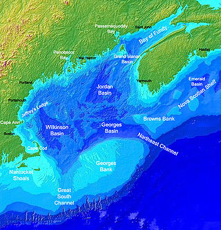
Georges Bank is a large elevated area of the sea floor between Cape Cod, Massachusetts, and Cape Sable Island, Nova Scotia (Canada). It separates the Gulf of Maine from the Atlantic Ocean.

<span class="mw-page-title-main">National Marine Fisheries Service</span> Office of the U.S. National Oceanic and Atmospheric Administration

The National Marine Fisheries Service (NMFS), informally known as NOAA Fisheries, is a United States federal agency within the U.S. Department of Commerce's National Oceanic and Atmospheric Administration (NOAA) that is responsible for the stewardship of U.S. national marine resources. It conserves and manages fisheries to promote sustainability and prevent lost economic potential associated with overfishing, declining species, and degraded habitats.

<span class="mw-page-title-main">Papahānaumokuākea Marine National Monument</span> Protected region of ocean and islands

The Papahānaumokuākea Marine National Monument (PMNM) is a World Heritage listed U.S. National Monument encompassing 583,000 square miles (1,510,000 km2) of ocean waters, including ten islands and atolls of the Northwestern Hawaiian Islands. It was created in June 2006 with 140,000 square miles (360,000 km2) and expanded in August 2016 by moving its border to the limit of the exclusive economic zone, making it one of the world's largest protected areas. It is internationally known for its cultural and natural values as follows:

The area has deep cosmological and traditional significance for living Native Hawaiian culture, as an ancestral environment, as an embodiment of the Hawaiian concept of kinship between people and the natural world, and as the place where it is believed that life originates and to where the spirits return after death. On two of the islands, Nihoa and Mokumanamana, there are archaeological remains relating to pre-European settlement and use. Much of the monument is made up of pelagic and deepwater habitats, with notable features such as seamounts and submerged banks, extensive coral reefs and lagoons.

<span class="mw-page-title-main">Pacific Remote Islands Marine National Monument</span> Group of unorganized United States Pacific Island territories

The Pacific Remote Islands Marine National Monument is a group of unorganized, mostly unincorporated United States Pacific Island territories managed by the United States Fish and Wildlife Service of the United States Department of the Interior and the National Oceanic and Atmospheric Administration (NOAA) of the United States Department of Commerce. These remote refuges are "the most widespread collection of marine- and terrestrial-life protected areas on the planet under a single country's jurisdiction". They protect many endemic species including corals, fish, shellfish, marine mammals, seabirds, water birds, land birds, insects, and vegetation not found elsewhere.

<span class="mw-page-title-main">Bear Seamount</span> Flat-topped underwater volcano in the Atlantic Ocean, the oldest of the New England Seamounts

The Bear Seamount is a guyot or flat-topped underwater volcano in the Atlantic Ocean. It is the oldest of the New England Seamounts, which was active more than 100 million years ago. It was formed when the North American Plate moved over the New England hotspot. It is located inside the Northeast Canyons and Seamounts Marine National Monument, which was proclaimed by President of the United States Barack Obama to protect the seamount's biodiversity.

<span class="mw-page-title-main">Howland and Baker Islands</span> Unincorporated U.S. territory

Howland Island and Baker Island are two uninhabited U.S. atolls in the Equatorial Pacific that are located close to one another. Both islands are wildlife refuges, the larger of which is Howland Island. They are both part of the larger political territory of the United States Minor Outlying Islands and they are also both part of the larger geographic grouping of the Phoenix Islands. Each is a National Wildlife Refuge managed by a division of Interior, the U.S. Fish and Wildlife Service. On January 6, 2009, U.S. President George W. Bush included both islands to the Pacific Remote Islands Marine National Monument.

<span class="mw-page-title-main">Fishing industry in the United States</span>

As with other countries, the 200 nautical miles (370 km) exclusive economic zone (EEZ) off the coast of the United States gives its fishing industry special fishing rights. It covers 11.4 million square kilometres, which is the second largest zone in the world, exceeding the land area of the United States.

<span class="mw-page-title-main">Marianas Trench Marine National Monument</span> US national monument in the Mariana Archipelago

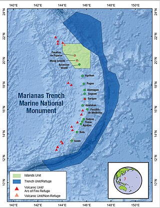
The Marianas Trench Marine National Monument is a United States National Monument created by President George W. Bush by the presidential proclamation no. 8335 on January 6, 2009. The monument includes no dry land area, but protects 95,216 square miles (246,610 km2) of submerged lands and waters in various places in the Mariana Archipelago. The United States could create this monument under international law because the maritime exclusive economic zones of the adjacent Northern Mariana Islands and Guam fall within its jurisdiction.

<span class="mw-page-title-main">Hotspot Ecosystem Research and Man's Impact On European Seas</span> International multidisciplinary project that studies deep-sea ecosystems

Hotspot Ecosystem Research and Man's Impact On European Seas (HERMIONE) is an international multidisciplinary project, started in April 2009, that studies deep-sea ecosystems. HERMIONE scientists study the distribution of hotspot ecosystems, how they function and how they interconnect, partially in the context of how these ecosystems are being affected by climate change and impacted by humans through overfishing, resource extraction, seabed installations and pollution. Major aims of the project are to understand how humans are affecting the deep-sea environment and to provide policy makers with accurate scientific information, enabling effective management strategies to protect deep sea ecosystems. The HERMIONE project is funded by the European Commission's Seventh Framework Programme, and is the successor to the HERMES project, which concluded in March 2009.

<span class="mw-page-title-main">Massachusetts Lobstermen's Association</span> Organization created to maintain and protect the lobster fishing in MA

The Massachusetts Lobstermen's Association (MLA) is an organization established in 1963 to maintain and protect the lobster fishing industry in Massachusetts. The mission of the MLA is to support "the interdependence of species conservation and the members’ collective economic interests" on the state and federal level. The organization has currently 1,800 members fishing out of fifty-two ports in Massachusetts and is based in Scituate.

<span class="mw-page-title-main">Bears Ears National Monument</span> Protected area in Utah

Bears Ears National Monument is a United States national monument located in San Juan County in southeastern Utah, established by President Barack Obama by presidential proclamation on December 28, 2016. The monument protects 1,351,849 acres of public land surrounding the Bears Ears—a pair of buttes—and the Indian Creek corridor rock climbing area. The Native American names for the buttes have the same meaning in each of the languages represented in the region. The names are listed in the presidential proclamation as "Hoon’Naqvut, Shash Jáa [sic], Kwiyaghatʉ Nükavachi/Kwiyagatu Nukavachi, Ansh An Lashokdiwe"—all four mean "Bears Ears".

<span class="mw-page-title-main">Marine policy of the Barack Obama administration</span>

The Marine Policy of the Barack Obama administration comprises several significant environmental policy decisions for the oceans made during his two terms in office from 2009 to 2017. By executive action, US President Barack Obama increased fourfold the amount of protected marine space in waters under United States control, setting a major precedent for global ocean conservation. Using the U.S. president's authority under the Antiquities Act of 1906, he expanded to 200 nautical miles the seaward limits of Papahānaumokuākea Marine National Monument in Hawaiʻi and the Pacific Remote Islands Marine National Monument around the U.S. island possessions in the Central Pacific. In the Atlantic, Obama created the Northeast Canyons and Seamounts Marine National Monument, the first marine monument in the U.S. exclusive economic zone (EEZ) in the Atlantic.

<span class="mw-page-title-main">Executive Order 13792</span>

Executive Order 13792, entitled "Review of Designations Under the Antiquities Act," is an executive order issued by US President Donald Trump on April 26, 2017, that directed the Secretary of the Interior to review designations of national monuments made since 1996. The order applies to all new monuments greater than 100,000 acres in size and monuments that were expanded by at least 100,000 acres. Twenty-two land monuments and five marine monuments that were created by the administrations of Bill Clinton, George W. Bush, and Barack Obama were subject to review.

The marine protected areas of South Africa are in an area of coastline or ocean within the exclusive economic zone (EEZ) of the Republic of South Africa that is protected in terms of specific legislation for the benefit of the environment and the people who live in and use it. An MPA is a place where marine life can thrive under less pressure than unprotected areas. They are like underwater parks, and this healthy environment can benefit neighbouring areas.

Massachusetts Lobstermen's Association v. Ross is a United States District Court case in the District of Columbia in which the court determined whether or not a President may establish a marine national monument, the Northeast Canyons and Seamounts Marine National Monument, under the authority of the Antiquities Act of 1906. The case represents the first time that the President's authority to create an offshore marine monument under the Act was directly challenged in court. While the District Court upheld the President's authority to designate the monument under the authority bestowed by the Antiquities Act, the case was appealed to the D.C. Circuit and awaits further judicial review.

References

  1. 1 2 3 4 5 6 7 8 9 Obama, Barack (September 21, 2016). "Northeast Canyons and Seamounts Marine National Monument". Federal Register . Retrieved May 3, 2017.
  2. 1 2 Donnelly, Kristin (September 15, 2016). "Obama to Create First Marine National Monument in the Atlantic". NBC News. Retrieved June 6, 2020.
  3. Northeast Canyons and Seamounts Marine National Monument (PDF). The Pew Charitable Trusts. 2016.
  4. Clayton, Ciaran (September 15, 2016). "Secretaries Pritzker, Jewell Applaud President's Designation of Northeast Canyons and Seamounts Marine National Monument". United States Department of the Interior. Archived from the original on September 16, 2016. Retrieved June 11, 2020.
  5. Earnest, Josh (September 15, 2016). "FACT SHEET: President Obama to Continue Global Leadership in Combatting Climate Change and Protecting Our Ocean by Creating the First Marine National Monument in the Atlantic Ocean". whitehouse.gov (Press release). Retrieved June 6, 2020 via National Archives.
  6. Auster, Peter J.; Hodge, Brooke C.; McKee, Michael P.; Kraus, Scott D. (2020-07-10). "A Scientific Basis for Designation of the Northeast Canyons and Seamounts Marine National Monument". Frontiers in Marine Science. 7: 566. doi: 10.3389/fmars.2020.00566 . ISSN   2296-7745.
  7. "54 U.S. Code § 320301. National monuments". Cornell Law School. Archived from the original on September 7, 2015. Retrieved June 7, 2020 via Legal Information Institute.
  8. Jarvis, Jonathan (June 10, 2015). "Enactment of Title 54, United States Code" (PDF). National Park Service. Archived from the original (PDF) on February 25, 2017. Retrieved June 7, 2020.
  9. 1 2 3 Fears, Darryl; Eilperin, Juliet (June 5, 2020). "Trump lifts limits on commercial fishing at ocean sanctuary off New England". The Washington Post . Archived from the original on June 7, 2020. Retrieved June 7, 2020.
  10. 1 2 3 "FACT SHEET: President Obama to Continue Global Leadership in Combatting Climate Change and Protecting Our Ocean by Creating the First Marine National Monument in the Atlantic Ocean". whitehouse.gov . September 15, 2016. Retrieved June 6, 2020 via National Archives.
  11. 1 2 "Northeast Canyons and Seamounts Marine National Monument FAQs". National Oceanic and Atmospheric Administration . Retrieved 3 May 2017.
  12. "Secretaries Pritzker, Jewell Applaud President's Designation of Northeast Canyons and Seamounts Marine National Monument". United States Department of the Interior. September 15, 2016. Retrieved May 3, 2017.
  13. 1 2 3 4 "Memorandum of Law in Support of Defendant Intervenor Applicants' Motion to Intervene" (PDF). United States District Court for the District of Columbia. March 29, 2017. Retrieved June 6, 2020 via Earthjustice.
  14. "Memorandum on Withdrawal of Certain Areas off the Atlantic Coast on the Outer Continental Shelf From Mineral Leasing" (PDF). December 20, 2016.
  15. 1 2 Green, Miranda; Cama, Timothy (October 5, 2018). "Judge upholds Obama's marine monument". The Hill . Archived from the original on October 5, 2018. Retrieved June 7, 2020.
  16. 1 2 Iwata, Jackie (June 7, 2019). "Important Week for the Northeast Canyons and Seamounts". Archived from the original on June 7, 2019. Retrieved June 7, 2020.
  17. "STATE OF ALASKA, PLAINTIFF v. UNITED STATES OF AMERICA". Cornell Law School. June 6, 2005. Archived from the original on May 7, 2006. Retrieved June 7, 2020 via Legal Information Institute.
  18. Massachusetts Lobstermen's Association. "Notice of Appeal, Massachusetts Lobstermen's Association v. Ross, 349 F. Supp. 3d 48 (2018) (No. 1:17-cv-00406-JEB)" (PDF). Court Listener. Archived from the original (PDF) on May 27, 2019. Retrieved June 7, 2020.
  19. United States Department of Justice (May 29, 2019). "Appeal from the United States District Court for the District of Columbia: RESPONSE BRIEF FOR THE FEDERAL APPELLEES" (PDF). Natural Resources Defense Council. Archived from the original (PDF) on June 7, 2020. Retrieved June 7, 2020.
  20. "Court upholds creation of national monument in Atlantic". Associated Press. December 27, 2019. Archived from the original on December 27, 2019. Retrieved June 7, 2020.
  21. Massachusetts Lobstermen's Assoc., et al. v. Gina M. Raimondo, Secretary of Commerce, et al., No. 20-97, U.S. Supreme Court, __ S.Ct. __, 2021 WL 1072288 (2021)(denial of petition for certiorari).
  22. 1 2 Trump, Donald (June 5, 2020). "Proclamation on Modifying The Northeast Canyons And Seamounts Marine National Monument". whitehouse.gov . Archived from the original on January 20, 2021. Retrieved June 7, 2020 via National Archives.
  23. 1 2 Frazin, Rachel (June 6, 2020). "Trump to reopen Northeast Canyons and Seamounts National Monument for fishing". The Hill . Retrieved June 6, 2020.
  24. 1 2 3 4 5 "Trump Illegally Eliminates Protections for First and Only Monument in the Atlantic Ocean". Natural Resources Defense Council. June 5, 2020. Retrieved June 6, 2020.
  25. "SAVING SEAFOOD COALITION MEMBERS APPLAUD PROCLAMATION RESTORING COMMERCIAL FISHING TO NORTHEAST CANYONS AND SEAMOUNTS MONUMENT". Saving Seafood. June 5, 2020. Archived from the original on June 8, 2020. Retrieved June 11, 2020.
  26. 1 2 Eilperin, Juliet (July 23, 2018). "Trump administration officials dismissed benefits of national monuments". The Washington Post . Washington D.C. Archived from the original on August 1, 2018. Retrieved June 7, 2020.
  27. Whittle, Patrick; Knickmeyer, Ellen (June 5, 2020). "Trump allows commercial fishing in marine conservation area". Associated Press . Retrieved June 6, 2020.
  28. 1 2 3 "Protecting Public Health and the Environment and Restoring Science To Tackle the Climate Crisis". Federal Register. 2021-01-25. Retrieved 2021-03-31.
  29. "FACT SHEET: President Biden Restores Protections for Three National Monuments and Renews American Leadership to Steward Lands, Waters, and Cultural Resources". The White House. 2021-10-08. Retrieved 2021-10-08.
  30. "A Proclamation on Northeast Canyons and Seamounts Marine National Monument". The White House. 2021-10-08. Retrieved 2021-10-21.