Wupatki National Monument

Last updated

Wupatki National Monument
IUCN category V (protected landscape/seascape)
Wukoki Ruin.tif
Wukoki in 2008
USA Arizona relief location map.svg
Red pog.svg
Usa edcp relief location map.png
Red pog.svg
Location Coconino County, Arizona, US
Nearest city Flagstaff, Arizona
Coordinates 35°33′27″N111°23′45″W / 35.55750°N 111.39583°W / 35.55750; -111.39583
Area35,422 acres (143.35 km2) [1]
CreatedDecember 9, 1924 (1924-December-09) [2]
Visitors205,122(in 2018) [3]
Governing body National Park Service
Website Wupatki National Monument

The Wupatki National Monument is a United States National Monument located in north-central Arizona, near Flagstaff. Rich in Native American archaeological sites, the monument is administered by the National Park Service in close conjunction with the nearby Sunset Crater Volcano National Monument. Wupatki was established as a national monument in 1924 [4] and was listed on the National Register of Historic Places on October 15, 1966. The listing included three contributing buildings and 29 contributing structures on 35,422 acres (14,335 ha). [5] [6]

Contents

History

The many settlement sites scattered throughout the monument were built by the Ancient Pueblo People, more specifically the Cohonina, Kayenta, and Sinagua. Wupatki, which means "Long Cut House" in the Hopi language, is a multistory pueblo dwelling comprising over 100 rooms and a community room and the northernmost ballcourt ever discovered in North America, creating the largest building site for nearly 50 miles. Nearby secondary structures have also been uncovered, including two kiva-like structures. [7] A major population influx began soon after the eruption of Sunset Crater in the 11th century (between 1040 and 1100), which blanketed the area with volcanic ash, improving agricultural productivity and the soil's ability to retain water. By 1182, approximately 85 to 100 people lived at Wupatki Pueblo, but by 1225, the site was permanently abandoned. For many years, layers of ash and lava would have made habitation difficult. [8] Based on a careful survey of archaeological sites conducted in the 1980s, an estimated 2,000 people moved into the area during the century following the eruption. Agriculture was based mainly on maize and squash raised on the arid land without irrigation. In the Wupatki site, the residents harvested rainwater due to the rarity of springs.[ citation needed ]

Wupatki National Monument Wupatki-1001.jpg
Wupatki National Monument
Wukoki complex Wukoki Ruins.jpeg
Wukoki complex

The dwelling's walls were constructed from thin, flat blocks of the local Moenkopi sandstone, giving the pueblos their distinct red color. Held together with mortar, many of the walls still stand. Each settlement was constructed as a single building, sometimes with scores of rooms. The largest settlement on monument territory is the Wupatki Pueblo, built around a natural rock outcrop. With more than 100 rooms, this pueblo is believed to be the region's tallest and largest structure for its time period. The monument also contains structures identified as a ball court, similar to those found in Mesoamerica and in the Hohokam sites of southern Arizona; this is the northernmost example of this kind of structure. This site also contains a geological blowhole, [9] from which wind escapes from a cave system. Other major sites are Wukoki and The Citadel.

Today, Wupatki appears empty and abandoned, but it is remembered and cared for. Although it is no longer physically occupied, Hopi believe the people who lived and died here remain as spiritual guardians. Stories of Wupatki are passed on among Hopi, Navajo, Zuni, and other Native American tribes in the region. Members of the Hopi Bear, Katsina, Lizard, Rattlesnake, Sand, Snow, and Water Clans return periodically to enrich their personal understanding of their clan history. [10]

View from atop Wupatki Pueblo View from atop a Wupatki Pueblo.jpg
View from atop Wupatki Pueblo

Amidst what would seem a generally inhospitable area due to the lack of food and water sources, several artifacts have been located at the site from distant locations, implying that the people who inhabited Wupatki were involved in trade. During numerous excavations stretching back to the site' exploration in the mid-1800s, [11] items from as far as the Pacific and the Gulf Coasts have been located at the site, such as many different varieties of pottery and seashells.

Climate

Wupatki has a dry climate, classified by the Köppen climate classification system as a borderline semi-arid climate and arid climate (BSk/BWk). Wupatki has cold winters and hot summers.

Studies have been conducted to compare the climate of Wupatki in the 12th and 13th century, to the 20th century. The findings show that there has been very little change to the climate in the last 2,000 years. [12]

Climate data for Wupatki National Monument, Arizona, 1991–2020 normals, extremes 1940–present
MonthJanFebMarAprMayJunJulAugSepOctNovDecYear
Record high °F (°C)76
(24)
77
(25)
85
(29)
92
(33)
101
(38)
107
(42)
109
(43)
106
(41)
102
(39)
93
(34)
82
(28)
72
(22)
109
(43)
Mean maximum °F (°C)61.7
(16.5)
67.7
(19.8)
76.7
(24.8)
84.7
(29.3)
91.5
(33.1)
101.3
(38.5)
103.4
(39.7)
99.7
(37.6)
94.6
(34.8)
85.9
(29.9)
72.7
(22.6)
62.1
(16.7)
104.0
(40.0)
Mean daily maximum °F (°C)47.6
(8.7)
54.5
(12.5)
63.1
(17.3)
70.5
(21.4)
79.7
(26.5)
91.5
(33.1)
94.4
(34.7)
91.2
(32.9)
84.6
(29.2)
72.5
(22.5)
57.9
(14.4)
45.9
(7.7)
71.1
(21.7)
Daily mean °F (°C)36.8
(2.7)
42.3
(5.7)
49.8
(9.9)
56.7
(13.7)
65.7
(18.7)
76.7
(24.8)
80.8
(27.1)
78.2
(25.7)
71.2
(21.8)
59.0
(15.0)
45.8
(7.7)
35.5
(1.9)
58.2
(14.6)
Mean daily minimum °F (°C)26.0
(−3.3)
30.1
(−1.1)
36.4
(2.4)
42.9
(6.1)
51.6
(10.9)
61.9
(16.6)
67.1
(19.5)
65.2
(18.4)
57.7
(14.3)
45.6
(7.6)
33.7
(0.9)
25.2
(−3.8)
45.3
(7.4)
Mean minimum °F (°C)14.8
(−9.6)
18.4
(−7.6)
24.5
(−4.2)
30.7
(−0.7)
38.1
(3.4)
49.8
(9.9)
59.2
(15.1)
57.8
(14.3)
46.5
(8.1)
32.3
(0.2)
20.7
(−6.3)
13.3
(−10.4)
11.5
(−11.4)
Record low °F (°C)−4
(−20)
−2
(−19)
10
(−12)
14
(−10)
20
(−7)
30
(−1)
41
(5)
35
(2)
33
(1)
17
(−8)
7
(−14)
−5
(−21)
−5
(−21)
Average precipitation inches (mm)0.68
(17)
0.51
(13)
0.60
(15)
0.41
(10)
0.40
(10)
0.12
(3.0)
1.59
(40)
1.47
(37)
0.99
(25)
0.68
(17)
0.48
(12)
0.58
(15)
8.51
(216)
Average snowfall inches (cm)0.5
(1.3)
0.9
(2.3)
0.4
(1.0)
0.3
(0.76)
0.0
(0.0)
0.0
(0.0)
0.0
(0.0)
0.0
(0.0)
0.0
(0.0)
0.0
(0.0)
0.4
(1.0)
0.9
(2.3)
3.4
(8.6)
Average precipitation days (≥ 0.01 inch)3.53.63.62.73.01.27.19.05.43.82.83.749.4
Average snowy days (≥ 0.1 inch)0.70.60.20.20.00.00.00.00.00.00.20.72.6
Source: NOAA [13] [14]

See also

Related Research Articles

<span class="mw-page-title-main">Flagstaff, Arizona</span> City in Arizona

Flagstaff is the county seat of Coconino County, Arizona, in the southwestern United States. As of the 2020 United States census, the city's population was 76,831.

<span class="mw-page-title-main">Coconino County, Arizona</span> County in Arizona, United States

Coconino County is a county in the north-central part of the U.S. state of Arizona. Its population was 145,101 at the 2020 census. The county seat is Flagstaff. The county takes its name from Cohonino, a name applied to the Havasupai people. It is the second-largest county by area in the contiguous United States, behind San Bernardino County, California. It has 18,661 sq mi (48,300 km2), or 16.4% of Arizona's total area, and is larger than the nine smallest states in the U.S.

<span class="mw-page-title-main">Montezuma Castle National Monument</span> Ancient dwellings in Yavapai County, Arizona, US

Montezuma Castle National Monument protects a set of well-preserved dwellings located in Camp Verde, Arizona, which were built and used by the Sinagua people, a pre-Columbian culture closely related to the Hohokam and other indigenous peoples of the southwestern United States, between approximately AD 1100 and 1425. The main structure comprises five stories and about 20 rooms and was built over the course of three centuries.

<span class="mw-page-title-main">Sunset Crater</span> Cinder cone in Coconino County, Arizona, US

Sunset Crater is a cinder cone located north of Flagstaff in the U.S. state of Arizona. The crater is within the Sunset Crater Volcano National Monument.

<span class="mw-page-title-main">Casa Grande Ruins National Monument</span> Ancient place in Coolidge, Arizona

Casa Grande Ruins National Monument, in Coolidge, Arizona, located northeast of Casa Grande, Arizona, preserves a group of Hohokam structures dating to the Classic Period (1150–1450 CE).

<span class="mw-page-title-main">Canyon de Chelly National Monument</span> National Park Service unit in Apache County, Arizona, US

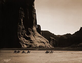
Canyon de Chelly National Monument was established on April 1, 1931, as a unit of the National Park Service. Located in northeastern Arizona, it is within the boundaries of the Navajo Nation and lies in the Four Corners region. Reflecting one of the longest continuously inhabited landscapes of North America, it preserves ruins of the indigenous tribes that lived in the area, from the Ancestral Puebloans to the Navajo. The monument covers 83,840 acres and encompasses the floors and rims of the three major canyons: de Chelly, del Muerto, and Monument. These canyons were cut by streams with headwaters in the Chuska Mountains just to the east of the monument. None of the land is federally owned. Canyon de Chelly is one of the most visited national monuments in the United States.

<span class="mw-page-title-main">Northern Arizona</span> Region of the US state of Arizona

Northern Arizona is an unofficial, colloquially-defined region of the U.S. state of Arizona. Generally consisting of Apache, Coconino, Mohave, Navajo, and Gila counties, the region is geographically dominated by the Colorado Plateau, the southern border of which in Arizona is called the Mogollon Rim.

<span class="mw-page-title-main">Walnut Canyon National Monument</span> Protected area in Coconino County, Arizona

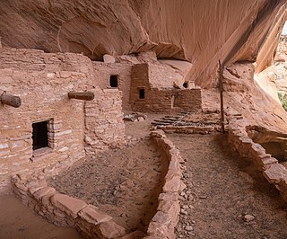
Walnut Canyon National Monument is a United States National Monument located about 10 mi (16 km) southeast of downtown Flagstaff, Arizona, near Interstate 40. The canyon rim elevation is 6,690 ft (2,040 m); the canyon's floor is 350 ft (110 m) lower. A 0.9 mi (1.4 km) long loop trail descends 185 ft (56 m) into the canyon passing 25 cliff dwelling rooms constructed by the Sinagua, a pre-Columbian cultural group that lived in Walnut Canyon from about 1100 to 1250 AD. Other contemporary habitations of the Sinagua people are preserved in the nearby Tuzigoot and Montezuma Castle national monuments.

<span class="mw-page-title-main">Navajo National Monument</span> National monument in Arizona, United States

Navajo National Monument is a National Monument located within the northwest portion of the Navajo Nation territory in northern Arizona, which was established to preserve three well-preserved cliff dwellings of the Ancestral Puebloan people: Keet Seel, Betatakin, and Inscription House. The monument is high on the Shonto plateau, overlooking the Tsegi Canyon system, west of Kayenta, Arizona. It features a visitor center with a museum, three short self-guided trails, two small campgrounds, and a picnic area.

<span class="mw-page-title-main">Pipe Spring National Monument</span> National monument in Arizona, United States

Pipe Spring National Monument is a United States National Monument located in the U.S. state of Arizona, rich with American Indian, early explorer, and Mormon pioneer history. Administered by the National Park Service, Pipe Spring was listed on the National Register of Historic Places on October 15, 1966, and the boundaries of the Pipe Spring National Monument Historic District were expanded in October 2000.

<span class="mw-page-title-main">Coconino National Forest</span> United States protected area in Arizona

The Coconino National Forest is a 1.856-million acre United States National Forest located in northern Arizona in the vicinity of Flagstaff, with elevations ranging from 2,600 feet to the highest point in Arizona at 12,633 feet. Originally established in 1898 as the "San Francisco Mountains National Forest Reserve", the area was designated a U.S. National Forest by Pres. Theodore Roosevelt on July 2, 1908, when the San Francisco Mountains National Forest Reserve was merged with lands from other surrounding forest reserves to create the Coconino National Forest. Today, the Coconino National Forest contains diverse landscapes, including deserts, ponderosa pine forests, flatlands, mesas, alpine tundra, and ancient volcanic peaks. The forest surrounds the towns of Sedona and Flagstaff and borders four other national forests; the Kaibab National Forest to the west and northwest, the Prescott National Forest to the southwest, the Tonto National Forest to the south, and the Apache-Sitgreaves National Forest to the southeast. The forest contains all or parts of nine designated wilderness areas, including the Kachina Peaks Wilderness, which includes the summit of the San Francisco Peaks. The headquarters are in Flagstaff. The Coconino National Forest consists of three districts: Flagstaff Ranger District, Mogollon Rim Ranger District, and Red Rock Ranger District, which have local ranger district offices in Flagstaff, Happy Jack, and Sedona.

<span class="mw-page-title-main">Sinagua</span> Pre-Columbian culture in Arizona, US

The Sinagua were a pre-Columbian culture that occupied a large area in central Arizona from the Little Colorado River, near Flagstaff, to the Verde River, near Sedona, including the Verde Valley, area around San Francisco Mountain, and significant portions of the Mogollon Rim country, between approximately 500 and 1425 CE.

<span class="mw-page-title-main">Palatki Heritage Site</span> Archaeological site in Coconino County, Arizona

The Palatki Heritage Site is an archaeological site and park located in the Coconino National Forest, near Sedona, in Arizona, United States at approximately 34 55' 4"N, 111 53' 59"W. In the Hopi language Palatki means 'red house'.

<span class="mw-page-title-main">Painted Desert Inn</span> United States historic place

Painted Desert Inn is a historic complex in Petrified Forest National Park, in Apache County, eastern Arizona. It is located off Interstate 40 and near the original alignment of historic U.S. Route 66, overlooking the Painted Desert.

<span class="mw-page-title-main">Elden Pueblo</span> Prehistoric feature in Coconino County, Arizona

Elden Pueblo was a prehistoric Native American village at the foot of Mount Elden near Flagstaff, Arizona. The pueblo is considered part of a major trading system. Various trade items, such as macaw skeletons from Mexico and shell jewelry from the coast of California, have been found throughout the site. The area is now protected and is used for research and educational purposes.

<span class="mw-page-title-main">Strawberry Crater</span> Cinder cone volcano in Coconino County, Arizona, US

Strawberry Crater is a cinder cone volcano, more than 1,000 feet (300 m) high, in the San Francisco volcanic field, 20 miles (32 km) north of Flagstaff, Arizona. It is along Forest Road 545 between the Wupatki National Monument and Sunset Crater National Monument in the Strawberry Crater Wilderness. The crater lies in a volcanic field at a base elevation of about 5,500 feet (1,700 m), and prominence heights of about 6,526 feet (1,989 m). The northwestern end of the crater is covered with lava flows, while the southern end is filled with low cinder cones. Several of the surrounding cones include the better known, taller and younger Sunset Crater in the adjacent Sunset Crater National Monument.

<span class="mw-page-title-main">Tuzigoot National Monument</span> Historic site in Yavapai County, Arizona, US

Tuzigoot National Monument preserves a 2- to 3-story pueblo ruin on the summit of a limestone and sandstone ridge just east of Clarkdale, Arizona, 120 feet (37 m) above the Verde River floodplain. The Tuzigoot Site is an elongated complex of stone masonry rooms that were built along the spine of a natural outcrop in the Verde Valley. The central rooms stand higher than the others and they appear to have served public functions. The pueblo has 110 rooms. The National Park Service currently administers 58 acres, within an authorized boundary of 834 acres.

<span class="mw-page-title-main">Black Falls, Arizona</span> Geographic feature on the Little Colorado River, Arizona

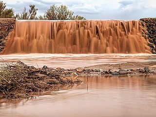
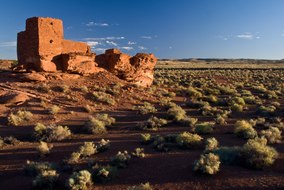
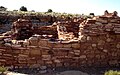
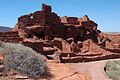
Black Falls is a natural basalt rock dam and significant crossing place on the Little Colorado River in Coconino County, Arizona near the Wupatki National Monument. The crossing lends its name to the sparsely populated Black Falls community of the Navajo Nation which is nearby.

<span class="mw-page-title-main">Puerco Ruin and Petroglyphs</span> NRHP Anasazi ruins in Arizona

Puerco Ruin and Petroglyphs are the ruins of a large Indian pueblo, which reached its peak around 1300 CE, containing over 100 rooms. It is the largest known archeological site within the Petrified Forest National Park.

References

  1. "Listing of acreage – December 31, 2011" (XLSX). Land Resource Division, National Park Service. Retrieved May 14, 2012. (National Park Service Acreage Reports)
  2. Proclamation 1721: Setting aside the Wupatki National Monument, Arizona  . December 9, 1924 via Wikisource.
  3. "NPS Annual Recreation Visits Report". National Park Service. Retrieved April 11, 2019.
  4. "History & Culture". Wupatki National Monument Arizona. National Park Service. January 4, 2018. Retrieved June 6, 2022.
  5. "National Register Information System". National Register of Historic Places . National Park Service. March 13, 2009.
  6. Catherine M. Cameron and Cherie L. Schieck (July 28, 1992). "National Register of Historic Places Registration: Wupatki National Monument".
  7. Snow, Dean (2010). Archaeology of Native North America. Prentice Hall. p. 134. ISBN   978-0136156864.
  8. Van Keuren, Scott; Neff, Hector; Agostini, Mark R. (December 2013). "Glaze-paints, technological knowledge, and ceramic specialization in the fourteenth-century Pueblo Southwest". Journal of Anthropological Archaeology. 32 (4): 675–690. doi:10.1016/j.jaa.2013.04.002. ISSN   0278-4165.
  9. "The Breathing Earth: Wupatki Blowholes" (PDF). nps.gov. National Park Service U.S. Department of the Interior. Archived from the original (PDF) on October 29, 2015. Retrieved May 8, 2015.
  10. "National Park Service". Wupatki National Monument. National Park Service. November 6, 2010.
  11. "Welcome to Anthropology Labs". jan.ucc.nau.edu. Retrieved April 8, 2012.
  12. Romme, William H.; Paul Whitefield, M.; Parker, Cynthia (February 2021). "Insights from recent fires into juniper savanna dynamics at Wupatki National Monument, Arizona, USA". Rangelands. 43 (1): 9–16. doi:10.1016/j.rala.2020.10.003. ISSN   0190-0528.
  13. "NOWData - NOAA Online Weather Data". National Oceanic and Atmospheric Administration. Retrieved December 12, 2022.
  14. "Summary of Monthly Normals 1991-2020". National Oceanic and Atmospheric Administration. Retrieved December 12, 2022.