Pacific Remote Islands Marine National Monument

Last updated
Pacific Remote Islands Marine National Monument
IUCN category V (protected landscape/seascape)
Green turtle Palmyra Atoll National Wildlife Refuge.jpg
Green sea turtle at Palmyra Atoll National Wildlife Refuge
LocationCentral Pacific Ocean
Area313,818,892 acres (1,269,980.00 km2) [1]
CreatedJanuary 6, 2009 (2009-January-06)
AdministratorJohn Klavitter, Superintendent, U.S. Fish and Wildlife Service
Website Pacific Remote Islands Marine National Monument
The previous (2011) boundaries of the Pacific Remote Islands Marine National Monument are outlined in light blue. Eez monument 4 6 2011.png
The previous (2011) boundaries of the Pacific Remote Islands Marine National Monument are outlined in light blue.
Soldierfish, Baker Island NWR Soldierfish, Baker Island NWR.jpg
Soldierfish, Baker Island NWR
Grey reef sharks, Pacific Remote Islands MNM Grey reef sharks,Pacific Remote Islands MNM.png
Grey reef sharks, Pacific Remote Islands MNM

The Pacific Remote Islands Marine National Monument is a group of unorganized, mostly unincorporated United States Pacific Island territories managed by the United States Fish and Wildlife Service of the United States Department of the Interior and the National Oceanic and Atmospheric Administration (NOAA) of the United States Department of Commerce. [2] [3] These remote refuges are "the most widespread collection of marine- and terrestrial-life protected areas on the planet under a single country's jurisdiction". [2] [3] They protect many endemic species including corals, fish, shellfish, marine mammals, seabirds, water birds, land birds, insects, and vegetation not found elsewhere. [4]

Contents

History

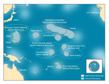
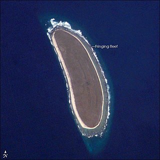
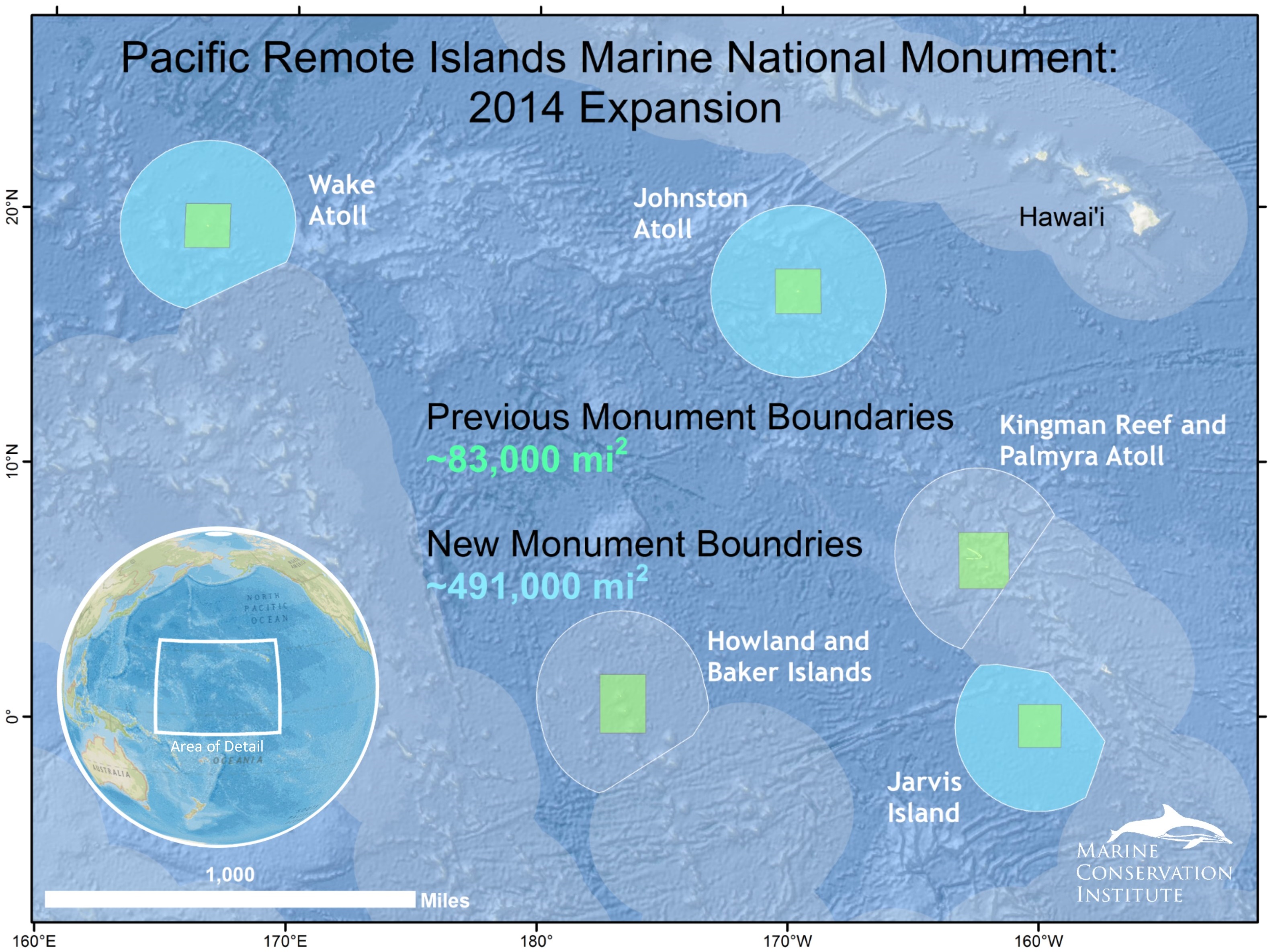
The Pacific Remote Islands Marine National Monument was proclaimed a national monument on January 6, 2009, by U.S. President George W. Bush [2] [3] and follows his June 6, 2006, creation of the Papahānaumokuākea Marine National Monument in the Northwestern Hawaiian Islands. The original area was about 83,000 square miles (210,000 km2). It was expanded on September 25, 2014 by U.S. President Barack Obama. The monument covers 490,343 square miles (1,269,980 km2), [1] spanning areas to the far south and west of Hawaii: Baker Island, Howland Island, Jarvis Island, Johnston Atoll, Kingman Reef, Palmyra Atoll, and Wake Island. At Baker Island, Howland Island, Jarvis Island, Kingman Reef, and Palmyra Atoll, the terrestrial areas, reefs, and waters out to 12 nautical miles (22 km; 14 mi) (radius) are part of the National Wildlife Refuge System. For Baker Island, Howland Island, Kingman Reef, and Palmyra Atoll, fishery-related activities seaward from the 12 nmi (22 km) refuge boundaries out to the 50 nmi (93 km) MNM boundary (about 100 nmi (190 km) square across) are managed by NOAA. For Jarvis Island, Johnston Atoll, and Wake Island, fishery-related activities seaward from the 12 nmi (22 km) refuge boundaries out to the 200 nmi (370 km) MNM boundary (U.S. EEZ waters) are managed by NOAA. The land areas at Wake and Johnston Atolls remain under the jurisdiction of the U.S. Air Force, but the waters from 0 to 12 nmi (22 km) are protected as units of the National Wildlife Refuge System. The entire monument is closed to commercial fishing and other resource extraction activities, such as deep sea mining. [5]

The monument includes endemic trees, grasses, and birds adapted to life at the equator; the rare sea turtles and whales and Hawaiian monk seals that visit Johnston Atoll; and high-quality coral reefs. U.S. federal law prohibits resource destruction or extraction, waste dumping, and commercial fishing in the monument areas. Research, free passage, and recreation are allowed.

On June 17, 2014, U.S. President Barack Obama proposed using his executive powers to expand the marine protected area to 782,000 square miles (2,030,000 km2). Sport fishing is exempt and public comments were solicited. [6] He then signed a proclamation on September 25, 2014, expanding the monument to six times its original size, resulting in 490,343 square miles (1,269,982 square kilometers) [1] of protected area around these tropical islands and atolls in the south-central Pacific Ocean. Expanding the monument protected the deep coral reefs, seamounts, and marine ecosystems unique to this part of the world, which are also among the most vulnerable areas to the impacts of climate change and ocean acidification. [5] Specifically, it expanded the boundaries to the 200 nautical-mile outer limit of the U.S. EEZ around Wake Island, Johnston Atoll, and Jarvis Island, while leaving in place the 50 nautical-mile boundaries for Kingman Reef and Palmyra Atoll and Howland and Baker Islands created by the 2009 proclamation. [7] [8]

In September 2017, Trump Administration U.S. Interior Secretary Ryan Zinke recommended that the boundaries of the monument be reduced by an unspecified amount. [9] By the end of his term in office, in January 2021, former President Trump had not followed this recommendation.

In March 2023, President Biden directed the Secretary of Commerce to consider making the monument and additional areas within the U.S. EEZ a National Marine Sanctuary, as well as to study a renaming of the monument, its islands, and their related national wildlife refuges. [10]

Geography

Location and area

The following islands form the basis of the Pacific Remote Islands Marine National Monument:

South of the monument is the Phoenix Islands Protected Area, with a size of 408,250 km2 (157,630 sq mi), which was created by the government of Kiribati. [11]

Climate

Susan White, Operations Superintendent, holding a young red-footed booby, 2014 Susan White, Monument Superintendent, Pacific MNM.png
Susan White, Operations Superintendent, holding a young red-footed booby, 2014

Because the islands are scattered throughout the ocean, the climate is different on each island. Baker, Howland, and Jarvis Islands have an equatorial climate, with scant rainfall, constant wind, and burning sun. Johnston Atoll and Kingman Reef have a tropical climate, but are generally dry, with consistent northeast trade winds with little seasonal temperature variation. Palmyra Atoll has a hot, equatorial climate. Because the atoll is located within the low pressure area of the Intertropical Convergence Zone where the northeast and southeast trade winds meet, it is extremely wet with between 4,000–5,000 mm (160–200 in) of rainfall each year. [4]

Effects of climate change

A recent study in the journal Climatic Change, suggests the expanded reserve could make pelagic fish populations in the Pacific more resilient to ocean warming. [12] Researchers found that by 2060, warmer temperatures will attract skipjack tuna from the Western Pacific to the protected waters of the Monument, away from areas that are heavily fished. [8]

Population

Although the islands have no permanent residents, the seven islands that make up the Pacific Remote Islands are stepping stones that connect Hawaii to Micronesia, and other Polynesian sea voyaging cultures. The voyage from Hawaii to neighboring Marshall Islands once included a stop at Johnston Atoll. Wake Atoll is geographically, culturally, and historically linked to the people who live in the Republic of the Marshall Islands. Kingman, Palmyra, Jarvis, Howland, and Baker are connected to the Republic of Kiribati. Voyaging and culture link all of these islands. [13]

Wake has a current transient population of ca. 125 military personnel and contractors. Johnston Atoll had a peak population of 1,100 military and civilian contractor personnel in 2000, but it was evacuated by 2007. From 2010 through 2021, volunteer biologists lived and worked on the island in groups of 5, but since May 2021 the island has had no permanent inhabitants. Four to twenty Nature Conservancy and U.S. Fish and Wildlife staff live at Palmyra Atoll at any one time. The four other islands are usually uninhabited.

Public entry to the islands is by special-use permit from U.S. Fish and Wildlife Service, and is generally restricted to scientists and educators. [4] Only Wake Island and Palmyra Atoll have serviceable runways; Jarvis, Johnston Atoll, Baker, and Howland Islands had airstrips in earlier times but they have long been abandoned and are no longer operational.

See also

Related Research Articles

<span class="mw-page-title-main">Baker Island</span> Uninhabited Pacific atoll administered by the United States

Baker Island, formerly known as New Nantucket, is an uninhabited atoll just north of the Equator in the central Pacific Ocean about 3,090 km (1,920 mi) southwest of Honolulu. The island lies almost halfway between Hawaii and Australia. Its nearest neighbor is Howland Island, 42 mi (68 km) to the north-northwest; both have been claimed as territories of the United States since 1857, though the United Kingdom considered them part of the British Empire between 1897 and 1936.

<span class="mw-page-title-main">Howland Island</span> US-controlled coral island in the central Pacific Ocean

Howland Island is an uninhabited coral island located just north of the equator in the central Pacific Ocean, about 1,700 nautical miles (3,100 km) southwest of Honolulu. The island lies almost halfway between Hawaii and Australia and is an unorganized, unincorporated territory of the United States. Together with Baker Island it forms part of the Phoenix Islands. For statistical purposes, Howland is grouped as one of the United States Minor Outlying Islands. The island has an elongated cucumber-shape on a north–south axis, 1.40 by 0.55 miles, and covers 1 square mile.

<span class="mw-page-title-main">Jarvis Island</span> Coral island in the South Pacific Ocean

Jarvis Island is an uninhabited 4.5 km2 (1.7 sq mi) coral island located in the South Pacific Ocean, about halfway between Hawaii and the Cook Islands. It is an unincorporated, unorganized territory of the United States, administered by the United States Fish and Wildlife Service of the United States Department of the Interior as part of the National Wildlife Refuge system. Unlike most coral atolls, the lagoon on Jarvis is wholly dry.

<span class="mw-page-title-main">Johnston Atoll</span> United States Minor Outlying Islands

Johnston Atoll is an unincorporated territory of the United States, administered by the United States Fish and Wildlife Service (USFWS). It is a National Wildlife Refuge and part of the Pacific Remote Islands Marine National Monument. It is closed to public entry, and limited access for management needs is only granted by Letter of Authorization from the United States Air Force and a Special Use Permit from the U.S. Fish and Wildlife Service.

<span class="mw-page-title-main">Kingman Reef</span> Reef and unincorporated U.S. territory in the Pacific Ocean

Kingman Reef is a largely submerged, uninhabited, triangle-shaped reef, geologically an atoll, 9.0 nmi (20 km) east-west and 4.5 nmi (8 km) north-south, in the North Pacific Ocean, roughly halfway between the Hawaiian Islands and American Samoa. It has an area of 3 hectares and is one of the unincorporated territories of the United States in Oceania. The reef is administered by the United States Fish and Wildlife Service as the Kingman Reef National Wildlife Refuge.

<span class="mw-page-title-main">Midway Atoll</span> North Pacific Atoll of the United States Minor Outlying Islands

Midway Atoll is a 2.4 sq mi (6.2 km2) atoll in the North Pacific Ocean. Midway Atoll is an insular area of the United States and is an unorganized and unincorporated territory. The largest island is Sand Island, which has housing and an airstrip. Immediately to the east of Sand Island across the narrow Brooks Channel is Eastern Island, which is uninhabited and no longer has any facilities. Forming a rough, incomplete circle around the two main islands and creating Midway Lagoon is Spit Island, a narrow reef.

<span class="mw-page-title-main">Palmyra Atoll</span> Pacific atoll and unorganized incorporated U.S. territory

Palmyra Atoll, also referred to as Palmyra Island, is one of the Northern Line Islands. It is located almost due south of the Hawaiian Islands, roughly one-third of the way between Hawaii and American Samoa. North America is about 3,300 miles northeast and New Zealand the same distance southwest, placing the atoll at the approximate center of the Pacific Ocean. The land area is 4.6 sq mi (12 km2), with about 9 miles (14 km) of sea-facing coastline and reef. There is one boat anchorage known as West Lagoon, accessible from the sea by a narrow artificial channel.

<span class="mw-page-title-main">United States Minor Outlying Islands</span> Statistical designation of small islands of the United States

The United States Minor Outlying Islands is a statistical designation defined by the International Organization for Standardization's ISO 3166-1 code. The entry code is ISO 3166-2:UM. The minor outlying islands and groups of islands consist of eight United States insular areas in the Pacific Ocean and one in the Caribbean Sea.

<span class="mw-page-title-main">Insular area</span> U.S. territory that is neither a U.S. state nor the District of Columbia

In the law of the United States, an insular area is a U.S.-associated jurisdiction that is not part of the 50 states or the District of Columbia. This includes fourteen U.S. territories administered under U.S. sovereignty, as well as three sovereign states each with a Compact of Free Association with the United States. The term also may be used to refer to the previous status of the Philippine Islands and the Trust Territory of the Pacific Islands when it existed.

<span class="mw-page-title-main">Northwestern Hawaiian Islands</span> Small islands and atolls in Hawaii

The Northwestern Hawaiian Islands or Leeward Hawaiian Islands are a series of islands and atolls in the Hawaiian island chain located northwest of the islands of Kauai and Niʻihau. Politically, they are all part of Honolulu County in the U.S. state of Hawaii, except Midway Atoll, which is a territory distinct from the State of Hawaii, and grouped as one of the United States Minor Outlying Islands. The United States Census Bureau defines this area, except Midway, as Census Tract 114.98 of Honolulu County. Its total land area is 3.1075 square miles (8.048 km2). All the islands except Nihoa are north of the Tropic of Cancer, making them the only islands in Hawaii that lie outside the tropics.

<span class="mw-page-title-main">Pearl and Hermes Atoll</span> Atoll of Hawaii

The Pearl and Hermes Atoll, also known as Pearl and Hermes Reef, is part of the Northwestern Hawaiian Islands, a group of small islands and atolls that form the farthest northwest portion of the Hawaiian island chain. The atoll consists of a variable number of flat and sandy islets, typically between five and seven. More were noted in historical sources but have since been lost to erosion and rising sea levels.

<span class="mw-page-title-main">Pacific coast</span> Part of a nations coast bordering the Pacific Ocean

Pacific coast may be used to reference any coastline that borders the Pacific Ocean.

<span class="mw-page-title-main">Asia-Pacific</span> Geographical and geopolitical region in Asia and Oceania

Asia-Pacific (APAC) is the part of the world near the western Pacific Ocean. The Asia-Pacific region varies in area depending on the context, but it often includes countries in East Asia, Southeast Asia, and Oceania that border the Pacific Ocean. South Asia, Mongolia, Myanmar, and the Russian Far East are generally included in a wider Asia-Pacific region.

<span class="mw-page-title-main">Papahānaumokuākea Marine National Monument</span> Protected region of ocean and islands

The Papahānaumokuākea Marine National Monument (PMNM) is a World Heritage listed U.S. National Monument encompassing 583,000 square miles (1,510,000 km2) of ocean waters, including ten islands and atolls of the Northwestern Hawaiian Islands. It was created in June 2006 with 140,000 square miles (360,000 km2) and expanded in August 2016 by moving its border to the limit of the exclusive economic zone, making it one of the world's largest protected areas. It is internationally known for its cultural and natural values as follows:

The area has deep cosmological and traditional significance for living Native Hawaiian culture, as an ancestral environment, as an embodiment of the Hawaiian concept of kinship between people and the natural world, and as the place where it is believed that life originates and to where the spirits return after death. On two of the islands, Nihoa and Mokumanamana, there are archaeological remains relating to pre-European settlement and use. Much of the monument is made up of pelagic and deepwater habitats, with notable features such as seamounts and submerged banks, extensive coral reefs and lagoons.

The United States Miscellaneous Pacific Islands is an obsolete term used to collectively describe Baker Island, Howland Island, Jarvis Island, Kingman Reef, and Palmyra Atoll, all of them territories in the Pacific Ocean controlled by the United States by way of the Guano Islands Act.

<span class="mw-page-title-main">Outline of Oceania</span> Overview of and topical guide to Oceania

The following outline is provided as an overview and topical guide to Oceania.

<span class="mw-page-title-main">Joint Task Force-Homeland Defense</span> Military unit

Source: JTF-HD PAO

<span class="mw-page-title-main">Central Polynesian tropical moist forests</span> Terrestrial ecoregion in central Polynesia

The Central Polynesian tropical moist forests is a tropical and subtropical moist broadleaf forests ecoregion in Polynesia. It includes the northern group of the Cook Islands, the Line Islands in Kiribati, and Johnston Atoll, Jarvis Island, Palmyra Atoll, and Kingman Reef which are possessions of the United States.

<span class="mw-page-title-main">Coral reefs of Kiribati</span> Pacific Ocean Island chain

The Coral reefs of Kiribati consists of 32 atolls and one raised coral island, Banaba, which is an isolated island between Nauru and the Gilbert Islands. The islands of Kiribati are dispersed over 3.5 million km2 (1.4 million sq mi) of the Pacific Ocean and straddle the equator and the 180th meridian, extending into the eastern and western hemispheres, as well as the northern and southern hemispheres. 21 of the 33 islands are inhabited. The groups of islands of Kiribati are:

References

  1. 1 2 3 "MPAtlas". Archived from the original on 6 October 2014. Retrieved 16 October 2014.
  2. 1 2 3 "Presidential Proclamation 8336" (PDF). fws.gov. Archived (PDF) from the original on 1 October 2017. Retrieved 23 April 2018.
  3. 1 2 3 Weekly Compilation of Presidential Documents: Monday, January 12, 2009 Volume 45—Number 1, Page 14 Archived March 1, 2009, at the Wayback Machine
  4. 1 2 3 "United States Pacific Island Wildlife Refuges". CIA World Factbook. Archived from the original on 2006-06-29.
  5. 1 2 Whitehouse.gov (25 Sept 2014) "FACT SHEET: President Obama to Designate Largest Marine Monument in the World Off-Limits to Development". Retrieved 25 Sept 2014. "FACT SHEET: President Obama to Designate Largest Marine Monument in the World Off-Limits to Development". whitehouse.gov . 24 September 2014. Archived from the original on 2017-01-20. Retrieved 2014-09-29 via National Archives.
  6. Eilperin, Juliet. (17 June 2014) "Obama proposes vast expansion of Pacific Ocean sanctuaries for marine life". Washington Post. Retrieved 17 June 2014. "Obama proposes vast expansion of Pacific Ocean marine sanctuary - the Washington Post". The Washington Post . Archived from the original on 2017-10-13. Retrieved 2017-09-07.
  7. "U.S. Creates Largest Protected Area in the World, 3X Larger Than California". National Geographic News. 2014-09-26. Retrieved 2021-02-14.
  8. 1 2 C. Pala, Will 'lazy' fish benefit most from new U.S. marine megareserve?, Sept. 24, 2014, sciencemag.org/news/2014/09/will-lazy-fish-benefit-most-new-marine-megareserve
  9. Eilperin, Juliet (2017-09-17). "Shrink at least 4 national monuments and modify a half-dozen others, Zinke tells Trump". Washington Post. ISSN   0190-8286. Archived from the original on 2017-09-18. Retrieved 2017-09-18.
  10. "Memorandum on Conserving the Natural and Cultural Heritage of the Pacific Remote Islands". The White House. 2023-03-24. Retrieved 2023-03-27.
  11. "Phoenix Islands Protected Area (". Conservation International. 2020. Retrieved 29 March 2021.
  12. Lehodey, Patrick; Senina, Inna; Calmettes, Beatriz; Hampton, John; Nicol, Simon (2013-07-01). "Modelling the impact of climate change on Pacific skipjack tuna population and fisheries". Climatic Change. 119 (1): 95–109. Bibcode:2013ClCh..119...95L. doi:10.1007/s10584-012-0595-1. hdl: 10.1007/s10584-012-0595-1 . ISSN   1573-1480. S2CID   153460718.
  13. "Connecting Conservation and Culture in Oceania". www.taotaotasi.com. Archived from the original on 22 February 2018. Retrieved 23 April 2018.