
The United Nations Convention on the Law of the Sea (UNCLOS), also called the Law of the Sea Convention or the Law of the Sea Treaty, is an international agreement that establishes a legal framework for all marine and maritime activities. As of May 2023, 168 countries and the European Union are parties.

Territorial waters are informally an area of water where a sovereign state has jurisdiction, including internal waters, the territorial sea, the contiguous zone, the exclusive economic zone, and potentially the extended continental shelf. In a narrower sense, the term is often used as a synonym for the territorial sea.

An exclusive economic zone (EEZ), as prescribed by the 1982 United Nations Convention on the Law of the Sea, is an area of the sea in which a sovereign state has exclusive rights regarding the exploration and use of marine resources, including energy production from water and wind. EEZ does not define the ownership of any maritime features within the EEZ.
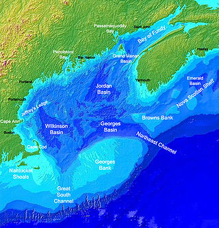
Georges Bank is a large elevated area of the sea floor between Cape Cod, Massachusetts, and Cape Sable Island, Nova Scotia (Canada). It separates the Gulf of Maine from the Atlantic Ocean.
The Minerals Management Service (MMS) was an agency of the United States Department of the Interior that managed the nation's natural gas, oil and other mineral resources on the outer continental shelf (OCS).
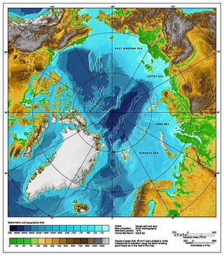
The Arctic consists of land, internal waters, territorial seas, exclusive economic zones (EEZs) and international waters above the Arctic Circle. All land, internal waters, territorial seas and EEZs in the Arctic are under the jurisdiction of one of the eight Arctic coastal states: Canada, Denmark, Finland, Iceland, Norway, Russia, Sweden and the United States. International law regulates this area as with other portions of Earth.
The United States Deep Water Royalty Relief Act (DWRRA) implemented a royalty-relief program that relieves eligible leases from paying royalties on defined amounts of deep-water petroleum production over Federal Outer Continental Shelf lands. After its expiration in 2000, the DWRRA was redefined and extended to promote continued interest in deep water. The Minerals Management Service (MMS) defines a "deep-water" lease as having a minimum water depth of 200 meters.

Rigs-to-Reefs (RTR) is the practice of converting decommissioned offshore oil and petroleum rigs into artificial reefs. Such biotic reefs have been created from oil rigs in the United States, Brunei and Malaysia. In the United States, where the practice started and is most common, Rigs-to-Reefs is a nationwide program developed by the former Minerals Management Service (MMS), now Bureau of Safety and Environmental Enforcement (BSEE), of the U.S. Department of the Interior.
Tidelands are the territory between the tide line of sea coasts, and lands lying under the sea beyond the low-water limit of the tide, considered within the territorial waters of a nation. The United States Constitution does not specify whether ownership of these lands rests with the federal government or with individual states. Originally little commercial value was attached to tidelands, so ownership was never firmly established, but the coastal states generally proceeded as if they were the owners. Some states, such as Mississippi, directly administer these lands under the public trust doctrine.

Within the petroleum industry, proven crude oil reserves in the United States were 44.4 billion barrels (7.06×10⁹ m3) of crude oil as of the end of 2021, excluding the Strategic Petroleum Reserve.

Offshore oil and gas in the United States provides a large portion of the nation’s oil and gas supply. Large oil and gas reservoirs are found under the sea offshore from Louisiana, Texas, California, and Alaska. Environmental concerns have prevented or restricted offshore drilling in some areas, and the issue has been hotly debated at the local and national levels.

Offshore drilling for oil and gas on the Atlantic coast of the United States took place from 1947 to the early 1980s. Oil companies drilled five wells in Atlantic Florida state waters and 51 exploratory wells on federal leases on the outer continental shelf of the Atlantic coast. None of the wells were completed as producing wells. All the leases have now reverted to the government.

The Submerged Lands Act of 1953 is a U.S. federal law that recognized the title of the states to submerged navigable lands within their boundaries at the time they entered the Union. They include navigable waterways, such as rivers, as well as marine waters within the state's boundaries, generally three geographical miles from the coastline.
The Bureau of Ocean Energy Management (BOEM) is an agency within the United States Department of the Interior, established in 2010 by Secretarial Order. The oil, gas, and renewable energy related management functions formerly under the purview of the Minerals Management Service (MMS) were delegated to the BOEM and its sister agency, The Bureau of Safety and Environmental Enforcement. Specifically, BOEM is involved in resource evaluation, planning, and leasing.

The Bureau of Safety and Environmental Enforcement is an agency under the United States Department of the Interior. Established in 2011, BSEE is the lead agency in charge of improving safety and ensuring environmental protection relating to the offshore energy industry, mainly natural gas and oil, on the United States Outer Continental Shelf (OCS). The agency exercises the safety and environmental enforcement functions formerly under the Minerals Management Service including the authority to inspect, investigate, summon witnesses and produce evidence, levy penalties, cancel or suspend activities, and oversee safety, response, and removal preparedness.
The equidistance principle, or principle of equidistance, is a legal concept in maritime boundary claims that a nation's maritime boundaries should conform to a median line that is equidistant from the shores of neighboring nations. The concept was developed in the process of settling disputes in which the borders of adjacent nations were located on a contiguous continental shelf:
An equidistance line is one for which every point on the line is equidistant from the nearest points on the baselines being used. The equidistance principle is a methodology that has been endorsed by the United Nations Convention on the Law of the Sea but predates that treaty and has been used by the Supreme Court of the United States, states, and nations to establish boundaries equitably.

Cynthia L. Quarterman is an American lawyer and engineer, former Director of the Minerals Management Service and Administrator of the Pipeline and Hazardous Materials Safety Administration from 2009 until her resignation on October 4, 2014.
The Outer Continental Shelf Transboundary Hydrocarbon Agreements Authorization Act is a bill that would approve a February 20, 2012 agreement between the United States of America and Mexico about the development of oil and gas natural resources in the Outer Continental Shelf in the Gulf of Mexico near where the two countries share a border. The bill also establishes some of the rules and procedures for enacting this treaty. It was introduced into the United States House of Representatives during the 113th United States Congress.
The Offshore Energy and Jobs Act is a bill that was introduced into the United States House of Representatives during the 113th United States Congress. The Offshore Energy and Jobs Act would revise existing law governing the leasing, operation, and development of oil and natural gas resources available in the Outer Continental Shelf (OCS). The bill is primarily supported by Republicans and is opposed by President Barack Obama.
The Lowering Gasoline Prices to Fuel an America That Works Act of 2014 is a bill that would revise existing laws and policies regarding the development of oil and gas resources on the Outer Continental Shelf. The bill is intended to increase domestic energy production and lower gas prices.
