
New California is a census-designated place in central Jerome Township, Union County, Ohio, United States. It is located at 40°09′22″N83°14′12″W, at the intersection of U.S. Route 42 and Industrial Parkway, just south of 42's intersection with U.S. Route 33.

Belvedere is an unincorporated community in Wayne Township, Jefferson County, Ohio, United States. It is located between Bloomingdale and Wintersville along U.S. Route 22 at its intersection with "Old U.S. Route 22", at 40°21′28″N80°45′54″W.

Irwin is an unincorporated community in southwestern Union Township, Union County, Ohio, United States. It is located at 40°07′21″N83°29′22″W, at the intersection of Ohio State Route 4 and 161. Irwin has a post office which serves the surrounding area, including the community of Rosedale.

Buckeye is an unincorporated community in Garrard County, Kentucky, United States. It lies along Route 39 northeast of the city of Lancaster, the county seat of Garrard County. Its elevation is 955 feet (291 m).

Conroy is an unincorporated community and census-designated place (CDP) in central Iowa County, Iowa, United States. It lies along local roads southeast of the city of Marengo, the county seat of Iowa County. Its elevation is 879 feet (268 m). Conroy has a post office with the ZIP code of 52220, which opened on 5 January 1885. As of the 2010 census the population was 259.

Concord is an unincorporated community in Sussex County, Delaware, United States. Concord is located along Delaware Route 20 east of Seaford.

Arlington is a census-designated place (CDP) in southeastern Carbon County, Wyoming, United States. The population was 25 at the 2010 census.

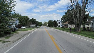
Lafayette is a census-designated place in the center of Deer Creek Township, Madison County, Ohio, United States. It is located at 39°56′15″N83°24′24″W, along U.S. Route 40, just west of its intersection with U.S. Route 42.
Pancoastburg is an unincorporated community and census-designated place (CDP) in Madison Township, Fayette County, Ohio, United States. It is located at 39°37′28″N83°15′56″W, along Ohio State Route 207, about 6 miles (10 km) south of Mount Sterling. As of the 2010 census the population of Pancoastburg was 87.
Blackfork Junction is an unincorporated community in Jefferson Township, Jackson County, Ohio.

Altoona is an unincorporated community in Coal Township, Jackson County, Ohio, United States. It is located east of Coalton on Ohio State Route 93.
Arbela is an unincorporated community in Washington Township, Union County, Ohio, United States. It is located at 40°28′54″N83°24′25″W, at the intersection of Ohio State Route 739 and Cunningham-Arbela Road.
Keystone is an unincorporated community in Bloomfield Township, Jackson County, Ohio, United States. It is located south of the city of Jackson, at the intersection of Franklin Valley Road and Keystone Station Road, at 38°59′17″N82°36′33″W.
Rempel is an unincorporated community in Madison Township, Jackson County, Ohio, United States. It is located southeast of Jackson at the intersection of C H and D Road, Rempel Road, and Vega Road, at 38°56′10″N82°31′16″W.
Brocks Corner is an unincorporated community in Jackson Township, Jackson County, Ohio, United States. It is located northwest of Jackson at the intersection of U.S. Route 35 and Bronx Corner Road.
Goldsboro is an unincorporated community in Coal Township, Jackson County, Ohio, United States. It is located west of Wellston on Ohio State Route 93, between Comet and Glen Roy.
Monroe is an unincorporated community in Jefferson Township, Jackson County, Ohio, United States. It is located southwest of Oak Hill on Ohio State Route 140 between Blackfork Junction and Firebrick, at 38°51′23″N82°37′45″W.
Roads is an unincorporated community in Milton Township, Jackson County, Ohio, United States. It is located south of Wellston at the intersection of Ohio State Route 327 and Ohio State Route 124, at 39°04′52″N82°32′17″W.
Altamont is an unincorporated community in Steubenville Township, Jefferson County, Ohio, United States. It is located south of Steubenville and just east of Hillsboro along Wilson Avenue, at 40°20′00″N80°37′03″W.
Lynn is an unincorporated community and defunct place in Pleasant Township, Marion County, Ohio, United States. It is located about 3 miles (4.8 km) northwest of Waldo along Newmans-Cardington Road, at 40°29′56″N83°06′26″W.

