Buena Vista (Miami)

Last updated
Buena Vista
Miami neighborhoodsmap.png
Buena Vista neighborhood within the City of Miami
Coordinates: 25°48′47.3″N80°11′34.57″W / 25.813139°N 80.1929361°W / 25.813139; -80.1929361
Country United States
State Florida
County Miami-Dade County
City City of Miami
Settled1892
Annexed into the City of Miami1924
Subdistricts of Buena Vista
Neighborhoods list
  • Buena Vista East Historic District
Government
  City of Miami CommissionerRichard Dunn
  Miami-Dade CommissionerAudrey Edmonson
   House of Representatives Daphne Campbell (D) and Cynthia A. Stafford (D)
   State Senate Larcenia Bullard (D), and Oscar Braynon (D)
   U.S. House Frederica Wilson (D)
Population
 (2010)
  Total9,058
  Density9,168/sq mi (3,540/km2)
Time zone UTC-05 (EST)
ZIP Code
33127, 33137
Area code(s) 305, 786

Buena Vista is a neighborhood in Miami, Florida, United States. It is located south of Little Haiti, north of the Miami Design District. [1] [2]

Contents

Buena Vista is primarily a residential neighborhood with historic single-family homes primarily from the 1920s. The Buena Vista East Historic District is located in Buena Vista, and includes some of the oldest homes in the neighborhood.

History

In the 1890s, Buena Vista was a small village, and its founding and growth paralleled Miami's. During the Land Boom of the 1920s, the area was developed as the Biltmore and Shadowlawn subdivisions. Originally home to many Florida cracker immigrants from Georgia and North Carolina, the neighborhood soon became popular with the owners of nearby businesses. The houses reflect their original owners' rising social status and include examples of Mediterranean Revival, Mission, Craftsman, and Art Deco style residences. [3]

Buena Vista, Lemon City, and Little River were founded before the turn of the 19th century and represent some of the early settlements in Miami-Dade County. The area known as Buena Vista was once a small village adjoining, but not within the corporate limits of Miami proper. Although preceded in age by pioneer Lemon City, a town located north, the village of Buena Vista dates its birth, development, and growth along with Miami’s. The founding of Buena Vista dates back to the days when the immense rock ridge extending between the Atlantic Ocean and the Florida Everglades was covered by a dense pine forest. The earliest history of the village is recorded in a survey made by government surveyors, and the locations of tracts are to this date still founded on this early document.

Northwestward aerial of the FEC Buena Vista yard in 1928, now the Midtown Miami development. Buena Vista yard, 1928.png
Northwestward aerial of the FEC Buena Vista yard in 1928, now the Midtown Miami development.

The land which became Buena Vista originally was part of the homesteads of William Henry Gleason and E.L. White. Gleason, a prominent and somewhat notorious figure in early Miami-Dade County politics, arrived in Miami after the Civil War, and he was elected lieutenant governor of Florida. He left the area in 1876 but retained his homestead for several years, eventually giving it to his son. As early as 1892, E.L. White homesteaded the area from North 41st Street to 54th Street between West 2nd Avenue and East 2nd Avenue. This area includes the Biltmore and Shadowlawn subdivisions, which today make up the Buena Vista East Historic District.

The arrival of the railroad in 1896 marked the end of an era for the pioneer bayfront village of Lemon City, which had enjoyed tremendous importance to the Miami area by virtue of its docks. The train brought supplies to the rest of Dade County and lured people from the bayfront community to Miami and its outlying areas. The Lemon City depot, built in 1896, drew business west from the bay, and the village of Buena Vista gradually developed. One of the early subdivisions in the Buena Vista areas was the Buena Vista Biscayne Badger Club, which was developed in 1910 as a bayfront community with a private water plant, streets, and a park with recreation dock on the bay. However, it was inland where the village took shape. By 1910, suburban Buena Vista could boast of one hotel known as the Courley House, its very own railroad depot on the Florida East Coast Railway line, a small post office building, groves of tropical fruits, a fruit-packing house, a grocery store, and the Holy Cross Episcopal Church.

Other prominent citizens acquired land in Buena Vista. Among them was the millionaire Charles Deering, who purchased a large tract of bayfront land east of the railroad, in the area now known as the Upper Eastside. This land is where the Baypoint neighborhood is now located. Much of the area fronting the bay was naturally wooded, and Deering created an arboretum and sanctuary for birds and animals. There were no public roadways in the area east of the railroad, and because Deering strongly opposed the opening of such streets, the area was preserved in its pristine state for many years.

As the population of Miami grew between the late 1910s through the Boom era of the early 1920s, new areas reached northward along the old Dixie Highway (NE 2nd Avenue) and Avenue D (N. Miami Avenue), which extended northward from NE 36th Street. The northern city limit of Miami was moved to NE 38th Street, and this took in a part of Buena Vista. On August 4, 1924, the town of Buena Vista was incorporated, and with the other incorporated areas of Coconut Grove and Silver Bluff, it was annexed to the City of Miami the following year. [4]

Geography

It is located at 25°48′47″N80°11′31″W / 25.813°N 80.192°W / 25.813; -80.192 , with an elevation 13 feet (4.0 m), making it one of the higher areas in the city. [5] It is bounded by NW 54th Street to the north, I-195 to the south, I-95 to the west, and Biscayne Boulevard to the east. [6]

Buena Vista East Historic District

The Buena Vista East Historic District is located on the eastern side of Buena Vista, and is bound between NE 2nd Avenue and Miami Avenue from NE 42nd Street to NE 48th Street. [7]

Demographics

As of 2000, the population of Buena Vista was 11,290 people. The zip codes for Buena Vista include 33127 and 33137. The area covers 1.265 square miles (3.28 km2). As of 2000, there were 5,396 males and 5,894 females. The median age for males were 31.5 years old, while the median age for females were 36.9 years old. The average household size had 3.2 people, while the average family size had 3.8 members. The percentage of married-couple families (among all households) was 31.3%, while the percentage of married-couple families with children (among all households) was 14.7%, and the percentage of single-mother households (among all households) was 20.7%. The percentage of never-married males 15 years old and over was 19.4%, while the percentage of never-married females 15 years old and over was 18.5%. [6]

As of 2000, the percentage of people that speak English not well or not at all made up 13.5% of the population. The percentage of residents born in Florida was 41.5%, the percentage of people born in another U.S. state was 16.8%, and the percentage of native residents but born outside the U.S. was 4.3%, while the percentage of foreign born residents was 37.4%. [6]

Education

Miami-Dade County Public Schools operates area public schools:

Elementary schools


Middle schools

High schools

See also

Related Research Articles

<span class="mw-page-title-main">El Portal, Florida</span> Village in Florida

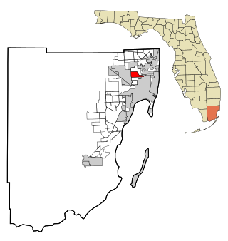
El Portal is a village in Miami-Dade County, Florida, United States. The name is derived from the Spanish term for "the gate", after two wooden gates that once stood as a gateway to the village. El Portal was originally annexed into the city of Miami in 1925. With the arrival of the Great Depression, Miami gave up its jurisdiction, and El Portal was incorporated as its own village in 1937. The village is part of the Miami metropolitan area of South Florida. As of the 2020 census, the population of El Portal was 1,986, down from 2,325 in 2010.

<span class="mw-page-title-main">Gladeview, Florida</span> Census-designated place in Florida

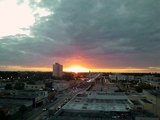
Gladeview is a census-designated place (CDP) in Miami-Dade County, Florida, United States. It is part of the Miami metropolitan area of South Florida. The population was 14,927 at the 2020 census, up from 11,535 in 2010.

<span class="mw-page-title-main">North Miami Beach, Florida</span> City in Florida

North Miami Beach is a city in Miami-Dade County, Florida, United States. The city is part of the Miami metropolitan area of South Florida. Originally named "Fulford-by-the-Sea" in 1926 after Captain William H. Fulford of the U.S. Coast Guard, the city was renamed "North Miami Beach" in 1931. The population was 43,676 at the 2020 US census.

<span class="mw-page-title-main">West Little River, Florida</span> CDP in Miami-Dade County, Florida, US

West Little River is a census-designated place (CDP) in Miami-Dade County, Florida, United States. It is part of the Miami metropolitan area of South Florida. The population was 34,128 at the 2020 census.

<span class="mw-page-title-main">Coconut Grove</span> Neighborhood of Miami, Florida, United States

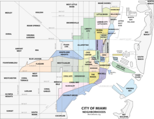
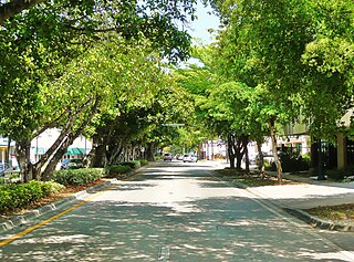
Coconut Grove, also known colloquially as The Grove, is an affluent and the oldest continuously inhabited neighborhood of Miami in Miami-Dade County, Florida. The neighborhood is roughly bounded by North Prospect Drive to the south, LeJeune Road to the west, South Dixie Highway and Rickenbacker Causeway to the north, and Biscayne Bay to the east. It is south of the neighborhoods of Brickell and The Roads and east of Coral Gables. The neighborhood's name has been sometimes spelled "Cocoanut Grove" but the definitive spelling "Coconut Grove" was established when the city was incorporated in 1919.

<span class="mw-page-title-main">Little Havana</span> Neighborhood of Miami, Florida, US

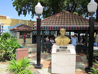
Little Havana is a neighborhood of Miami, Florida, United States. Home to many Cuban exiles, as well as many immigrants from Central and South America, Little Havana is named after Havana, the capital and largest city in Cuba.

<span class="mw-page-title-main">Allapattah</span> Neighborhood of Miami in Miami-Dade County, Florida, United States

Allapattah is a neighborhood, located mostly in the city of Miami, Florida in metropolitan Miami. As of May 2011, the county-owned portion of Allapattah, from State Road 9 to LeJeune Road, is being annexed by the city proper.

<span class="mw-page-title-main">Little Haiti</span> Neighborhood of Miami in Miami-Dade County, Florida, United States

Little Haiti, is a neighborhood of Miami, Florida, United States. It is known historically as Lemon City, Little River and Edison. It is home to Haitian immigrant residents, as well as residents from the rest of the Caribbean.

<span class="mw-page-title-main">Liberty City (Miami)</span> Neighbourhood in Miami, Florida, US

Liberty City is a neighborhood in Miami, Florida, United States. The area is roughly bound by NW 79th Street to the north, NW 27th Avenue to the west, the Airport Expressway to the South, and Interstate 95 to the east. The neighborhood is home to one of the largest concentrations of African Americans in South Florida, as of the 2000 census. Although it was often known as "Model City" both historically and by the City of Miami government, residents more commonly call it Liberty City.

<span class="mw-page-title-main">Overtown (Miami)</span> Neighborhood of Miami in Miami-Dade County, Florida, United States

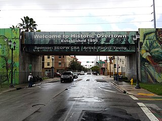
Overtown is a neighborhood of Miami, Florida, United States, just northwest of Downtown Miami. Originally called Colored Town in the Jim Crow era of the late 19th through the mid-20th century, the area was once the preeminent and is the historic center for commerce in the black community in Miami and South Florida.

<span class="mw-page-title-main">Brickell</span> Neighborhood of Miami in Miami-Dade County, Florida, United States

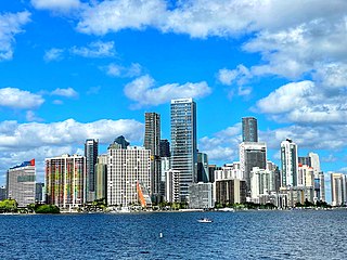
Brickell is a neighborhood in Miami, Florida, historically referenced at times as Southside, located directly east of Interstate 95, south of the Miami River and north of Coconut Grove. Brickell is known as the financial district of Miami, as well as South Florida.

<span class="mw-page-title-main">Greater Downtown Miami</span> Neighborhood in Miami-Dade County, Florida, United States

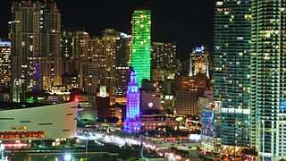
Downtown Miami is the urban city center of Miami, Florida, United States. The city's greater downtown region consists of the Central Business District, Brickell, the Historic District, Government Center, the Arts & Entertainment District, and Park West. It is divided by the Miami River and is bordered by Midtown Miami's Edgewater, and Wynwood sections to its north, Biscayne Bay to its east, the Health District and Overtown to its west, and Coconut Grove to its south.

<span class="mw-page-title-main">Miami Design District</span> Neighborhood of Miami in Miami-Dade County, Florida, United States

The Miami Design District is a neighborhood in Miami, Florida, United States, and a shopping, dining and cultural destination—home to over 130 art galleries, showrooms, creative services, architecture firms, luxury fashion stores, antiques dealers, eateries and bars.

<span class="mw-page-title-main">Wynwood</span> Neighborhood of Miami in Miami-Dade County, Florida, United States

Wynwood is a neighborhood in Miami, Florida. Wynwood is known for being an entertainment district, with artwork, restaurants, breweries, clothing stores, and dance venues, among other retail options. Formerly an industrial district, the area is now known for the murals that cover the walls of many of the buildings and many of the sidewalks. It is north of Downtown Miami and Overtown, and adjacent to Edgewater. Wynwood has two major sub-districts, the Wynwood Art District in northern Wynwood, and the Wynwood Fashion District along West 5th Avenue. Wynwood roughly is divided by North 20th Street to the south, I-195 to the north, I-95 to the west and the Florida East Coast Railway to the east.

<span class="mw-page-title-main">Upper Eastside</span> Neighborhood of Miami in Miami-Dade County, Florida, United States

The Upper Eastside is a neighborhood in Miami, Florida. It is north of Edgewater, east of Little Haiti, south of the village of Miami Shores, and sits on Biscayne Bay. In geographical order from south to north and east to west, it contains the subdivisions of Magnolia Park, Bay Point, Morningside, Bayside, Belle Meade, Shorecrest, and Palm Grove. The MiMo District along Biscayne Boulevard in the area is host to many art galleries, shops and restaurants.

<span class="mw-page-title-main">Edgewater (Miami)</span> Neighborhood of Miami in Miami-Dade County, Florida, United States

Edgewater is a neighborhood in Miami, Florida, located north of Downtown and the Arts & Entertainment District, and south of Midtown and the Upper Eastside. It is roughly bound by North 17th Street to the south, North 37th Street to the north, the Florida East Coast Railway and East First Avenue to the west and Biscayne Bay to the east.

<span class="mw-page-title-main">Coral Way</span> Neighborhood within Miami, Florida, US

Coral Way is a neighborhood within Miami, Florida that is defined by Coral Way, a road established by Coral Gables founder George E. Merrick during the 1920s. It is located in Miami-Dade County, Florida.

<span class="mw-page-title-main">Park West (Miami)</span> Neighborhood of Miami in Miami-Dade County, Florida, United States

Park West is a neighborhood of Greater Downtown, Miami, Florida. It is roughly bound by Biscayne Boulevard to the east, West (NW) First Avenue to the west, North (NE/NW) 7th Street to the south and Interstate 395 to the north. As of 2010, about 4,655 residents live in Park West. The neighborhood is named 'Park West' due to its location just west of Museum Park.

<span class="mw-page-title-main">Riverside (Miami)</span> Neighborhood of Miami in Miami-Dade County, Florida, United States

Riverside is a neighborhood in Miami, Florida, United States.

<span class="mw-page-title-main">Central Business District (Miami)</span> Central business district in the United States

The Central Business District (CBD) of Miami is the historic central business district and city center of what has become Greater Downtown Miami in Miami, Florida. Over 92,000 people work in Miami's Central Business District.

References

  1. "Buena Vista neighborhood in Miami, Florida (FL), 33127, 33137 subdivision profile - real estate, apartments, condos, homes, community, population, jobs, income, streets".
  2. "City of Miami - Neighborhood Enhancement Teams". Archived from the original on 2011-07-20. Retrieved 2011-06-05.
  3. "Buena Vista East Historic District". Archived from the original on 2011-04-02. Retrieved 2011-05-03.
  4. "Archived copy" (PDF). Archived from the original (PDF) on 2011-09-27. Retrieved 2011-07-26.{{cite web}}: CS1 maint: archived copy as title (link)
  5. Buena Vista, FL Community Profile
  6. 1 2 3 "Demographics of Buena Vista Miami, FL". city-data . Retrieved 2009-08-23.
  7. "Buena Vista East (Buena Vista East Historic District) neighborhood in Miami, Florida (FL), 33127, 33137 subdivision profile - real estate, apartments, condos, homes, community, population, jobs, income, streets".

25°48′47″N80°11′31″W / 25.813°N 80.192°W / 25.813; -80.192