Upper Eastside

Last updated
Upper Eastside
MiMo restaurant 20110218.jpg
A MiMo restaurant on Biscayne Boulevard in the Upper Eastside. The Upper Eastside is famous for its post war MiMo architecture, and is home to the MiMo Biscayne Boulevard Historic District.
Nickname(s): 
The Northeast, The Boulevard
Miami neighborhoodsmap.png
The Upper Eastside neighborhood within the City of Miami
Coordinates: 25°49′44″N80°11′06″W / 25.829°N 80.185°W / 25.829; -80.185
Country United States
State Florida
County Miami-Dade County
City Miami
Settled1909
Annexed into the City of Miami1924
Subdistricts of the Upper East Side
Neighborhoods list
  • Bay Point Estates
  • Bayside Historic District
  • Belle Meade
  • El Portal
  • Magnolia Park
  • MiMo Biscayne Boulevard Historic District
  • Morningside
  • Palm Grove
  • Shorecrest
Government
  City of Miami CommissionerMarc Sarnoff
  Miami-Dade CommissionerAudrey Edmonson
   House of Representatives Cynthia Stafford (D)
   State Senate Gwen Margolis (D)
   U.S. House Bill Nelson (D)
Population
 (2010)
  Total12,525
  Density6,509/sq mi (2,513/km2)
Time zone UTC-05 (EST)
ZIP Code
33137, 33138
Area code(s) 305, 786
Website Upper East Side neighborhood

The Upper Eastside (alternatively called East Side and commonly referred to as Northeast Miami [1] ) is a neighborhood in Miami, Florida. It is north of Edgewater, east of Little Haiti, south of the village of Miami Shores, and sits on Biscayne Bay. In geographical order from south to north and east to west, it contains the subdivisions of Magnolia Park, Bay Point, Morningside, Bayside, Belle Meade, Shorecrest, and Palm Grove. The MiMo District along Biscayne Boulevard in the area is host to many art galleries, shops and restaurants.

Contents

The Upper East Side is primarily a residential neighborhood, composed largely of historic single-family homes from the 1920s, 1930s, and 1940s, with Biscayne Boulevard running along the center of the neighborhood with mid-rise and high-rise office towers, hotels, and apartments. The MiMo Historic District runs along Biscayne Boulevard, and includes a large number of MiMo hotels from the 1950s and 1960s, that have been preserved, and have recently begun to be renovated, and turned into stores, restaurants and boutique hotels.

Geography

Magnolia Park lies east of Biscayne Boulevard between NE 37th Street (next to the Julia Tuttle Causeway) and NE 39th Street. Bay Point is east of the Boulevard, north of NE 39th Street and south of NE 50th Terrace. Morningside lies east of the Boulevard from NE 50th Terrace to NE 60th Street. Bayside is east of the Boulevard from NE 61st Street to NE 72nd Street. Belle Meade is east of the Boulevard from NE 72nd Terrace to NE 77th Terrace. Shorecrest is east of the Boulevard from NE 78th Street to NE 87th Street. Palm Grove is west of Biscayne Boulevard between NE 54th Street and NE 77th Street Road (i.e.: south of the Little River).

The area between NE 37th Street and NE 54th Street from Biscayne Boulevard westward one block to Federal Highway is not officially part of any of these neighborhoods but is nevertheless part of the UES. Similarly, the area from the Little River north to the city limits and between Biscayne Boulevard on the east and the Little River and the Village of El Portal on the west is not part of any of the aforementioned neighborhoods but is part of the UES.

Neighborhoods

Shorecrest

Shorecrest is the northernmost sub-neighborhood of the Upper East Side bounded by the Little River on the south (approximately NE 79th Street), Biscayne Boulevard on the west, Miami's northern city limits and the Village of Miami Shores to the north, and Biscayne Bay to the east. As of 2000, the population of Shorecrest was 3,989 people. Shorecrest is an ethnically diverse neighborhood . The racial makeup of the neighborhood was 35.80% Hispanic or Latino of any race, 31.94% White (non-Hispanic), and 29.13% Black or African American.

Shorecrest contains many historic single-family homes dating to the 1930s and 1940s, as well as some multi-family apartments and condominiums along its southern and western boundaries. The main commercial corridors in the neighborhood are 79th Street and Biscayne Boulevard. The area has experienced increased development and revitalization in recent years with the addition of new restaurants and stores. The sub-neighborhood of Daivs Harbor, located east of NE 10th Avenue contains various waterfront homes with access to Biscayne Bay.

Palm Grove

Palm Grove is a historic neighborhood which lies within the Upper East Side, bounded by Biscayne Boulevard to the east, NE 54th Street to the south, the Little River on the north, and the Florida East Coast Railway tracks on the west. The neighborhood contains many historic homes from the 1920s and 1930s, many of which have recently been renovated and restored. Palm Grove is a diverse community consisting of artists, young professionals, and Haitian immigrants. As of 2000, the population of Palm Grove was 3,349. The racial makeup of the neighborhood was 22.77% Hispanic or Latino of any race, 56.79% Black or African American, and 10.69% White (non-Hispanic).

The Palm Grove Neighborhood contains a significant collection of residential architecture from the early to mid-20th century. The most dominant styles in the district are Spanish Eclectic and Mission, reflecting the strong influence of the Spanish Colonial and Revival styles in Florida during this period. The district also contains notable examples of the Art Deco, Art Moderne, Craftsman, and Colonial Revival styles of the early 20th century. By mid-century, other building styles such as Minimal Traditional and Ranch were constructed. Several dwellings were also built in a local style known as "Miami Modern" or "Mimo."

Miami Ironside

Ironside is an urban art and design district located in Miami's Upper Eastside, off of the MiMo Historic Biscayne Boulevard and along the northwest boundary of Palm Grove. The stretch of industrial warehouses was acquired in 2003 by local developer Ofer Mizrahi, and envisioned as an interconnected network of mixed-purpose architectural complexes. It is home to over 65 designer showrooms, art galleries, architecture firms, creative services, eateries, residences, multi-purpose spaces, and a public piazza with permanent Berlin Wall sculptures painted by street artist Thierry Noir. Twice a year, Ironside hosts a Campus Collective, a community event.

Belle Meade

Belle Meade is a sub-neighborhood which lies within the larger enclave of the Upper East Side. It is a private, gated community and the southern part contains a smaller subdivision known as the Bayside Historic District. The northern part contains Belle Meade Island. It is bounded by the Little River to the north, northeast 72nd Terrace to the south, Biscayne Boulevard to the west, and Biscayne Bay to the east. [2]

Demographics of Belle Meade

As of 2000, the population of Belle Meade had 2,149 people. The zip code for Belle Meade is 33138. The area covers 0.433 square miles (1.12 km2). As of 2000, there were 1,248 males and 900 females. The median age for males were 35.2 years old, while the median age for females were 35.5 years old. The average household size had 2.0 people, while the average family size had 2.8 members. The percentage of married-couple families (among all households) was 26.8%, while the percentage of married-couple families with children (among all households) was 9.0%, and the percentage of single-mother households (among all households) was 3.6%. The percentage of never-married males 15 years old and over was 31.6%, while the percentage of never-married females 15 years old and over was 13.1%. [2]

As of 2000, the percentage of people that speak English not well or not at all made up 6.5% of the population. The percentage of residents born in Florida was 20.4%, the percentage of people born in another U.S. state was 46.8%, and the percentage of native residents but born outside the U.S. was 4.1%, while the percentage of foreign born residents was 28.7%. [2]

As of 2000, the racial makeup of Belle Meade (including the Bayside Historic District) was 42.68% Hispanic or Latino of any race, 1.60% Black or African American, and 52.66% White (non-Hispanic).

Morningside

Morningside Park Morningside Park Miami 20110216.jpg
Morningside Park

Morningside is a residential historic sub-neighborhood within the Upper Eastside in an older part of the City of Miami, Florida, United States. It lies mostly to the east of Biscayne Boulevard from NE 50th Terrace to NE 62nd Street. [3] Morningside is just north of and adjacent to Bay Point Estates, another more affluent but less historic residential enclave in urban Miami.

When Pope John Paul II visited the United States, he stayed at what was then the home of Archbishop Edward McCarthy on NE 53rd Street.

History of Morningside

Started in the 1920s as "Bay Shore," it prospered in the mid-20th century and fell on hard times along with most of Miami's other inner city neighborhoods in the 60's and 70's. More recently Morningside was the first historic area in central Miami to experience gentrification with an influx of more-affluent residents. It has now been fully restored. The Morningside Historic District runs from NE 55th Street to NE 60th Street; it was the first historic district to be designated as such in the City of Miami. The district was added to the National Register of Historic Places in 1992 as the Bay Shore Historic District. [4]

The Morningside Historic District is significant to the history of architecture, landscape architecture, and community development in Miami. Developed primarily between 1922 and 1941, Morningside contains a wealth of Mediterranean, Art Deco, and vernacular style houses that reflect the diversity and direction of architectural design during the 1920s and 1930s. Morningside is one of Miami's best planned subdivisions, featuring wide, tree-lined boulevards that contribute to the character of the area. This neighborhood was envisioned as an exclusive, residential community, and its amenities and location on Biscayne Bay attracted many influential and prominent local residents. One of Miami's most intact historic neighborhoods, Morningside is the city's best remaining example of a boom-era suburb.

The Morningside Historic District stands today as one of Miami's most intact historic neighborhoods. Despite the number of post-1941 buildings in the area, Morningside retains a high degree of historic and architectural integrity. This is due, in part, to the fact that most later buildings are not intrusive, but respect the earlier structures in scale, setback, materials, and workmanship. The majority of neighborhood residents recognize the special character of the area and desire its continued preservation.

As Miami's population expanded during the late 1920s and early 1920s, new subdivisions reached northward along Biscayne Bay. In 1922, a large, undeveloped bayfront tract near the northern city limits was platted. Called Bay Shore, this area was subdivided by the Bay Shore Investment Company and was the first of three phases that would be developed by the company between 1922 and 1924. [5]

Architecture of Morningside

Houses constructed in the Morningside Historic District reflect the eclecticism popular in the early twentieth century. The earlier buildings in the district are predominantly Mediterranean Revival in style, while structures built in the 1930s and early 1940s are frequently Art Deco. Outstanding examples of both styles are found here. Morningside also features a large number of masonry vernacular buildings that frequently utilize elements of several styles. An unusual Tudor Revival style house and one of the city's best examples of Mission style architecture add to the area's architectural diversity.

Demographics of Morningside

As of 2000, the population of Morningside was 1,074 people. The racial makeup of Morningside was 14.90% Hispanic or Latino of any race, 28.49% Black or African American, and 55.21% White (non-Hispanic).

Bay Point

Bay Point is a sub-neighborhood in the Upper East Side neighborhood. It is a gated community stretching from NE 41st Street to NE 50th Street alongside Biscayne Boulevard. The neighborhood streets are privately owned by the households and access to the roads and waterways are restricted to the residents (and their guests), of which there are approximately 250. To maintain the streets and the neighborhood's 24-hour security, all residents must pay neighborhood dues that can total approximately $2,200 per year. As of 2000, the population of Bay Point was 1,378 people. The racial makeup of Baypoint was 49.20% Hispanic or Latino of any race, 5.2% Black or African American, and 36.7% White (non-Hispanic).[ citation needed ]

Bayside Historic District

The Bayside Historic District is a sub-neighborhood of the Upper East Side. The area is generally bounded by NE 72nd Street and N.E. 72nd Terrace on the north; Biscayne Bay on the east; NE 67th Street on the south; and Biscayne Boulevard to the west.

History of Bayside

The Bayside Historic District reflects the formative years of the early 1900s through the mid-1940s. Once a part of the pioneer settlement of Lemon City, Bayside contains the oldest intact community in Northeast Miami, as well as one of this area's last remaining bayfront estates. Bayside has four distinct subdivisions which were platted between 1909 and 1925, although the area itself was first settled in the late nineteenth century. These subdivisions include Elmira (N.E. 68th Street and N.E. 67th Street), which was platted in 1909; Acadia (N.E. 70th Street), which was platted in 1915; Baywood (N.E. 69th Street and the south side of N.E. 71st Street), which was platted in 1921 and added to in 1924; and Washington Place (N.E. 72nd Street and the north side of N.E. 71st Street), which was platted in 1925.

In 1909, William B. and Fred C. Miller (not related) subdivided a seven-acre (2.8 ha) bayfront lot on today's N.E. 68th Street. The Millers had come to Florida in the late 1880s from Elmira, New York and had developed Elmira Farms near Arch Creek. Their new subdivision was named Elmira, and oolitic limestone gates announced the entrance to the new community.

While much of what was Lemon City has been engulfed by later developments, Elmira has remained virtually intact. Although many of its houses have deteriorated, and newer buildings have been added, the street retains much of its early character. Elmira is characterized by its excellent collection of Frame Vernacular buildings, many of which were inspired by Northern architectural styles. The Elmira Club at 742 N.E. 68th Street, for example, has Dutch Colonial Revival influences, while other houses display classical details. The majority of houses were constructed in the 1910s.

The Acadia subdivision was platted in 1915 by the Realty Securities Corporation and George E. Merrick. Although the subdivision evokes the memory of Longfellow with such names as Acadian Way, Evangeline Circle, Tropical Trail, and Druid Walk, the houses developed here are distinctly Mediterranean Revival in influence. This is due perhaps to the fact that only two houses were constructed prior to 1925. Development took off during the Boom years of the mid-1920s, however, when Wykoff and Estes Builders constructed an outstanding cluster of large, two-story Mediterranean Revival style houses near the eastern end of NE 70th Street.

The last subdivision to be subdivided was Washington Place, which was also developed between 1925 and the mid-1940s. Samuel J. Prescott, who platted the subdivision in 1925, had constructed his own winter home at 7101 N.E. 10th Avenue some years before. The house remains today as one of the last intact bayfront estates in Northeast Miami. The estate once featured a recreational golf course for residents and guests. Prescott was founder of the firm of Samuel J. Prescott Co., Inc., building contractors, which developed several significant buildings in downtown Washington, D.C. Prescott was chairman of the board of the Second National Bank of Washington, D.C., president of the Master Builders Association, the Builders and Manufacturers Exchange, and the Prescott Farms Company of New Hampshire.

The Bayside Historic District remains today as an intact, cohesive neighborhood. Despite the number of post-1941 buildings, Bayside retains a high level of historic and architectural integrity. [6]

Demographics

The Upper East Side has a population of 15,056 of different ethnicities and races that includes high, middle and low income residents. Biscayne Boulevard is the central spine of this neighborhood. [1] The neighborhood like the rest of Miami is quickly becoming composed mostly of artistic and bright colored homes and condos. The area has some of the highest crime rates in Miami for an area that has a substantial amount of middle- and high-income residents.

As of 2010, [7] The Upper Eastside had a population of 15,056 residents, with 6,263 households, and 3,167 families residing in the neighborhood. The median household income was $35,196.16. The racial makeup of the neighborhood was 37.26% Hispanic or Latino of any race, 29.65% Black or African American, 28.68% White (non-Hispanic), and 4.41% Other races (non-Hispanic).

MiMo Historic District

MiMo District sign MiMo sign 20110218.jpg
MiMo District sign

Today, the area along Biscayne Boulevard is the designated MiMo Architecture Biscayne Boulevard Historic District or also known as "MiMo on BiBo", for "Miami Modern on Biscayne Boulevard". MiMo Historic District runs roughly from 50th Street to 77th Street along Biscayne Boulevard, although MiMo can be found heavily in the Miami Design District and Midtown. Many annual festivals are held to promote MiMo architecture, such as "Cinco de MiMo" a play on "Cinco de Mayo" in early May.

Biscayne Boulevard throughout the Upper East Side fell to urban decay after the 1980s, and experienced increased crime, prostitution and drug dealings. In the 2000s, preservation efforts began to bring development interest into the neighborhood, and Biscayne Boulevard began to improve. Today, the boulevard is in a fast upwards transition along with many other nearby neighborhoods such as the Design District, Wynwood and Edgewater, with strong preservation efforts to preserve the MiMo architecture.

Zoning and public projects

Under pressure from residents to keep undesirably large buildings out, The Miami City Commission considered new building codes and a 180-day moratorium on February 26 of 2007. With many homes built in the late 1920s, the Upper Eastside encompasses some of Miami's oldest neighborhoods and residents desire to keep it that way. The proposed codes were looser on distance to low-density areas but stricter on building height. [8]

A beautification and landscape project was recently completed on Biscayne Boulevard and Legion Park and Eaton Park recently received improvements such as new playground equipment. Construction on new Little River Canal and efforts to fight crime are currently being worked on. [1]

Education

Miami-Dade County Public Schools operates area public schools:

The Archdiocese of Miami operates:

Other private schools in the Upper East Side include:

Libraries

Miami-Dade Public Library operates area public libraries:

Parks

See also

Related Research Articles

<span class="mw-page-title-main">Miami</span> City in Florida, US

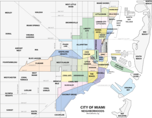
Miami, officially the City of Miami, is a coastal metropolis and the seat of Miami-Dade County in South Florida, United States of America. With a population of 442,241 as of the 2020 census, it is the second-most populous city in the state of Florida after Jacksonville. It is the core of the much larger Miami metropolitan area, which, with a population of 6.14 million, is the third-largest metro in the Southeast and ninth-largest in the United States. The city has the third-largest skyline in the U.S. with over 300 high-rises, 58 of which exceed 491 ft (150 m).

<span class="mw-page-title-main">Homestead, Florida</span> City in Florida

Homestead is a city within Miami-Dade County in the U.S. state of Florida, between Biscayne National Park to the east and Everglades National Park to the west. The population was 80,737 as of the 2020 census. Homestead is primarily a Miami suburb and a major agricultural area. It is a principal city of the Miami metropolitan area, which was home to an estimated 6,012,331 people at the 2015 census. It is located approximately 26 miles (42 km) southwest of Miami, and 25 miles (40 km) northwest of Key Largo.

<span class="mw-page-title-main">Coconut Grove</span> Neighborhood of Miami, Florida, United States

Coconut Grove, also known colloquially as The Grove, is an affluent and the oldest continuously inhabited neighborhood of Miami in Miami-Dade County, Florida. The neighborhood is roughly bound by North Prospect Drive to the south, LeJeune Road to the west, South Dixie Highway and Rickenbacker Causeway to the north, and Biscayne Bay to the east. It is south of the neighborhoods of Brickell and The Roads and east of Coral Gables. The neighborhood's name has been sometimes spelled "Cocoanut Grove" but the definitive spelling "Coconut Grove" was established when the city was incorporated in 1919.

Bayside may refer:

<span class="mw-page-title-main">South Beach</span> Neighborhood of Miami Beach in Miami-Dade County, Florida, United States

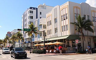
South Beach, also nicknamed colloquially as SoBe, is a neighborhood in Miami Beach, Florida. It is located east of Miami between Biscayne Bay and the Atlantic Ocean. The area encompasses Miami Beach south of Dade Boulevard.

<span class="mw-page-title-main">Little Havana</span> Neighborhood of Miami in Miami-Dade, Florida, United States

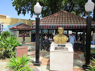
Little Havana is a neighborhood of Miami, Florida, United States. Home to many Cuban exiles, as well as many immigrants from Central and South America, Little Havana is named after Havana, the capital and largest city in Cuba.

<span class="mw-page-title-main">Miami Modern architecture</span>

Miami Modernist architecture, or MiMo, is a regional style of architecture that developed in South Florida during the post-war period. The style was internationally recognized as a regionalist response to the International Style. It can be seen in most of the larger Miami and Miami Beach resorts built after the Great Depression. Because MiMo styling was not just a response to international architectural movements but also to client demands, themes of glamour, fun, and material excess were added to otherwise stark, minimalist, and efficient styles of the era. The style can be most observed today in Middle and Upper Miami Beach along Collins Avenue, as well as along the Biscayne Boulevard corridor starting from around Midtown, through the Design District and into the Upper Eastside.

<span class="mw-page-title-main">Little Haiti</span> Neighborhood of Miami in Miami-Dade County, Florida, United States

Little Haiti, is a neighborhood of Miami, Florida, United States. It is known historically as Lemon City, Little River and Edison. It is home to Haitian immigrant residents, as well as residents from the rest of the Caribbean.

<span class="mw-page-title-main">Bay Shore Historic District</span> Historic district in Florida, United States

The Bay Shore Historic District is a U.S. historic district located in Miami, Florida. The district is bounded by Northeast 55th Street, Biscayne Boulevard, Northeast 60th Street and Biscayne Bay, in the Morningside section of the Upper Eastside neighborhood. It contains 223 historic buildings.

<span class="mw-page-title-main">Greater Downtown Miami</span> Neighborhood of Miami in Miami-Dade County, Florida, United States

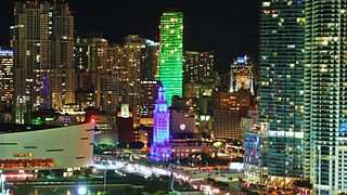
Downtown Miami is the urban city center of Miami, Florida. The city's greater downtown region consists of the Central Business District, Brickell, the Historic District, Government Center, the Arts & Entertainment District, and Park West. It is divided by the Miami River and is bordered by Midtown Miami's Edgewater and Wynwood sections to its north, Biscayne Bay to its east, the Health District and Overtown to its west, and Coconut Grove to its south.

<span class="mw-page-title-main">Edgewater (Miami)</span> Neighborhood of Miami in Miami-Dade County, Florida, United States

Edgewater is a neighborhood in Miami, Florida, located north of Downtown and the Arts & Entertainment District, and south of Midtown and the Upper Eastside. It is roughly bound by North 17th Street to the south, North 37th Street to the north, the Florida East Coast Railway and East First Avenue to the west and Biscayne Bay to the east.

<span class="mw-page-title-main">Broadway–Flushing, Queens</span> Neighborhood of Queens in New York City

Broadway–Flushing is a historic district and residential subsection of Flushing, Queens, New York City. The neighborhood comprises approximately 2,300 homes. It is located between 155th and 170th Streets to the west and east respectively, and is bounded on the north by Bayside and 29th Avenues, and on the south by Northern Boulevard and Crocheron Avenue. Broadway–Flushing is listed on the National Register of Historic Places.

<span class="mw-page-title-main">Buena Vista (Miami)</span> Neighborhood of Miami in Miami-Dade County, Florida, United States

Buena Vista is a neighborhood in Miami, Florida, United States. It is located south of Little Haiti, north of the Miami Design District.

Isle of Normandy or Normandy Island or Normandy Isles or Normandy Isle is a neighborhood of North Beach in the city of Miami Beach, Florida. It is located along the eastern shore of Biscayne Bay.

<span class="mw-page-title-main">Arts & Entertainment District</span> Neighborhood of Miami in Miami-Dade County, Florida, United States

The Arts & Entertainment District, or previously known as Omni, is a neighborhood of Downtown Miami, Florida. It is bound roughly by North 19th Street to the north, North 10th Street to the south, North West 2nd Avenue to the west, and Biscayne Boulevard to the east.

Portland, Maine, is home to many neighborhoods.

<span class="mw-page-title-main">Park West (Miami)</span> Neighborhood of Miami in Miami-Dade County, Florida, United States

Park West is a neighborhood of Greater Downtown, Miami, Florida. It is roughly bound by Biscayne Boulevard to the east, West (NW) First Avenue to the west, North (NE/NW) 7th Street to the south and Interstate 395 to the north. As of 2010, about 4,655 residents live in Park West. The neighborhood is named 'Park West' due to its location just west of Museum Park.

<span class="mw-page-title-main">Eastside, Atlanta</span> City district of Atlanta, Georgia

Eastside refers to the city district comprising the easternmost portion of Atlanta, Georgia, United States. The Eastside generally encompasses the area bounded on the west by Midtown Atlanta and Downtown Atlanta and on the east by the city limits. The central corridor of the district is the BeltLine Eastside Trail, which connects northern Eastside neighborhoods with those to the south. The Eastside is known for its nightlife establishments, craftsman architecture, local eateries, and quirky public art.

<span class="mw-page-title-main">Miami Ironside</span> Neighborhood in Miami, Florida

Miami Ironside is an urban art and design district located in Miami's Upper Eastside, off of the MiMo Historic Biscayne Boulevard.

<span class="mw-page-title-main">Central Business District (Miami)</span> Central business district in the United States

The Central Business District (CBD) of Miami is the historic central business district and city center of what has become Greater Downtown Miami in Miami, Florida. Over 92,000 people work in Miami's Central Business District.

References

  1. 1 2 3 Neighborhood Enhancement Team Profile
  2. 1 2 3 "Demographics of Belle Meade, Miami, FL". city-data . Retrieved June 29, 2018.
  3. Morningside (Bayshore) neighborhood, detailed profile
  4. Tulie W. Taylor; Sarah Eaton (August 21, 1992). "National Register of Historic Places Registration Form: Bay Shore Historic District". National Park Service . Retrieved June 29, 2018. Accompanying 26 photos.
  5. "Morningside Historic District" (PDF). Retrieved June 29, 2018.
  6. "Bayside Historic District" (PDF). Retrieved June 29, 2018.
  7. "Demographics of Upper Eastside Miami, FL". miamigov.com. Archived from the original on May 17, 2008. Retrieved June 11, 2008.
  8. Paola Iuspa-Abbott (February 23, 2004). "Upper Eastside residents: Change architectural limits". South Florida Business Journal. Retrieved June 29, 2018.