Related Research Articles

Crow Agency is a census-designated place (CDP) in Big Horn County, Montana, United States and is near the actual location for the Little Bighorn National Monument and re-enactment produced by the Real Bird family known as Battle of the Little Bighorn Reenactment. The population was 1,616 at the 2010 census. It is the governmental headquarters of the Crow Native Americans. It is also the location of the "agency offices" where the federal Superintendent of the Crow Indian Reservation and his staff interacts with the Crow Tribe, pursuant to federal treaties and statutes.

Mineral Wells is a city in Palo Pinto and Parker Counties in the U.S. state of Texas. The population was 14,820 at the 2020 census. The city is named for mineral wells in the area, which were highly popular in the early 1900s.
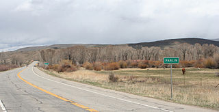
Parlin is an unincorporated community and a U.S. Post Office in Gunnison County, Colorado, United States. The Parlin Post Office has the ZIP Code 81239.
Powderhorn is an unincorporated community and a U.S. Post Office in Gunnison County, Colorado, United States. The Powderhorn Post Office has the ZIP Code 81243.

Syria is an unincorporated village in Madison County, Virginia, United States. It lies along the Old Blue Ridge Turnpike, adjoining the southeast border of the Shenandoah National Park. Its ZIP Code is 22743.

Wrigley is an unincorporated community in Morgan County, Kentucky, United States. It lies along Route 7, north of the city of West Liberty, the county seat of Morgan County. Its elevation is 817 feet (249 m), and it is located at 38°1′6″N83°16′17″W. It has a post office with the ZIP code 41477.

Hobson is a city in Judith Basin County, Montana, United States. The population was 179 at the 2020 census.

Highbridge is an unincorporated community located in the town of Ashland, Ashland County, Wisconsin, United States. Highbridge is located on Wisconsin Highway 13 6 miles (9.7 km) northwest of Mellen. Highbridge has a post office with ZIP code 54846. Bus service to the community is provided by Bay Area Rural Transit.
Condon is an unincorporated community and census-designated place in Missoula County, Montana, United States. Located along the Swan River and Montana Highway 83, Condon is situated between the Swan Range to the east and the Mission Mountains to the west, providing ready access to the Bob Marshall Wilderness and Mission Mountains Wilderness, respectively. Its population was 343 as of the 2010 census.
Jackson is an unincorporated community in Beaverhead County, Montana, United States. Jackson has a post office with a ZIP code 59736. As of the 2020 census, Jackson had a population of 36.
Polaris is an unincorporated community in Beaverhead County, Montana, United States. Polaris has a post office with a ZIP code 59746. Polaris lies in the Grasshopper Valley, along the Pioneer Mountain Scenic Byway, southeast of Wisdom. This community takes its name from the Polaris Mine, which operated as a silver mine from 1885 until 1922.

Cedar Creek is an unincorporated community in Bastrop County, Texas, United States, located 11 miles (18 km) west of Bastrop at the intersection of State Highway 21 and Farm to Market Road 535. Cedar Creek has a post office with a ZIP code 78612. The community takes its name from Cedar Creek, a tributary of the Colorado River.
Lorentz is an unincorporated community in Upshur County, West Virginia, United States. Lorentz is located on U.S. routes 33 and 119, 4 miles (6.4 km) west-northwest of Buckhannon. Lorentz has a post office with ZIP code 26229.

Skyforest is an unincorporated community in San Bernardino County, California, United States.
Hilger is an unincorporated community and census-designated place in Fergus County, Montana, United States. The community is located along U.S. Highway 191 in central Fergus County. Hilger has a post office with the ZIP code 59451. It is 15 miles north of Lewistown.

Moccasin is an unincorporated community in Judith Basin County, Montana, United States. The community was named for the nearby Moccasin mountain range. Moccasin has a post office with the ZIP code 59462.
Acton is an Census Designated Place in northwestern Yellowstone County, Montana, United States. It has a postal ZIP code (59002) and lies along Montana Highway 3 northwest of the city of Billings, the county seat of Yellowstone County.
Zurich is an unincorporated community in Blaine County, Montana, United States, located at 48°35′4″N109°1′50″W. Located along the Hi-Line of Montana, between Harlem and Chinook, along U.S. Route 2. It has a post office with the ZIP code of 59547, and a public school serving grades PK through 8. There is also a bar; the store and bank are closed and abandoned, as are two grain elevators and other business buildings. Various online sources give the population as 22-23 residents.
Zortman is a census-designated place and unincorporated community in Phillips County, Montana, United States. Its population was 69 as of the 2010 census. Zortman has a post office with ZIP code 59546.
Brady is a census-designated place and unincorporated community in Pondera County, Montana, United States. Its population was 140 as of the 2010 census. Brady has a post office with ZIP code 59416. The community is located along Interstate 15.
References
- ↑ USPS – Cities by ZIP Code Archived June 15, 2011, at the Wayback Machine
- 1 2 Carkeek Cheney, Roberta (1983). Names on the Face of Montana. Missoula, Montana: Mountain Press Publishing Company. ISBN 0-87842-150-5.
- ↑ "Montana Place Names Companion". Montana Historical Society. Retrieved July 29, 2017.
- ↑ Climate Summary for Buffalo, Montana
- ↑ "Weatherbase.com". Weatherbase. 2013. Retrieved on September 5, 2013.
