Milford Colony is a Hutterite community and census-designated place (CDP) in Lewis and Clark County, Montana, United States. It is in the northeast part of the county, along U.S. Route 287, 15 miles (24 km) southeast of Augusta and 24 miles (39 km) north of Interstate 15 near Wolf Creek.
North Harlem Colony is a Hutterite community and census-designated place (CDP) in Blaine County, Montana, United States. It is in the northeast part of the county, half a mile east of Secondary Highway 241 and 4 miles (6 km) north of Harlem and U.S. Route 2. It sits atop a 100-foot-high (30 m) bluff on the east side of Forgey Creek, a southeast-flowing tributary of the Milk River.
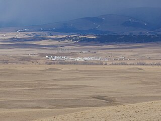
Cascade Colony is a Hutterite community and census-designated place (CDP) in Cascade County, Montana, United States. It is in the northwest part of the county along Birdtail Creek Road, 5 miles (8 km) south of Fort Shaw and 30 miles (48 km) west-southwest of Great Falls. 4,639-foot (1,414 m) Shaw Butte rises above the community to the northwest.
Ayers Ranch Colony is a Hutterite community and census-designated place (CDP) in Fergus County, Montana, United States. It is in the southeastern part of the county, on the north side of U.S. Route 87/Montana Highway 200, 8 miles (13 km) west of Grass Range and 24 miles (39 km) east of Lewistown. The North Fork of McDonald Creek runs through the community, part of the Musselshell River watershed leading to the Missouri River.
Deerfield Colony is a Hutterite community and census-designated place (CDP) in Fergus County, Montana, United States. It is in the western part of the county, on the south side of Montana Highway 81, 25 miles (40 km) northwest of Lewistown and 14 miles (23 km) southeast of Denton.
Fords Creek Colony is a Hutterite community and census-designated place (CDP) in Fergus County, Montana, United States. It is in the eastern part of the county, 12 miles (19 km) northwest of Grass Range and 29 miles (47 km) northeast of Lewistown.
King Ranch Colony is a Hutterite community and census-designated place (CDP) in Fergus County, Montana, United States. It is in the western part of the county, 3 miles (5 km) northwest of U.S. Routes 87/191 and 11 miles (18 km) west of Lewistown, the county seat.
Glendale Colony is a Hutterite community and census-designated place (CDP) in Glacier County, Montana, United States. It is in the northeastern part of the county, within the Blackfeet Indian Reservation, 21 miles (34 km) north-northwest of Cut Bank.
Horizon Colony is a Hutterite community and census-designated place (CDP) in Glacier County, Montana, United States. It is on the eastern side of the county, 11 miles (18 km) northeast of Cut Bank and 30 miles (48 km) northwest of Shelby.
Seville Colony is a Hutterite community and census-designated place (CDP) in Glacier County, Montana, United States. It is in the eastern part of the county, 17 miles (27 km) by road northwest of Cut Bank and 26 miles (42 km) northeast of Browning.
Surprise Creek Colony is a Hutterite community and census-designated place (CDP) in Judith Basin County, Montana, United States. It is in the north-central part of the county, in the valley of Surprise Creek, a north-flowing tributary of Arrow Creek, which continues northeast to the Missouri River.
Eagle Creek Colony is a Hutterite community and census-designated place (CDP) in Liberty County, Montana, United States. It is in the northwest part of the county, 20 miles (32 km) northwest of Chester, the county seat.
East Malta Colony is a Hutterite community and census-designated place (CDP) in Phillips County, Montana, United States. It is in the eastern part of the county, 14 miles (23 km) by road east of Malta, the county seat. It sits on high ground just west of Beaver Creek, a north-flowing tributary of the Milk River.
Birch Creek Colony is a Hutterite community and census-designated place (CDP) in Pondera County, Montana, United States. It is in the west-central part of the county, 5 miles (8 km) north of Dupuyer and 13 miles (21 km) southwest of Valier.
New Rockport Colony is a Hutterite community and census-designated place (CDP) in Teton County, Montana, United States. It is in the east-central part of the county, 11 miles (18 km) northeast of Choteau, the county seat, and 16 miles (26 km) west of Dutton. The colony sits on a bluff overlooking the Teton River to the southeast and Spring Coulee to the northeast.
Martinsdale Colony is a Hutterite community and census-designated place (CDP) in Wheatland County, Montana, United States. It is on the western edge of the county, bordered to the west by Meagher County and 4 miles (6 km) northeast of the unincorporated community of Martinsdale. The Musselshell River forms the southern edge of the CDP.
Mountain View Colony is a Hutterite community and census-designated place (CDP) in Yellowstone County, Montana, United States. It is in the western part of the county, 10 miles (16 km) to the southeast of Broadview and 26 miles (42 km) northwest of Billings.
Pearl Creek Colony is a Hutterite colony and census-designated place (CDP) in Beadle County, South Dakota, United States. It was first listed as a CDP prior to the 2020 census. The population of the CDP was 99 at the 2020 census.
Old Elm Spring Colony is a Hutterite colony and census-designated place (CDP) in Hutchinson County, South Dakota, United States. The population was 114 at the 2020 census. It was first listed as a CDP prior to the 2020 census.
Spring Valley Colony is a Hutterite colony and census-designated place (CDP) in Jerauld County, South Dakota, United States. It was first listed as a CDP prior to the 2020 census.


