Bunker Hill, Indiana

Last updated

Bunker Hill, Indiana
Miami County Indiana Incorporated and Unincorporated areas Bunker Hill Highlighted 1809136.svg
Location in Miami County, Indiana
Coordinates: 40°39′36″N86°06′05″W / 40.66000°N 86.10139°W / 40.66000; -86.10139
Country United States
State Indiana
County Miami
Township Pipe Creek
Founded1851
Founded byJames Myers, John Duckwall and Alexander Galbraith
Area
[1]
  Total0.39 sq mi (1.01 km2)
  Land0.39 sq mi (1.01 km2)
  Water0.00 sq mi (0.00 km2)
Elevation
[2]
817 ft (249 m)
Population
 (2020) [3]
  Total814
  Density2,092.54/sq mi (808.46/km2)
Time zone UTC-5 (Eastern (EST))
  Summer (DST) UTC-5 (EST)
ZIP code
46914
Area code 765
FIPS code 18-09136 [4]
GNIS feature ID2396616 [2]
Website https://www.townofbunkerhillin.com/

Bunker Hill is a town in Pipe Creek Township, Miami County, in the U.S. state of Indiana. [2] The population was 814 at the 2020 census, [3] down from 888 in 2010. [5]

Contents

History

Bunker Hill was platted in 1851 by James Myers, John Duckwall and Alexander Galbraith. [6]

A post office opened in 1859. The Pan Handle Railroad came to Bunker hill in 1868. [7]

Geography

Bunker Hill is located in southern Miami County. Indiana State Road 218 passes through the center of town, leading west 1 mile (1.6 km) to U.S. Route 31 and east 7 miles (11 km) to State Road 19 at Santa Fe. Grissom Air Reserve Base is one mile west of Bunker Hill, across U.S. 31. Peru, the Miami county seat, is 8 miles (13 km) north of Bunker Hill.

According to the U.S. Census Bureau, Bunker Hill has an area of 0.39 square miles (1.01 km2), all land. [1] Pipe Creek, a northwest-flowing tributary of the Wabash River, runs along the northern border of the town.

Demographics

Historical population
CensusPop.Note
1880 596
1890 538−9.7%
1900 5685.6%
1910 66817.6%
1920 550−17.7%
1930 528−4.0%
1940 5616.3%
1950 65917.5%
1960 1,04959.2%
1970 956−8.9%
1980 9842.9%
1990 1,0102.6%
2000 987−2.3%
2010 888−10.0%
2020 814−8.3%
U.S. Decennial Census [8]

2010 census

As of the census [9] of 2010, there were 888 people, 366 households, and 249 families living in the town. The population density was 2,114.3 inhabitants per square mile (816.3/km2). There were 445 housing units at an average density of 1,059.5 per square mile (409.1/km2). The racial makeup of the town was 93.7% White, 1.6% African American, 0.8% Native American, 0.8% Asian, 0.7% from other races, and 2.5% from two or more races. Hispanic or Latino of any race were 2.0% of the population.

There were 366 households, of which 37.2% had children under the age of 18 living with them, 46.4% were married couples living together, 15.3% had a female householder with no husband present, 6.3% had a male householder with no wife present, and 32.0% were non-families. 26.0% of all households were made up of individuals, and 10.1% had someone living alone who was 65 years of age or older. The average household size was 2.43 and the average family size was 2.87.

The median age in the town was 37.4 years. 25.7% of residents were under the age of 18; 10.8% were between the ages of 18 and 24; 23.9% were from 25 to 44; 25.3% were from 45 to 64; and 14.3% were 65 years of age or older. The gender makeup of the town was 48.3% male and 51.7% female.

2000 census

As of the census [4] of 2000, there were 987 people, 397 households, and 277 families living in the town. The population density was 2,262.6 inhabitants per square mile (873.6/km2). There were 423 housing units at an average density of 969.7 per square mile (374.4/km2). The racial makeup of the town was 94.93% White, 1.32% African American, 0.51% Native American, 0.61% Asian, 0.10% from other races, and 2.53% from two or more races. Hispanic or Latino of any race were 1.11% of the population.

There were 397 households, out of which 36.3% had children under the age of 18 living with them, 54.9% were married couples living together, 11.3% had a female householder with no husband present, and 30.0% were non-families. 27.0% of all households were made up of individuals, and 9.6% had someone living alone who was 65 years of age or older. The average household size was 2.49 and the average family size was 3.02.

In the town, the population was spread out, with 29.1% under the age of 18, 8.4% from 18 to 24, 28.2% from 25 to 44, 22.6% from 45 to 64, and 11.8% who were 65 years of age or older. The median age was 34 years. For every 100 females, there were 94.3 males. For every 100 females age 18 and over, there were 90.7 males.

The median income for a household in the town was $36,154, and the median income for a family was $44,861. Males had a median income of $34,722 versus $22,625 for females. The per capita income for the town was $17,000. About 3.3% of families and 7.1% of the population were below the poverty line, including 6.7% of those under age 18 and 8.5% of those age 65 or over.

Education

School Districts

Maconaquah High School competes in the Three Rivers Conference (TRC) for athletics.

Notable people

Related Research Articles

<span class="mw-page-title-main">Michigantown, Indiana</span> Town in Indiana, United States

Michigantown is a town in Michigan Township, Clinton County, Indiana, United States. The population was 467 at the 2010 census. The town was named for the Michigan Road, an early thoroughfare through the area.

<span class="mw-page-title-main">Rossville, Indiana</span> Town in Indiana, United States

Rossville is a town in Ross Township, Clinton County, Indiana, United States. The population was 1,653 at the 2010 census.

<span class="mw-page-title-main">West Harrison, Indiana</span> Town in Indiana, United States

West Harrison is a town in Harrison Township, Dearborn County, Indiana, United States. The population was 289 at the 2010 census.

<span class="mw-page-title-main">Ashley, Indiana</span> Town in Indiana, United States

Ashley is a town in Indiana located on the border of Smithfield Township, DeKalb County and Steuben Township, Steuben County. The population was 983 at the 2010 census.

<span class="mw-page-title-main">Akron, Indiana</span> Town in Indiana, United States

Akron is a town in Henry Township, Fulton County, Indiana, United States. The population was 1,167 at the 2010 census.

<span class="mw-page-title-main">Converse, Indiana</span> Town in Indiana, United States

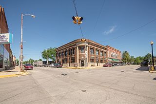
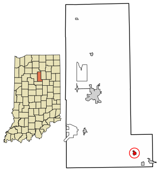
Converse is a town in Jackson Township, Miami County, and Richland Township, Grant County, in the U.S. state of Indiana. The population was 1,161 at the 2020 census.

<span class="mw-page-title-main">Edgewood, Indiana</span> Town in Indiana, United States

Edgewood is a town in Anderson Township, Madison County, Indiana, United States. It is part of the Indianapolis–Carmel–Anderson metropolitan statistical area. The population was 2,053 at the 2020 census.

<span class="mw-page-title-main">Amboy, Indiana</span> Town in Indiana, United States

Amboy is a town in Jackson Township, Miami County, in the U.S. state of Indiana. The population was 317 at the 2020 census, down from 384 in 2010.

<span class="mw-page-title-main">Denver, Indiana</span> Town in Indiana, United States

Denver is a town in Jefferson Township, Miami County, in the U.S. state of Indiana. The population was 478 at the 2020 census.

<span class="mw-page-title-main">Macy, Indiana</span> Town in Indiana, United States

Macy is a town in Allen Township, Miami County, in the U.S. state of Indiana. The population was 199 at the 2020 census.

<span class="mw-page-title-main">Linden, Indiana</span> Town in Indiana, United States

Linden is a town in Madison Township, Montgomery County, in the U.S. state of Indiana. The population was 711 at the 2020 census.

<span class="mw-page-title-main">Bloomingdale, Indiana</span> Town in Indiana, United States

Bloomingdale is a town in Penn Township, Parke County, in the U.S. state of Indiana. The population was 335 at the 2010 census.

<span class="mw-page-title-main">Fillmore, Indiana</span> Town in Indiana, United States

Fillmore is a town in Marion Township, Putnam County, in the U.S. state of Indiana. The population was 532 at the 2020 census.

<span class="mw-page-title-main">Clear Lake, Indiana</span> Town in Indiana, United States

Clear Lake is a town located in the northeast corner of Steuben County, Indiana, in Clear Lake Township. As such, is the northeasternmost community in the State of Indiana. The population was 339 at the 2010 census.

<span class="mw-page-title-main">Clarks Hill, Indiana</span> Town in Indiana, United States

Clarks Hill is a town in Lauramie Township, Tippecanoe County, in the U.S. state of Indiana. The population was 611 at the 2010 census.

<span class="mw-page-title-main">Lagro, Indiana</span> Town in Indiana, United States

Lagro is a town in Lagro Township, Wabash County, in the U.S. state of Indiana. The population was 415 at the 2010 census.

<span class="mw-page-title-main">Ludlow Falls, Ohio</span> Village in Ohio, United States

Ludlow Falls is a village in Miami County, Ohio, United States. The population was 175 at the 2020 census. It is part of the Dayton Metropolitan Statistical Area. Ludlow Falls is named after surveyor Israel Ludlow.

<span class="mw-page-title-main">Bunker, Missouri</span> City in Missouri, United States

Bunker is a town in Dent and Reynolds counties in the U.S. state of Missouri. The population was 295 at the 2020 census.

<span class="mw-page-title-main">Meridian Hills, Indiana</span> Town in Indiana, United States

Meridian Hills is a town in Washington Township, Marion County, Indiana, about 8 miles (13 km) north of downtown Indianapolis. It had a population of 1,774 at the 2020 census, up from 1,616 in 2010.

<span class="mw-page-title-main">Williams Creek, Indiana</span> Town in Indiana, United States

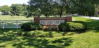
Williams Creek is a town in Washington Township, Marion County, Indiana, United States. It is located about 9 miles (14 km) north of downtown Indianapolis. The population was 430 at the 2020 census. It has existed as an "included town" since 1970, when it was incorporated into Indianapolis as part of Unigov. It is part of Indianapolis, but retains a functioning town government under IC 36-3-1-11.

References

  1. 1 2 "2022 U.S. Gazetteer Files: Indiana". United States Census Bureau. Retrieved April 18, 2023.
  2. 1 2 3 U.S. Geological Survey Geographic Names Information System: Bunker Hill, Indiana
  3. 1 2 "P1. Race – Bunker Hill town, Indiana: 2020 DEC Redistricting Data (PL 94-171)". U.S. Census Bureau. Retrieved April 18, 2023.
  4. 1 2 "U.S. Census website". United States Census Bureau . Retrieved January 31, 2008.
  5. "P1. Race – Bunker Hill town, Indiana: 2010 DEC Redistricting Data (PL 94-171)". U.S. Census Bureau. Retrieved April 18, 2023.
  6. History of Miami County, Indiana: From the Earliest Time to the Present. Brant & Fuller. 1887. p. 745.
  7. Bodurtha, Arthur Lawrence (1914). History of Miami County, Indiana: A Narrative Account of Its Historical Progress, Its People and Its Principal Interests. Lewis Pub. p. 182.
  8. "Census of Population and Housing". Census.gov. Retrieved June 4, 2015.
  9. "U.S. Census website". United States Census Bureau . Retrieved December 11, 2012.