Deer Creek Township, Miami County, Indiana

Last updated
Deer Creek Township
Deer Creek Township soybean field from SR18.jpg
Soybean fields west of U.S. Route 31
Map highlighting Deer Creek Township, Miami County, Indiana.svg
Location in Miami County
Coordinates: 40°36′34″N86°07′52″W / 40.60944°N 86.13111°W / 40.60944; -86.13111 Coordinates: 40°36′34″N86°07′52″W / 40.60944°N 86.13111°W / 40.60944; -86.13111
Country Flag of the United States.svg  United States
State Flag of Indiana.svg  Indiana
County Miami
Government
  Type Indiana township
Area
  Total23.78 sq mi (61.6 km2)
  Land23.76 sq mi (61.5 km2)
  Water0.02 sq mi (0.05 km2)  0.08%
Elevation
[1]
787 ft (240 m)
Population
 (2010)
  Total4,839
  Density203.7/sq mi (78.6/km2)
Time zone UTC-5 (Eastern (EST))
  Summer (DST) UTC-4 (EDT)
ZIP codes
46901, 46914, 46932, 46959
GNIS feature ID 453259

Deer Creek Township is one of fourteen townships in Miami County, Indiana, United States. As of the 2010 census, its population was 4,839 and it contained 745 housing units. [2] The south quarter of the Grissom Joint Air Reserve Base is located in this township.

Contents

History

Deer Creek Township was organized in 1845. [3] Deer Creek takes its name from the stream that flows a westerly course through the center of the township. [4]

Geography

According to the 2010 census, the township has a total area of 23.78 square miles (61.6 km2), of which 23.76 square miles (61.5 km2) (or 99.92%) is land and 0.02 square miles (0.052 km2) (or 0.08%) is water. [2]

Unincorporated towns

(This list is based on USGS data and may include former settlements.)

Cemeteries

The township contains seven historical pioneer cemeteries, several dating back to the 1830s through the 1850s:

Cassville Cemetery - In the southwest corner of section 31 on the north side of Cassville, Howard County on the east side of US Highway 31.
Chittick Cemetery - In the northeast corner of section 29; one and a half miles east of Bennett's Switch north of State Road 18 on 100W.
Deer Creek Baptist Cemetery - On the north side of section 23 south of Deer Creek, south of 1100S at about 450W. This was once the churchyard of the Deer Creek Baptist Church formed in 1849.
Old Miami Cemetery - In section 17 about one-half mile east of Miami, south side of Deer Creek.
Railside Chapel Cemetery - East of US Highway 31 on 800S, south side of road on west side of railroad between railroad tracks and 150W. Triangular patch being farmed, no markers or physical appearance of a burial ground.
Reed/Gettinger Cemetery - In section 18 southwest of Miami and one half-mile east of US Highway 31, south side Deer Creek.
Waisner-Rickard Cemetery - In section 36, northwest of 1400S and 400W fourth-fifths of a mile east of Cass County line and about one-fourth of a mile north of the Howard County line on a small knoll / hill, south side Deer Creek in the area of Lot 78, Deer Creek Estates; no surface monuments remain. Thomas Martindale received patent for the land where the cemetery was in 1848 - the burial ground appearing in the deed abstracts from 1853 through 1901. The first known burial was in 1846 of Anthony Rickard and the last known in 1860, Jacob Waisner. Martindale was squatting on the land as early as 1845 and sponsored gatherings of the "New-Light" Christian Church on his property during the duration of the burial ground's use. The congregation bought property and relocated to the nearby village of Cassville in 1860; their relocation seems to coincide with the abandonment of the burial ground as members were buried in the closer Cassville Cemetery immediately thereafter.

Major highways

School districts

Political districts

Related Research Articles

<span class="mw-page-title-main">Miami County, Indiana</span> County in Indiana, United States

Miami County is a county located in the U.S. state of Indiana. As of 2010, the population was 36,903. The county seat is the City of Peru. Miami County is part of the Kokomo-Peru CSA.

<span class="mw-page-title-main">Howard County, Indiana</span> County in Indiana, United States

Howard County is one of 92 counties in the U.S. state of Indiana. As of the 2020 census, the population was 83,658. The county seat is Kokomo. Originally named Richardville County, it was renamed in 1844 to commemorate General Tilghman Ashurst Howard.

<span class="mw-page-title-main">Urbana Township, Champaign County, Illinois</span> Township in Illinois, United States

Urbana Township is a township in Champaign County, Illinois, USA. As of the 2010 census, its population was 7,451 and it contained 3,435 housing units.

<span class="mw-page-title-main">Cicero Township, Tipton County, Indiana</span> Township in Indiana, United States

Cicero Township is one of six townships in Tipton County, Indiana, United States. As of the 2010 census, its population was 8,086 and it contained 3,646 housing units. It is the largest of the six townships in the county.

<span class="mw-page-title-main">Jefferson Township, Tipton County, Indiana</span> Township in Indiana, United States

Jefferson Township is one of six townships in Tipton County, Indiana, United States. As of the 2010 census, its population was 1,422 and it contained 616 housing units.

<span class="mw-page-title-main">Prairie Township, Tipton County, Indiana</span> Township in Indiana, United States

Prairie Township is one of six townships in Tipton County, Indiana, United States. As of the 2010 census, its population was 1,140 and it contained 482 housing units.

<span class="mw-page-title-main">Monon Township, White County, Indiana</span> Township in Indiana, United States

Monon Township is one of twelve townships in White County, Indiana, United States. As of the 2010 census, its population was 3,282 and it contained 2,032 housing units.

<span class="mw-page-title-main">Forest Township, Clinton County, Indiana</span> Township in Indiana, United States

Forest Township is one of fourteen townships in Clinton County, Indiana. As of the 2010 census, its population was 760 and it contained 328 housing units. The township was named for the large amount of timber it contained at the time it was organized.

<span class="mw-page-title-main">Lauramie Township, Tippecanoe County, Indiana</span> Township in Indiana, United States

Lauramie Township is one of thirteen townships in Tippecanoe County, Indiana, United States. As of the 2010 census, its population was 2,596 and it contained 1,021 housing units.

<span class="mw-page-title-main">Tippecanoe Township, Tippecanoe County, Indiana</span> Township in Indiana, United States

Tippecanoe Township is one of thirteen townships in Tippecanoe County, Indiana, United States. As of the 2010 census, its population was 7,702 and it contained 3,085 housing units.

<span class="mw-page-title-main">Washington Township, Tippecanoe County, Indiana</span> Township in Indiana, United States

Washington Township is one of thirteen townships in Tippecanoe County, Indiana, United States. As of the 2010 census, its population was 2,432 and it contained 1,002 housing units.

<span class="mw-page-title-main">Deer Creek Township, Cass County, Indiana</span> Township in Indiana, United States

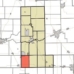
Deer Creek Township is one of fourteen townships in Cass County, Indiana. As of the 2010 census, its population was 912.

<span class="mw-page-title-main">Jackson Township, Cass County, Indiana</span> Township in Indiana, United States

Jackson Township is one of fourteen townships in Cass County, Indiana. As of the 2010 census, its population was 2,876.

<span class="mw-page-title-main">Tipton Township, Cass County, Indiana</span> Township in Indiana, United States

Tipton Township is one of fourteen townships in Cass County, Indiana, United States. As of the 2010 census, its population was 2,490.

<span class="mw-page-title-main">Washington Township, Cass County, Indiana</span> Township in Indiana, United States

Washington Township is one of fourteen townships in Cass County, Indiana, and one of the forty-six townships sharing the name in the state. As of the 2010 census, its population was 1,608.

<span class="mw-page-title-main">Pipe Creek Township, Miami County, Indiana</span> Township in Indiana, United States

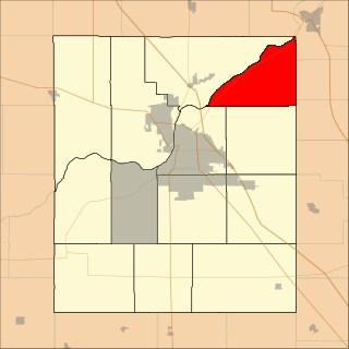
Pipe Creek Township is one of fourteen townships in Miami County, Indiana, United States. As of the 2010 census, its population was 6,294 and it contained 2,936 housing units. The north three-quarters of Grissom Joint Air Reserve Base is in the southwest corner of the township.

<span class="mw-page-title-main">Howard Township, Howard County, Indiana</span> Township in Indiana, United States

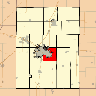
Howard Township is one of eleven townships in Howard County, Indiana, United States. As of the 2010 census, its population was 2,579 and it contained 1,072 housing units.

<span class="mw-page-title-main">Clear Creek Township, Monroe County, Indiana</span> Township in Indiana, United States

Clear Creek Township is one of eleven townships in Monroe County, Indiana, United States. As of the 2010 census, its population was 5,000 and it contained 2,674 housing units.

<span class="mw-page-title-main">Washington Township, Wayne County, Indiana</span> Township in Indiana, United States

Washington Township is one of fifteen townships in Wayne County, Indiana, United States. As of the 2010 census, its population was 1,436 and it contained 626 housing units.

Waisner-Rickard Cemetery is a one-acre neglected and abandoned pioneer cemetery located in Deer Creek Township, Miami, Indiana, United States described as being on the top of a knoll to the south of South Fork Deer Creek. The site is about a quarter of a mile north of the Daniel Rickard Homestead that was just across the Miami County line in Clay Township, Howard County, Indiana. The earliest known burial was Anthony Rickard, the father of Daniel Rickard, who died October 8, 1846. The site was a community burial ground that served residents in southern Deer Creek Township as well as Clay and Howard Townships in nearby Howard County, Indiana to about 1860.

References

  1. "US Board on Geographic Names". United States Geological Survey. October 25, 2007. Retrieved 2017-05-09.
  2. 1 2 "Population, Housing Units, Area, and Density: 2010 - County -- County Subdivision and Place -- 2010 Census Summary File 1". United States Census. Archived from the original on 2020-02-12. Retrieved 2013-05-10.
  3. History of Miami County, Indiana: From the Earliest Time to the Present. Brant & Fuller. 1887. pp.  278.
  4. Bodurtha, Arthur Lawrence (1914). History of Miami County, Indiana: A Narrative Account of Its Historical Progress, Its People and Its Principal Interests. Lewis Pub. pp.  121.