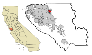
Demographics
Historical population| Census | Pop. | Note | %± |
|---|
| 2020 | 4,940 | | — |
|---|
|
2010
The 2010 United States Census [5] reported that Burbank had a population of 4,926. The population density was 12,218.4 inhabitants per square mile (4,717.6/km2). The racial makeup of Burbank was 2,994 (60.8%) White, 135 (2.7%) African American, 64 (1.3%) Native American, 379 (7.7%) Asian, 16 (0.3%) Pacific Islander, 1,049 (21.3%) from other races, and 289 (5.9%) from two or more races. Hispanic or Latino of any race were 2,509 persons (50.9%).
The Census reported that 100% of the population lived in households.
There were 1,877 households, out of which 620 (33.0%) had children under the age of 18 living in them, 688 (36.7%) were opposite-sex married couples living together, 267 (14.2%) had a female householder with no husband present, 135 (7.2%) had a male householder with no wife present. There were 175 (9.3%) unmarried opposite-sex partnerships, and 40 (2.1%) same-sex married couples or partnerships. 562 households (29.9%) were made up of individuals, and 92 (4.9%) had someone living alone who was 65 years of age or older. The average household size was 2.62. There were 1,090 families (58.1% of all households); the average family size was 3.32.
The population was spread out, with 1,125 people (22.8%) under the age of 18, 485 people (9.8%) aged 18 to 24, 1,737 people (35.3%) aged 25 to 44, 1,273 people (25.8%) aged 45 to 64, and 306 people (6.2%) who were 65 years of age or older. The median age was 34.5 years. For every 100 females, there were 100.9 males. For every 100 females age 18 and over, there were 100.9 males.
There were 1,982 housing units at an average density of 4,916.1 per square mile (1,898.1/km2), of which 823 (43.8%) were owner-occupied, and 1,054 (56.2%) were occupied by renters. The homeowner vacancy rate was 2.0%; the rental vacancy rate was 3.3%. 2,194 people (44.5% of the population) lived in owner-occupied housing units and 2,732 people (55.5%) lived in rental housing units.
2000
As of the census [6] of 2000, there were 5,239 people, 2,027 households, and 1,141 families residing in the CDP. The population density was 11,748.6 inhabitants per square mile (4,536.2/km2). There were 2,063 housing units at an average density of 4,626.4 per square mile (1,786.3/km2). The racial makeup of the CDP was 63.52% White, 2.94% African American, 0.84% Native American, 6.74% Asian, 0.57% Pacific Islander, 19.81% from other races, and 5.57% from two or more races. Hispanic or Latino of any race were 43.12% of the population.
There were 2,027 households, out of which 29.6% had children under the age of 18 living with them, 36.9% were married couples living together, 12.6% had a female householder with no husband present, and 43.7% were non-families. 32.7% of all households were made up of individuals, and 6.4% had someone living alone who was 65 years of age or older. The average household size was 2.58 and the average family size was 3.32.
In the CDP, the population was spread out, with 24.8% under the age of 18, 8.8% from 18 to 24, 39.7% from 25 to 44, 19.4% from 45 to 64, and 7.3% who were 65 years of age or older. The median age was 33 years. For every 100 females, there were 102.6 males. For every 100 females age 18 and over, there were 100.2 males.
The median income for a household in the CDP was $47,226, and the median income for a family was $51,769. Males had a median income of $43,672 versus $32,431 for females. The per capita income for the CDP was $23,232. About 7.2% of families and 10.8% of the population were below the poverty line, including 11.5% of those under age 18 and 4.9% of those age 65 or over.
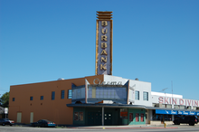
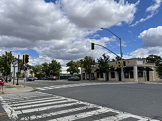
Government
At the county level, Burbank is located within the 4th supervisorial district, represented on the Santa Clara County Board of Supervisors by Ken Yeager. In the California State Legislature, Burbank is in the 15th Senate District , represented by Democrat Dave Cortese, and in the 28th Assembly District , represented by Democrat Gail Pellerin. [7] In the United States House of Representatives, Burbank is in California's 18th congressional district , represented by Democrat Zoe Lofgren. [8]
The area has been defined by several political entities since 1906 beginning with the Burbank School District, and shortly afterward the Burbank Fire District, which expanded the community far beyond its traditional, political and unofficial boundaries. The Burbank Sanitary District and later the Burbank Community Advisory Council became identifying local political entities.
Burbank Sanitary District
The Burbank Sanitary District operates the sewer collection lines, handles waste collection and street sweeping. Established in 1940, the Sanitary District is the only local government, other than LBSD, specific to the neighborhood. The District is governed by a Board of five members, elected to four-year terms, which meets monthly. Legal and engineering services, as well as all construction and maintenance, are contracted out. [9]
Sewer services are provided to other unincorporated areas of the Burbank Community by the West Valley Sanitation District, an independent sanitation district that also services neighboring cities and unincorporated areas. Waste collection in the other areas are the jurisdiction of the County of Santa Clara. Sewage treatment is provided by the San Jose/Santa Clara Water Pollution Control Plant a joint powers agency of which both districts are members. [10]

Cherryland is an unincorporated community and census-designated place (CDP) in Alameda County, California, United States. Cherryland is located between Ashland to the north and the city of Hayward to the south. The population was 15,808 at the 2020 census.

Sunol is an unincorporated area and census-designated place in Alameda County, California. Located in the Sunol Valley of the East Bay, the population was 913 at the 2010 census. It is best known as the location of the Sunol Water Temple and for its historic tourist railroad system, the Niles Canyon Railway.
Middletown is a census-designated place (CDP) in Lake County, California, United States. Its population was 725 at the 2020 census down from 1,323 at the 2010 census, which was up slightly from 1,020 at the 2000 census. Middletown was given its name because it is halfway between Lower Lake and Calistoga, which is 17 miles (27 km) to the south. The town was severely damaged by the 2015 Valley Fire.

Santa Venetia is a census-designated place (CDP) in Marin County, California, United States. It is located 1.5 miles (2.4 km) north of downtown San Rafael, at an elevation of 56 feet (17 m). The population was 4,289 at the 2020 census.

Aromas is an unincorporated community and census-designated place (CDP) in Monterey County and San Benito County, California, United States. The population was 2,708 at the 2020 census.

Wrightwood is a census-designated place in San Bernardino County, California. It sits at an elevation of 6,208 feet (1,892 m). The population was 4,525 at the 2010 census, up from the population of 3,837 at the 2000 census. Wrightwood is located 77 miles (124 km) northeast of Los Angeles. Wrightwood is on the Pacific Crest Trail.

Lake San Marcos is a unincorporated community in the North County region of the San Diego metropolitan area. For statistical purposes, the United States Census Bureau has defined the community as a census-designated place (CDP). Surrounded by the city of San Marcos, the county-governed area receives certain services from the city.

West Menlo Park is a census-designated place and an Unincorporated community in San Mateo County, California, located between the majority of City of Menlo Park, the Town of Atherton, the Sharon Heights neighborhood of Menlo Park and Stanford University. As of the 2020 census, the community had a population of 3,930.

Buena Vista is a former census-designated place (CDP) in Santa Clara County, California, United States. The population was 1,704 at the 2000 census. The area is now part of the city of San Jose.

Cambrian is a neighborhood of San Jose, California, located in South San Jose. Though most of the neighborhood is incorporated as part of San Jose, a small portion exists as an unincorporated census-designated place called Cambrian Park.
East Foothills is a census-designated place (CDP) in Santa Clara County, California, United States and a neighborhood of San Jose. The population was 8,269 at the 2010 census and it is located about 4 miles east of downtown San Jose.
Fruitdale is a district of San Jose, California, though some portions are still unincorporated as a census-designated place. The population of the CDP was 935 at the 2010 census.

Loyola is a census-designated place in Santa Clara County, California, United States. The population was 3,491 at the 2020 census. It was ranked as one of the wealthiest neighborhoods in America, with homes ranging from cottages to sprawling ranch houses and mansions. The woodsy area is the home of the Los Altos Golf & Country Club and is located between the city of Los Altos and the town of Los Altos Hills. It is also the home of the Facebook House. The neighborhood is named for Ignatius of Loyola, a Spanish saint and founder of the Jesuits.

San Martin or San Martín is a village and census-designated place (CDP) in Santa Clara County, California, in the southern Santa Clara Valley. Located to the south of Morgan Hill and north of Gilroy, San Martin is characterized by ranches, wineries, and orchards, as well as large estates in the foothills of the Santa Cruz Mountains.
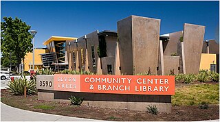
Seven Trees is a Neighborhood of San Jose, California. It was formerly an unincorporated census-designated place surrounded completely by South San Jose and it was annexed into San Jose on November 23, 2009.

Stanford is a census-designated place (CDP) in the northwest corner of Santa Clara County, California, United States. It is the home of Stanford University. The population was 21,150 at the 2020 census.

Midtown San Jose is a mixed commercial and residential district of San Jose, California, to the southwest of Downtown San Jose and east of West San Carlos.

Felton is a census-designated place (CDP) in Santa Cruz County, California, United States. The population was 4,489 as of 2020 census and according to the United States Census Bureau, the CDP has a total area of 4.6 square miles (12 km2), all of it land.

El Rio is a small, rural unincorporated town in Ventura County, California, United States, on the northeast side of the 101 Freeway and Oxnard, and south of the Santa Clara River. The town was founded in 1875 and named New Jerusalem by the owner of general store who became the first postmaster in 1882. In 1885, a school and Santa Clara Catholic Church were built. Located near where the coastal railroad line crosses the Santa Clara River, the town's name was changed to El Rio around 1900. The former wagon river crossing route became the Ventura Freeway which separates the community from the commercial developments that grew up on the southwest side of the freeway. That portion of the historic community and sections closer to the river have been annexed to the city of Oxnard. Vineyard Avenue is the central business district for the largely residential community.

Larkfield-Wikiup is a census-designated place unincorporated area in Sonoma County, California, United States. The population was 8,884 at the 2010 census, up from 7,479 at the 2000 census. It comprises the Mark West area between Santa Rosa, Windsor (north), Calistoga (east), and Fulton (west). There are at least four schools within the limits of the CDP, including Cardinal Newman High School, John B. Riebli Elementary School, Mark West Elementary, and San Miguel Elementary schools.