The National Weather Service maintained a cooperative weather station on the site of Wrights until May 31, 1986, which recorded rainfall and snowfall.[3] The weather station was 1,600 feet (490m) above sea level.[4] The location is on the San Andreas Fault, according to the U.S. Geological Survey, and it experienced considerable damage in the 1906 San Francisco earthquake.[5] Geologists observed a lateral displacement of 4.6 feet (1.4m) at Wrights.[6]
Wrights is one of a number of ghost towns in the Santa Cruz Mountains that flourished during the last half of the nineteenth century. Laurel, Wrights, Glenwood, and Clems declined when the Los Gatos-Santa Cruz railroad ceased operations in March 1940. Later in 1940, Patchen was bypassed and isolated by the construction of State Route 17; since the late 1960s it has been a Christmas tree ranch. Alma and Lexington were submerged in Lexington Reservoir in 1952, along State Route 17 above Los Gatos.
History
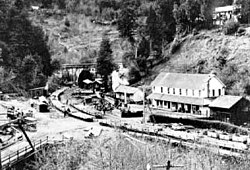
Wrights Station, 1907. Wrights Tunnel in background. Same bridge as below.Wrights Tunnel north portal condition after the caving in blast, Wrights Station, Jan 2009
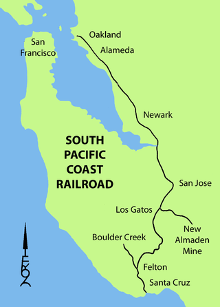
In the 1870s a toll road was built over the mountains from Los Gatos to Santa Cruz that was utilized by stagecoaches. Then, a narrow gauge railroad from Alameda was constructed along the same route, beginning in 1877, by San Francisco capitalists James Fair and Alfred E. Davis, who headed the South Pacific Coast Railroad (SPCRR). One of the stops along the line, just below the summit of the Santa Cruz Mountains, was adjacent to the property of James Richards Wright, who had a residence/hotel known as Arbor Villa in Burrell near the summit, and he maintained commercial orchards of fruit trees and grapes.[7] The small community that sprouted around this stop on the railroad became known as Wright's Station, or simply Wrights. The Rev. Wright was the patriarch of a large family that had moved to California from Ohio and the younger brother of the well-known abolitionist Elizur Wright. One of his sons, Frank Vincent Wright, later married Susie Davis, the daughter of SPCRR president Alfred Davis, and another son, Sumner Banks Wright, moved to southern California and established a town in the San Bernardino mountains known as Wrightwood, today a ski resort.
A post office was established at Wrights in 1879, and the railroad was completed in 1880 from Los Gatos, along the Los Gatos Creek, to Wrights Station, about a mile east of Patchen.[8] During the construction of Wrights Tunnel (between Wrights and Laurel), a strong flow of natural gas was encountered, and an explosion followed, which resulted in the death of thirty-two Chinese workers. The main leak was subsequently stopped, but gas continued to escape in small quantities. The extent of the supply was unknown.[9]U.S. Geological Survey maps from 1919 show the railroad running from Los Gatos to Santa Cruz, with stops in Alma, Wrights, Laurel, Glenwood, Clems, Zayante, Eccles, Felton, and Scotts Valley. There were a series of tunnels, including a 6,200-foot (1,900m) tunnel between Wright and Laurel, most of which were later blocked when the railroad ceased operations. Wrights itself had a benchmark elevation of 896 feet (273m).[10]
Wrights Station was an important shipping point for extensive fruit growing areas in the Santa Cruz mountains. By the 1890s, there were about 3,200 acres (13km2) under cultivation. The soil consists largely of disintegrated sandstone and clay, and has the appearance, particularly on the hilltops, of the "white ash" soil of the Fresnoraisin district.
Vineyards were planted, providing grapes for commercial wine producers, such as Almaden Vineyards and Paul Masson. There was a thriving timber industry, too, utilizing the redwoods of the Santa Cruz Mountains. All utilized the railroad. Wrights Station was one of the small settlements that grew up along the railroad.[9]
Alice Matty and her father, Antone, came to Wrights in 1880 from San Francisco. Her father was originally from the Maritime Alps region of France. Antone Matty worked in the general store for eight years. An overheated stove in the town's hotel started a fire in 1885 that leveled the entire settlement. While Wrights was being rebuilt, Antone ran the store from a boxcar parked on the railroad siding.
In 1887, journalist Josephine McCracken visited Wrights (as it was commonly called), reporting the community had "a depot, hotel, store, post office, blacksmith shop, besides a number of decidedly ugly and disgraceful-looking Chinese stores and wash houses. Fir-crowned mountains frowned down upon it, and the hideous black mouth of the great tunnel close by is always wide open, with the evident and determined intention of swallowing up the train – engine, cars, and all – as it approached from the San Francisco side."
A steam locomotive exiting the Summit Tunnel portal in 1895 in Wrights
By 1888, Antone Matty had saved enough money to buy the store, and by 1896 he owned the town. Since the Matty family had six children, Matty helped to organize a school district, and soon the town had a school. The Wright School was a shingle-walled building with a belfry, and was in operation until 1928. Highlands School was built to replace The Wrights School in 1929. Highlands school was attended by the Children of Wrights Agricultural Farmers. Farmers such as William Elza Lawrence, a turkey farmer and father of 8 children. Elza's children Eluyn (Elvyn) Lawrence, J P Lawrence, Joe Lawrence, Flossie Lawrence and Bessie Lawrence attended Highlands School. Elza's youngest daughter Marie Dell Lawrence was born in Wrights on September 14, 1934. Elza's 9th child was also born in Wright but died shortly after birth and was laid to rest at the Santa Cruz County Graveyard.
The Highlands School was closed after only 10 years of operation. The population dropped steeply in Wrights due to the routing of State Route 17 away from Wrights and instead through Los Gatos to Santa Cruz. Antone Matty became a member of the Santa Clara Valley Pioneer Association, and later joined the Sempervirens Club, a conservation organization devoted to saving the redwoods.
Southern Pacific Railroad bought the narrow gauge SPCRR railroad and decided to take advantage of a craze for picnic excursion trains. They opened a short spur line along the creek at Wrights. They named the area "Sunset Park", and began hauling trainloads of passengers into the Santa Cruz mountains. Unfortunately, according to contemporary reports, the visitors gathered armloads of ferns and wildflowers, left a trail of discarded litter strewn along the railroad right-of-way, and kicked out the passenger car windows on the return trip. The 1906 earthquake ended the excursion trains and Sunset Park.
Damage caused to the Summit Tunnel by the 1906 San Francisco Earthquake, with the north tunnel portal and Wrights just outside of that portalCrew repairing the tunnel after the earthquake and widening the tunnel to allow the tracks to be regauged from narrow gauge to standard gauge
Besides the numerous farms in the region, a number of homes were constructed, many of which were destroyed in the April 18, 1906, earthquake. A fissure opened under the house at the Morrell Ranch, throwing the structure from its foundation and splitting it in two. The quake also destroyed a number of bridges, damaged the tunnels, and twisted the rails, as Robert Iacopi and William Bronson recounted in their published accounts. Another large fissure opened in the dirt road near the blacksmith shop. About 400 feet from the eastern end of the 6,200 feet (1.9km) railroad tunnel (between Wrights and Laurel), a 5-foot (150cm) offset occurred, badly damaging the tunnel. Fences were also split.[11]
Alice Matty, her sisters Teresa and Anna, and her three brothers grew up at Wrights. When the station agent, Mr. Hunter, was replaced in the 1900s, Alice was appointed to take over his position, becoming the first woman station agent hired by Southern Pacific in California. Bruce MacGregor described the job: "The Wrights station agent inked in waybills for loadings of hay, beans, prunes and figs, cargo that would fill two or three boxcars a day. The lumber freighting eclipsed all other cargoes combined." There was a daily freight train from Alameda. Several local freights and mixed trains (passengers and freight) passed through Wrights every day on their way to Santa Cruz or San Jose.
Besides preparing waybills, Alice Matty was the telegrapher and the ticket agent. She handled the manual signal levers that threw the switches when trains needed to be taken off the main line and placed on sidings. Located in the bottom of a canyon, Wrights had its share of flash floods, rock slides, and forest fires. Alice frequently had to telegraph for a repair crew to clear rocks from the track, or shore up a sagging roadbed after a heavy storm. Increasing rail traffic resulted in an increase in the number of accidents.
Alice Matty never married; she stayed at Wrights with her father, who lived until 1922. In later years she worked at the Bank of America in Los Gatos, when it was located at the corner of Main Street and Santa Cruz Avenue.[12]
The railroad was rebuilt after the earthquake, only to cease operations in 1940 following a landslide caused by heavy rains in February of that year. This disaster further contributed to the decline of Wrights (the post office had already closed two years before). With both the post office and school closing in 1938 and frequently no road access due to landslides(closing both roads and rails), farmers such as William Elza Lawrence could not sell their goods. Many of these farmers left Wrights without being able to sell their farms. The routing of State Route 17 away from Wrights in 1940 completed to the village's demise. Sadly also in 1940 Arbor Villa, the Wright family home, which was still occupied by Clara Wright, the youngest daughter of James Richards Wright, burned to the ground and was never rebuilt.
Legacy
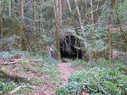
Site of Wrights, May 2008. Some foundations can be seen in the woods, but little remains of the town.
Wrights has so completely disappeared that today no trace remains, except the ruins of the old tunnel. Some building foundations and debris from the town can still be found in the dense woods. Satellite and ground photographs show thick overgrowth and forest on the site. The surrounding area is now only sparsely settled. The name of the community lives on in "Wrights Station Road", which runs through the redwood forest from Morrill Road to Cathermola Road (also known as Metcalf Road on some maps), north of Summit Road. Wrights Station Road crosses Los Gatos Creek on an historic bridge with iron railings (possibly dating from the 1920s), ending at the site of the town. Lake Elsman, a reservoir, is near the site of Wrights. Several miles of the original Los Gatos – Santa Cruz narrow gauge railroad have been preserved in Santa Cruz County and trains operate year-round as a tourist attraction known as the Santa Cruz, Big Trees and Pacific Railway.
Weather station
The National Weather Service cooperative station, which operated on the site of Wrights until 1986, primarily recorded rainfall and snowfall. Based on those observations, Wrights had an average annual rainfall of 46.09 inches (117.1cm) and an average annual snowfall of 1.2 inches (3.0cm). The maximum annual rainfall was 87.65 inches (222.6cm) in 1983 and the minimum was 17.88 inches (45.4cm) in 1976. The greatest 24-hour rainfall was 13.79 inches (35.0cm) on October 12, 1962, during the famous Columbus Day storm that affected much of northern California, Oregon, and Washington. The maximum annual snowfall was 10.6 inches (27cm) in 1974. Some temperature records for Wrights exist, showing a record high of 102°F on August 5, 1978.[13]
Los Gatos is an incorporated town in Santa Clara County, California, United States. The population is 33,529 according to the 2020 census. It is located in the San Francisco Bay Area just southwest of San Jose in the foothills of the Santa Cruz Mountains. Los Gatos is part of Silicon Valley, with several high technology companies maintaining a presence there. Notably, Netflix, the streaming service and content creator, is headquartered in Los Gatos and has developed a large presence in the area.
The Santa Cruz Mountains are a mountain range in central and Northern California, United States, constituting a part of the Pacific Coast Ranges. They form a ridge down the San Francisco Peninsula, south of San Francisco. They separate the Pacific Ocean from the San Francisco Bay and the Santa Clara Valley, and continue south to the Central Coast, bordering Monterey Bay and ending at the Salinas Valley. The range passes through the counties of San Mateo, Santa Clara, and Santa Cruz, with the Pajaro River forming the southern boundary.
James Graham Fair was an Irish immigrant to the United States who became a highly successful mining engineer and businessman. His investments in silver mines in Nevada made him a millionaire, and he was one of the famous "silver kings" who became wealthy on the Comstock Lode. Fair later became a real estate investor and railroad builder in California. In 1881, he was elected a United States Senator from Nevada. Nearly all other major so-called robber barons were Protestants while Fair himself died a Roman Catholic though born into poverty to Anglican parents.
Mount Hamilton is a mountain in the Diablo Range in Santa Clara County, California. The mountain's peak, at 4,265 feet (1,300 m), overlooks the heavily urbanized Santa Clara Valley and is the site of Lick Observatory, the world's first permanently occupied mountain-top observatory. The asteroid 452 Hamiltonia, discovered in 1899, is named after the mountain. Golden eagle nesting sites are found on the slopes of Mount Hamilton. On clear days, Mount Tamalpais, the Santa Cruz Mountains, Monterey Bay, the Monterey Peninsula, and even Yosemite National Park are visible from the summit of the mountain.
State Route 17 is a state highway in the U.S. state of California that runs from State Route 1 in Santa Cruz to I-280 and I-880 in San Jose. SR 17, a freeway and expressway, carries substantial commuter and vacation traffic through the Santa Cruz Mountains at Patchen Pass between Santa Cruz and the San Francisco Bay Area.
Lake Hughes is an unincorporated community in northern Los Angeles County, California. It is in the Sierra Pelona Mountains, northwest of Palmdale and north of the Santa Clarita Valley, in the Angeles National Forest. It is on the sag pond waters of Lake Hughes and Elizabeth Lake. The community is rural in character, with a population of 649 in 2010, but also has a strong recreational element centered on the three lakes in the vicinity. The community of Elizabeth Lake is located just east of Lake Hughes, sharing the same ZIP code.
Redwood Estates is a rural unincorporated community along State Route 17 in the coastal Santa Cruz Mountains in Los Gatos, California, United States. The Census Bureau includes it in a census-designated place named Lexington Hills. It lies inside the confines of Santa Clara County. The area is about eight miles from downtown Los Gatos and nine miles from the Santa Cruz County community of Scotts Valley.
The South Pacific Coast Railroad (SPC) was a 3 ft narrow gauge steam railroad running between Santa Cruz, California, and Alameda, with a ferry connection in Alameda to San Francisco. The railroad was created as the Santa Clara Valley Railroad, founded by local strawberry growers as a way to get their crops to market in San Francisco and provide an alternative to the Southern Pacific Railroad. In 1876, James Graham Fair, a Comstock Lode silver baron, bought the line and extended it into the Santa Cruz Mountains to capture the significant lumber traffic coming out of the redwood forests. The narrow-gauge line was originally laid with 52-pound-per-yard (26 kg/m) rail on 8-foot (2.44 m) redwood ties; and was later acquired by the Southern Pacific and converted to 4 ft 8+1⁄2 instandard gauge.
Lexington Reservoir is an artificial lake on the Los Gatos Creek near Los Gatos, California. The James J. Lenihan Dam, a 195 ft (59 m) high, 1,000 ft (300 m) thick earthen dam, forms the third-largest reservoir in Santa Clara County.
Summit is a small unincorporated community more frequently referred to by locals as the Loma Prieta Community located partially in Santa Clara County but predominantly in Santa Cruz County, California, in the mountain ranges of the Santa Cruz Mountains. It lies at the summit along Highway 17 from which is gets its name. Home to a series of abandoned railroad towns and tunnels from the South Pacific Coast Railroad which operated until the 1940s, Public transportation by bus is also no longer available from the Summit Road area. VTA route 76 has been cancelled since June 2010, and the Highway 17 Express only stops in Scotts Valley. It is one of the few places in the San Francisco Bay Area to receive snowfall and the mountain pass which links the Silicon Valley and Monterey Bay is closed at this spot when snowfall is too heavy. The next town to the south is Scotts Valley and to the north Redwood Estates. The area serves as a rest stop with food for people traveling across the mountains.
Laurel is a ghost town in Santa Cruz County, California, United States, in the Santa Cruz Mountains. It is in a valley at an elevation of 900 feet (270 m) above sea level.
Lexington, California, is a ghost town in Santa Clara County, now submerged by the Lexington Reservoir. Originally located along Los Gatos Creek, the town was 550 feet above sea level.
Alma is a ghost town and drowned town in Santa Clara County in California, United States. It lies beneath the waters of the Lexington Reservoir above Los Gatos. The location is latitude 37.18N and longitude 121.98W. It was 551 feet above sea level.
Patchen is a ghost town in the Santa Cruz Mountains, in Santa Clara County, California. It is located along the old Santa Cruz Highway.
Glenwood, California, is an unincorporated area of Santa Cruz County. It is located at coordinates 37°6′29″N121°59′8″W, and is 891 feet above sea level.
Clems, California is a ghost town in Santa Cruz County with an elevation of 790 feet. It is located a latitude 37055N, longitude 1215947W; decimal degrees: latitude 37.09806, longitude -121.99639.
There are 21 routes assigned to the "G" zone of the California Route Marker Program, which designates county routes in California. The "G" zone includes county highways in Monterey, San Benito, San Luis Obispo, Santa Clara, and Santa Cruz counties.
Patchen Pass is a low mountain pass through the Santa Cruz Mountains of California, connecting the Santa Clara Valley to Santa Cruz and the Pacific coast. California State Route 17 traverses the pass at the Santa Clara–Santa Cruz county line, just south where the highway intersects with California State Route 35.
The Suntan Special was a summer excursion train service operated by the Southern Pacific Railroad between San Francisco and Santa Cruz, California, from 1927 to 1959.
The Wrights Tunnel is a railroad tunnel located in the Santa Cruz Mountains in Santa Clara and Santa Cruz Counties, California. Opened in 1880 after almost two years of construction involving numerous fatalities, the tunnel was at one point the longest tunnel in California and one the longest tunnels in the United States. It carried the tracks of the narrow gauge South Pacific Coast Railroad, which ran trains from San Francisco to Santa Cruz until the railroad was acquired by Southern Pacific Railroad, which upgraded the tracks to standard gauge and continued operating trains through the line and its tunnel until a major storm in 1940 washed out certain sections of the track in the Santa Cruz Mountains. After two years of no rail traffic on the line, Southern Pacific abandoned the line. Subsequently, the United States Army Corps of Engineers collapsed both portals with explosives, destroying the northern portal in the process. The interior of the tunnel remains intact along with the south portal, but the conditions of the interior are unknown, particularly since the tunnel crosses the San Andreas Fault and no person has entered the tunnel in the aftermath of the Loma Prieta earthquake.
This page is based on this Wikipedia article Text is available under the CC BY-SA 4.0 license; additional terms may apply. Images, videos and audio are available under their respective licenses.