Burwash Landing

Last updated

Burwash Landing
Burwash Landing.jpg
Location map Yukon 2.png
Red pog.svg
Burwash Landing
Canada location map 2.svg
Red pog.svg
Burwash Landing
Coordinates: 61°21′11″N138°59′12″W / 61.35306°N 138.98667°W / 61.35306; -138.98667
CountryCanada
Territory Yukon
Area
[1]
  Land30.09 km2 (11.62 sq mi)
Elevation
[2]
806 m (2,645 ft)
Population
 (2016) [1]
  Total72
  Density2.4/km2 (6/sq mi)
Time zone UTC−07:00 (MST)

Burwash Landing is a small community, at historical mile 1093 [3] on the Alaska Highway, in Yukon, Canada along the southern shore of Kluane Lake.

Contents

The present location of Burwash Landing was first used as a summer camp by the Southern Tutchone Athabascans until a trading post was built in the early 1900s by the Jacquot brothers.

The majority of the population are Aboriginal peoples, First Nations. The community is the administrative centre of the Kluane First Nation. In addition to the Alaska Highway, the community is served by the Burwash Airport.

It is the home of the Kluane Museum of Natural History and the Kluane First Nation, and also home to the world's largest gold pan.

In July 1937, Robert Bates and Bradford Washburn, two members of the Harvard Mountaineering Club, made their way into Burwash Landing after climbing the 17,146 ft (5,226 m) Lucania peak and hiking over 150 mi (240 km) across the wilderness after their bush pilot was unable to retrieve them. [4]

Geography

Burwash Landing is 2,647 ft (807 m) [2] above sea level at the airport. The elevation can be higher in some places and lower in the others. Burwash Landing is located on the Historic Milepost 1093 Alaska (Alcan) Highway. It sits on the northwest shore of Kluane Lake. Several prominent geographic features have been renamed in Southern Tutchone language.

Climate

Burwash Landing has a typical subarctic climate (Köppen climate classification Dfc), bordering on a dry-winter subarctic climate (Köppen climate classification Dwc). Burwash Landing holds the record for the warmest temperature ever recorded in the Yukon in January at 16.5 °C (61.7 °F), which was set on January 24, 2014. [5] The previous Yukon record of 10.9 °C (51.6 °F), was set in Whitehorse on January 13, 2013. [6] [7]

Climate data for Burwash Airport
MonthJanFebMarAprMayJunJulAugSepOctNovDecYear
Record high humidex 7.111.110.518.728.631.134.331.224.621.010.011.634.3
Record high °C (°F)16.5
(61.7)
12.0
(53.6)
10.5
(50.9)
20.3
(68.5)
29.7
(85.5)
31.7
(89.1)
28.9
(84.0)
30.5
(86.9)
25.5
(77.9)
21.0
(69.8)
10.6
(51.1)
13.5
(56.3)
31.7
(89.1)
Mean daily maximum °C (°F)−14.3
(6.3)
−8.8
(16.2)
−2.3
(27.9)
5.8
(42.4)
12.7
(54.9)
18.0
(64.4)
19.6
(67.3)
17.5
(63.5)
11.3
(52.3)
2.0
(35.6)
−8.8
(16.2)
−11.6
(11.1)
3.4
(38.1)
Daily mean °C (°F)−20.5
(−4.9)
−16.4
(2.5)
−10.8
(12.6)
−1.2
(29.8)
5.7
(42.3)
11.1
(52.0)
13.1
(55.6)
10.9
(51.6)
5.1
(41.2)
−3.4
(25.9)
−14.6
(5.7)
−17.8
(0.0)
−3.2
(26.2)
Mean daily minimum °C (°F)−26.7
(−16.1)
−23.8
(−10.8)
−19.2
(−2.6)
−8.2
(17.2)
−1.4
(29.5)
4.1
(39.4)
6.4
(43.5)
4.2
(39.6)
−1.1
(30.0)
−8.6
(16.5)
−20.3
(−4.5)
−24.0
(−11.2)
−9.9
(14.2)
Record low °C (°F)−55.0
(−67.0)
−55.0
(−67.0)
−48.9
(−56.0)
−35.1
(−31.2)
−13.0
(8.6)
−5.5
(22.1)
−3.3
(26.1)
−8.5
(16.7)
−22.3
(−8.1)
−35.4
(−31.7)
−44.7
(−48.5)
−51.2
(−60.2)
−55.0
(−67.0)
Record low wind chill −63.9−59.9−51.9−38.0−15.6−6.6−4.6−10.5−27.6−44.0−53.0−61.0−63.9
Average precipitation mm (inches)8.4
(0.33)
7.3
(0.29)
6.9
(0.27)
6.8
(0.27)
24.1
(0.95)
49.2
(1.94)
67.9
(2.67)
41.8
(1.65)
25.2
(0.99)
16.1
(0.63)
10.8
(0.43)
10.2
(0.40)
274.7
(10.81)
Average rainfall mm (inches)0.2
(0.01)
0.1
(0.00)
0.0
(0.0)
0.8
(0.03)
16.0
(0.63)
47.9
(1.89)
67.9
(2.67)
41.0
(1.61)
20.0
(0.79)
2.0
(0.08)
0.2
(0.01)
0.0
(0.0)
196.2
(7.72)
Average snowfall cm (inches)12.0
(4.7)
10.4
(4.1)
9.9
(3.9)
7.4
(2.9)
8.8
(3.5)
1.2
(0.5)
0.0
(0.0)
0.8
(0.3)
5.9
(2.3)
18.6
(7.3)
15.8
(6.2)
15.0
(5.9)
105.5
(41.5)
Average precipitation days (≥ 0.2 mm)7.66.85.53.68.310.914.411.09.49.79.87.5104.4
Average rainy days (≥ 0.2 mm)0.10.20.00.56.610.914.410.87.71.70.20.153.2
Average snowy days (≥ 0.2 cm)7.96.85.63.43.00.40.00.22.48.69.97.755.9
Average relative humidity (%)74.568.757.747.242.545.150.651.554.566.077.076.359.3
Source: 1981-2010 Environment Canada [8]

Demographics

Federal census population history of Burwash Landing
YearPop.±%
198173    
198664−12.3%
1991 77+20.3%
1996 58−24.7%
2001 68+17.2%
2006 73+7.4%
2011 95+30.1%
2016 72−24.2%
2021 64−11.1%
Source: Statistics Canada
[9] [10] [11] [12] [13] [1] [14] [15]

In the 2021 Census of Population conducted by Statistics Canada, Burwash Landing had a population of 64 living in 44 of its 52 total private dwellings, a change of

Southern Tutchone people

Burwash landing is the traditional home of the Southern Tutchone Athabascans. It used to be a summer camp. A revival of the Southern Tutchone language and culture has been taking place in this quiet lakeside community. This is readily apparent to visitors when they pull into town and are met with Southern Tutchone street and traffic signs, within and nearby Burwash Landing. Several prominent geographic features have been renamed in Southern Tutchone and signs can be seen along the Alaska (Alcan) Highway.

Burls

Burwash Landing is known for its black spruce burls. Burls start as an irritation in the spruce. The tree sends extra sap as healant, which creates a growth (burl). Burls are either "green," harvested from live trees in the spring, or they are "dry burls," taken from dead burl trees. Burls are peeled off their bark and used in their natural form as fenceposts, for example, or they may be shaped and finished into a variety of objects, such as bowls. Check the Burlbilly Hill on the Milepost 1061.6, the visitor will see rows of "burly logs" on the hill.

Related Research Articles

<span class="mw-page-title-main">Yukon</span> Territory of Canada

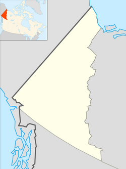
Yukon is the smallest and westernmost of Canada's three territories. It is the second-least populated province or territory in Canada, with a population of 45,148 as of 2023. However, Whitehorse, the territorial capital, is the largest settlement in any of the three territories.

<span class="mw-page-title-main">Beaver Creek, Yukon</span> Place in Yukon, Canada

Beaver Creek is a community in Yukon, Canada. Located at kilometre 1870.6 of the Alaska Highway, 1 NM southeast of Beaver Creek Airport and close to the Alcan - Beaver Creek Border Crossing, it is Canada's westernmost community. The community's main employers are a Canada Border Services Agency port, the White River First Nation and a number of tourist lodges.

<span class="mw-page-title-main">Faro, Yukon</span> Town in Yukon, Canada

Faro is a town in central Yukon, Canada, the home of the now abandoned Faro Mine. It was the largest open-pit lead–zinc mine in the world as well as a significant producer of silver and other natural resources. The mine was built by the Ralph M. Parsons Construction Company of the United States with General Enterprises Ltd. of Whitehorse being the main subcontractor. As of 2021, the population is 440, down from its peak population of 1,652 in 1981. Faro was named after the card game of the same name.

<span class="mw-page-title-main">Carcross</span> Place in Yukon, Canada

Carcross, originally known as Caribou Crossing, is an unincorporated community in Yukon, Canada, on Bennett Lake and Nares Lake. It is home to the Carcross/Tagish First Nation.

<span class="mw-page-title-main">Haines Junction, Yukon</span> Village in Yukon, Canada

Haines Junction is a village in Yukon, Canada. It is at Kilometre 1,632 of the Alaska Highway at its junction with the Haines Highway, hence the name of the community. According to the 2021 Census, the population was 688. However, the Yukon Bureau of Statistics lists the population count for 2022 as 1,018.

<span class="mw-page-title-main">Carmacks, Yukon</span> Village in Yukon, Canada

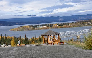
Carmacks is a village in Yukon, Canada, on the Yukon River along the Klondike Highway, and at the west end of the Robert Campbell Highway from Watson Lake. The population is 588, an increase from the Census of 2016. It is the home of the Little Salmon/Carmacks First Nation, a Northern Tutchone-speaking people.

<span class="mw-page-title-main">Watson Lake, Yukon</span> Town in Yukon, Canada

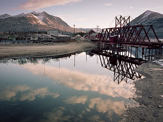
Watson Lake is a town in Yukon, Canada, located at mile 635 on the Alaska Highway close to the British Columbia border. It has a population of 790 in 2016. The town is named for Frank Watson, an American-born trapper and prospector, who settled in the area at the end of the 19th century.

<span class="mw-page-title-main">Mayo, Yukon</span> Village in Yukon, Canada

Mayo is a village in Yukon, Canada, along the Silver Trail and the Stewart River. It had a population of 200 in 2016. The Yukon Bureau of Statistics estimated a population of 496 in 2019. It is also the home of the First Nation of Na-Cho Nyak Dun, whose primary speak the northern variety of the Tutchone language. Na-Cho Nyäk Dun translates into "big river people."

<span class="mw-page-title-main">Teslin, Yukon</span> Village in Yukon, Canada

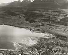
The community of Teslin includes the Village of Teslin in Yukon, Canada. Teslin is situated at historical Mile 804 on the Alaska Highway along Teslin Lake. The Hudson's Bay Company established a small trading post at Teslin in 1903.

Pelly Crossing is a community in Yukon, Canada. It lies where the Klondike Highway crosses the Pelly River.

<span class="mw-page-title-main">Champagne Landing</span> Place in Yukon, Canada

Champagne Landing or Champagne Landing 10 is a First Nations settlement in Yukon, Canada. It is located on the Alaska Highway. Its residents are citizens of the Champagne and Aishihik First Nations.

<span class="mw-page-title-main">Destruction Bay</span> Place in Yukon, Canada

Destruction Bay is a small community on the Alaska Highway in Canada's Yukon on Kluane Lake.

<span class="mw-page-title-main">Ibex Valley, Yukon</span>

Ibex Valley is a hamlet in Canada's Yukon. The hamlet is considered a local advisory area with an advisory council providing local government. Its population in 2021 according to the 2021 Canadian Census was 523.

Marsh Lake is an unincorporated community on the Alaska Highway on the shores of Marsh Lake southeast of Whitehorse in Canada's Yukon. The area was organized in 2001, as a local area council to help the residents with some form of municipal government.

Upper Liard is a chiefly First Nation settlement immediately west of Watson Lake in Canada's Yukon. It is situated at historical mile 642 of the Alaska Highway. Most of the residents are citizens of the Liard River First Nation, who also prominently populate the Two Mile area just north of Watson Lake.

<span class="mw-page-title-main">Johnsons Crossing</span> Settlement in Yukon, Canada

Johnsons Crossing or Johnson's Crossing is a settlement in Yukon, Canada. It is located at historical mile 836 of the Alaska Highway, at the junction of the Canol Road where the highway crosses the Teslin River.

<span class="mw-page-title-main">Stewart Crossing</span> Settlement in Yukon, Canada

Stewart Crossing is a settlement in Yukon, Canada located on the Stewart River. It is about 179 km east of Dawson City on the Klondike Highway, near the junction with the Silver Trail, from which it is about 53 km (33 mi) southwest of Mayo. A Yukon government highway maintenance camp and a highway lodge are the most prominent facilities at Stewart Crossing. The settlement is named for where the Klondike Highway, crossed the Stewart River by means of a ferry from 1950 until completion of a bridge in the mid-1950s.

<span class="mw-page-title-main">Swift River, Yukon</span>

Swift River is a settlement in the Canadian territory of Yukon, primarily a service stop on the Alaska Highway at historical mile 733. The radius of the area is estimated to be about 22.71 square kilometres ). The only permanent population owns and operates, or is employed at, the area's commercial highway establishment. Other residents are transient, working at the Yukon government's highway maintenance camp.

<span class="mw-page-title-main">Unorganized Yukon</span> Unorganized area in Yukon, Canada

Unorganized Yukon, or Yukon, Unorganized, is the unorganized area covering the majority of Yukon, Canada. It represents 98% of Yukon's 474,712.64 km2 (183,287.57 sq mi) land mass, and is recognized as a census subdivision by Statistics Canada.

References

  1. 1 2 3 "Population and dwelling counts, for Canada, provinces and territories, and census subdivisions (municipalities), 2011 and 2006 censuses (Yukon)". Statistics Canada. July 25, 2021. Retrieved January 30, 2022.
  2. 1 2 Canada Flight Supplement. Effective 0901 Z 16 July 2020 to 0901Z 10 September 2020.
  3. Historic Mileposts on the Alaska Highway (Alcan)
  4. 'Anchorage Daily News. "Climber's exploits earned little recognition" by Craig Medred. October 7, 2007. Archived July 29, 2007, at archive.today
  5. "Historical Data for Burwash Landing Airport". Environment Canada. Climate. Retrieved September 9, 2021.
  6. "Current Weather Summaries for YT". Environment Canada. Climate. Retrieved January 25, 2014.
  7. "Historical Data for Burwash Landing Airport". Environment Canada. Climate. Retrieved January 25, 2016.
  8. "Burwash A" (CSV (2874 KB)). Canadian Climate Normals 1981–2010. Environment Canada. Climate ID: 2100182. Retrieved February 20, 2014.[ permanent dead link ]
  9. "1986 Census: Population - Census Divisions and Census Subdivisions" (PDF). Statistics Canada. September 1987. Retrieved January 30, 2022.
  10. "91 Census: Census Divisions and Census Subdivisions - Population and Dwelling Counts" (PDF). Statistics Canada. April 1992. Retrieved January 30, 2022.
  11. "96 Census: A National Overview - Population and Dwelling Counts" (PDF). Statistics Canada. April 1997. Retrieved January 30, 2022.
  12. "Population and Dwelling Counts, for Canada, Provinces and Territories, and Census Subdivisions (Municipalities), 2001 and 1996 Censuses - 100% Data (Yukon Territory)". Statistics Canada. August 15, 2012. Retrieved January 30, 2022.
  13. "Population and dwelling counts, for Canada, provinces and territories, and census subdivisions (municipalities), 2006 and 2001 censuses - 100% data (Yukon Territory)". Statistics Canada. August 20, 2021. Retrieved January 30, 2022.
  14. "Population and dwelling counts, for Canada, provinces and territories, and census subdivisions (municipalities), 2016 and 2011 censuses – 100% data (Yukon)". Statistics Canada. February 8, 2017. Retrieved January 30, 2022.
  15. 1 2 "Population and dwelling counts: Canada, provinces and territories, and census subdivisions (municipalities), Yukon". Statistics Canada. February 9, 2022. Retrieved February 18, 2022.