Keno City

Last updated

Keno City
Keno City.jpg
Nickname: 
Keno
Location map Yukon 2.png
Red pog.svg
Keno City
Coordinates: 63°54′33″N135°18′15″W / 63.90917°N 135.30417°W / 63.90917; -135.30417
Country Canada
Territory Yukon
Population
 (2016)
  Total24
Time zone UTC−07:00 (MST)
Signpost at Keno Hill Keno Sign Post.jpg
Signpost at Keno Hill

Keno City is a small community in Yukon, Canada at the end of the Silver Trail highway. Keno City was the site of a former silver-lead mining area proximal to Keno Hill. Keno City is 13 kilometres away from Elsa, Yukon, which is owned by Hecla mining who currently own and operate the various Ag-Pb-Zn deposits in the Keno Hill area. Rich silver and lead ore deposits were found on Keno Hill in 1919, and since then the population of the community has fluctuated in response to the mining activity in the area. When in 1989 United Keno Hill closed the mines, literally overnight, the people in the Keno area who decided to stay chose a more sustainable economy: tourism. They successfully marketed Keno City as a quiet, tranquil community. [1]

Contents

History

Keno City was named after the gambling game Keno popular in mining camps at the turn of the 20th century. [1] A small placer mining operation is behind Keno City, indicating the present support for active disturbance of earth materials through mining in the vicinity of Keno City. Some people [ who? ] believe that fewer materials will be moved through the new Alexco proposal than have been moved by placer mining around Keno City. The issue, however, is not the amount of material being moved but the placing of an industrial facility (crusher/mill/tailings) close to a residential community.

Keno City has also developed some tourism-based businesses, and its attraction is the Keno Mining Museum with an extensive collection dedicated to the history of mining in Yukon from the early 1900s until the present. The signpost on the top of Keno Hill showing distances to places around the world. [1]

Keno City is located at Mile 69.1 of the Silver Trail, Yukon Highway 11.

The British Yukon Navigation Company sternwheeler SS Keno is preserved in Dawson City and protected as a National Historic Site.

The 2004 Kim Barlow album Luckyburden is about Keno City. Two tracks are recorded live at the Keno City Snackbar.

Whitehorse-based singer/songwriter, Megan Haddock, references Keno City in her 2015 song "Small Town".

Demographics

Federal census population history of Keno Hill
YearPop.±%
198188    
198647−46.6%
1991 36−23.4%
1996 24−33.3%
2001 20−16.7%
2006 15−25.0%
2011 28+86.7%
2016 20−28.6%
2021 20+0.0%
Source: Statistics Canada
[2] [3] [4] [5] [6] [7] [8] [9]

In the 2021 Census of Population conducted by Statistics Canada, Keno Hill had a population of 20 living in 16 of its 52 total private dwellings, a change of

Economy

With the property abandoned by the previous owners, and mounting environmental impacts due to metal laden water coming from mine adits, in 2006 the Federal Government sold the assets of former United Keno Hill Mines through the Supreme Court to an Alexco Resource Corp. (Vancouver based mining company) subsidiary for $410,000. Alexco now became the 100% owner of the Yukon Keno Hill Silver district (23,350 hectares hosting 35 prior producing mines, its own private town of Elsa, and the infrastructure), with a requirement to stop the environmental degradation and a contract to clean up past impacts. With this deal Alexco also became the sole-source clean-up contractor to the Government of Canada in charge to clean up the environmental mess left by former mining activities (estimated $60+ millions of taxpayer's monies).

In 2009 Alexco decided to resume silver mining in the district. Some of the 15 residents of Keno City have opposed a proposal by Alexco to build the crusher/mill and tailing facility less than one kilometre from their homes in Keno City, YT which will impact this quiet small community. The ore was historically processed in Elsa, which is located approximately 13 km away from Keno City. This proposal was recommended to proceed subject to specified terms and conditions by the Mayo Designated Office of Yukon Socio-Economic Assessment board (YESAB). Yukon's Department of Energy, Mines and Resources (EMR) issued the Quartz Mining Licence in November 2009. While some of the 15 residents of Keno continue to oppose the mill location, support for the project includes the local community of Mayo and the First Nation of Nacho Nyak Dun. First Nation of Nacho Nyak Dun as well as residents of Mayo live 60 km away from the mill plant. Recent test runs of just the ball mill have shown noise levels of 50- 55 dbA.

Related Research Articles

<span class="mw-page-title-main">Yukon</span> Territory of Canada

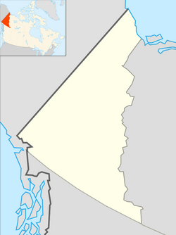
Yukon is the smallest and westernmost of Canada's three territories. It is the second-least populated province or territory in Canada, with a population of 44,412 as of March 2023. Whitehorse, the territorial capital, is the largest settlement in any of the three territories.

<span class="mw-page-title-main">Beaver Creek, Yukon</span> Place in Yukon, Canada

Beaver Creek is a community in Yukon, Canada. Located at kilometre 1870.6 of the Alaska Highway, 1 NM southeast of Beaver Creek Airport and close to the Alcan - Beaver Creek Border Crossing, it is Canada's westernmost community. The community's main employers are a Canada Border Services Agency port, the White River First Nation and a number of tourist lodges.

<span class="mw-page-title-main">Faro, Yukon</span> Town in Yukon, Canada

Faro is a town in central Yukon, Canada, the home of the now abandoned Faro Mine. It was the largest open-pit lead–zinc mine in the world as well as a significant producer of silver and other natural resources. The mine was built by the Ralph M. Parsons Construction Company of the United States with General Enterprises Ltd. of Whitehorse being the main subcontractor. As of 2021, the population is 440, down from its peak population of 1,652 in 1981. Faro was named after the card game of the same name.

<span class="mw-page-title-main">Dawson City</span> Town in Yukon, Canada

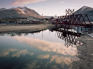
Dawson City, officially the City of Dawson, is a town in the Canadian territory of Yukon. It is inseparably linked to the Klondike Gold Rush (1896–1899). Its population was 1,577 as of the 2021 census, making it the second-largest town in Yukon.

<span class="mw-page-title-main">Carcross</span> Place in Yukon, Canada

Carcross, originally known as Caribou Crossing, is an unincorporated community in Yukon, Canada, on Bennett Lake and Nares Lake. It is home to the Carcross/Tagish First Nation.

<span class="mw-page-title-main">Burwash Landing</span> Place in Yukon, Canada

Burwash Landing is a small community, at historical mile 1093 on the Alaska Highway, in Yukon, Canada along the southern shore of Kluane Lake.

Elsa is a former privately owned mining town in the Canadian territory of Yukon, between the Stewart River valley to the south and the Mackenzie Mountains to the north. It is located at Kilometre 97 of the Silver Trail, approximately 700 kilometres (435 mi) north of Whitehorse and 600 km (373 mi) east of the Alaskan border.

<span class="mw-page-title-main">Carmacks, Yukon</span> Village in Yukon, Canada

Carmacks is a village in Yukon, Canada, on the Yukon River along the Klondike Highway, and at the west end of the Robert Campbell Highway from Watson Lake. The population is 588, an increase from the Census of 2016. It is the home of the Little Salmon/Carmacks First Nation, a Northern Tutchone-speaking people.

<span class="mw-page-title-main">Watson Lake, Yukon</span> Town in Yukon, Canada

Watson Lake is a town in Yukon, Canada, located at mile 635 on the Alaska Highway close to the British Columbia border. It has a population of 790 in 2016. The town is named for Frank Watson, an American-born trapper and prospector, who settled in the area at the end of the 19th century.

The First Nation of Na-Cho Nyäk Dun is a First Nation band government in Yukon, Canada. Its main population centre is in Mayo, Yukon, but many of its members live across Canada and the United States. Members of the First Nation of Na-Cho Nyak Dun claim Gwich'in ancestry, located in north, and Dene ancestry, located in the east, along with their Northern Tutchone ancestry. The Na-cho Nyak Dun are the northernmost representatives of the Northern Tutchone language and culture.

<span class="mw-page-title-main">Mayo, Yukon</span> Village in Yukon, Canada

Mayo is a village in Yukon, Canada, along the Silver Trail and the Stewart River. It had a population of 200 in 2016. The Yukon Bureau of Statistics estimated a population of 496 in 2019. It is also the home of the First Nation of Na-Cho Nyäk Dun, whose primary language is Northern Tutchone. Na-Cho Nyäk Dun translates into "big river people."

<span class="mw-page-title-main">Ross River, Yukon</span>

Ross River is an unincorporated community in Yukon, Canada. It lies at the junction of the Ross River and the Pelly River, along the Canol Road, not far from the Campbell Highway. Primary access to the Campbell Highway is via a nine-mile access road. Formerly it was accessed along a six-mile Canol Road section that is no longer maintained. It is serviced by Ross River Airport, used mainly for charter and scheduled flights to and from Whitehorse and Watson Lake.

Pelly Crossing is a community in Yukon, Canada. It lies where the Klondike Highway crosses the Pelly River.

<span class="mw-page-title-main">Tagish, Yukon</span> Place in Yukon, Canada

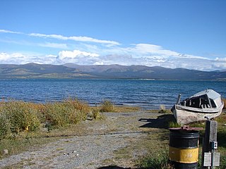
Tagish is an unincorporated community in Yukon, Canada. It is 30 kilometres (19 mi) east of Carcross, Yukon, on the Tagish Road at the northern end of Tagish Lake. The greater Tagish area also includes the Tagish Estates, Tagish Beach and Taku subdivisions, the latter two developed for cottages but now serving for many year-round homes. Tagish Beach and Taku have their own community hall. The Tagish Road was built in 1942 as part of an oil pipeline project, and the community sprouted around a bridge built over the narrow water between Tagish Lake and Marsh Lake.

<span class="mw-page-title-main">Destruction Bay</span> Place in Yukon, Canada

Destruction Bay is a small community on the Alaska Highway in Canada's Yukon on Kluane Lake.

<span class="mw-page-title-main">Stewart Crossing</span> Settlement in Yukon, Canada

Stewart Crossing is a settlement in Yukon, Canada located on the Stewart River. It is about 179 km east of Dawson City on the Klondike Highway, near the junction with the Silver Trail, from which it is about 53 km (33 mi) southwest of Mayo. A Yukon government highway maintenance camp and a highway lodge are the most prominent facilities at Stewart Crossing. The settlement is named for where the Klondike Highway, crossed the Stewart River by means of a ferry from 1950 until completion of a bridge in the mid-1950s.

Two Mile Village is an Indian settlement in southeast Yukon, Canada. It is located on the Robert Campbell Highway, approximately 12 km (7.5 mi) northwest of Watson Lake. The settlement is recognized as a census subdivision by Statistics Canada.

<span class="mw-page-title-main">Unorganized Yukon</span> Unorganized area in Yukon, Canada

Unorganized Yukon, or Yukon, Unorganized, is the unorganized area covering the majority of Yukon, Canada. It represents 98% of Yukon's 474,712.64 km2 (183,287.57 sq mi) land mass, and is recognized as a census subdivision by Statistics Canada.

Mayo was an electoral district which returned an MLA to the Legislative Assembly of the Yukon Territory in Canada. It was created in 1928, at a time when it was one of three districts who elected advisors to the Yukon Territorial Council. The more contemporary, final iteration of the riding was created from an amalgamation of the riding with part of the riding of Klondike. It was abolished in 1992 when it was amalgamated with the riding of Tatchun to form the riding of Mayo-Tatchun.

References

  1. 1 2 3 "Faded Yukon Gold Rush Town, Population 20, Mines Its Weirdness". New York Times . October 15, 2017.
  2. "1986 Census: Population - Census Divisions and Census Subdivisions" (PDF). Statistics Canada. September 1987. Retrieved January 30, 2022.
  3. "91 Census: Census Divisions and Census Subdivisions - Population and Dwelling Counts" (PDF). Statistics Canada. April 1992. Retrieved January 30, 2022.
  4. "96 Census: A National Overview - Population and Dwelling Counts" (PDF). Statistics Canada. April 1997. Retrieved January 30, 2022.
  5. "Population and Dwelling Counts, for Canada, Provinces and Territories, and Census Subdivisions (Municipalities), 2001 and 1996 Censuses - 100% Data (Yukon Territory)". Statistics Canada. August 15, 2012. Retrieved January 30, 2022.
  6. "Population and dwelling counts, for Canada, provinces and territories, and census subdivisions (municipalities), 2006 and 2001 censuses - 100% data (Yukon Territory)". Statistics Canada. August 20, 2021. Retrieved January 30, 2022.
  7. "Population and dwelling counts, for Canada, provinces and territories, and census subdivisions (municipalities), 2011 and 2006 censuses (Yukon)". Statistics Canada. July 25, 2021. Retrieved January 30, 2022.
  8. "Population and dwelling counts, for Canada, provinces and territories, and census subdivisions (municipalities), 2016 and 2011 censuses – 100% data (Yukon)". Statistics Canada. February 8, 2017. Retrieved January 30, 2022.
  9. 1 2 "Population and dwelling counts: Canada, provinces and territories, and census subdivisions (municipalities), Yukon". Statistics Canada. February 9, 2022. Retrieved February 18, 2022.