Cain Township, Fountain County, Indiana

Last updated

Cain Township
Map highlighting Cain Township, Fountain County, Indiana.svg
Coordinates: 40°04′59″N87°09′06″W / 40.08306°N 87.15167°W / 40.08306; -87.15167
Country United States
State Indiana
County Fountain
Government
  Type Indiana township
Area
  Total39.96 sq mi (103.5 km2)
  Land39.93 sq mi (103.4 km2)
  Water0.03 sq mi (0.08 km2)
Elevation
[1]
728 ft (222 m)
Population
 (2020)
  Total1,112
  Density28/sq mi (11/km2)
FIPS code 18-09748
GNIS feature ID453152

Cain Township is one of eleven townships in Fountain County, Indiana. As of the 2020 census, its population was 1,112 and it contained 478 housing units. [2]

Contents

Historical population
CensusPop.Note
1890 1,509
1900 1,5371.9%
1910 1,403−8.7%
1920 1,359−3.1%
1930 1,179−13.2%
1940 1,1830.3%
1950 1,133−4.2%
1960 1,053−7.1%
1970 1,023−2.8%
1980 1,24221.4%
1990 1,160−6.6%
2000 1,090−6.0%
2010 1,1424.8%
2020 1,112−2.6%
Source: US Decennial Census [3]

History

Cain Township was one of the first townships to be established in the county; it was established on July 24, 1826. [4] At that time, much of the land was forested, but 100 years later most of the land was used for agriculture. There were also several grain and lumber mills along Coal Creek, but these also were gone by the early 20th century. The town of Hillsboro was laid out in the 1830s and still exists; the town of Rynear was established in the far northwest corner of the township, but was gone by the early 1900s. The township's population was 1,763 in 1880, 1,537 in 1900, and 1,403 in 1910. [5]

Geography

According to the 2010 census, the township has a total area of 39.96 square miles (103.5 km2), of which 39.93 square miles (103.4 km2) (or 99.92%) is land and 0.03 square miles (0.078 km2) (or 0.08%) is water. [6] There is a single settlement in the township: the town of Hillsboro, which has a population of about 500 (about half the township's total population). This lies at the intersection of the east–west U.S. Route 136 [7] and the north–south Indiana State Road 341, [8] in the northern part of the township. Interstate 74 passes from east to west less than 1 mile (1.6 km) north of Hillsboro. [9] Indiana State Road 32 runs along a portion of the southern border of the township. [10]

Map of Cain Township Map of Cain Township, Fountain County, Indiana.svg
Map of Cain Township

Cemeteries

The township contains three cemeteries. Rose Hill to the north and Spring Hill lie to the south of Hillsboro, [11] [12] while Scotts Prairie is in the far southwest corner of the township. [13]

Related Research Articles

<span class="mw-page-title-main">Fountain County, Indiana</span> County in Indiana, United States

Fountain County lies in the western part of the U.S. state of Indiana on the east side of the Wabash River. The county was officially established in 1826 and was the 53rd in Indiana. The county seat is Covington.

<span class="mw-page-title-main">Adams Township, Warren County, Indiana</span> Township in Indiana, United States

Adams Township is one of twelve townships in Warren County, Indiana. According to the 2020 census, its population was 535 and it contained 243 housing units.

<span class="mw-page-title-main">Kent Township, Warren County, Indiana</span> Township in Indiana, United States

Kent Township is one of twelve townships in Warren County, Indiana, United States. According to the 2020 census, its population was 452 and it contained 189 housing units.

<span class="mw-page-title-main">Liberty Township, Warren County, Indiana</span> Township in Indiana, United States

Liberty Township is one of twelve townships in Warren County, Indiana, United States. According to the 2020 census, its population was 861 and it contained 370 housing units.

<span class="mw-page-title-main">Medina Township, Warren County, Indiana</span> Township in Indiana, United States

Medina Township is one of twelve townships in Warren County, Indiana, United States. According to the 2020 census, its population was 510 and it contained 200 housing units.

<span class="mw-page-title-main">Mound Township, Warren County, Indiana</span> Township in Indiana, United States

Mound Township is one of twelve townships in Warren County, Indiana, United States. According to the 2020 census, its population was 407 and it contained 199 housing units.

<span class="mw-page-title-main">Pike Township, Warren County, Indiana</span> Township in Indiana, United States

Pike Township is one of twelve townships in Warren County, Indiana, United States. According to the 2020 census, its population was 1,167 and it contained 515 housing units.

<span class="mw-page-title-main">Pine Township, Warren County, Indiana</span> Township in Indiana, United States

Pine Township is one of twelve townships in Warren County, Indiana, United States. According to the 2020 census, its population was 499 and it contained 223 housing units.

<span class="mw-page-title-main">Prairie Township, Warren County, Indiana</span> Township in Indiana, United States

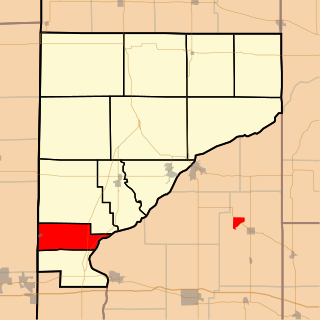
Prairie Township is one of twelve townships in Warren County, Indiana, United States. According to the 2020 census, its population was 230 and it contained 110 housing units; the population density is the lowest of any township in the county, at 6.1 inhabitants per square mile (2.4/km2).

<span class="mw-page-title-main">Steuben Township, Warren County, Indiana</span> Township in Indiana, United States

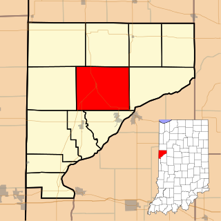
Steuben Township is one of twelve townships in Warren County, Indiana, United States. It was established in 1834. According to the 2020 census, its population was 493 and it contained 191 housing units. It contains no incorporated towns and is largely agricultural.

<span class="mw-page-title-main">Warren Township, Warren County, Indiana</span> Township in Indiana, United States

Warren Township is one of twelve townships in Warren County, Indiana, United States. According to the 2010 census, its population was 806 and it contained 324 housing units.

<span class="mw-page-title-main">Washington Township, Warren County, Indiana</span> Township in Indiana, United States

Washington Township is one of twelve townships in Warren County, Indiana, United States. It is the most populous township in the county; according to the 2020 census, its population was 2,349, with 1,950 of those living in Williamsport, and it contained 1,001 housing units. It has the highest population density of the Warren County townships at about 120 inhabitants per square mile (46/km2).

<span class="mw-page-title-main">Davis Township, Fountain County, Indiana</span> Township in Indiana, United States

Davis Township is one of eleven townships in Fountain County, Indiana, United States. As of the 2020 census, its population was 564 and it contained 285 housing units.

<span class="mw-page-title-main">Fulton Township, Fountain County, Indiana</span> Township in Indiana, United States

Fulton Township is one of eleven townships in Fountain County, Indiana, United States. As of the 2020 census, its population was 606.

<span class="mw-page-title-main">Jackson Township, Fountain County, Indiana</span> Township in Indiana, United States

Jackson Township is one of eleven townships in Fountain County, Indiana, United States. As of the 2020 census, its population was 588 and it contained 308 housing units.

<span class="mw-page-title-main">Logan Township, Fountain County, Indiana</span> Township in Indiana, United States

Logan Township is one of eleven townships in Fountain County, Indiana, United States. As of the 2020 census, its population was 3,377 and it contained 1,641 housing units.

<span class="mw-page-title-main">Millcreek Township, Fountain County, Indiana</span> Township in Indiana, United States

Millcreek Township is one of eleven townships in Fountain County, Indiana, United States. As of the 2020 census, its population was 1,385 and it contained 791 housing units.

<span class="mw-page-title-main">Richland Township, Fountain County, Indiana</span> Township in Indiana, United States

Richland Township is one of eleven townships in Fountain County, Indiana, United States. As of the 2020 census, its population was 842 and it contained 384 housing units.

<span class="mw-page-title-main">Shawnee Township, Fountain County, Indiana</span> Township in Indiana, United States

Shawnee Township is one of eleven townships in Fountain County, Indiana, United States. As of the 2020 census, its population was 662 and it contained 284 housing units.

<span class="mw-page-title-main">Troy Township, Fountain County, Indiana</span> Township in Indiana, United States

Troy Township is one of eleven townships in Fountain County, Indiana. As of the 2020 census, its population was 3,735 and it contained 1,674 housing units.

References

  1. "US Board on Geographic Names". United States Geological Survey. October 25, 2007. Retrieved January 31, 2008.
  2. "Explore Census Data". data.census.gov. Retrieved April 14, 2024.
  3. "Township Census Counts: STATS Indiana".
  4. Clifton 1913, p. 59.
  5. Clifton 1913, pp. 188–189.
  6. "Population, Housing Units, Area, and Density: 2010 - County -- County Subdivision and Place -- 2010 Census Summary File 1". United States Census. Archived from the original on February 12, 2020. Retrieved May 10, 2013.
  7. "U.S. Route 136". Highway Explorer. Archived from the original on July 11, 2011. Retrieved September 21, 2010.
  8. "State Road 341". Highway Explorer. Archived from the original on July 11, 2011. Retrieved September 21, 2010.
  9. "Interstate 74". Highway Explorer. Archived from the original on July 11, 2011. Retrieved September 21, 2010.
  10. "State Road 32". Highway Explorer. Archived from the original on July 11, 2011. Retrieved September 21, 2010.
  11. "Rose Hill Cemetery". Geographic Names Information System . United States Geological Survey, United States Department of the Interior . Retrieved September 5, 2011.
  12. "Spring Hill Cemetery". Geographic Names Information System . United States Geological Survey, United States Department of the Interior . Retrieved September 5, 2011.
  13. "Scotts Prairie Cemetery". Geographic Names Information System . United States Geological Survey, United States Department of the Interior . Retrieved September 5, 2011.

Bibliography