Mellott, Indiana

Last updated

Mellott
Fountain County Indiana Incorporated and Unincorporated areas Mellott Highlighted 1848294.svg
Location of Mellott in Fountain County, Indiana.
Location map of Fountain County, Indiana.svg
Red pog.svg
Mellott
Mellott's location in Fountain County
Coordinates: 40°09′51″N87°08′56″W / 40.16417°N 87.14889°W / 40.16417; -87.14889
Country United States
State Indiana
County Fountain
Township Richland
Area
[1]
  Total0.34 sq mi (0.89 km2)
  Land0.34 sq mi (0.89 km2)
  Water0.00 sq mi (0.00 km2)
Elevation
[2]
702 ft (214 m)
Population
 (2020)
  Total174
  Density508.77/sq mi (196.34/km2)
Time zone UTC-5 (Eastern (EST))
  Summer (DST) UTC-4 (EDT)
ZIP code
47958
Area code 765
FIPS code 18-48294 [3]
GNIS feature ID2396749 [2]

Mellott is a town in Richland Township, Fountain County, Indiana, United States. The population was 197 at the 2010 census.

Contents

History

The Mellott post office was established in 1882. [4] It was named in honor of John Mellott, the first postmaster. [5]

Geography

According to the 2010 census, Mellott has a total area of 0.17 square miles (0.44 km2), all land. [6]

Demographics

Historical population
CensusPop.Note
1910 372
1920 340−8.6%
1930 312−8.2%
1940 302−3.2%
1950 266−11.9%
1960 31217.3%
1970 3254.2%
1980 294−9.5%
1990 222−24.5%
2000 207−6.8%
2010 197−4.8%
2020 174−11.7%
U.S. Decennial Census [7]

2010 census

As of the census [8] of 2010, there were 197 people, 88 households, and 55 families living in the town. The population density was 1,158.8 inhabitants per square mile (447.4/km2). There were 102 housing units at an average density of 600.0 per square mile (231.7/km2). The racial makeup of the town was 99.0% White and 1.0% from two or more races. Hispanic or Latino of any race were 2.5% of the population.

There were 88 households, of which 27.3% had children under the age of 18 living with them, 45.5% were married couples living together, 14.8% had a female householder with no husband present, 2.3% had a male householder with no wife present, and 37.5% were non-families. 34.1% of all households were made up of individuals, and 19.3% had someone living alone who was 65 years of age or older. The average household size was 2.24 and the average family size was 2.85.

The median age in the town was 42.8 years. 22.8% of residents were under the age of 18; 7.7% were between the ages of 18 and 24; 21.4% were from 25 to 44; 23.9% were from 45 to 64; and 24.4% were 65 years of age or older. The gender makeup of the town was 45.7% male and 54.3% female.

2000 census

As of the census [3] of 2000, there were 207 people, 87 households, and 60 families living in the town. The population density was 1,317.8 inhabitants per square mile (508.8/km2). There were 94 housing units at an average density of 598.4 per square mile (231.0/km2). The racial makeup of the town was 99.52% White and 0.48% Native American. Hispanic or Latino of any race were 1.45% of the population.

There were 87 households, out of which 29.9% had children under the age of 18 living with them, 50.6% were married couples living together, 10.3% had a female householder with no husband present, and 29.9% were non-families. 29.9% of all households were made up of individuals, and 19.5% had someone living alone who was 65 years of age or older. The average household size was 2.38 and the average family size was 2.89.

In the town, the population was spread out, with 28.0% under the age of 18, 3.4% from 18 to 24, 29.5% from 25 to 44, 19.8% from 45 to 64, and 19.3% who were 65 years of age or older. The median age was 37 years. For every 100 females, there were 89.9 males. For every 100 females age 18 and over, there were 77.4 males.

The median income for a household in the town was $29,375, and the median income for a family was $37,500. Males had a median income of $33,750 versus $25,000 for females. The per capita income for the town was $19,694. About 5.9% of families and 11.1% of the population were below the poverty line, including 21.9% of those under the age of eighteen and 15.2% of those 65 or over.

Related Research Articles

<span class="mw-page-title-main">Ashley, Indiana</span> Town in Indiana, United States

Ashley is a town in Indiana located on the border of Smithfield Township, DeKalb County and Steuben Township, Steuben County. The population was 983 at the 2010 census.

<span class="mw-page-title-main">Fillmore, Indiana</span> Town in Indiana, United States

Fillmore is a town in Marion Township, Putnam County, in the U.S. state of Indiana. The population was 532 at the 2020 census.

<span class="mw-page-title-main">Crystal, Maine</span> Town in the state of Maine, United States

Crystal is a town in Aroostook County, Maine, United States. The population was 248 at the 2020 census.

<span class="mw-page-title-main">Haynesville, Maine</span> Town in the state of Maine, United States

Haynesville is a town in Aroostook County, Maine, United States. The population was 97 at the 2020 census.

<span class="mw-page-title-main">Hersey, Maine</span> Town in the state of Maine, United States

Hersey is a town in Aroostook County, Maine, United States. The population was 73 at the 2020 census.

<span class="mw-page-title-main">New Canada, Maine</span> Town in the state of Maine, United States

New Canada is a town in Aroostook County, Maine, United States. The population was 310 at the 2020 census.

<span class="mw-page-title-main">Perham, Maine</span> Town in the state of Maine, United States

Perham is a town in Aroostook County, Maine, United States. The population was 371 at the 2020 census. The town was named after Maine's 33rd governor, Sidney Perham.

<span class="mw-page-title-main">Sherman, Maine</span> Town in the state of Maine, United States

Sherman is a town in Aroostook County, Maine, United States. The population was 815 at the 2020 census.

<span class="mw-page-title-main">West Gardiner, Maine</span> Town in the state of Maine, United States

West Gardiner is a town in Kennebec County, Maine, United States. The population was 3,671 at the 2020 census. West Gardiner is included in the Augusta, Maine micropolitan New England City and Town Area.

Lowell is a town in Penobscot County, Maine, United States. The population was 368 at the 2020 census.

Detroit is a town in Somerset County, Maine, United States. The population was 885 at the 2020 census.

Ripley is a town in Somerset County, Maine, United States. The community was named after Brigadier General Eleazer Wheelock Ripley of the War of 1812. The population was 484 at the 2020 census.

Meddybemps is a town in Washington County, Maine, United States. The population was 139 at the 2020 census.

Talmadge is a town in Washington County, Maine, United States. The town was named after landowner Benjamin Tallmadge. The population was 70 at the 2020 census.

<span class="mw-page-title-main">Kelliher, Minnesota</span> Town in Minnesota, United States

Kelliher is a city in Beltrami County, Minnesota, United States. The population was 258 at the 2020 census. Minnesota State Highway 72 is the primary route through Kelliher.

<span class="mw-page-title-main">Urbank, Minnesota</span> City in Minnesota, United States

Urbank is a city in Otter Tail County, Minnesota, United States. The population was 52 at the 2020 census.

<span class="mw-page-title-main">Prairie Rose, North Dakota</span> City in North Dakota, United States

Prairie Rose is a city in Cass County, North Dakota, United States. The population was 56 at the 2020 census. The city is an enclave suburb of Fargo. Prairie Rose was founded in 1975 and it was incorporated in 1978. There are 21 homes in the city.

<span class="mw-page-title-main">Addyston, Ohio</span> Village in Ohio, United States

Addyston is a village in Miami Township, Hamilton County, Ohio, United States. Located along the Ohio River, it is a western suburb of the neighboring city of Cincinnati. The population was 927 at the 2020 census.

<span class="mw-page-title-main">Auburn, West Virginia</span> Town in West Virginia, United States

Auburn is a town in Ritchie County, West Virginia, United States. The population was 80 at the 2020 census.

<span class="mw-page-title-main">St. Albans, Maine</span> Town in the state of Maine, United States

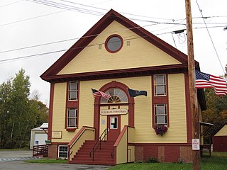
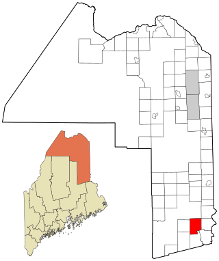
St. Albans is a town in Somerset County, Maine, United States. The population was 2,045 at the 2020 census.

References

  1. "2020 U.S. Gazetteer Files". United States Census Bureau. Retrieved March 16, 2022.
  2. 1 2 U.S. Geological Survey Geographic Names Information System: Mellott, Indiana
  3. 1 2 "U.S. Census website". United States Census Bureau . Retrieved January 31, 2008.
  4. "Fountain County". Jim Forte Postal History. Retrieved September 6, 2014.
  5. Baker, Ronald L. (October 1995). From Needmore to Prosperity: Hoosier Place Names in Folklore and History . Indiana University Press. p.  215. ISBN   978-0-253-32866-3. ...with John B. Mellott as postmaster...
  6. "G001 - Geographic Identifiers - 2010 Census Summary File 1". United States Census Bureau. Archived from the original on February 13, 2020. Retrieved July 17, 2015.
  7. "Census of Population and Housing". Census.gov. Retrieved June 4, 2015.
  8. "U.S. Census website". United States Census Bureau . Retrieved December 11, 2012.