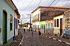
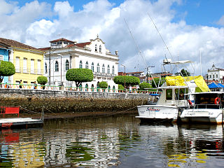
Santo Amaro, also known as Santo Amaro da Purificação, is a municipality in the state of Bahia in Brazil. The population is 60,131 in an area of 492.9 square kilometres (190.3 sq mi). It is located in the metropolitan area of Salvador. Santo Amaro is located approximately 73 kilometres (45 mi) from the city of Salvador. Santo Amaro was home to numerous indigenous peoples until the arrival of the Portuguese, who developed the region for sugarcane production. Santo Amaro is now noted for its numerous historic structures. The city is also a center of Candomblé, having more than 60 terreiros, or temples of the religion.

Santa Cruz das Flores is a municipality situated in the north half of the island of Flores, in the Portuguese archipelago of the Azores. Situated in the sparsely populated Western Group, the population in 2021 was 2,020 inhabitants in an area that covers approximately 70.91 square kilometres (27.38 sq mi), bordering the southern municipality of Lajes das Flores.

Ribeira Grande is a municipality in the northern part of the island of São Miguel in the Portuguese Azores. The population in 2011 was 32,112, in an area of 180.15 km2. The municipal seat is located in the civil parish of Matriz, with a population of about 4000 inhabitants, part of the urbanized core of what is commonly referred to as the city of Ribeira Grande.

Alandroal is a municipality in the Portuguese district of Évora located on the eastern frontier with Spain along the right margin of the Guadiana River in the Central Alentejo region. It is located 341 metres (1,119 ft) above sea level, northeast of Évora and southeast of Estremoz. The population in 2011 was 5,843, in an area of 542.68 km².

São Cristóvão is a Brazilian municipality in the Northeastern state of Sergipe. Founded at the mouth of the Vaza-Barris River on January 1, 1590, the municipality is the fourth oldest settlement in Brazil. São Cristóvão is noted for its historic city square, São Francisco Square, and numerous early colonial-period buildings. The 3 hectares site was designated a UNESCO World Heritage Site in 2010.

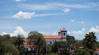
Cachoeira is an inland municipality of Bahia, Brazil, on the Paraguaçu River. The town exports sugar, cotton, and tobacco and is a thriving commercial and industrial centre.

Lagoa is a city and municipality in the district of Faro, in the Portuguese region of Algarve. The population of the municipality in 2011 was 22,975, in an area of 88.25 km². Its urban population, in the city of Lagoa proper, is 6,100 inhabitants. An important travel destination, its coast has won numerous accolades. Marinha Beach was considered by the Michelin Guide as one of the 10 most beautiful beaches in Europe and as one of the 100 most beautiful beaches in the world.
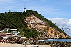
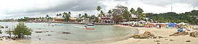
Morro de São Paulo is one of 5 villages of the island of Tinharé in the municipality of Cairu, located in the state of Bahia, Brazil. The main beaches of the Morro de São Paulo are located on east side of the island. They are: Primeira Praia, Segunda Praia, Terceira Praia, Quarta Praia and Quinta Praia. The settlement was home to a large Tumpinamba population prior to the arrival of the Portuguese. A Portuguese colony was established as early as 1535. The settlement is a site of large-scale tourism, and has three registered historic sites.
Sabará is a Brazilian municipality located in the state of Minas Gerais. The city belongs to the Belo Horizonte metropolitan region and to the associated microregion.

Colares is a civil parish along the coast of the municipality of Sintra. The population in 2011 was 7,628, in an area of 33.37 square kilometres (12.88 sq mi).
Valença is a Brazilian city in the state of Bahia and has an estimated population of 97,233. It is visited by tourists because it is the main access to the island of Ilha de Tinharé, famous for the town of Morro de São Paulo.
Braga is a civil parish in the municipality of Braga, Portugal. It was formed in 2013 by the merger of the former parishes Maximinos, Sé and Cividade. The population in 2011 was 14,572, in an area of 2.57 km2.

Jacobina is a city in the Centro Norte Baiano mesoregion of Bahia. It was founded July 28, 1722 and the population is 82,590. The town is surrounded by mountains, hills, lakes, rivers, springs, and waterfalls. Located in the northwest region of Bahia, in the extreme north of the Chapada Diamantina, Jacobina is 330 kilometers from Salvador and is also known as 'City of Gold', a legacy of the gold mines which attracted the pioneers from São Paulo in the early seventeenth century.

São Francisco do Conde is a municipality in the state of Bahia in the North-East region of Brazil. São Francisco do Conde covers 262.856 km2 (101.489 sq mi), and has a population of 40,245 with a population density of 150 inhabitants per square kilometer. It is located 67 kilometres (42 mi) from the state capital of Salvador. According to the Brazilian Institute of Geography and Statistics São Francisco do Conde has the highest concentration of Brazilians of African descent (90%) in Bahia.

Jaguaripe is a municipality in the state of Bahia in the North-East region of Brazil. It covers 863.424 km2 (333.370 sq mi), and has a population of 18,981 with a population density of 18.32 inhabitants per square kilometer. Jaguaripe is located 130 km (81 mi) from the state capital of Bahia, Salvador. Jaguaripe shares a border with the municipalities of Aratuípe, Nazaré, Maragogipe, Laje, São Miguel das Matas, and Santo Antônio de Jesus. It was the first municipality created outside of Salvador, dating to 1693.

Nazaré, also known as Nazaré das Farinhas, is a municipality in the state of Bahia in the North-East region of Brazil. The municipality has a population of 28,594 with a population density of 107 inhabitants per square kilometer. It is located 110 km (68 mi) from the state capital of Bahia, Salvador. Nazaré is within the Bahian Recôncavo, an interior region of the state of Bahia. It borders the municipalities of Muniz Ferreira, Aratuípe, Jaguaripe, São Felipe, and Maragogipe. The Jaguaripe River crosses through the middle of the town. It is sits on the intersection of two Bahian state highways, BA-001 and BA-046.
Nossa Senhora do Bispo is a former civil parish in the municipality of Montemor-o-Novo, Portugal. In 2013, the parish merged into the new parish Nossa Senhora da Vila, Nossa Senhora do Bispo e Silveiras. It has an area of 121.83 km², and a population of approximately 5411 inhabitants in 2001. It contains the localities Fazendas do Cortiço, Ferro da Agulha and São Geraldo.

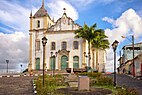
The Church of the Third Order of the Blessed Virgin Mary of Our Lady of the Conception of the Mulatto Brothers is an 18th-century Roman Catholic church and former convent in Salvador, Bahia, Brazil. The church was constructed in a neighborhood formerly occupied by mixed-race and Afro-Brazilian artisans. The exterior of the church has an elaborate roccoco pediment and towers; the interior of the church has a Baroque-style ceiling painting in the nave and neoclassical side altars and chancel. The name of the church, boqueirão, refers to a large slope and trench constructed between the high city and low city of Salvador; it served as a defense of the city against foreign invasion. It was listed as a historic structure by the National Historic and Artistic Heritage Institute in 1951.

The Fonte Grande of Morro de São Paulo is a Baroque-style fountain on Tinharé Island, Cairu, Bahia, Brazil. It dates to 1746 and was constructed by André de Melo e Castro, viceroy of Brazil, to supply water to a prison, soldiers, and residents. The fountain is located to the southeast of the settlement of Morro de São Paulo, and was the most advanced water supply system in colonial Brazil. It was listed as a historic structure by the National Institute of Historic and Artistic Heritage in 1943.