Camanche Reservoir

Last updated

Camanche Reservoir
Camanche Reservoir From A320.jpg
Camanche Reservoir as viewed from a passing airliner
Relief map of California.png
Red pog.svg
Camanche Reservoir
Location Amador, Calaveras and San Joaquin counties [1]
Coordinates 38°13′25″N121°00′00″W / 38.22361°N 121.00000°W / 38.22361; -121.00000 [1]
Type reservoir
Primary outflows Mokelumne River [2]
Catchment area 619 square miles (1,600 km2) [2]
Basin  countriesUnited States
Max. length5 miles (8.0 km)
Max. width3 miles (4.8 km)
Surface area7,700 acres (3,100 ha) [2]
Max. depth150 feet (46 m) [3]
Water volume417,120 acre-feet (514,510,000 m3) [2]
Shore length153 miles (85 km) [4]
Surface elevation135 ft (41 m) [1]
1 Shore length is not a well-defined measure.

Camanche Reservoir is an artificial lake in the San Joaquin Valley in California in the United States, at the juncture of Amador, Calaveras, and San Joaquin counties. Its waters are impounded by Camanche Dam, which was completed in 1963. Camanche Reservoir is a source of water for industrial and municipal purposes and also provides flood control.

Contents

The lake was named after the former town of Camanche that now lies beneath its waters. The lake has also been called Camanche Lake [1] and Lake Camanche. [5] Camanche Reservoir has recreation areas throughout the lake, which are mainly located on the North and South shores.

North Shore

Camanche Reservoir North Shore is located in Amador County. It contains a population of approximately 1,000 people. The North Shore hosts some of the recreation features of Camanche Reservoir, including close to 800 campsites. The North Shore also allows RV camping as well as tent camping. There is a North Shore Marina Store located here including a small café.

South Shore

Camanche Reservoir South Shore also hosts a large portion of Lake Camanche's recreation features and amenities. The South Shore includes a store located in the middle of the recreation area. It also contains the two RV parks which offer full hook-ups, (water, electric, and sewer) and an amphitheater where numerous events are held.

Hydrology

The lake is fed by the headwaters of the Mokelumne River, [2] including tributaries such as Rabbit Creek and Camanche Creek. The Camanche Reservoir is fed primarily from the Mokelumne River. The water entering Camanche Reservoir is influenced by the amount of water released from the Pardee Dam. Camanche reservoir typically fills to capacity prior to summer months. This occurs from the melting of snowpack during the months of May–July (meltflow season) which increase the amount of water flowing through the Mokelumne River. During summer months, Camanche Reservoir releases water continuously. [6] This allows for constant reliable downstream irrigation.

The recent drought in California has impacted the water levels in the Camanche Reservoir. The reservoir has an ability to hold 417,120 acre feet (AF) of water at maximum capacity. During the recent drought experienced in California, the water levels have been declining from the period of 2011 to 2015. This is due to the decreased amount of precipitation and snowpack melt water received in the Mokelumne River. The drought caused the water levels to reach low levels in late 2015. The month showing the lowest water level was August, 2015 with the water volume in the reservoir decreasing to 81,940 AF, approximately 19.6% of the reservoirs maximum capacity. [7] Water levels have been increasing through the winter months of 2015-2016 reaching 240,340 AF during April, 2016. [7]

Ground water sources surrounding the reservoir typically flow in similar patterns to the surface streams. Due to the geology of the area the ground water sources typically do not exceed depths of 300 feet and rarely produce water near 600 feet.

Mokelumne River Hatchery

With the creation of several reservoirs along the Mokelumne River many populations of fish species were impacted. Because of this the Mokelumne River Hatchery was created down river of the Camanche Reservoir. This hatchery was built in 1963 to help recover the fish spawning levels that traditionally existed in the river. The fish hatchery was remodeled and updated in 2002. This remodeling involved enlarging the rearing space located at the site. This was done to allow for the promotion of fish health and to increase the survival rates of the fish raised at the site. These improvements to the facility have allowed for the returning salmon to increase by 3,028 during the period of 1998-2003. [8] There are two main species that are raised at the Mokelumne River Hatchery. These species are the Chinook salmon and the Steelhead trout.

Biodiversity

Camanche reservoir contains a variety of fish species which attracts many people who enjoy fishing. The reservoir has species of bass, trout, crappie, and catfish among other species.

There are also a variety of bird species located near the reservoir. Birdwatching is a part of the recreation at Camanche Reservoir and self-guided bird walks are allowed as well as bird watching tours. Bird species include various duck species, Great Egrets, multiple woodpecker species, Turkey Vultures, and multiple sparrow species. There is also a large amount of songbird species that live in the surrounding area near the reservoir. [9]

There are also a variety of mammalian species located on or near the reservoir. Near Camanche Reservoir small mammal species such as squirrels and rodents are abundant and can be seen from various recreation areas. Deer are also known to frequent the area near Camanche Reservoir. Predators such as bobcats exists near Lake Camanche but are rarely spotted.

There is a variety of plant species located in the surrounding area of Camanche Reservoir. The vegetation is similar to what is found in Savannah woodland. More specifically it is characterized as a California oak woodland community. These plant communities thrive in environments with hot dry periods and periodic fires. The fires have been suppressed in present times due to human development and populations in the surrounding area. The area is dominated by oak species, like the valley oak and blue oak. These species tend to grow in a spread fashion opposed to clumping together. There are a variety of plant species that grow in the understory of the oak trees. These plant species include various grasses, herbs, and shrubs. Many of these plants are native to California but there are many introduced grasses as well.

Climate

Camanche Reservoir is located in what is known as a Mediterranean Climate. Characteristics of the climate near Camanche Reservoir include relatively low annual rainfall, warm to hot summers, and cool mild winters. The majority of the annual precipitation is in the form of rain, and falls mainly during the winter months. The area has very high sun intensities during the summer months and relatively low humidity. [10]

Geology

The geology near Camanche Reservoir varies between different soil types and slope gradients. [11] The soil ranges from sandy loams, loams, and rock lands. Loam soil types are typically sandy in texture and composition and also contain portions of silt and clay. They are typically made up of 40 percent sand, 40 percent silt, and 20 percent clay. Sandy loams contain a higher concentration of sand compared to other loams. The slope varies from a 2% gradient up to a 45% gradient. Due to the upland areas near the reservoir, the rock land soil type is dominant. These soil types interact with the ground water located near the reservoir by influencing surface water runoff and ground water recharge. The structural geology of the area has experienced changes in the past due to plate tectonics, influencing the layout and shape of the surrounding land.

History

The communities of Camanche, Lancha Plana, and Poverty Bar were inundated by the creation of this reservoir. The region was originally settled during the gold rush into three separate towns. As the gold rush slowed, these towns began to decrease in population. Settlers from Iowa named the largest remaining town “Camanche” after a town in Iowa. Camanche remained a small town, and was eventually evacuated by the East Bay Municipal Utility District to build the dam and reservoir that exists there today. [12]

Recreation

Recreational uses of the lake include boating, [13] fishing [5] and waterskiing. [14] The California Office of Environmental Health Hazard Assessment released an advisory statement regarding eating fish caught from this reservoir based on the mercury level.

Many shaded day-use and picnic sites can be found throughout the Camanche Recreation Area. These sites are popular for families and groups wanting to spend a day at the lake. Many of these sites offer immediate access to the lake's amenities. Scenic hiking and equestrian trails travel around the north and south shores. Each trail goes along rolling hills and through several oak groves that offer intermittent shade. A trail use permit is required and may be purchased at either gate. Tennis, basketball and volleyball courts are located on both shores as are playgrounds for children.

There are over 500 campsites and 200 RV locations around the reservoir. Many campsites include facilities such as bathrooms, tables, heated showers, laundry facilities and barbeques. These sites are available year-round. Cottage and motel rooms are also available for those who do not want stay in tents. [15] Camanche Reservoir is known for bass and trout fishing and has more than 50,000 pounds of trout stocked in the reservoir each year. State fishing licenses are required for anyone over the age of 16, and there is a five dollar fishing fee. Boat rentals are also available at the reservoir, as well as 8-lane boat launches at each shore. [15] Any boat entering the reservoir is subject to inspection to help prevent the spread of invasive Quagga Muscles. An amphitheater is also located at the reservoir which has various events. Stores are located at each marina for any food needs. There is also the North Shore Café and the South Shore Marina Grill for visitors to purchase food or drinks. Dogs are allowed at the reservoir for a small fee and must remain on leashes throughout the visit.

Day Use Fees
ActivityFee ($)
Fishing Access5.5
Boat Launching17
Car/Boat Fee17
Car12.5
Car (after 3:00PM)10
Motor Bike12.5
Dog5.5
Mini Bus (10-20 passengers)19
Bus (21 or more passengers)36

[15]

Camping Rates
ActivityFee ($)
1 Night28
1 Night (October- April Fri-Sun)16
1 Night (October- April Mon-Thurs)8
1 Week (May–September)150
1 Week (August–April)80
2 Week (May–September)275
2 Week (August–April)160
Second Car per night12
Second Car per week70

[15]

See also

Related Research Articles

<span class="mw-page-title-main">Folsom Lake State Recreation Area</span> Park on the American River in the Sacramento metropolitan area

The Folsom Lake State Recreation Area surrounds Folsom Lake in the foothills of the Sierra Nevada. The majority of it is owned by the U.S. Bureau of Reclamation and is managed by the California Department of Parks and Recreation. It is located near the city of Folsom, California, about 25 miles (40 km) east of Sacramento.

<span class="mw-page-title-main">Salmon River (New York)</span> River in the United States

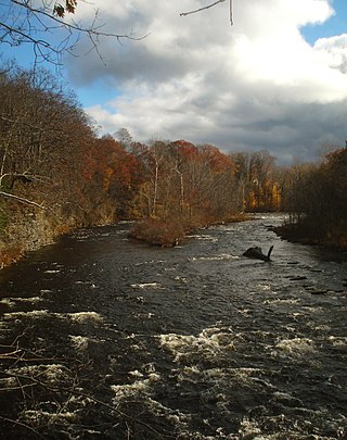
The Salmon River is a small river north of Syracuse in Upstate New York, the United States. It is a popular and economically important sportfishing destination, and the most heavily fished of New York's Lake Ontario tributaries. From its headwaters in the Tug Hill region of New York, it flows 44 miles (71 km) westward through two hydroelectric dams and over the 110-foot (34 m) Salmon River Falls before it empties into eastern Lake Ontario at Port Ontario in Oswego County. The Salmon River watershed drains approximately 280 square miles (730 km2).

<span class="mw-page-title-main">Lake Oroville</span> Reservoir in Butte County, California, U.S.

Lake Oroville is a reservoir formed by the Oroville Dam impounding the Feather River, located in Butte County, northern California. The lake is situated 5 miles (8 km) northeast of the city of Oroville, within the Lake Oroville State Recreation Area, in the western foothills of the Sierra Nevada. Known as the second-largest reservoir in California, Lake Oroville is treated as a keystone facility within the California State Water Project by storing water, providing flood control, recreation, freshwater releases to assist in controlling the salinity intrusion into the Sacramento-San Joaquin Delta and protecting fish and wildlife.

<span class="mw-page-title-main">Mokelumne River</span> River in northern California

The Mokelumne River is a 95-mile (153 km)-long river in northern California in the United States. The river flows west from a rugged portion of the central Sierra Nevada into the Central Valley and ultimately the Sacramento–San Joaquin River Delta, where it empties into the San Joaquin River-Stockton Deepwater Shipping Channel. Together with its main tributary, the Cosumnes River, the Mokelumne drains 2,143 square miles (5,550 km2) in parts of five California counties. Measured to its farthest source at the head of the North Fork, the river stretches for 157 miles (253 km).

<span class="mw-page-title-main">Trinity Lake</span> Reservoir in Trinity County, California

Trinity Lake, previously called Clair Engle Lake, is a reservoir on the Trinity River formed by the Trinity Dam and located in Trinity County, California, United States. The dam was built by the U.S. Bureau of Reclamation. The lake's capacity is 2,447,650 acre⋅ft (3,019.13 GL), making it one of the largest reservoirs in California. The lake's surface is at 2,370 ft (720 m) above MSL. Trinity Lake captures and stores water for the Central Valley Project, which provides the Central Valley with water for irrigation and produces hydroelectric power. This lake is known for its many small arms, glassy inlets, and good water-skiing conditions.

<span class="mw-page-title-main">Lake Diefenbaker</span> Lake in Saskatchewan, Canada

Lake Diefenbaker is a reservoir and bifurcation lake in southern part of the Canadian province of Saskatchewan. It was formed by the construction of Gardiner Dam and the Qu'Appelle River Dam across the South Saskatchewan and Qu'Appelle Rivers respectively. Construction began in 1959 and the lake was filled in 1967. The lake is 225 kilometres (140 mi) long with approximately 800 kilometres (500 mi) of shoreline. It has a maximum depth of 66 metres (217 ft), while the water levels regularly fluctuate 3–9 metres (9–27 feet) each year. The flow of the two rivers is now regulated with a considerable portion of the South Saskatchewan diverted into the Qu'Appelle. Prior to the dams' construction, high water levels in the South Saskatchewan would frequently cause dangerous ice conditions downstream in Saskatoon while the Qu'Appelle would frequently dry up in the summer months.

<span class="mw-page-title-main">Lewis and Clark Lake</span> Man-made lake in Nebraska and South Dakota, United States

Lewis and Clark Lake is a 31,400 acre (130 km²) reservoir located on the border of the U.S. states of Nebraska and South Dakota on the Missouri River. The lake is approximately 25 miles (40 km) in length with over 90 miles (140 km) of shoreline and a maximum water depth of 45 feet (14 m). The lake is impounded by Gavins Point Dam and is managed by the U.S. Army Corps of Engineers, Omaha District.

<span class="mw-page-title-main">Folsom Lake</span> Reservoir on the American River in the Sacramento metropolitan area

Folsom Lake is a reservoir on the American River in the Sierra Nevada foothills of California, United States. Folsom Lake with its surrounding Folsom Lake State Recreation Area is one of the most visited parks in the California park system.

<span class="mw-page-title-main">New Hogan Lake</span> Reservoir in Calaveras County, California

New Hogan Lake is an artificial lake in the foothills of the Sierra Nevada in Calaveras County, California, about 30 miles (48.3 km) northeast of Stockton. It is formed by New Hogan Dam on the Calaveras River, whose North and South forks combine just upstream of the lake, and has a capacity of 317,000 acre⋅ft (391,000,000 m3). The earth-fill dam, completed in 1963, is 210 feet (64.0 m) high from the crest of the dam to the original streambed. The reservoir was first filled in 1965. There is a small hydroelectric plant at its base. It is owned by the United States Army Corps of Engineers and provides flood protection, drinking water, electricity and water for irrigation. There is also recreation available, such as boating, fishing, water skiing and camping.

<span class="mw-page-title-main">Lake Almanor</span> Reservoir in Plumas County, California

Lake Almanor is a large reservoir in northwestern Plumas County, northeastern California, United States. The reservoir has a capacity of 1,308,000 acre-feet (1.613×10⁹ m3) and a maximum depth of about 90 feet (27 meters). The surface area is 43.75 square miles (11,331.2 hectares). It is formed by Canyon Dam on the North Fork of the Feather River, as well as Benner and Last Chance Creeks, Hamilton Branch, and various natural springs.

<span class="mw-page-title-main">Lake Perris</span> Artificial lake in California, U.S.

Lake Perris is an artificial lake completed in 1973. It is the southern terminus of the California State Water Project, situated in a mountain-rimmed valley between Moreno Valley and Perris, in what is now the Lake Perris State Recreation Area. The park offers a variety of recreational activities. Because of this and the lake's proximity to major population centers, it is very crowded during the summer months.

<span class="mw-page-title-main">Lake Natoma</span> Reservoir in Sacramento County, California

Lake Natoma is a small lake in the Western United States, along the lower American River, between Folsom and Nimbus Dams in Sacramento County, California. The lake is located within the Folsom Lake State Recreation Area which maintains the facilities and bike trails surrounding the lake. Lake Natoma is located 15 miles (24 km) east of Sacramento, and has 500 surface acres of water. The total length of lake Natoma is 4 miles (6.4 km).

<span class="mw-page-title-main">Nimbus Dam</span> Dam in Sacramento County, California

The Nimbus Dam is a base load hydroelectric dam on the American River near Folsom, California. Approximately 8,700 acre-feet (10,700 dam3) of water is retained by the dam. It is responsible for the impoundment of water from the American River to create the Lake Natoma reservoir. The dam stands 87 feet and spans 1,093 feet. The Nimbus powerplant consists of two generators. Each generator produces enough electrical power to power over 200,000 100-watt light bulbs, about 15,500 kilowatts of electrical power. Nimbus Dam consists of 18 radial gates, each with their own gate bays. These 18 gates today are the ones that were completed in 1955 along with the rest of the dam. Of the eighteen gates, four of them have had their coating system replaced. This protects the gates from a faster rate of corrosion. The other fourteen gates have the original coating.

The Mokelumne River River Fish Hatchery is a fish hatchery in San Joaquin County, California, built in 1963 by the East Bay Municipal Utility District (EBMUD).

<span class="mw-page-title-main">Lost Creek Lake</span> Reservoir in Jackson County, Oregon

Lost Creek Lake is a reservoir located on the Rogue River in Jackson County, Oregon, United States. The lake is impounded by William L. Jess Dam which was constructed by the U.S. Army Corps of Engineers in 1977 for flood control and fisheries enhancement. The lake and dam were the first completed elements of the multi-purpose Rogue River Basin Project, consisting of Lost Creek Lake, Applegate Lake and the Elk Creek project. The lake is located approximately 27 miles (43 km) northeast of Medford.

<span class="mw-page-title-main">Pardee Dam</span> Dam in Calaveras County, California

Pardee Dam is a 345-foot (105 m)-high structure across the Mokelumne River which marks the boundary between Amador and Calaveras Counties, located in the foothills of the Sierra Nevada approximately 30 miles (48 km) northeast of Stockton.

<span class="mw-page-title-main">American River</span> River in California, United States

The American River is a 30-mile-long (50 km) river in California that runs from the Sierra Nevada mountain range to its confluence with the Sacramento River in downtown Sacramento. Via the Sacramento River, it is part of the San Francisco Bay watershed. This river is fed by the melting snowpack of the Sierra Nevada and its many headwaters and tributaries, including the North Fork American River, the Middle Fork American River, and the South Fork American River.

<span class="mw-page-title-main">Qargha Reservoir</span> Dam in Afghanistan

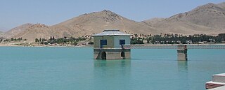
Qargha is a dam and reservoir at Qargha near Kabul, in Afghanistan. The reservoir and its peripheral areas offer recreation facilities such as boating, surfing, golfing, etc., and include a hotel. There is a fishery development in the reservoir supported by a hatchery on its banks. Irrigation and hydropower developments have also been planned from the stored waters of the reservoir.

<span class="mw-page-title-main">Camanche Dam</span> Dam in San Joaquin County, California

Camanche Dam is an earthfill Dam on the Mokelumne River in the central California, about 20 mi (32 km) from East Lodi. The dam and reservoir lie in the Sierra Nevada foothills in San Joaquin County. Construction of Camanche Dam was started in 1963 and completed in 1964. East Bay Municipal Utilities District (EBMUD) owns and operates it. The purpose of Camanche Dam and reservoir is to provide flood control, water flows for agriculture, habitat for fisheries and recreation for community.

<span class="mw-page-title-main">Caples Lake</span> Reservoir in California

Caples Lake is a reservoir that is located near Kirkwood, California along California State Route 88. The lake was used as a halting place for wagon travelers who were trekking the historic Mormon Trail during the California Gold Rush. The lake has been used by many different groups of people including Native Americans, 49ers, and resort owners, so it has been known by different names. The variant names are Clear Lake, Summit Lake, and Twin Lakes. Currently, Caples Lake is a reservoir used for water and recreation. Woods Creek and Emigrant Creek both flow into Caples Lake, which drains into Caples Creek. Caples Creek meets up with the South Fork of the American River. It is operated by the El Dorado Irrigation District (EID), who is using it as part of the Hydroelectric Project 184 system.

References

  1. 1 2 3 4 "Camanche Reservoir". Geographic Names Information System . United States Geological Survey, United States Department of the Interior.
  2. 1 2 3 4 5 "Dams Within the Jurisdiction of the State of California (A-G)" (PDF). California Department of Water Resources, Division of Safety of Dams. Archived from the original (PDF) on March 9, 2012. Retrieved October 31, 2012.
  3. "Lake Camanche".
  4. "Camanche Reservoir". East Bay Municipal Utility District. Retrieved January 9, 2015.
  5. 1 2 "Fishing at Lake Camanche". Camanche Recreation Company. Retrieved October 31, 2012.
  6. AHEARN, Dylan (June 8, 2005). "Effects of River Regulation on Water Quality in the Lower Mokelumne River, California" (PDF). watershed.ucdavis.edu. Wiley InterScience. Archived (PDF) from the original on August 21, 2016. Retrieved May 4, 2016.
  7. 1 2 "CDEC - Data Application". cdec.water.ca.gov. Retrieved May 14, 2016.
  8. "History of the Mokelumne River Hatchery". www.wildlife.ca.gov. Retrieved May 14, 2016.
  9. ebird. "eBird Checklist – Lake Camanche (Ione) yard, Amador County, CA, California – Sat Nov 21, 2015 – 37 species". eBird. Retrieved May 9, 2016.
  10. "Characteristics of mediterranean climates". gimcw.org. Archived from the original on December 17, 2015. Retrieved May 9, 2016.
  11. "Groundwater Supply Study and Integrated Regional Groundwater Management Plan for the Lake Camanche Water Improvement District No. 7" (PDF). amadorwater.org. Amador Water Agency. June 2012. Retrieved May 10, 2016.
  12. "Camanche - CalaverasHistory.org". www.calaverashistory.org. Retrieved May 9, 2016.
  13. "Boating & Marinas". Camanche Recreation Company. Retrieved October 31, 2012.
  14. "Watersports". Camanche Recreation Company. Retrieved October 31, 2012.
  15. 1 2 3 4 "Home". Lake Camanche Recreation. Retrieved May 9, 2016.