Cameron County, Pennsylvania

Last updated

Cameron County
Cameron County Courthouse, Emporium, PA.jpg
Flag of Cameron County, Pennsylvania.gif
Logo of Cameron County, Pennsylvania.png
Map of Pennsylvania highlighting Cameron County.svg
Location within the U.S. state of Pennsylvania
Pennsylvania in United States.svg
Pennsylvania's location within the U.S.
Coordinates: 41°26′N78°12′W / 41.44°N 78.2°W / 41.44; -78.2
CountryFlag of the United States.svg United States
StateFlag of Pennsylvania.svg  Pennsylvania
FoundedMarch 29, 1860
Named for Simon Cameron
Seat Emporium
Largest boroughEmporium
Area
  Total398 sq mi (1,030 km2)
  Land396 sq mi (1,030 km2)
  Water2.2 sq mi (6 km2)  0.5%
Population
 (2020)
  Total4,547
  Density11.4/sq mi (4.4/km2)
Time zone UTC−5 (Eastern)
  Summer (DST) UTC−4 (EDT)
Congressional district 15th
Website www.cameroncountypa.com
DesignatedSeptember 14, 1982 [1]

Cameron County is a county in the Commonwealth of Pennsylvania. As of the 2020 census, the population was 4,547 [2] and is Pennsylvania's least populous county. Its county seat is Emporium. [3] The county was created on March 29, 1860, from parts of Clinton, Elk, McKean, and Potter Counties. It is named for Senator Simon Cameron. The county is part of the North Central Pennsylvania region of the state. [lower-alpha 1]

Contents

Geography

According to the U.S. Census Bureau, the county has a total area of 398 square miles (1,030 km2), of which 396 square miles (1,030 km2) is land and 2.2 square miles (5.7 km2) (0.5%) is water. [4] It has a warm-summer humid continental climate (Dfb) and average monthly temperatures in Emporium range from 24.2 °F in January to 69.3 °F in July, while in Driftwood they range from 24.9 °F in January to 69.9 °F in July. [5]

Adjacent counties

Major roads

Demographics

Historical population
CensusPop.Note
1870 4,273
1880 5,15920.7%
1890 7,23840.3%
1900 7,048−2.6%
1910 7,6448.5%
1920 6,297−17.6%
1930 5,307−15.7%
1940 6,85229.1%
1950 7,0232.5%
1960 7,5868.0%
1970 7,096−6.5%
1980 6,674−5.9%
1990 5,913−11.4%
2000 5,9741.0%
2010 5,085−14.9%
2020 4,547−10.6%
U.S. Decennial Census [6]
1790–1960 [7] 1900–1990 [8]
1990–2000 [9] 2010–2017 [10]

As of the 2000 census, [11] there were 5,974 people, 2,465 households, and 1,624 families residing in the county. The population density was 15 people per square mile (5.8 people/km2). There were 4,592 housing units at an average density of 12 units per square mile (4.6/km2). The racial makeup of the county was 98.83% White, 0.35% Black or African American, 0.13% Native American, 0.12% Asian, 0.05% Pacific Islander, 0.05% from other races, and 0.47% from two or more races. 0.57% of the population were Hispanic or Latino of any race. 33.5% were of German, 15.7% Irish, 14.5% American, 13.1% Italian, 9.2% English and 5.7% Polish ancestry.

There were 2,465 households, out of which 27.70% had children under the age of 18 living with them, 52.40% were married couples living together, 9.20% had a female householder with no husband present, and 34.10% were non-families. 30.10% of all households were made up of individuals, and 15.40% had someone living alone who was 65 years of age or older. The average household size was 2.39 and the average family size was 2.96.

In the county, the population was spread out, with 24.50% under the age of 18, 6.00% from 18 to 24, 24.90% from 25 to 44, 24.80% from 45 to 64, and 19.80% who were 65 years of age or older. The median age was 41 years. For every 100 females there were 96.60 males. For every 100 females age 18 and over, there were 94.60 males.

2020 census

Cameron County Racial Composition [12]
RaceNum.Perc.
White (NH)4,27194%
Black or African American (NH)120.26%
Native American (NH)80.17%
Asian (NH)290.64%
Pacific Islander (NH)00%
Other/Mixed (NH)1413.1%
Hispanic or Latino 861.9%

Law and government

United States presidential election results for Cameron County, Pennsylvania [13]
Year Republican Democratic Third party
No.%No.%No.%
2020 1,77172.58%63425.98%351.43%
2016 1,58971.90%53124.03%904.07%
2012 1,35963.95%72434.07%421.98%
2008 1,32358.62%87938.95%552.44%
2004 1,59966.46%79433.00%130.54%
2000 1,38361.58%77934.68%843.74%
1996 1,11349.89%82236.84%29613.27%
1992 1,17343.80%82430.77%68125.43%
1988 1,73165.20%90133.94%230.87%
1984 2,03167.05%99032.68%80.26%
1980 1,79559.24%1,11236.70%1234.06%
1976 1,61654.28%1,31944.31%421.41%
1972 1,93568.45%82829.29%642.26%
1968 1,82258.96%1,10435.73%1645.31%
1964 1,37641.89%1,90457.96%50.15%
1960 2,12961.06%1,35338.80%50.14%
1956 2,46274.52%84125.45%10.03%
1952 2,30769.05%1,02030.53%140.42%
1948 1,59664.75%85834.81%110.45%
1944 1,72960.60%1,11539.08%90.32%
1940 1,79355.15%1,45044.60%80.25%
1936 1,80153.21%1,53845.44%461.36%
1932 1,43864.31%74833.45%502.24%
1928 1,56475.52%50124.19%60.29%
1924 1,36677.18%26014.69%1448.14%
1920 1,36468.06%49724.80%1437.14%
1916 71359.17%45237.51%403.32%
1912 38830.10%29122.58%61047.32%
1908 1,11065.72%53331.56%462.72%
1904 1,22873.75%40424.26%331.98%
1900 97163.59%51433.66%422.75%
1896 92559.60%57537.05%523.35%
1892 82952.37%70144.28%533.35%
1888 78258.14%55140.97%120.89%

Voter registration

As of February 7, 2024, there are 2,931 registered voters in Cameron County. [14]

Chart of Voter Registration

   Republican (62.20%)
   Democratic (25.42%)
   Independent (7.71%)
   Other Parties (4.67%)

County-row offices

State senate

State House of Representatives

United States House of Representatives

United States Senate

Education

Public school districts

Recreation

There are three Pennsylvania state parks that are partly in Cameron County.

The West Creek Rail Trail has been built on the abandoned rail corridor between Emporium and St. Mary's in Elk County. It provides a paved surface with guard rails and is suitable for hiking or biking in the warm seasons or snowmobiling in winter. [15]

The Fred Woods Trail offers a 4.57 mile loop of blazed trail with scenic valley views and a challenging section running through unique rock formations. The trailhead is accessed off Mason Hill Road above Driftwood, PA. [16] [17] [18]

Communities

Map of Cameron County, Pennsylvania with Municipal Labels showing Boroughs (red) and Townships (white). Map of Cameron County Pennsylvania With Municipal and Township Labels.png
Map of Cameron County, Pennsylvania with Municipal Labels showing Boroughs (red) and Townships (white).

Under Pennsylvania law, there are four types of incorporated municipalities: cities, boroughs, townships, and, in at most two cases, towns. The following boroughs and townships are located in Cameron County:

Boroughs

Townships

Census-designated place

Population ranking

The population ranking of the following table is based on the 2010 census of Cameron County. [19]

county seat

RankCity/Town/etc.Population (2010 Census)Municipal typeIncorporated
1Emporium 2,073Borough1864
2 Prospect Park 327CDP
3 Driftwood 67Borough1872

Notable people

Related Research Articles

<span class="mw-page-title-main">Warren County, Pennsylvania</span> County in Pennsylvania, United States

Warren County is a county in the Commonwealth of Pennsylvania. As of the 2020 census, the population was 38,587. Its county seat is Warren. The county was established in 1800 from parts of Allegheny and Lycoming counties; attached to Crawford County until 1805 and then to Venango County until Warren was formally established in 1819.

<span class="mw-page-title-main">Potter County, Pennsylvania</span> County in Pennsylvania, United States

Potter County is a county in the Commonwealth of Pennsylvania. As of the 2020 census, its population was 16,396, making it the fifth-least populous county in Pennsylvania. Its county seat is Coudersport. The county was created in 1804 and later organized in 1836. It is named after James Potter, who was a general from Pennsylvania in the Continental Army during the American Revolution. Due to its remoteness and natural environment, it has been nicknamed “God's Country”.

<span class="mw-page-title-main">McKean County, Pennsylvania</span> County in Pennsylvania, United States

McKean County is a rural county in the Commonwealth of Pennsylvania. As of the 2020 census, the population was 40,432. Its county seat is Smethport. The county was created in 1804 and organized in 1826. It was named in honor of former Pennsylvania Governor and Declaration of Independence signer Thomas McKean. The county is part of the North Central Pennsylvania region of the state.

<span class="mw-page-title-main">Forest County, Pennsylvania</span> County in Pennsylvania, United States

Forest County is a county in the Commonwealth of Pennsylvania. As of the 2020 census, the population was 6,973, making it the third-least populous county in Pennsylvania. Its county seat is Tionesta. The county was created in 1848 and later organized in 1857. The county is part of the North Central Pennsylvania region of the state.

<span class="mw-page-title-main">Elk County, Pennsylvania</span> County in Pennsylvania, United States

Elk County is a county in the Commonwealth of Pennsylvania. As of the 2020 United States census, the population was 30,990. Its county seat is Ridgway. The county was created on April 18, 1843, from parts of Jefferson, Clearfield, and McKean Counties. Elk County is named for the eastern elk that historically inhabited the region. The county is part of the North Central Pennsylvania region of the state.

<span class="mw-page-title-main">Clarion County, Pennsylvania</span> County in Pennsylvania, United States

Clarion County is a county in the Commonwealth of Pennsylvania. As of the 2020 census, the population was 37,241. Its county seat is Clarion. The county was formed on March 11, 1839, from parts of Venango and Armstrong counties. Clarion County is entirely defined as part of the Pittsburgh media market. The county is part of the North Central Pennsylvania region of the state.

<span class="mw-page-title-main">Emporium, Pennsylvania</span> Borough in Pennsylvania, United States

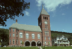
Emporium is a borough and the county seat of Cameron County in the U.S. state of Pennsylvania. It is located 100 miles (160 km) west-northwest of Williamsport. Early in the twentieth century, there were large power plants and manufacturers of radio tubes and incandescent lamps, paving brick, flour, iron, lumber, and sole leather. In 1900, 2,463 people lived in Emporium, and in 1910, the population was 2,916. By 2010, the population had dropped to 2,073, and at the 2020 census, the population was 1,961.

<span class="mw-page-title-main">Gibson Township, Cameron County, Pennsylvania</span> Township in Pennsylvania, United States

Gibson Township is a township in Cameron County, Pennsylvania, United States. The population was 178 at the 2020 census, up from 164 in 2010, which in turn was a decline from the figure of 222 in 2000.

<span class="mw-page-title-main">Lumber Township, Pennsylvania</span> Township in Pennsylvania, United States

Lumber Township is a township in Cameron County, Pennsylvania, United States. The population was 178 at the 2020 census, down from 195 in 2010.

<span class="mw-page-title-main">Portage Township, Cameron County, Pennsylvania</span> Township in Pennsylvania, United States

Portage Township is a township in Cameron County, Pennsylvania, United States. The population was 163 at the 2020 census, down from 171 in 2010.

<span class="mw-page-title-main">Shippen Township, Cameron County, Pennsylvania</span> Township in Pennsylvania, United States

Shippen Township is a township in Cameron County, Pennsylvania, United States. The population was 1,922 at the 2020 census. The borough of Emporium, the county seat, lies enclaved within the eastern part of the township, but is not part of it.

<span class="mw-page-title-main">South Renovo, Pennsylvania</span> Borough in Pennsylvania, United States

South Renovo is a borough in Clinton County, Pennsylvania, United States, located on the West Branch Susquehanna River, directly across from Renovo. The population was 439 at the 2010 census, down from 557 in 2000.

<span class="mw-page-title-main">Benezette Township, Pennsylvania</span> Township in Pennsylvania, United States

Benezette Township is a township in Elk County, Pennsylvania, United States. The population was 217 at the 2020 census, up from 207 in 2010.

<span class="mw-page-title-main">Millstone Township, Pennsylvania</span> Township in Pennsylvania, United States

Millstone Township is a township in Elk County, Pennsylvania, United States. The population was 95 at the 2020 census, up from 82 in 2010.

<span class="mw-page-title-main">Elk State Forest</span> State forest in Pennsylvania, United States

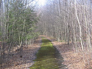
Elk State Forest is a Pennsylvania State Forest in Pennsylvania Bureau of Forestry District #13. The main offices are located in Emporium in Cameron County, Pennsylvania.

<span class="mw-page-title-main">Elk State Park</span>

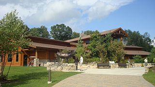
Elk State Park is a 3,192-acre (1,292 ha) Pennsylvania state park in Jones Township, Elk County and Sergeant Township, McKean County, Pennsylvania, in the United States. East Branch Clarion River Lake is a man-made lake covering 1,160 acres (470 ha) within the park. The lake and streams in the park are stocked with cold and warm water fish. There are 3,151 acres (1,275 ha) of woods open to hunting.

<span class="mw-page-title-main">Sizerville State Park</span> State park near Emporium, Pennsylvania

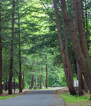
Sizerville State Park is a 386-acre (156 ha) Pennsylvania state park in Portage Township, Cameron County and Portage Township, Potter County, Pennsylvania in the United States. The park is nearly surrounded by Elk State Forest making it part of one of the largest blocks of state-owned land in Pennsylvania. Sizerville State Park is on Pennsylvania Route 155, six miles (10 km) north of the borough of Emporium.

<span class="mw-page-title-main">Sinnemahoning State Park</span> State park in Cameron and Potter counties, Pennsylvania

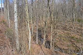
Sinnemahoning State Park is a 1,910-acre (773 ha) Pennsylvania state park in Grove Township, Cameron County and Wharton Township, Potter County, Pennsylvania, in the United States. The park is surrounded by Elk State Forest and is mountainous with deep valleys. The park is home to the rarely seen elk and bald eagle. Sinnemahoning State Park is on Pennsylvania Route 872, eight miles (13 km) north of the village of Sinnamahoning. In 1958, the park opened under the direction of the Pennsylvania Bureau of Forestry: it became a Pennsylvania State Park in 1962.

<span class="mw-page-title-main">Bucktail State Park Natural Area</span>

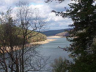
Bucktail State Park Natural Area is a 16,433-acre (6,650 ha) Pennsylvania state park in Cameron and Clinton Counties in Pennsylvania in the United States. The park follows Pennsylvania Route 120 for 75 miles (121 km) between Emporium and Lock Haven. Bucktail State Park Natural Area park runs along Sinnemahoning Creek and the West Branch Susquehanna River and also passes through Renovo. The park is named for the Civil War Pennsylvania Bucktails Regiment and is primarily dedicated to wildlife viewing, especially elk.

<span class="mw-page-title-main">Pennsylvania Route 155</span> State highway in Pennsylvania, US

Pennsylvania Route 155 is a 32.2-mile-long (51.8 km) state highway located in Cameron, Potter, and McKean counties in Pennsylvania. The southern terminus is at PA 120 in Emporium. The northern terminus is at PA 446 in Eldred Township.

References

  1. Includes Clearfield, Jefferson, Tioga, McKean, Warren, Clarion, Elk, Potter, Forest and Cameron Counties
  1. "PHMC Historical Markers Search". Pennsylvania Historical and Museum Commission. Commonwealth of Pennsylvania. Archived from the original (Searchable database) on March 21, 2016. Retrieved January 25, 2014.
  2. "Census - Geography Profile: Cameron County, Pennsylvania". United States Census Bureau. Archived from the original on November 27, 2022. Retrieved April 24, 2022.
  3. "Find a County". National Association of Counties. Archived from the original on May 31, 2011. Retrieved June 7, 2011.
  4. "2010 Census Gazetteer Files". United States Census Bureau. August 22, 2012. Archived from the original on September 4, 2015. Retrieved March 5, 2015.
  5. "PRISM Climate Group at Oregon State University". Archived from the original on July 25, 2019. Retrieved November 9, 2019.
  6. "U.S. Decennial Census". United States Census Bureau. Archived from the original on November 8, 2020. Retrieved March 5, 2015.
  7. "Historical Census Browser". University of Virginia Library. Archived from the original on August 11, 2012. Retrieved March 5, 2015.
  8. Forstall, Richard L., ed. (March 24, 1995). "Population of Counties by Decennial Census: 1900 to 1990". United States Census Bureau. Archived from the original on March 20, 2015. Retrieved March 5, 2015.
  9. "Census 2000 PHC-T-4. Ranking Tables for Counties: 1990 and 2000" (PDF). United States Census Bureau. April 2, 2001. Archived (PDF) from the original on March 27, 2010. Retrieved March 5, 2015.
  10. "State & County QuickFacts". United States Census Bureau. Archived from the original on June 6, 2011. Retrieved November 16, 2013.
  11. "U.S. Census website". United States Census Bureau. Archived from the original on December 27, 1996. Retrieved January 31, 2008.
  12. "P2 HISPANIC OR LATINO, AND NOT HISPANIC OR LATINO BY RACE – 2020: DEC Redistricting Data (PL 94-171) – Cameron County, Pennsylvania". Archived from the original on September 25, 2022. Retrieved September 25, 2022.
  13. Leip, David. "Dave Leip's Atlas of U.S. Presidential Elections". uselectionatlas.org. Archived from the original on March 23, 2018. Retrieved November 21, 2018.
  14. Pennsylvania Department of State (February 5, 2024). "Voter registration statistics by county". dos.pa.gov. Archived from the original on August 17, 2016. Retrieved February 7, 2024.
  15. "PROJECT TRAIL: West Creek Recreational Trail | Pennsylvania Trails | TrailLink.com". Archived from the original on February 19, 2015. Retrieved February 19, 2015.
  16. Article title [ bare URL PDF ]
  17. "Fred Woods Trail". VisitPA - #visitPA. Archived from the original on November 22, 2018. Retrieved November 21, 2018.
  18. "Fred Woods Trail Description". www.wapitiwoods.com. Archived from the original on November 22, 2018. Retrieved November 21, 2018.
  19. "2010 U.S. Census website". United States Census Bureau. Archived from the original on May 22, 2017. Retrieved February 10, 2013.

41°26′N78°12′W / 41.44°N 78.20°W / 41.44; -78.20