Related Research Articles
Marine Corps Base Quantico is a United States Marine Corps installation located near Triangle, Virginia, covering nearly 55,148 acres (86.169 sq mi) of southern Prince William County, Virginia, northern Stafford County, and southeastern Fauquier County. Used primarily for training purposes, MCB Quantico is known as the "Crossroads of the Marine Corps".

Arlington Hall is a historic building in Arlington, Virginia, originally a girls' school and later the headquarters of the United States Army's Signal Intelligence Service (SIS) cryptography effort during World War II. The site presently houses the George P. Shultz National Foreign Affairs Training Center, and the Army National Guard's Herbert R. Temple, Jr. Readiness Center. It is located on Arlington Boulevard between S. Glebe Road and S. George Mason Drive.

The National Reconnaissance Office (NRO) is a member of the United States Intelligence Community and an agency of the United States Department of Defense which designs, builds, launches, and operates the reconnaissance satellites of the U.S. federal government, and provides satellite intelligence to several government agencies, particularly signals intelligence (SIGINT) to the NSA, imagery intelligence (IMINT) to the NGA, and measurement and signature intelligence (MASINT) to the DIA.
The Foreign Broadcast Information Service (FBIS) was an open source intelligence component of the Central Intelligence Agency's Directorate of Science and Technology. It monitored, translated, and disseminated within the U.S. government openly available news and information from media sources outside the United States. Its headquarters was in Rosslyn, Virginia 38.8959°N 77.0727°W, later Reston, Virginia 38.955°N 77.359°W, and it maintained approximately 20 monitoring stations worldwide. In November 2005, it was announced that FBIS would become the newly formed Open Source Center, tasked with the collection and analysis of freely available intelligence.

Vaucluse was a villa in Fairfax County, Virginia, three miles (5 km) from Alexandria and 10 miles (16 km) from Washington, D.C., on a hill near the Virginia Theological Seminary, that was owned first by Dr. James Craik, and later by the Fairfax family, the first being Thomas Fairfax, 9th Lord Fairfax of Cameron.

The Civil War Defenses of Washington were a group of Union Army fortifications that protected the federal capital city, Washington, D.C., from invasion by the Confederate States Army during the American Civil War. The sites of some of these fortifications are within a collection of National Park Service (NPS) properties that the National Register of Historic Places identifies as the Fort Circle. The sites of other such fortifications in the area have become parts of state, county or city parks or are located on privately owned properties. A trail connecting the sites is part of the Potomac Heritage Trail.

The Washington Air Defense Sector (WaADS) is an inactive United States Air Force organization. Its last assignment was with the Air Defense Command (ADC) 26th Air Division, being stationed at Fort Lee Air Force Station (AFS), Virginia. It was inactivated on 1 April 1966.

Vint Hill Farms Station (VHFS) was a United States Army and National Security Agency (NSA) signals intelligence and electronic warfare facility located in Fauquier County, Virginia, near Warrenton. VHFS was closed in 1997 and the land was sold off in 1999. Today the site hosts various engineering and technology companies, as well as two Federal Aviation Administration (FAA) air traffic control facilities.
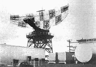
The AN/FPS-24 Radar was a long range early warning radar used by the United States Air Force Air Defense Command. It used a two-frequency signal in order to avoid fluctuation loss, which causes signals on single-frequency radars to fade in and out as the target moves. Reducing this effect results in a much steadier signal.
Manassas Air Force Station is a closed United States Air Force General Surveillance Radar station. It is located 7.4 miles (11.9 km) west of Dale City, Virginia. It was closed in 1965.

Snow Mountain Air Force Station is a closed United States Air Force General Surveillance Radar station. It is located 1.9 miles (3.1 km) west-southwest of Godman Army Airfield, Kentucky. It was closed in 1968.

Havre Air Force Station is a Formerly Used Defense Site that was used as a Cold War general surveillance radar station. In addition to radar facilities and a NORAD Control Center the site had support services: NCO club, bowling alley, hobby shops, library, movie theater, barber shop, exchange, commissary, grade school, and housing for officers and senior NCOs.

Colville Air Force Station is a closed United States Air Force General Surveillance Radar station. It is located 14.7 miles (23.7 km) east-northeast of Colville, Washington. It was closed in 1961.

Red Cliff Air Station was a General Surveillance Radar station. The remains of which are located 5.8 miles (9.3 km) north-northeast of St. John's, Newfoundland and Labrador, Canada. It was closed in 1961.

The Holmes Run Trail is a partially paved trail that travels through parks northwest along Holmes Run from Cameron Run in Alexandria, Virginia to Annandale Road in Fairfax County, Virginia. The trail travels near the sides of the stream with multiple bridges, some of which are only about a foot higher than the water. The trail consists of two sections that are separated by Lake Barcroft near Columbia Pike in Fairfax County.

The Mark Center Building is a United States military installation and office building in Alexandria, Virginia. It is operated by the Washington Headquarters Services (WHS) of the United States Department of Defense (DoD), and provides office space for several other DoD agencies. The name of the site refers to the "Mark Center" property development in which it is located, at the intersection of Seminary Road and Beauregard Street at the Interstate 395 interchange.

Hutchinson Air Force Station is a closed United States Air Force station. It is located 2 miles (3.2 km) west-southwest of Yoder, Kansas. It was closed for all military use in 1968. It was operated alongside Hutchinson Air National Guard Base when it was operational.
The 1988 Base Realignment and Closure Commission preliminary list was released by the United States Department of Defense in 1988 as part of the Base Realignment and Closure Commission. It recommended closing 17 major United States military bases.
Warrenton Training Center (WTC) is a classified United States government communication complex located in the state of Virginia. Established in 1951, it comprises four discrete stations located in Fauquier and Culpeper counties.

U.S. Naval Torpedo Station, Alexandria was a facility of the United States Navy, located in Alexandria, Virginia, that existed from 1918 to 1945. After its closure, it was redeveloped into the Torpedo Factory Art Center.
References
- ↑ Andrews, Robert M. (February 2, 1989). "Military shoppers will mourn loss of Cameron Station". The Free Lance-Star. Associated Press . Retrieved 17 June 2015.
Coordinates: 38°48′24.48″N77°7′12.62″W / 38.8068000°N 77.1201722°W