Camp Swift, Texas

Last updated

Camp Swift, Texas
View of the Main Entrance at Camp Swift Texas, August 6, 1944.jpg
Main entrance to the Camp Swift facility of the 10th Mountain Division during World War II
Bastrop CampSwift.svg
Coordinates: 30°11′2″N97°17′52″W / 30.18389°N 97.29778°W / 30.18389; -97.29778
Country United States
State Texas
County Bastrop
Area
  Total12.1 sq mi (31.4 km2)
  Land12.0 sq mi (31.2 km2)
  Water0.08 sq mi (0.2 km2)
Elevation
440 ft (134 m)
Population
 (2020)
  Total7,943
  Density660/sq mi (250/km2)
Time zone UTC-6 (Central (CST))
  Summer (DST) UTC-5 (CDT)
Zip Code
78602
FIPS code 48-12334 [1]
GNIS feature ID1867544 [2]

Camp Swift is a census-designated place (CDP) in Bastrop County, Texas, United States. The population was 7,943 at the 2020 census. [3] Camp Swift began as a United States Army training base built in 1942. It is named after Major General Eben Swift.

Contents

History

The Army signed a $25 million contract in January 1942 to build a training camp on 56,000 acres north of Bastrop, Texas. The contract stipulated the project was to be completed in 108 working days. Twenty-seven hundred buildings were built during World War II, but none of those remain on the site today. At the end of the war, they were sold or donated and relocated. The gymnasium was relocated to Whitney, Texas. It is still in use today by the school district.

During World War II, German prisoners of war began arriving and at peak numbered 10,000. At the same time, the camp held 90,000 GIs, making it "one of the largest army training and transshipment camps in Texas" according to Krammer. [4]

In December 1942, Sgt Walter Springs was gunned down by a White military police officer following a dispute as Springs was reporting to Camp Swift. Springs was shot in the back, but the case remains largely unsolved to this day. A memorial scholarship in his honor has been active at his alma mater, Regis University, for most of the period since 1952 and has the backing of former NBA All Star Chauncey Billups. [5]

The 10th Mountain Division trained at Camp Swift in 1944. The 2nd Infantry Division trained there mid 1945 to early 1946. The camp also trained nurses under battlefield conditions. The camp trained some 300,000 soldiers before the war ended.

After World War II, most of the land was returned to its former owners. The U.S. government retained 11,700 acres as a military reservation as well as a smaller parcel for FCI Bastrop. [6]

The Texas Wing of the Civil Air Patrol, the Auxiliary of the Air Force has held its encampment, a one-week high intensity simulated military training program for Cadet (leaders in training) members in Camp Swift since 2011. [7]

Current Operations

Camp Swift military reservation CampSwift.jpg
Camp Swift military reservation

Camp Swift is currently owned by the United States Army Corps of Engineers, [8] but is managed by the Texas Military Forces headquartered on Camp Mabry in Austin and acts as a training center for the National and State Guard, active armed forces, law enforcement, JROTC and the Civil Air Patrol. The camp is also the primary emergency staging area for Central Texas. [9] Camp Swift is also the primary site for pre-mobilization training for the Texas Army National Guard. [10]

Beginning in 2007, Camp Swift became home to the 136th Combat Arms Training Regiment and Texas National Guard Training Center of Excellence. [11] The 136th Regiment conducts military occupational specialty qualification courses, Noncommissioned Officer Education System courses, Officer Candidate School, Warrant Officer Candidate School, and other specialty courses. [12]

Camp Swift has educational facilities and classrooms, a gas chamber, an airborne drop zone, rifle and pistol ranges, helicopter landing sites and a land navigation course. [11]

Geography

Camp Swift is located north of the center of Bastrop County at 30°11′02″N97°17′52″W / 30.183879°N 97.297684°W / 30.183879; -97.297684 . [13] It is about 37 miles (60 km) east of Austin and 7 miles (11 km) north of Bastrop. Texas State Highway 95 forms the western edge of the community, connecting Bastrop to the south with Elgin to the north.

According to the United States Census Bureau, the CDP has a total area of 12.1 square miles (31.4 km2), of which 12.0 square miles (31.2 km2) is land and 0.08 square miles (0.2 km2), or 0.65%, is water. [3]

Demographics

Camp Swift racial composition as of 2020 [14]
(NH = Non-Hispanic) [lower-alpha 1]
RaceNumberPercentage
White (NH)2,47631.17%
Black or African American (NH)4575.75%
Native American or Alaska Native (NH)300.38%
Asian (NH)220.28%
Some Other Race (NH)370.47%
Mixed/Multi-Racial (NH)1391.75%
Hispanic or Latino 4,78260.2%
Total7,943

As of the 2020 United States census, there were 7,943 people, 1,444 households, and 1,025 families residing in the CDP.

As of the census [1] of 2000, there were 4,731 people, 1,127 households, and 849 families residing in the CDP. The population density was 396.2 inhabitants per square mile (153.0/km2). There were 1,231 housing units at an average density of 103.1 per square mile (39.8/km2). The racial makeup of the CDP was 73.28% White, 8.84% African American, 1.16% Native American, 0.25% Asian, 0.06% Pacific Islander, 13.11% from other races, and 3.30% from two or more races. Hispanic or Latino of any race were 37.88% of the population.

There were 1,127 households, out of which 40.1% had children under the age of 18 living with them, 58.2% were married couples living together, 10.9% had a female householder with no husband present, and 24.6% were non-families. 19.3% of all households were made up of individuals, and 4.4% had someone living alone who was 65 years of age or older. The average household size was 2.98 and the average family size was 3.40.

In the CDP, the population was spread out, with 22.6% under the age of 18, 8.9% from 18 to 24, 42.5% from 25 to 44, 21.1% from 45 to 64, and 5.0% who were 65 years of age or older. The median age was 34 years. For every 100 females, there were 185.9 males. For every 100 females age 18 and over, there were 224.0 males.

The median income for a household in the CDP was $41,833, and the median income for a family was $44,352. Males had a median income of $30,572 versus $25,044 for females. The per capita income for the CDP was $12,829. About 9.2% of families and 11.6% of the population were below the poverty line, including 9.6% of those under age 18 and 25.7% of those age 65 or over.

Government and infrastructure

Federal Correctional Institution Bastrop, a prison of the Federal Bureau of Prisons (BOP), is in Camp Swift. [16]

Education

Camp Swift is served by the Bastrop Independent School District. [17] [18] Most residents are zoned to Lost Pines Elementary School, [19] while a small southern section is zoned to Mina Elementary School. [20] All residents are zoned to Bastrop Intermediate School, Bastrop Middle School, and Bastrop High School. [21]

See also

Related Research Articles

<span class="mw-page-title-main">Bastrop County, Texas</span> County in Texas, United States

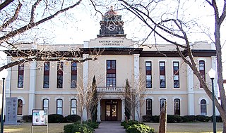
Bastrop County is located in the U.S. state of Texas. It is in Central Texas and its county seat is Bastrop.

<span class="mw-page-title-main">Fort Washington, Maryland</span> Census-designated place in Maryland

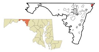
Fort Washington is an unincorporated area and census-designated place in Prince George's County, Maryland, United States. It borders the Potomac River, situated 20 miles south of the downtown Washington, DC. As of the 2020 census it had a population of 24,261. The Fort Washington community is located west of Maryland Route 210, with some additional area to the east of the highway.

<span class="mw-page-title-main">Fort Ritchie, Maryland</span> CDP in Maryland, United States

Fort Ritchie is a census-designated place (CDP) in Washington County, Maryland, United States, just south of the Pennsylvania state line. The population was 276 at the 2000 census. Fort Ritchie is a former U.S. military base that closed in September 1998, pursuant to the 1995 Base Realignment and Closure Commission. Blue Ridge Summit, Pennsylvania is immediately to the north.

<span class="mw-page-title-main">Bastrop, Texas</span> City in Texas, United States

Bastrop is a city and the county seat of Bastrop County, Texas, United States. The population was 9,688 according to the 2020 census. It is located about 30 mi (48 km) southeast of Austin and is part of the Greater Austin metropolitan area.

<span class="mw-page-title-main">Circle D-KC Estates, Texas</span> CDP in Texas, United States

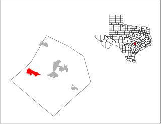
Circle D-KC Estates is a census-designated place (CDP) in Bastrop County, Texas, United States. The population was 2,588 at the 2020 census.

<span class="mw-page-title-main">Wyldwood, Texas</span> CDP in Texas, United States

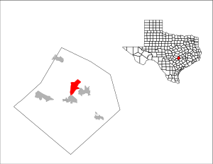
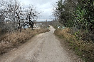
Wyldwood is a census-designated place (CDP) in Bastrop County, Texas, United States. The population was 3,694 at the 2020 census.

<span class="mw-page-title-main">Canutillo, Texas</span> Census-designated place in Texas, United States

Canutillo is a census-designated place (CDP) in El Paso County, Texas, United States. The population was 6,321 at the 2010 census. It is part of the El Paso Metropolitan Statistical Area. The ZIP Codes encompassing the CDP area are 79835 and 79932.

<span class="mw-page-title-main">Citrus City, Texas</span> Census-designated place in Texas

Citrus City is a census-designated place (CDP) in Hidalgo County, Texas. The population was 3,291 at the 2020 US Census. It is part of the McAllen–Edinburg–Mission Metropolitan Statistical Area. The town was founded in 1943 during World War II by Howard Moffitt, a builder known for his vernacular Moffitt cottage architectural style, as part of a planned regional orange and grapefruit growing community. The local irrigation system proved to be too saline for fruit production, and the plans for a large town were revised. A few Moffitt houses survive in Citrus City.

<span class="mw-page-title-main">Cuevitas, Texas</span> Census-designated place in Texas

Cuevitas is a census-designated place (CDP) in Hidalgo County, Texas. The population was 40 at the 2010 United States Census. Rated the poorest community in Texas, it is part of the McAllen–Edinburg–Mission Metropolitan Statistical Area.

<span class="mw-page-title-main">Los Ebanos, Hidalgo County, Texas</span> Census-designated place in Texas

Los Ebanos is a census-designated place (CDP) in Hidalgo County, Texas. The population was 335 at the 2010 United States Census. It is part of the McAllen–Edinburg–Mission Metropolitan Statistical Area. The city is named after the Texas Ebony that anchors the Los Ebanos Ferry.

<span class="mw-page-title-main">Midway South, Texas</span> Census-designated place in Texas

Midway South is a census-designated place (CDP) in Hidalgo County, Texas. The population was 2,239 at the 2010 United States Census. It is part of the McAllen–Edinburg–Mission Metropolitan Statistical Area.

<span class="mw-page-title-main">North Alamo, Texas</span> Census-designated place in Texas, United States

North Alamo is a census-designated place (CDP) in Hidalgo County, Texas. The population was 3,235 at the 2010 United States Census. It is part of the McAllen–Edinburg–Mission Metropolitan Statistical Area.

<span class="mw-page-title-main">San Carlos, Texas</span> Census-designated place in Texas

San Carlos is a community and census-designated place (CDP) in Hidalgo County, Texas. The population was 3,130 at the 2010 United States Census. It is part of the McAllen–Edinburg–Mission Metropolitan Statistical Area.

<span class="mw-page-title-main">Villa Verde, Texas</span> Census-designated place in Texas

Villa Verde is a census-designated place (CDP) in Hidalgo County, Texas. The population was 874 at the 2010 United States Census. It is part of the McAllen–Edinburg–Mission Metropolitan Statistical Area.

<span class="mw-page-title-main">Escobares, Texas</span> City in Texas, United States

Escobares is a city in Starr County, Texas, United States. The population was 2,588 at the 2020 census. The city was formed in 2005 from part of the deleted Escobares CDP, and parts of Garceno, and North Escobares CDPs, and additional area. Prior to its 2005 incorporation as a city, it was a census-designated place (CDP). The population of the CDP was 1,954 at the 2000 census.

<span class="mw-page-title-main">Falcon Heights, Texas</span> CDP in Texas, United States

Falcon Heights is a census-designated place (CDP) in Starr County, Texas, United States. The population was 18 at the 2020 census, down from 53 at the 2010 census.

<span class="mw-page-title-main">La Rosita, Texas</span> CDP in Texas, United States

La Rosita is a census-designated place (CDP) in Starr County, Texas, United States. The population was 85 at the 2010 census down from 1,729 at the 2000 census. This is because the Census Bureau redefined the CDP.

<span class="mw-page-title-main">Roma Creek, Texas</span> CDP in Texas, United States

Roma Creek is a former census-designated place (CDP) in Starr County, Texas, United States. The population was 350 at the 2010 census down from 610 at the 2000 census.

<span class="mw-page-title-main">Salineño, Texas</span> CDP in Texas, United States

Salineño is a census-designated place (CDP) in Starr County, Texas, United States. The name was changed in 2008, adding a tilde over the second n. The population was 176 at the 2020 census, down from 201 at the 2010 census.

<span class="mw-page-title-main">Bastrop Independent School District</span> School district in Texas

Bastrop Independent School District is a public school district in Bastrop, Texas, United States. The district serves the communities of Bastrop, Camp Swift, Cedar Creek, Circle D-KC Estates, Paige, Red Rock, Rockne, Wyldwood, and other rural areas of Bastrop County.

References

  1. 1 2 "U.S. Census website". United States Census Bureau . Retrieved January 31, 2008.
  2. "US Board on Geographic Names". United States Geological Survey. October 25, 2007. Retrieved January 31, 2008.
  3. 1 2 "Geographic Identifiers: 2010 Demographic Profile Data (G001): Camp Swift CDP, Texas". U.S. Census Bureau, American Factfinder. Archived from the original on February 12, 2020. Retrieved April 9, 2014.
  4. Krammer, Arnold (1979). Nazi Prisoners of War in America . New York: Stein and Day. p.  90,260. ISBN   0812825713.
  5. Reed, Byron (May 17, 2021). "Regis University restarting scholarship named for Walter Springs". KUSA.com. Retrieved June 6, 2021.
  6. "Camp Swift". Archived from the original on August 11, 2023. Retrieved January 29, 2024.
  7. https://www.capmembers.com/cadet_programs/activities/encampment/winter-2016-encampments/%5B%5D
  8. "Property Details". Archived from the original on January 30, 2024. Retrieved January 29, 2024.
  9. Crowell, Ed (December 2014). "Camp Swift". Texas Co-op Power: 26, 27.
  10. "REPI Program Project Profile Camp Swift" (PDF). Archived from the original (PDF) on January 30, 2024. Retrieved January 29, 2024.
  11. 1 2 "Camp Swift". Archived from the original on November 6, 2023. Retrieved January 29, 2024.
  12. "136th Regiment (Combat Arms) (Regional Training Institute)". Archived from the original on January 30, 2024. Retrieved January 29, 2024.
  13. "US Gazetteer files: 2010, 2000, and 1990". United States Census Bureau. February 12, 2011. Retrieved April 23, 2011.
  14. "Explore Census Data". data.census.gov. Retrieved May 24, 2022.
  15. "About the Hispanic Population and its Origin". www.census.gov. Retrieved May 18, 2022.
  16. "2020 CENSUS - CENSUS BLOCK MAP (INDEX): Camp Swift CDP, TX" (PDF). U.S. Census Bureau. p. 1 (PDF p. 2/3). Retrieved December 3, 2022. Federal Correctional Institution Bastrop
  17. "2010 CENSUS - CENSUS BLOCK MAP: Camp Swift CDP, TX." U.S. Census Bureau. Retrieved on January 23, 2017.
  18. "District Boundary/Attendance Maps" (Archive). Bastrop Independent School District. Retrieved on January 23, 2017. The zone map shows most of Camp Swift as being within the Lost Pines Elementary zone with a segment in the Mina zone. "Bastrop feeder pattern: Bastrop High School, Bastrop Middle School, Bastrop Intermediate School,[...]Lost Pines Elementary,[...]"
  19. "Lost Pines Elementary Attendance Boundary." Bastrop Independent School District. Retrieved on January 23, 2017.
  20. "Mina Elementary Attendance Boundary." Bastrop Independent School District. Retrieved on January 23, 2017.
  21. "Bastrop ISD Attendance Boundaries." Bastrop Independent School District. Retrieved on January 23, 2017.
  1. Note: the US Census treats Hispanic/Latino as an ethnic category. This table excludes Latinos from the racial categories and assigns them to a separate category. Hispanics/Latinos can be of any race. [15]