Related Research Articles
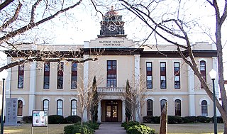
Bastrop County is a county in the U.S. state of Texas. As of the 2010 census, the population was 74,171. Its county seat is Bastrop. The county was created in 1834 as a municipality of Mexico and organized as a county in 1837. It is named for Felipe Enrique Neri, Baron de Bastrop, an early Dutch settler who helped Stephen F. Austin obtain land grants in Texas.

Bastrop is a city and the county seat of Bastrop County, Texas, United States. Located about 30 mi (48 km) southeast of Austin, it is part of the Greater Austin metropolitan area. The population was 7,218 according to the 2010 census.

Smithville is a city in Bastrop County, Texas, United States, near the Colorado River. The population was 3,817 at the 2010 census. Smithville is part of the Greater Austin metropolitan area.
Jeddo is an unincorporated community in Bastrop County, Texas, United States. Its elevation is 463 feet (141 m).
Kovar is an unincorporated community in Bastrop County, Texas, United States.

Paige is an unincorporated community in Bastrop County, Texas, United States. Although it is unincorporated, Paige has a post office, with the ZIP code of 78659.
Upton is an unincorporated community in Bastrop County, Texas, United States.
Togo is an unincorporated community in Bastrop County, Texas, United States.

Alum Creek is an unincorporated community in Bastrop County, Texas, United States.
Rockne is an unincorporated community in Bastrop County, Texas, United States. It was named after Knute Rockne. In 1931, the children of Sacred Heart School were given the opportunity to name their town. A vote was taken, with the children electing to name the town after Rockne, who had died in a plane crash earlier that year. On March 10, 1988, Rockne opened its post office for one day, during which a Knute Rockne twenty-two-cent commemorative stamp was issued. A life size bust of Rockne was unveiled on March 4, 2006 and sits in front of the Rockne Museum.
Bateman is an unincorporated community in Bastrop County, Texas, United States. The town is located on Farm to Market Road 86, five miles southwest of Red Rock, 18 miles southwest of Bastrop and 45 miles southeast of Austin.
Farm to Market Road 535 is a 33.4-mile (53.8 km) state-maintained roadway located in Bastrop County in the US State of Texas that is a part of the state's Farm to Market Road system.
Hills Prairie, or Hill's Prairie, is an unincorporated community in Bastrop County, Texas, United States. It is located off Farm to Market Road 304, 8 miles (13 km) southeast of the town of Bastrop, 8 miles (13 km) northwest of Smithville and 40 miles (64 km) southeast of Austin.
Watterson is an unincorporated community in Bastrop County, Texas, United States. The town is located on Old Watterson Road, 4 miles (6.4 km) east of Rockne, 11 miles (18 km) south of the town of Bastrop, 25 miles (40 km) west of Smithville and 40 miles (64 km) southeast of Austin.
Grassyville is a ghost town located in Bastrop County, Texas, United States. The community was founded in the northeast corner of the county near the intersection of Farm to Market Road 2104 and Farm to Market Road 2239, six miles south of Paige, 14 Miles east of the town of Bastrop and 50 miles east of Austin.

Phelan is a ghost town in Bastrop County, Texas, United States. It is located two miles north of the town of Bastrop near the intersection of Farm to Market Road 157 and Farm to Market Road 36. It is on private property.
Salem is an unincorporated community in Bastrop County, Texas, United States. It is located two miles northwest of Jeddo, 25 miles south of the town of Bastrop and 50 miles southeast of Austin. The town is one of 17 communities named Salem in the state.
McDuff is a ghost town in Bastrop County, Texas, United States. The community was located eight miles southwest of Elgin, 12 miles northwest of the town of Bastrop and 25 miles east of Austin. It was on an old stage mail route from Bastrop to Austin. Today, the town site would correspond roughly with the intersection of Farm to Market Road 969 and Upper Elgin River Road.
Oak Hill is a ghost town in Bastrop County, Texas, United States. It is located four miles southwest of McDade, 12 miles southeast of Elgin, 13 miles northeast of the town of Bastrop and 37 miles southeast of Austin on the old Bastrop-McDade Road.
Pin Oak is a ghost town in Bastrop County, Texas, United States. It is located on Farm to Market Road 2104, six miles northwest of Winchester, six miles northeast of Smithville, eight miles south of Paige and 45 miles southeast of Austin.
References
- ↑ Sitton, Thad; Conrad, James H. (2005). Freedom Colonies: Independent Black Texans in the Time of Jim Crow (Print on demand ed.). University of Texas Press. p. 191. ISBN 978-0-292-70642-2.
- ↑ Smyrl, Vivian Elizabeth. "Flower Hill Texas (Bastrop County)". Texas State Historical Association. Retrieved 16 August 2018.
Coordinates: 29°57′54″N97°07′53″W / 29.96500°N 97.13139°W
Municipalities and communities of Bastrop County, Texas, United States | ||
|---|---|---|
| Cities |  | |
| CDPs | ||
| Other unincorporated communities | ||
| Ghost towns | ||
| Footnotes | ‡This populated place also has portions in an adjacent county or counties | |