
Lycoming County is a county in the Commonwealth of Pennsylvania. As of the 2020 census, the population was 114,188. Its county seat is Williamsport.

Armstrong Township is a township in Lycoming County, Pennsylvania, United States. The population was 685 at the 2020 census. It is part of the Williamsport, Pennsylvania Metropolitan Statistical Area.

Duboistown is a borough in Lycoming County, Pennsylvania, United States. The population was 1,198 at the 2020 census. It is part of the Williamsport, Pennsylvania Metropolitan Statistical Area.

Loyalsock Township is a township in Lycoming County, Pennsylvania, United States. The population was 11,561 at the 2020 census. It is part of the Williamsport Metropolitan Statistical Area. It is the second largest municipality in Lycoming County, in terms of population, behind the county seat, Williamsport.

Williamsport is a city in, and the county seat of, Lycoming County, Pennsylvania, United States. As of the 2020 census, it had a population of 27,754. It is the principal city of the Williamsport Metropolitan Statistical Area, which has a population of about 114,000. Williamsport is the larger principal city of the Williamsport-Lock Haven Combined Statistical Area, which includes Lycoming and Clinton counties.

The West Branch Susquehanna River is one of the two principal branches, along with the North Branch, of the Susquehanna River in the Northeastern United States. The North Branch, which rises in upstate New York, is generally regarded as the extension of the main branch, with the shorter West Branch being its principal tributary.
The Williamsport Sun-Gazette is published in Williamsport, Pennsylvania, in Lycoming County. Its earliest antecedents date to 1801. As of January 1, 2016, the daily circulation of the paper was listed as 19,000 daily Monday–Saturday, with a Sunday circulation of 24,000.

White Deer Hole Creek is a 20.5-mile (33.0 km) tributary of the West Branch Susquehanna River in Clinton, Lycoming and Union counties in the U.S. state of Pennsylvania. A part of the Chesapeake Bay drainage basin, the White Deer Hole Creek watershed drains parts of ten townships. The creek flows east in a valley of the Ridge-and-valley Appalachians, through sandstone, limestone, and shale from the Ordovician, Silurian, and Devonian periods.

Susquehanna State Park is a Pennsylvania state park on 20 acres (8.1 ha) in Williamsport in Lycoming County, Pennsylvania in the United States. The park is on the West Branch Susquehanna River in the western part of Williamsport, and is operated by the Williamsport / Lycoming Chamber of Commerce in cooperation with the Bureau of State Parks of the Pennsylvania Department of Conservation and Natural Resources. Susquehanna State Park offers cruises on a paddlewheeler, boating, fishing, and picnicking.

The River Valley Transit Authority is the public transit operator serving Williamsport, Pennsylvania, and surrounding Lycoming County.

The West Branch Susquehanna Valley of central Pennsylvania, United States, in the Ridge-and-valley Appalachians, is the low-lying area draining into the West Branch Susquehanna River southeast of the Allegheny Front, northeast of the Bald Eagle Valley, southwest of the Wyoming Valley and north of the water gap formed between Shamokin Mountain and Montour Ridge.
Crestwood is a residential neighbourhood in west Edmonton, Alberta, Canada, overlooking the North Saskatchewan River valley and nestled between two ravines.
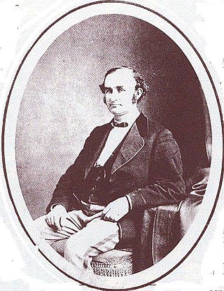
Peter Herdic (1824–1888) was a lumber baron, entrepreneur, inventor, politician, and philanthropist in Victorian era Williamsport, Lycoming County, Pennsylvania, in the United States. He was the youngest of seven children born to Henry and Elizabeth Herdic on December 14, 1824, in Fort Plain, New York. Herdic's father died in 1826 and Elizabeth Herdic remarried shortly thereafter. She was widowed again prior to 1837 when she moved her family to Pipe Creek, New York, near Ithaca. Herdic attended school for just a few years while he worked on his mother's 50-acre (200,000 m2) farm. Herdic left his mother's farm in 1846 and arrived in Lycoming County later that same year, where he settled in Cogan House Township.
The Susquehanna Boom was a system of cribs and chained logs in the West Branch Susquehanna River, designed to catch and hold floating timber until it could be processed at one of the nearly 60 sawmills along the river between Lycoming and Loyalsock Creeks in Lycoming County, Pennsylvania in the United States. The Susquehanna Boom was originally built under the supervision of James H. Perkins, and operated from 1851 to 1909, when it shut down for lack of timber.
Williamsport was incorporated as a borough on March 1, 1806, and as a city on January 15, 1866. The city is the original home of Little League Baseball, founded in 1939 as a three-team league.

Pennsylvania Route 654 is an 11.7-mile-long (18.8 km) state highway located in Lycoming County in Pennsylvania. It is known as West Southern Avenue and Riverside Drive in South Williamsport and Riverside Drive and Euclid Avenue in Duboistown. The western terminus is at PA 44 in Limestone Township. The eastern terminus is at U.S. Route 15 (US 15) in South Williamsport.

The Carl E. Stotz Memorial Little League Bridge, formerly known as the Market Street Bridge, carries approximately 27,700 vehicles a day on U.S. Route 15 over the West Branch Susquehanna River between Williamsport and South Williamsport in Lycoming County, Pennsylvania in the United States. It is the seventh bridge on the site and was built at a cost of over $60,000,000.
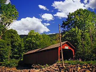
The Sonestown Covered Bridge is a covered bridge over Muncy Creek in Davidson Township, Sullivan County, Pennsylvania built around 1850. It is 110 ft (34 m) long and was placed on the National Register of Historic Places (NRHP) in 1980. It is named for the nearby unincorporated village of Sonestown in Davidson Township, and is also known as the Davidson Covered Bridge. It was built to provide access to a grist mill which operated until the early 20th century.

Lycoming Mall was a shopping mall located twelve miles east of Williamsport, Pennsylvania off Route 220 and I-180. It is anchored by Burlington.


