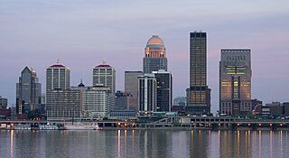
Louisville is the largest city in the Commonwealth of Kentucky, sixth-most populous city in the Southeast, and the 28th most-populous city in the United States. Louisville is the historical seat and, since 2003, the nominal seat of Jefferson County, on the Indiana border.

Trimble County is a county located in the north central part of the U.S. state of Kentucky. Its county seat is Bedford. The county was founded in 1837 and is named for Robert Trimble. Trimble is no longer a prohibition or dry county. Trimble County is part of the Louisville/Jefferson County, KY–IN Metropolitan Statistical Area.

Morgan County is a county located in the U.S. state of Kentucky. As of the 2020 census, the population was 13,726. Its county seat is West Liberty. The county is among the dry counties, which means that the sale of alcohol is restricted or prohibited.

Johnson County is a county located in the U.S. state of Kentucky. As of the 2020 census, the population was 22,680. Its county seat is Paintsville. The county was formed in 1843 and named for Richard Mentor Johnson, War of 1812 general, United States Representative, Senator, and Vice President of the United States. Johnson County is classified as a moist county, which is a county in which alcohol sales are not allowed, but containing a "wet" city, in this case Paintsville, where alcoholic beverage sales are allowed.

Hopkins County is a county located in the western part of the U.S. state of Kentucky. As of the 2020 census, the population was 45,423. Its county seat is Madisonville. Hopkins County was created December 9, 1806 from Henderson County. It was named for General Samuel Hopkins, an officer in both the American Revolutionary War and War of 1812, and later a Kentucky legislator and U.S. Congressman.

Greenup County is a county located along the Ohio River in the northeastern part of the U.S. state of Kentucky. As of the 2020 census, the population was 35,962. The county was founded in 1803 and named in honor of Christopher Greenup. Its county seat is Greenup. Greenup County is part of the Huntington-Ashland, WV-KY-OH Metropolitan Statistical Area.

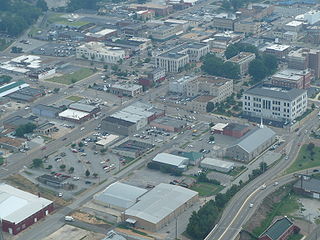
Harrisburg is a city in and the county seat of Saline County, Illinois, United States. It is located about 57 miles southwest of Evansville, Indiana, and 111 mi (179 km) southeast of St. Louis, Missouri. Its 2020 population was 8,219, and the surrounding Harrisburg Township had a population of 10,037, including the city residents. Harrisburg is included in the Illinois–Indiana–Kentucky tri-state area and is the principal city in the Harrisburg micropolitan statistical area with a combined population of 24,913.

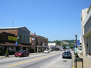
Morgantown is a home rule-class city in, and the seat of Butler County, Kentucky, United States. The population was 2,471 at the time of the 2020 Census.
Murray is a home rule-class city in Calloway County, Kentucky, United States. It is the seat of Calloway County and the 19th-largest city in Kentucky. The city's population was 17,741 during the 2010 U.S. census, and its micropolitan area's population is 37,191. Murray is a college town and is the home of Murray State University.

Vanceburg is a home rule-class city in Lewis County, Kentucky, United States, along the Ohio River. The population was 1,428 at the 2020 census. It is the county seat of Lewis County.

Maysville is a home rule-class city in Mason County, Kentucky, United States, and is the seat of Mason County. The population was 8,873 as of the 2020 census. Maysville is on the Ohio River, 66 miles (106 km) northeast of Lexington. It is the principal city of the Maysville Micropolitan Statistical Area, which comprises Mason County. Two bridges cross the Ohio from Maysville to Aberdeen, Ohio: the Simon Kenton Memorial Bridge built in 1931 and the William H. Harsha Bridge built in 2001.
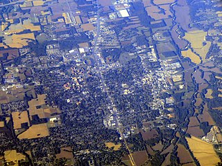
West Liberty is a home rule-class city in Morgan County, Kentucky, United States. It is the county seat of Morgan County. As of the 2020 census, the city population was 3,215. It is located along the Licking River at the junction of Kentucky Route 7 and U.S. Route 460.
Jackson is a city in and the county seat of Madison County, Tennessee, United States. Located 70 miles (110 km) east of Memphis, it is a regional center of trade for West Tennessee. Its total population was 68,205 as of the 2020 United States census. Jackson is the primary city of the Jackson, Tennessee metropolitan area, which is included in the Jackson-Humboldt, Tennessee combined statistical area. Jackson is Madison County's largest city, and the second-largest city in West Tennessee next to Memphis. It is home to the Tennessee Supreme Court's courthouse for West Tennessee, as Jackson was the major city in the west when the court was established in 1834.

John Hunt Morgan was an American soldier who served as a Confederate general in the American Civil War of 1861–1865.

Otter Creek Outdoor Recreation Area is a 2,600 acre (11 km²) riverfront park in Meade County, Kentucky. The park is located near Muldraugh and Fort Knox, along State Highway 1638, near U.S. 31W. Although it is located outside Louisville, the park was long operated by the city of Louisville and, after the 2003 merger of the city and Jefferson County, Louisville Metro Government. Both entities attempted to give or sell the park to Meade County and the Commonwealth of Kentucky at various times over the years, most recently in 2004. The park closed in 2009 and reopened in 2011. It is now operated by the Kentucky Department of Fish and Wildlife Resources.

The Chesapeake and Ohio Railway was a Class I railroad formed in 1869 in Virginia from several smaller Virginia railroads begun in the 19th century. Led by industrialist Collis P. Huntington, it reached from Virginia's capital city of Richmond to the Ohio River by 1873, where the railroad town of Huntington, West Virginia, was named for him.

Morgan's Raid was a diversionary incursion by Confederate cavalry into the Union states of Indiana, Kentucky, Ohio, and West Virginia during the American Civil War. The raid took place from June 11 to July 26, 1863. It is named for the commander of the Confederate troops, Brigadier General John Hunt Morgan. Although it caused temporary alarm in the North, the raid was ultimately classed as a failure.
The Huntington–Ashland metropolitan area is a metropolitan area in the Appalachian Plateau region of the United States. Referred to locally as the “Tri-State area”, and colloquially as "Kyova", the region spans seven counties in the three states of Kentucky, Ohio, and West Virginia. With a population of 361,580, the Tri-State area is nestled along the banks of the Ohio River. The region offers a diverse range of outdoor activities.
Stacy Fork is an unincorporated community in Morgan County, Kentucky, United States. It lies along Route 191 south of the city of West Liberty, the county seat of Morgan County. Its elevation is 823 feet (251 m).

Kentucky Route 191 (KY 191) is a 31.1-mile-long (50.1 km) state highway in the U.S. state of Kentucky. The highway connects Campton and West Liberty with mostly rural areas of Wolfe and Morgan counties.


