
Frankfort is the capital city of the U.S. state of Kentucky and the seat of Franklin County. It is a home rule-class city. The population was 28,602 at the 2020 United States census. Located along the Kentucky River, Frankfort is the principal city of the Frankfort, Kentucky Micropolitan Statistical Area, which includes all of Franklin and Anderson counties. It is the 4th least populous state capital in the United States, and the 13th most populous city in Kentucky.

Trimble County is a county located in the north central part of the U.S. state of Kentucky. Its county seat is Bedford. The county was founded in 1837 and is named for Robert Trimble. Trimble is no longer a prohibition or dry county. Trimble County is part of the Louisville/Jefferson County, KY–IN Metropolitan Statistical Area.

Paris is a home rule-class city in Bourbon County, Kentucky the county seat. It lies 18 miles (29 km) northeast of Lexington on the Stoner Fork of the Licking River. It is part of the Lexington–Fayette Metropolitan Statistical Area. As of 2020, it had a population of 10,171.

Munising Township is a civil township of Alger County in the U.S. state of Michigan. As of 2020, its population was 2,865.

Morgan's Raid was a diversionary incursion by Confederate cavalry into the Union states of Indiana, Kentucky, Ohio, and West Virginia during the American Civil War. The raid took place from June 11 to July 26, 1863. It is named for the commander of the Confederate troops, Brigadier General John Hunt Morgan. Although it caused temporary alarm in the North, the raid failed.

Unger is an unincorporated community in southern Morgan County in the U.S. state of West Virginia. Unger is distinguished amongst other towns in Morgan County for retaining an operating post office since one was established there in 1853. From 1857 to 1935, it was known as Unger's Store until March 31, 1950 its name was then shortened to Unger on April 1, 1950.
Highsplint is a former coal town with an extinct post office in Harlan County, Kentucky, United States. It was named for the High Splint and Seagraves Coal Companies which operated a mine in the town at that time. Highsplint's first post office was established on February 7, 1918, with John D. Casey as postmaster, remaining in operation until 1974.
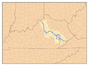
Ezel is an unincorporated community and census-designated place (CDP) in Morgan County, Kentucky, United States. As of the 2020 census, it had a population of 209. It has a small post office, with the ZIP code 41425.
Relief is an unincorporated community in Morgan County, Kentucky, United States. It lies along Route 172 east of the city of West Liberty, the county seat of Morgan County. Its elevation is 732 feet (223 m).
Dingus is an unincorporated community in Morgan County, Kentucky on Kentucky Highway 437, between Elamton and Mima. The town is located 14 miles from West Liberty, the county seat. There was formerly a post office in the town, but residents are now served by the post office at Elkfork, Kentucky (41421). Dingus lies at an elevation of 883 feet.
Proctor is an unincorporated community in Lee County, Kentucky, United States. It lies along Route 11 on the other side of the river from Beattyville south of the city of Beattyville, the county seat of Lee County. Proctor is also located near the beginning point of the Kentucky River. There are three tributaries which combine near Beattyville and Proctor; the North Fork of the Kentucky River, the Middle Fork of the Kentucky River; and the South Fork of the Kentucky River. For this reason, many local businesses make mention of the "Three Forks".
Neatsville is an unincorporated community in Adair County, in the U.S. state of Kentucky. It is located at the junction of Kentucky Route 206 and Kentucky Route 76. Its elevation is 705 feet (215 m). For unknown reasons, the town's name was spelled as Neetsville from 1876 until 1886, when the town's post office closed. In its early history from around the 1810s to 1900, Neatsville progressively grew to become a well-established, incorporated town. It has been relocated twice through the years, once due to flooding circa 1900–1902, which decimated the town, and once in the 1960s when the Green River was impounded to make way for the Green River Reservoir.
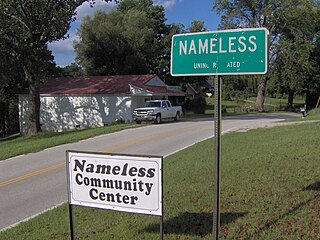
Nameless is an unincorporated community in Jackson County, Tennessee, United States.
Malden is an unincorporated community in Morgan Township, Porter County, in the U.S. state of Indiana. The town is locally well known for its Labor Day parade, usually having a large turn-out despite the town's small size.
Spyrock is an unincorporated community of ranches in Mendocino County, California. It is located around Spyrock Road, which runs east of Highway 101 to the Eel River and Northwestern Pacific Railroad.
The 1899 Kentucky gubernatorial election was held on November 7, 1899, to choose the 33rd governor of Kentucky. The incumbent, Republican William O'Connell Bradley, was term-limited and unable to seek re-election.
Laurel Creek is a creek that is a tributary of Goose Creek river in Clay County, Kentucky. It is 7.5 miles (12.1 km) long. The name comes from the proliferation of mountain laurel on its riverbanks.
Addison is an unincorporated community in Breckinridge County, Kentucky, United States. Addison is located on the Ohio River and Kentucky Route 144, 6.8 miles (10.9 km) north-northeast of Cloverport.

Twin Buttes is a populated place on the east flank of the Sierrita Mountains approximately twenty miles south of Tucson, in Pima County, Arizona, United States. Named after a prominent hill located next to the town, Twin Buttes was founded as a small mining town circa 1903 and abandoned around 1930. Much of the actual town site is now buried underneath mine tailings, and all that remains is the Twin Buttes Cemetery.


