Canterbury-Bankstown

Last updated

Canterbury-Bankstown
New South Wales
Bankstown CBD Aerial view.jpg
Bankstown is the civic and commercial hub of Canterbury-Bankstown
LGA(s) Canterbury-Bankstown
State electorate(s)
Federal division(s)

Canterbury-Bankstown is a customary region of Sydney, Australia, in Inner South-Western Sydney. The region is located to the north of the St George region (from which it is separated by Wolli Creek) and to the south of the Inner West region (from which it is separated by the Cooks River). The suburbs of the Canterbury-Bankstown region are not specific to the local government area of the City of Canterbury-Bankstown, but includes many of them. The Bankstown railway line serves many of the suburbs in this region.

Contents

History

The original inhabitants of Canterbury and Bankstown were the Gweagal, Bidjigal, (also known as Bediagal) and a small portion of the Dharug people.

Five years after the first fleet arrived in Sydney Cove in 1788, a man by the name of Rev Richard Johnson, a chaplain aboard the First Fleet, was the first to receive a land grant of 40 hectares in what is now known as the 'Canterbury–Bankstown region'. The land was located in the Ashbury-Hurlstone Park area. He named his estate 'Canterbury Vale', presumably after the See of Canterbury in England. The date of the grant was May 1793 although he (Johnson) occupied the land months earlier. Johnson also cultivated land around his cottage in Bridge St Sydney and at another location called the Brickfield near Central Station. Johnson was praised by Watkin Tench as being one of the best farmers in the colony. [1] :4,6,81

The first ambulance to service the area was in 1908. It was called the 'Canterbury District Ambulance Corps' and it used volunteers to transport patients to the hospital. A stretcher on wheels with a hooded cover over it (hand litter) was used to transport patients to the Western Suburbs Hospital. If a patient lived in an area around Belmore, the hand litter was transported by train from Campsie to Belmore, then it was pushed along the rough unsealed roads to the patients home, back to Belmore station, then taken by train to Campsie Station and along the streets to hospital.[ citation needed ]

The Canterbury District Memorial Hospital commenced business on 26 October 1929. The hospital was opened by Secretary for Public Works Buttenshaw. Prior to the opening of the hospital [in Canterbury], residents attended the Western Suburbs Hospital or the cottage hospital located in Marrickville, which was established in 1895.[ citation needed ]

In 1940, the events of World War II were made known to the residents of Canterbury-Bankstown. Men and women who were drafted had to report for duty at a drill hall located on Canterbury Road Belmore. Camps were set up in Canterbury Race Course and surrounding parks in the region. In that same year thousands of Australian troops travelled along the goods line to Darling Harbour, ready to embark for the Middle East.

Australia's air defence headquarters during WW2, Bankstown Bunker, also known as No. 1 Fighter Sector RAAF BANKSTOWN BUNKER DURING WWII.jpg
Australia's air defence headquarters during WW2, Bankstown Bunker, also known as No. 1 Fighter Sector RAAF

In 1940 the department of Civil Aviation purchased 250 hectares of land in Bankstown for the construction of Bankstown Airport and an RAAF Station was formed. The facility was a secondary airport to Mascot Airport. In 1942 a command bunker (Sydney Air Defence Headquarters) of semi underground construction was established on the corner of Edgar and Marion Street Bankstown. The bunker was manned by No. 1 Fighter Sector RAAF, members of the No.2 Volunteer Air Observer Corps, the WAAAF's, the RAAF and the United States Army Air Forces. The primary use of the Sydney Air Defence Headquarters was the location, tracking and interception of all planes in the eastern area of the South West Pacific. [2] [1] :89

In 1941, WAAAF's were posted to Bankstown. The women were trained as clerks, wireless telegraphists, mess orderlies, drill instructors and drivers, a portion of these women were assigned to work in the command centre (Bankstown Bunker) located on Black Charlies Hill. In 1942, Belmore House, the current sight of today's Roselands Shopping Centre was used by the Australian Army for the training of troops. Tents on the property were used to house an infantry battalion and an ambulance corps. The site was vacated after a year. Units of the US Air Force were based in Bankstown after 1942, earning the suburb the nickname 'Yankstown'. Also in 1942 a military hospital was established for the U.S. Army at Herne Bay, now known as Riverwood. It was the largest military hospital in Australia during World War II. Known as the 118 General Hospital it consisted of 490 timber barracks-type buildings, which could house a total of 4,250 beds and accommodate up to 1,250 patients and 3,500 staff. [1] :94

Within the same year 16 US fighter planes that were based at Bankstown airport flew over Canterbury racecourse at low altitude during a race meet. This was to let the Australian public, especially those of the district to know that they, their allies were there for their protection. Regardless of these events, punters were annoyed at the disruption caused.

From 1944 to 1945, a Volunteer Air Observer Corps operated in Bankstown. These volunteers were both male and female, were of 15 to 60 years of age and were given several weeks training. There were over 300 volunteers who worked in shifts that the air force called 'flights' 24 hours a day, seven days a week. This freed RAAF personnel for other duties. In 1945 Bankstown Airport was occupied by the British Fleet Air Arm, known as HMS Nabberley, and the RAAF by 1946. [2] [1] :88,90,91–94

Suburbs

The Canterbury-Bankstown region is not an exact area, although the following suburbs are usually agreed to be a part of the region:

Residents

Residential housing in Punchbowl A street in punchy.jpg
Residential housing in Punchbowl
Large natural parklands in the south of the region, around Salt Pan Creek Saltpancreekswamp.jpg
Large natural parklands in the south of the region, around Salt Pan Creek

The Canterbury-Bankstown region is characterised by high-density housing towards the east and larger family homes towards the west with large natural parklands toward the south, such as those around Salt Pan Creek. Suburbs within the region have a multicultural nature.

Young families and couples are opting to live in the Canterbury-Bankstown region as a cheaper alternative to living in Sydney's Inner West[ citation needed ], while at the same time residents of the region are suffering heavily from mortgage repossession which is forcing poorer families to move into Sydney's Outer Western Suburbs.[ citation needed ]

Like Sydney's inner west, Canterbury-Bankstown is multi-cultural. There is a significant Chinese, Indian, Korean, Fijian, Vietnamese, Lebanese, Greek, Italian, Yugoslav and African population. This is also reflected in the variety and style of many local businesses and cultural institutions.

Notable former residents include the former Prime Minister John Howard [3] and Paul Keating [4] and Olympian Ian Thorpe. [5]

The Australian Bureau of Statistics defines two statistical areas (SAL3) called "Canterbury" and "Bankstown" respectively, which together largely correlate with the customary definitions of the Canterbury–Bankstown region. Based on the 2021 Australian census:

Government

The Canterbury-Bankstown region is mostly governed by the City of Canterbury-Bankstown, a local government authority in Sydney. [8]

The federal divisions of Barton, Banks, Blaxland, Grayndler and Watson are located within part or all of the region of Canterbury-Bankstown. The state electoral districts of Bankstown, Canterbury, East Hills and Lakemba are located within part or all of the region. It is a relatively safe region for the Labor party.

Economy

Multinational companies such as Volkswagen and Cosentino have based Australian operations in the region. There is also major investment by local and foreign companies in the aviation, print media and retail.

Commercial areas

Bankstown Central is the largest shopping centre in Canterbury-Bankstown Centro Bankstown 2008 redevelopment.jpg
Bankstown Central is the largest shopping centre in Canterbury-Bankstown

The biggest commercial areas in the Canterbury-Bankstown area are located at Bankstown, Campsie and Roselands. Bankstown is the largest central business district in the region and features a large shopping centre called Bankstown Central. Roselands also features a large shopping centre called Roselands Shopping Centre. The Canterbury–Bankstown region also has a variety of Vietnamese, Lebanese, Greek, Italian, Spanish, African and Australian restaurants, delicatessens, sweet shops, grocery and fresh food markets.

Transport

Bankstown railway station Bankstown railway station 20180929 01.jpg
Bankstown railway station

Canterbury, Liverpool and Punchbowl Roads are the main roads through the area. The M5 Motorway runs through the Bankstown are and close to the southern boundary of the Canterbury area, and provides a motorway connection from this region east to Sydney Airport and west to Liverpool and beyond and (via the M8 Motorway and WestConnex) the Inner West region and beyond.

Public transport in the region includes trains and buses. Sydney Trains's Bankstown Line runs from the City Circle to Liverpool or Lidcombe via Campsie and Bankstown. The Airport & South Line also runs from the City Circle and follows a more southerly route, with all stations services that terminate at Revesby and limited stops services which continue onto Macarthur. This line also provides a direct connection from the region to Sydney Airport. There are various bus routes provided largely by the privately owned companies Transit Systems and U-Go Mobility.

Education

The Canterbury-Bankstown region is home to the Bankstown Campus of Western Sydney University.

Health

The former City of Canterbury is served by the Sydney Local Health District of NSW Health, which also covers the Inner West region. Canterbury Hospital, a historic public hospital operated by the Sydney Local Health District is in the region. [9] The former City of Bankstown is served by the South Western Sydney Health District of NSW Health, which also covers an expansive area to the south and west of Sydney as far south as the Southern Highlands. [10]

Notable organisations

Related Research Articles

<span class="mw-page-title-main">Canterbury-Bankstown Bulldogs</span> Australian rugby league club

The Canterbury-Bankstown Bulldogs are an Australian professional rugby league club based in Belmore, a suburb in the Canterbury-Bankstown region of Sydney. They compete in the NRL Telstra Premiership, as well as competitions facilitated by the New South Wales Rugby League, including the Canterbury Cup NSW, the Jersey Flegg Cup, Harvey Norman Women's Premiership, Tarsha Gale Cup, S. G. Ball Cup and the Harold Matthews Cup.

<span class="mw-page-title-main">Bankstown</span> Suburb of Sydney, New South Wales, Australia

Bankstown is a suburb of Sydney, in the state of New South Wales, Australia. It is located 19 kilometres south-west of the Sydney central business district and is part of the Canterbury-Bankstown region. Bankstown is the administrative centre of the City of Canterbury-Bankstown, having previously been the administrative centre of the City of Bankstown prior to the 2016. It is the most populous suburb within the City of Canterbury-Bankstown.

<span class="mw-page-title-main">Inner West</span> Region in New South Wales, Australia

The Inner West of Sydney is an area directly west of the Sydney central business district, New South Wales, Australia. The suburbs that make up the Inner West are predominantly located along the southern shore of Port Jackson, stretching south to the shores of the Cooks River. The western boundary of the Inner West is approximately the A3 arterial road, which divides the Inner West from the Greater Western Sydney region. The Inner West is much larger than the Inner West Council local government area. The Inner West roughly corresponds with the Parish of Petersham and Parish of Concord, two cadastral divisions used for land titles.

<span class="mw-page-title-main">Lakemba, New South Wales</span> Suburb of City of Canterbury-Bankstown, New South Wales, Australia

Lakemba is a suburb in Western Sydney, in the state of New South Wales, Australia. Lakemba is located 12 kilometres south west of the Sydney central business district, in the local government area of the City of Canterbury-Bankstown.

Riverwood is a suburb in southern Sydney, in the state of New South Wales, Australia. Riverwood is located 19 kilometres south of the Sydney central business district and is part of the St George area. Riverwood is split between the local government areas of the Georges River Council and the City of Canterbury-Bankstown.

<span class="mw-page-title-main">Division of Watson</span> Australian federal electoral division

The Division of Watson is an Australian electoral division in the state of New South Wales.

<span class="mw-page-title-main">Roselands, New South Wales</span> Suburb of Sydney, New South Wales, Australia

Roselands is a suburb to the south-west of the Sydney CBD, in the state of New South Wales, Australia. Roselands is located 16 kilometres south-west of the Sydney central business district in the City of Canterbury-Bankstown. It is one of the easternmost suburbs in the Western Sydney area and is one of the major suburbs in Sydney without a train station.

<span class="mw-page-title-main">Kingsgrove</span> Suburb of Sydney, New South Wales, Australia

Kingsgrove is a suburb in Southern Sydney, New South Wales, Australia. Kingsgrove is 13 kilometres (8.1 mi) south-west of the Sydney central business district and lies across the local government areas of the City of Canterbury-Bankstown, Bayside Council and the Georges River Council.

<span class="mw-page-title-main">Condell Park</span> Suburb of Sydney, New South Wales, Australia

Condell Park, a suburb of local government area City of Canterbury-Bankstown, is 21 kilometres south-west of the Sydney central business district, in the state of New South Wales, Australia. It is a part of the Canterbury Bankstown region, and within the Inner South West area categorised by the Australian Bureau of Statistics. The postcode of Condell Park is 2200, which is shared with Bankstown and Bankstown Aerodrome.

<span class="mw-page-title-main">Campsie, New South Wales</span> Suburb of Sydney, New South Wales, Australia

Campsie is a suburb in the state of New South Wales, Australia. Campsie is 11 kilometres south west of the Sydney central business district, on the southern bank of the Cooks River. Campsie is one of the administrative centres of the City of Canterbury-Bankstown.

<span class="mw-page-title-main">Earlwood, New South Wales</span> Suburb of Sydney, New South Wales, Australia

Earlwood is a suburb of Western Sydney, in the state of New South Wales, Australia. Earlwood is located 10 kilometres south-west of the Sydney central business district, and is part of the Canterbury-Bankstown area. It is in the local government area of the City of Canterbury-Bankstown.

<span class="mw-page-title-main">Belfield, New South Wales</span> Suburb of Sydney, New South Wales, Australia

Belfield is a suburb of Sydney, in the state of New South Wales, Australia. It is 13 kilometres southwest of the Sydney central business district, in the local government area of the City of Canterbury-Bankstown.\

<span class="mw-page-title-main">Belmore, New South Wales</span> Suburb of Sydney, New South Wales, Australia

Belmore is a suburb of Sydney, in the state of New South Wales, Australia. Belmore is located 11 kilometres south-west of the Sydney central business district, in the local government area of the City of Canterbury-Bankstown.

<span class="mw-page-title-main">Clemton Park, New South Wales</span> Suburb of Sydney, New South Wales, Australia

Clemton Park is a suburb in south-western Sydney, in the state of New South Wales, Australia. It is 13 kilometres south-west of the Sydney central business district in the City of Canterbury-Bankstown. The suburb is approximately bounded by Cup and Saucer Creek, Bexley Road in the east, William Street in the south and Kingsgrove Road, but excludes most of the properties which face onto those roads. Those properties are instead in the neighbouring suburbs of Earlwood, Kingsgrove and Campsie.

<span class="mw-page-title-main">Croydon Park, New South Wales</span> Suburb of Sydney, New South Wales, Australia

Croydon Park is a suburb in the Inner West of Sydney, in the state of New South Wales, Australia. Croydon Park is 10 kilometres south-west of the Sydney central business district and is divided between the local government areas of the City of Canterbury-Bankstown, Municipality of Burwood and Inner West Council. Croydon is a separate suburb, to the north.

<span class="mw-page-title-main">Punchbowl Bus Company</span>

Punchbowl Bus Company (PBC) is an Australian bus company. It operates bus services in Goulburn and Crookwell in the Southern Tablelands as PBC Goulburn and PBC Crookwell.

<span class="mw-page-title-main">Regions of Sydney</span> Overview article

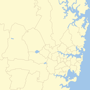
The metropolis of Greater Sydney in New South Wales, Australia, is informally subdivided into a number of geographic regions. The geographical definition of Greater Sydney spans across 33 local government areas and includes the Blue Mountains in the west, the Northern Beaches and the Hawkesbury in the north, the Royal National Park, the Wollondilly and Macarthur in the south, and Botany Bay in the east. These areas sometimes, but not always, roughly coincide with official boundaries of suburbs, local government authorities, or cadastral units, and some of the customary regions do not have well defined boundaries at all. Some commonly referred to regions overlap: for example, Canterbury-Bankstown is often referred to as a region, but it is also part of the South Western Sydney region. The regions themselves are not used as a formal jurisdiction, and generally do not have administrative or legislative bodies, although some regions are coterminous with a local government area, and in a number of regions that include multiple local government areas, Regional Organisations of Councils have been established that represent the councils in the region.

Sydney, Australia is served by a number of bus operators, with Transit systems the largest privately owned operator in New South Wales as of January 2024 when the company took-over Transdev Liverpool, Busabout and Interline. Other major operators include CDC and Busways. Most services are provided as part of the city's integrated public transport system, with routes, fares, service levels, fleet specifications and customer service standards determined by Transport for NSW. A small number of services operate outside of this network.

Highway Tours was an Australian bus company operating services in the south-western suburbs of Sydney, New South Wales.

<span class="mw-page-title-main">City of Canterbury-Bankstown</span> Local government area in New South Wales, Australia

Canterbury-Bankstown Council, trading as the City of Canterbury Bankstown, is a local government area in the Canterbury-Bankstown region of Sydney, New South Wales, Australia. The council was formed on 12 May 2016 from a merger of the City of Canterbury and the City of Bankstown, after a review of local government areas by the NSW Government.

References

  1. 1 2 3 4 Lawrence, Joan; Madden, Brian; Muir, Lesley (1999). A Pictorial History of Canterbury Bankstown. Alexandria: Kingsclear Books. ISBN   978-0-908272-55-6.
  2. 1 2 Drucker, G. "Index of Fleet Air Arm Air Stations in the Commonwealth 1939–1945". Fleetairarmarchive.net. Archived from the original on 19 September 2008. Retrieved 23 November 2013.{{cite web}}: CS1 maint: unfit URL (link)
  3. "Australia Religious Right God Under Howard John Howard Marion Maddox Methodist Earlwood Family First". www.methodist.org.nz. Archived from the original on 31 March 2008.
  4. "Wealth Creator Magazine – Paul Keating: From Bankstown to the Top". www.wealthcreator.com.au. Archived from the original on 29 August 2007.
  5. "Sydney City Guide – Bankstown". Angelfire.com. 12 January 2007. Retrieved 23 November 2013.
  6. ABS, Quickstats (2021) – Canterbury SAL3
  7. ABS, Quickstats (2021) – Bankstown SAL3
  8. "Canterbury-Bankstown Council". Stronger Councils. Government of New South Wales. 12 May 2016. Retrieved 14 May 2016.
  9. SLHD – Hospitals
  10. South Western Sydney Health District
  11. http://theexpress.com.au/