
Voyager Point is a small suburb, in South Western Sydney in the state of New South Wales, Australia. Voyager Point is located 25 kilometres south of the Sydney central business district, in the local government area of the City of Liverpool. The only adjacent suburbs are Sandy Point, Holsworthy and Pleasure Point. Milperra, Panania and East Hills are located on the opposite bank of the Georges River. In the 2016 census, Voyager Point recorded a population of 1668 people.

Georges Hall, a suburb of local government area City of Canterbury-Bankstown, is located 24 kilometres south-west of the Sydney central business district in the state of New South Wales, Australia, and is part of the South-western Sydney region.
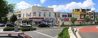
Bankstown is a suburb south west of Sydney, in the state of New South Wales, Australia. It is 19 kilometres south-west of the Sydney central business district and is located in the local government area of the City of Canterbury-Bankstown, having previously been the administrative centre of the City of Bankstown prior to 2016. It is the most populous suburb within the City of Canterbury-Bankstown.

Hurlstone Park is a suburb in the Inner West of Sydney, New South Wales, Australia. Hurlstone Park is located nine kilometres south-west of the Sydney central business district and is mostly in the local government area of the City of Canterbury-Bankstown, and partly in the Inner West Council. The suburb is bounded by: the Cooks River to the south, Garnet Street to the east, New Canterbury Road to the north, Canterbury Road to the north-west, and Church Street to the west.

Padstow, a suburb of local government area City of Canterbury-Bankstown, is located 21 kilometres south-west of the Sydney central business district, in the state of New South Wales, Australia, and is a part of the South-western Sydney region. Padstow is a mostly residential suburb bounded on the north by Bankstown and on the east by Salt Pan Creek, which is a stream feeding into the Georges River. The M5 South Western Motorway traverses the northern end of the suburb, which is also the location of a number of light industrial facilities.

Panania, a suburb of local government area City of Canterbury-Bankstown, is located 23 kilometres inner south-west of the Sydney central business district, in the state of New South Wales, Australia, and is a part of the South-western Sydney region. The postcode is 2213, which it shares with adjacent suburbs East Hills and Picnic Point.

Canterbury is a suburb of south-western Sydney, in the state of New South Wales, Australia. Canterbury is located 10.5 kilometres (6.5 mi) south-west of the Sydney central business district in the City of Canterbury-Bankstown.

Bass Hill, a suburb of local government area City of Canterbury-Bankstown, is located 23 kilometres south-west of the Sydney central business district, in the state of New South Wales, Australia, and is a part of the South-western Sydney region.

Revesby, a suburb of local government area City of Canterbury-Bankstown, is located 22 kilometres south-west of the Sydney central business district, in the state of New South Wales, Australia, and is a part of the South-western Sydney region.

Wiley Park is a suburb in south-western Sydney, in the state of New South Wales, Australia. Wiley Park is located 17 kilometres south-west of the Sydney central business district in the City of Canterbury-Bankstown.
Picnic Point, a suburb of local government area City of Canterbury-Bankstown, is 23 kilometres south-west of the Sydney central business district, in the state of New South Wales, Australia. It is a part of South-western Sydney region. Picnic Point is a residential suburb on the northern bank of the Georges River. Located within Picnic Point is Yeramba Lagoon which is the largest tract of National Park within the Canterbury – Bankstown Council, it is home to numerous species of native fauna and flora.

Narwee is a suburb in southern Sydney, in the state of New South Wales, Australia. Narwee is located 18 kilometres south of the Sydney central business district and is part of the St George area. Narwee is in local government areas of City of Canterbury-Bankstown and Georges River Council. The postcode is 2209, which it shares with neighbouring Beverly Hills.

Moorebank is a suburb of Sydney, in the state of New South Wales, Australia. Moorebank is located 27 kilometres south-west of the Sydney central business district in the local government area of the City of Liverpool.

Kingsgrove is a suburb in Southern Sydney, New South Wales, Australia. Kingsgrove is 13 kilometres (8.1 mi) south-west of the Sydney central business district and lies across the local government areas of the City of Canterbury-Bankstown, Bayside Council and the Georges River Council.

East Hills, a suburb of local government area City of Canterbury-Bankstown, is located 26 kilometres south-west of the Sydney central business district, in the state of New South Wales, Australia, and is a part of the South-western Sydney region, near larger areas like Revesby and Bankstown.

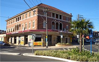
Campsie is a suburb in the state of New South Wales, Australia. Campsie is 11 kilometres south west of the Sydney central business district, on the southern bank of the Cooks River. Campsie is one of the administrative centres of the City of Canterbury-Bankstown.
Earlwood is a suburb of Sydney, in the state of New South Wales, Australia. Earlwood is located 10 kilometres south-west of the Sydney central business district, and is part of the Canterbury-Bankstown area. It is in the local government area of the City of Canterbury-Bankstown.

Garrison Point is a promontory and historically significant urban park located near the junction of Georges River and Prospect Creek. The parkland may be accessed off Henry Lawson Drive, in the south-western Sydney suburb of Georges Hall, in the City of Canterbury-Bankstown local government area of New South Wales, Australia.

Lansdowne is a suburb in south-western Sydney, in the state of New South Wales, Australia. Lansdowne is located 27 kilometres west of the Sydney central business district, in the local government area of the City of Canterbury-Bankstown and is part of the South-western Sydney region. Its western boundary is Prospect Creek, the north the Hume Highway and the east and south Georges Hall.
Milperra Bridge is a road bridge that carries Newbridge Road across the Georges River, located between Bankstown and Liverpool, in South Western Sydney, New South Wales, Australia. The bridge is located adjacent to Henry Lawson Drive and the Bankstown Airport; and Newbridge Road serves as a continuation of Canterbury and Milperra Roads.


