Georges River

Last updated
Georges River
Tucoerah River [1]
PortHacking-Sydney-Ria.jpg
Georges River, looking towards its mouth at Botany Bay, and out to the Tasman Sea .
Sydney AST2001oct12 lrg.jpg
Red pog.svg
NASA satellite view of Greater Metropolitan Sydney, with the location of the mouth of the Georges River, as marked
EtymologyIn honour of King George III [2]
Location
Country Australia
State New South Wales
Region Greater Metropolitan Sydney
LGAs Bayside, Campbelltown, Canterbury-Bankstown, Fairfield, Georges River, Liverpool, Sutherland, Wollondilly
Physical characteristics
SourceUpland swamps, O'Hares Creek
  locationeast of Appin in Macarthur
  coordinates 34°15′00″S150°49′48″E / 34.25000°S 150.83000°E / -34.25000; 150.83000
  elevation350 m (1,150 ft)
Mouth Botany Bay
  location
Taren Point/San Souci
  coordinates
34°0′35.994″S151°7′47.6394″E / 34.00999833°S 151.129899833°E / -34.00999833; 151.129899833
Length96 km (60 mi)
Basin size930.9 km2 (359.4 sq mi)
Basin features
Tributaries 
  leftBunbury Curran Creek, Cabramatta Creek, Lennox River (proposed), Prospect Creek, Salt Pan Creek, Boggywell Creek
Lakes and reservoirs Chipping Norton Lakes
[3] [4]

The Georges River, also known as Tucoerah River, [1] is an intermediate tide-dominated drowned valley estuary, [5] that is located in Sydney in the state of New South Wales, Australia. The Georges River is located south and south-west from the Sydney CBD, with the mouth of the river being at Botany Bay.

Contents

The river travels for approximately 96 kilometres (60 mi) in a north and then easterly direction to its mouth at Botany Bay, about 5 kilometres (3.1 mi) from the Tasman Sea. The Georges River is the main tributary of Botany Bay; with the Cooks River being a secondary tributary.

The total catchment area of the river is approximately 930.9 square kilometres (359.4 sq mi) and the area surrounding the river is managed by various local government authorities and NSW Government agencies across Sydney.

The land adjacent to the Georges River was occupied for many thousands of years by the Tharawal and Eora peoples. They used the river as an important source of food and a place for trade.

Geography

Freres Crossing, near Campbelltown. Frerres Crossing (1).JPG
Freres Crossing, near Campbelltown.

From its source east of Appin within heath habitat of Wollondilly Shire & Wollongong Local government area, the Georges River flows north through rugged sandstone gorges to the east of Campbelltown, roughly parallel to the Main South railway line, with its eastern bank forming a boundary of Holsworthy Army Base. At Glenfield it reaches the urban environment and then travels to Liverpool where the river turns east and flows past the suburbs of East Hills, Lugarno, and Blakehurst, before emptying into Botany Bay at Taren Point/Sansouci in the southern suburbs of Sydney, where it joins with the estuarine catchment.

Major tributaries include O'Hares Creek, Bunbury Curran Creek, Cabramatta Creek, Lennox River (proposed), Prospect Creek, Salt Pan Creek and the Woronora River. The Georges River is popular for recreational activities such as water skiing and swimming. The banks of the river along the lower reaches are marked by large inlets and indentations overlooked by steep sandstone ridges and scarps, many being home to expensive residential properties.

The Georges River features some artificial lakes in the suburb of Chipping Norton, near Liverpool. These lakes, known as the Chipping Norton Lakes, are the result of sand mining and quarrying operations in the twentieth century. The Lakes are now a popular watersports and recreational facility for the residents of the south-western suburbs of Sydney.

Liverpool Weir now forms the uppermost tidal limit and presence of salt water on the Georges River.

[From Appin to Glenfield, a large corridor has been protected as part of the Georges River Regional Open Space Corridor. Council reserves allow for access to natural sections of the river at Simmo's Beach, [6] Ingleburn Reserve, Keith Longhurst Reserve, [7] and Frere's Crossing. [8]

Botany Bay Community River Health Monitoring Program is a community-based initiative to monitor ecosystem health catchment. [9]

History

Aboriginal history

Prior to the arrival of Europeans, Georges River was formerly known as Tucoerah (or Toggerai / Tuggerah) River[ clarification needed ] by the traditional custodians of the area. It is not known whether this word referred to the whole river or rather just a part of it. Mill Creek, a tributary of Tucoerah was called Guragurang.

To the south of Tocoerah are the traditional lands of the Dharawal people. The Dharug/Eora people are the traditional custodians of the land on its northern banks.

European history

The Georges River was given its English name in honour of King George III, by Governor Arthur Phillip. [2] It was one of the many sites of the Hawkesbury and Nepean Wars, a series of wars between the Kingdom of Great Britain and the resisting Indigenous clans in the late 1700s and early 1800s. [10]

One of the earliest contacts between British settlers and Aboriginal people occurred on 20 January 1788. Arthur Philip and Philip Gidley King, leading a party of seamen from the First Fleet rowing two open boats, explored the 'South-West Arm of Botany Bay' (now Georges River). They are now thought to have gone as far as Lime Kiln Bay, where they landed at two locations there, the first of which they called 'Lance Point'—thought to be modern-day Gertrude Point, Lugarno—where an altercation with local people occurred. Later the same day, there was a peaceful meeting at what is now thought to have been the head of Lime Kiln Bay. They are also now believed to have entered the estuarine mouth of the Georges Rivers' tributary, Woronora River. Not finding enough freshwater, around Botany Bay and its two 'arms', the colonists moved on to Port Jackson, where the settlement of Sydney began six days later. [11] [12]

The river was explored by Bass and Flinders in 1795 on their first voyage on the Tom Thumb after their arrival in New South Wales. The exploration led to the establishment of Bankstown .

A dam was constructed by David Lennox using convict labour at Liverpool in 1836, as a water supply to Liverpool. [13]

In February 2007, Liverpool and Campbelltown City Council were awarded a $2 million grant from the NSW Environmental Trust under their Urban Sustainability Initiative. [14] The grant was to allow the councils, in conjunction with Wollondilly Shire Council and the Georges River Combined Councils Committee, to develop a Comprehensive Strategic Plan focused on the rehabilitation of the catchment area. [15]

Since the 2010s, the Mandaean community in the Greater Sydney region has been using the Georges River for their ritual baptisms, called masbuta . Along with the Nepean River, it is one of the few ritual rivers (called yardna in Mandaic) that they use for their baptism and ablution rituals. [16] [17] [18]

Crossings

Georges River from East Hills. Georges river easthills..jpg
Georges River from East Hills.
View of the river as it passes through East Hills and Voyager Point. The Voyager Point footbridge and the East Hills railway line bridge can be seen in the middle distance Aerial View of East Hills, 2004 (19772988019).png
View of the river as it passes through East Hills and Voyager Point. The Voyager Point footbridge and the East Hills railway line bridge can be seen in the middle distance

Bridges over the Georges River include from east to west:

Fish

Georges River from Illawong. Illawong 1.JPG
Georges River from Illawong.

The Georges River is a popular area for recreational fishing. Species present in the river include bass, bream, whiting, yellowtail, jewfish and flathead. The river is also host to a number of commercial oyster farms. The upper ends of the Georges River are abundant with Bass during the summer months and during the winter months these bass migrate down to the lower ends of the river towards the salt water to breed. Waste water inflows to the river are carefully managed to maintain the estuarine habitat.

See also

Related Research Articles

<span class="mw-page-title-main">Heathcote National Park</span> Protected area in New South Wales, Australia

Heathcote National Park is a protected national park that is located in the southern area of Sydney, New South Wales in eastern Australia, and is situated on Dharawal country. The 2,679-hectare (6,620-acre) national park is situated approximately 35 kilometres (22 mi) southwest of the Sydney central business district, west of the Illawarra railway line, the Princes Highway and Motorway, and the suburbs of Heathcote and Waterfall.

<span class="mw-page-title-main">Port Jackson</span> Body of water in Sydney, Australia

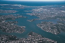
Port Jackson, consisting of the waters of Sydney Harbour, Middle Harbour, North Harbour and the Lane Cove and Parramatta Rivers, is the ria or natural harbour of Sydney, New South Wales, Australia. The harbour is an inlet of the Tasman Sea. It is the location of the Sydney Opera House and Sydney Harbour Bridge. The location of the first European settlement and colony on the Australian mainland, Port Jackson has continued to play a key role in the history and development of Sydney.

<span class="mw-page-title-main">Airport & South Line</span> Rail service in Sydney, New South Wales

The Airport & South Line is a suburban commuter rail line in Sydney, Australia. It connects the Sydney central business district with the southwestern suburbs via Sydney Airport. The line is part of the Sydney Trains network. The line began operating on 26 November 2017, when the T2 Airport, Inner West & South Line was split in two. Sydney Trains' predecessor CityRail operated the Airport & East Hills Line over an identical route between 2000 and 2013.

<span class="mw-page-title-main">Liverpool railway station, Sydney</span> Railway station in Sydney, New South Wales, Australia

Liverpool railway station is a heritage-listed railway station located on the Main Southern line, serving the Sydney suburb of Liverpool in Australia. It is served by Sydney Trains T2 Inner West & Leppington, T3 Bankstown and T5 Cumberland services. It was added to the New South Wales State Heritage Register on 2 April 1999.

<span class="mw-page-title-main">Glenfield railway station, Sydney</span> Railway station in Sydney, New South Wales, Australia

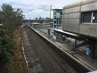
Glenfield railway station is a junction station serving the Sydney suburb of Glenfield in Australia. It is served by Sydney Trains T8 Airport & South, T2 Inner West & Leppington and T5 Cumberland line services, and by limited NSW TrainLink Southern Highlands Line services.

<span class="mw-page-title-main">East Hills railway line</span> Railway line in Sydney, New South Wales, Australia

The East Hills railway line serves the southern and south-western suburbs of Sydney, Australia. The line opened to East Hills in 1931 and was extended to connect to the Main South Line in 1987. Most services along the line form part of the Airport & South Line operated by Sydney Trains.

<span class="mw-page-title-main">Leumeah railway station</span> Railway station in Sydney, New South Wales, Australia

Leumeah station is located on the Main Southern line, serving the Sydney suburb of Leumeah. It is served by Sydney Trains T8 Airport & South line services.

<span class="mw-page-title-main">City of Campbelltown (New South Wales)</span> Local government area in New South Wales, Australia

The City of Campbelltown is a local government area in the Macarthur region of south-western Sydney, in New South Wales, Australia. The area is located about 55 kilometres (34 mi) south west of the Sydney central business district and comprises 312 square kilometres (120 sq mi).

<span class="mw-page-title-main">East Hills, New South Wales</span> Suburb of Sydney, New South Wales, Australia

East Hills, a suburb of local government area City of Canterbury-Bankstown, is located 26 kilometres south-west of the Sydney central business district, in the state of New South Wales, Australia, and is a part of the South-western Sydney region, near larger areas like Revesby and Bankstown.

<span class="mw-page-title-main">Holsworthy railway station, Sydney</span> Railway station in Sydney, New South Wales, Australia

Holsworthy railway station is located on the East Hills line, serving the Sydney suburb of Holsworthy. It is served by Sydney Trains T8 Airport & South line services.

<span class="mw-page-title-main">Woronora River</span> River in New South Wales

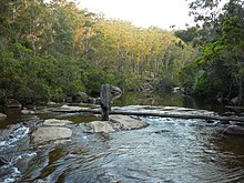
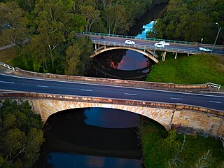
The Woronora River is a perennial river of the Sydney Basin, located in the Sutherland Shire local government area of Greater Metropolitan Sydney, approximately 22 kilometres (14 mi) south of the Sydney central business district, in New South Wales, Australia.

<span class="mw-page-title-main">Cumberland Plain</span> Plain in Australia

The Cumberland Plain, also known as Cumberland Basin, is a relatively flat region lying to the west of Sydney CBD in New South Wales, Australia. An IBRA biogeographic region, Cumberland Basin is the preferred physiographic and geological term for the low-lying plain of the Permian-Triassic Sydney Basin found between Sydney and the Blue Mountains, and it is a structural sub-basin of the Sydney Basin.

<span class="mw-page-title-main">Bike paths in Sydney</span> Bike paths

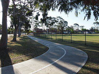
Bike paths in Sydney, New South Wales, Australia, vary widely, with the majority either shared cycle and pedestrian paths or on road paths, and a small number of separated cycleways. In 2009 the Sydney Morning Herald reported that "Sydney's cycleways are not so much an organised network as a fragmented collection of winding paths and half-finished ideas. Most were built or designed when cycling was viewed as a pleasant pastime rather than a practical form of travel and are now poorly suited to commuting."

<span class="mw-page-title-main">Lugarno, New South Wales</span> Suburb of Sydney, New South Wales, Australia

Lugarno is a suburb situated in the St George area of southern Sydney, in the state of New South Wales, Australia. It is located in the local government area of the Georges River Council, 23 kilometres south of the Sydney central business district.

<span class="mw-page-title-main">Chipping Norton Lake</span> Lake in New South Wales, Australia

Chipping Norton Lake is a 49-hectare (120-acre) artificial lake and regional park located in the Sydney suburb of Chipping Norton, New South Wales, Australia. It is a part of the Georges River system. Chipping Norton Lake is managed by Liverpool City Council. The lake is an important recreational area for Liverpool, City of Canterbury-Bankstown and Fairfield City Council.

The Cooks River cycleway, also called the Bay to Bay Shared Pathway, is a 30-kilometre-long (19 mi) shared use path for cyclists and pedestrians in the Inner West of Sydney, New South Wales, Australia. The north-western terminus of the cycleway is in Settlers' Park, Ryde, from where it proceeds south, crossing the Parramatta River and skirting Homebush Bay to the Cooks River, from where it generally follows the course of the river south and east to the south-eastern terminus on Botany Bay at Kyeemagh. The alternative name "Bay to Bay" or "B2B" path refers to Homebush Bay and Botany Bay. The path connects a series of parklands in the City of Ryde and the Municipality of Strathfield, as well as the riverside green spaces along the course of the Cooks River.

The Holsworthy railway line was located in South-western Sydney. It was constructed during World War I, mainly using labour from the Holsworthy Internment Camp. Its purpose was to service the Holsworthy army facilities opening on 21 January 1918.

<span class="mw-page-title-main">St Helen's Park</span> Historic site in New South Wales, Australia

St Helen's Park is a heritage-listed former school, experimental farm, private residence and guesthouse and now homestead located at St Helens Park Drive, St Helens Park, City of Campbelltown, New South Wales, Australia. It was designed by George Allen Mansfield and built in 1887 by George Lusted. It is also known as St. Helen's Park and Egypt Farm. The property is privately owned. It was added to the New South Wales State Heritage Register on 2 April 1999.

<span class="mw-page-title-main">Lennox River</span> River in New South Wales, Australia

The Lennox River is the proposed name for a waterway located in Sydney's South-Western Suburbs. The existing waterway is the tidal reach of Prospect Creek, a tributary of the Georges River. A proposal has been made to upgrade and reclassify the waterway as a 'river'. The proposed river would be 6.5 kilometres (4 mi) long, starting at the confluence of Orphan School Creek and Prospect Creek at Fairfield and flowing to the Georges River emptying into Dhurawal Bay at Garrison Point.

References

  1. 1 2 "Georges River". Geographical Names Register (GNR) of NSW. Geographical Names Board of New South Wales . Retrieved 4 January 2013. OOjs UI icon edit-ltr-progressive.svg
  2. 1 2 Pollon, Frances, ed. (1990). The Book of Sydney Suburbs. Australia: Angus & Robertson. p. 107. ISBN   0-207-14495-8.
  3. "Georges River". Estuaries of NSW. Office of Environment and Heritage. 26 April 2012. Retrieved 4 January 2013.
  4. "Georges River information page". Campbelltown City Council. Archived from the original on 2008-07-30.
  5. Roy, P. S.; Williams, R. J.; Jones, A. R.; Yassini, I.; et al. (2001). "Structure and Function of South-east Australian Estuaries". Estuarine, Coastal and Shelf Science . 53 (3): 351–384. Bibcode:2001ECSS...53..351R. doi:10.1006/ecss.2001.0796.
  6. "Simmo's Beach Reserve". Macarthur Branch: Activities. National Parks Association of NSW. 2011. Archived from the original on 25 February 2011. Retrieved 4 January 2013.
  7. "Bushwalkers Basin". Macarthur Branch: Activities. National Parks Association of NSW. 2011. Archived from the original on 26 April 2013. Retrieved 4 January 2013.
  8. "Freres Crossing". Macarthur Branch: Activities. National Parks Association of NSW. 2011. Archived from the original on 25 February 2011. Retrieved 4 January 2013.
  9. River Health Monitoring Program Archived 2021-01-27 at the Wayback Machine Georges Riverkeeper
  10. Connor, John (2002). The Australian frontier wars, 1788–1838. Sydney: UNSW Press. ISBN   0-86840-756-9.
  11. Hayworth, Robert (2012). "The several 'discoveries' of Sydney's Georges River: precursors to the Tom Thumb expedition". ResearchGate. University of New England / Journal of Colonial History. Retrieved 19 Dec 2023.
  12. "Gertrude Point · Lugarno NSW 2210, Australia". Google Maps. Retrieved 2021-08-18.
  13. "Liverpool Weir". Heritage Branch, New South Wales waling Department of Planning. Retrieved 24 September 2010.
  14. Project Summaries - 2006 Urban Sustainability Major Program Grants NSW Department of Environment and Climate Change
  15. "Downloading [PEPart1070403.PDF]". Archived from the original on 2011-06-17. Retrieved 2010-07-20.
  16. "23rd Biennale of Sydney, River Project". Georges Riverkeeper. Retrieved 2023-12-14.
  17. Ly, Philip (2015-11-04). "Mandaeans to baptise in Georges River". dailytelegraph. Retrieved 2023-12-14.
  18. Hromas, Jessica (2020-03-27). "Keeping the faith: Sydney's Mandaeans perform baptism rituals – in pictures". the Guardian. Retrieved 2023-12-14.
  19. "Georges River Bridge". Roads and Traffic Authority, New South Wales. Retrieved 20 September 2010.
  20. "Kings Falls Bridge over Georges River". Roads and Traffic Authority, New South Wales.