
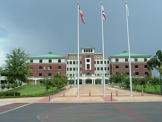
Tallahassee is the capital city of the U.S. state of Florida. It is the county seat and only incorporated municipality in Leon County. Tallahassee became the capital of Florida, then the Florida Territory, in 1824. In 2022, the estimated population was 201,731, making it the eighth-most populous city in the state of Florida. It is the principal city of the Tallahassee, Florida Metropolitan Statistical Area, which itself had an estimated population of 390,992 as of 2022. Tallahassee is the largest city in the Florida Big Bend and Florida Panhandle region, and the main center for trade and agriculture in the Florida Big Bend and Southwest Georgia regions.

Hernando County is a county located on the west central coast of the U.S. state of Florida. As of the 2020 census, the population was 194,515. Its county seat is Brooksville, and its largest community is Spring Hill.

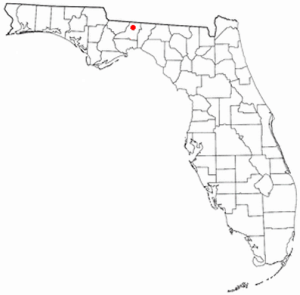
Leon County is a county in the Panhandle of the U.S. state of Florida. It was named after the Spanish explorer Juan Ponce de León. As of the 2020 census, the population was 292,198.
Volusia County is located in the east-central part of the U.S. state of Florida between the St. Johns River and the Atlantic Ocean. As of the 2020 census, the county was home to 553,543 people, an increase of 11.9% from the 2010 census. It was founded on December 29, 1854, from part of Orange County, and was named for the community of Volusia, located in northwestern Volusia County. Its first county seat was Enterprise. Since 1887, its county seat has been DeLand.

Pinellas Park is a city located in central Pinellas County, United States. The population was 53,093 at the 2020 census. The city is the fourth largest city in Pinellas County. The City of Pinellas Park was incorporated in 1914. It is part of the Tampa–St. Petersburg–Clearwater Metropolitan Statistical Area, most commonly referred to as the Tampa Bay Area.

Columbia is a town in, and the parish seat of, Caldwell Parish, Louisiana, United States. The population was 277 in 2020.

Chillum is an unincorporated area and census-designated place in Prince George's County, Maryland, United States, bordering Washington, D.C., and Montgomery County.

Ashby is a town in Middlesex County, Massachusetts, United States. The population was 3,193 at the 2020 census, which makes it the least populous municipality in Middlesex County. Ashby is primarily a bedroom community, consisting almost entirely of single family homes and a limited number of businesses.

Carmel is a town in Putnam County, New York, United States. As of the 2020 United States census, the town had a population of 33,576.

Mount Pleasant is a large suburban town in Charleston County, South Carolina, United States. In the Lowcountry, it is the fourth-most populous municipality in South Carolina, and for several years was one of the state's fastest-growing areas, doubling in population between 1990 and 2000. The population was 90,801 at the 2020 census. It is part of the Charleston metropolitan area.

Crosby is a census-designated place in Harris County, Texas, United States. The population was 3,417 at the 2020 census.

Hempstead is a city in and the county seat of Waller County, Texas, United States, part of the Houston–The Woodlands–Sugar Land metropolitan area.
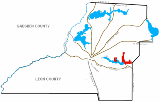
Bradfordville is an unincorporated community and census-designated place (CDP) in northern Leon County, Florida, United States. The population was 19,183 at the 2020 census. It is part of the Tallahassee, Florida Metropolitan Statistical Area. It is both 8 miles (13 km) north of Tallahassee and south of the Florida/Georgia state line at the intersection of US 319 and County Road 0342. Its elevation is 223 feet.

Miccosukee is a small unincorporated community and census-designated place (CDP) in northeastern Leon County, Florida, United States. The population was 383 at the 2020 census. It is part of the Tallahassee, Florida Metropolitan Statistical Area. It is located at the junction of County Road 59 and County Road 151. Miccosukee was a major center of the Miccosukee tribe, one of the tribes of the developing Seminole nation, during the 18th century.
Evergreen Hills Plantation was a large cotton plantation of 6700 acres (27 km2) located in eastern Leon County, Florida, United States established by Green H. Chaires.

Chaires is an unincorporated community and census-designated place (CDP) located just east of Tallahassee in Leon County, Florida, United States. The population was 308 at the 2020 census. It is part of the Tallahassee, Florida Metropolitan Statistical Area. It is located near the intersection of Chaires Cross Road and Capitola Road, northeast of Lake Lafayette and the Edwards Wildlife Area. The ZIP Code for Chaires is 32317.

Grahamsville is a hamlet at the junction of NY 42 and 55 in the Town of Neversink, in Sullivan County, New York, United States. It is near the western end of Rondout Reservoir, and is the southernmost community in the Catskill Park. It has the ZIP Code 12740 and the 985 telephone exchange in the 845 area code.
The history of Tallahassee, Florida, much like the history of Leon County, dates back to the settlement of the Americas. Beginning in the 16th century, the region was colonized by Europeans, becoming part of Spanish Florida. In 1819, the Adams–Onís Treaty ceded Spanish Florida, including modern-day Tallahassee, to the United States. Tallahassee became a city and the state capital of Florida in 1821; the American takeover led to the settlements' rapid expansion as growing numbers of cotton plantations began to spring up nearby, increasing Tallahassees' population significantly.

Vernon Township is one of nine townships in Hancock County, Indiana, United States. As of the 2020 census, its population was 15,615 and it contained 4,322 housing units.
Rosharon, is an unincorporated community and census-designated place (CDP) located entirely in Brazoria County, Texas, United States, at the intersection of Farm to Market Road 521 and Farm to Market Road 1462. As of the 2010 census, it had a population of 1,152. There are areas outside of the CDP, with Rosharon postal addresses, in Fort Bend County.


