
Carson City is an independent city and the capital of the U.S. state of Nevada. As of the 2020 census, the population was 58,639, making it the sixth largest city in Nevada. The majority of the city's population lives in Eagle Valley, on the eastern edge of the Carson Range, a branch of the Sierra Nevada, about 30 miles (50 km) south of Reno. The city is named after the mountain man Kit Carson. The town began as a stopover for California-bound immigrants, but developed into a city with the Comstock Lode, a silver strike in the mountains to the northeast. The city has served as Nevada's capital since statehood in 1864; for much of its history it was a hub for the Virginia and Truckee Railroad, although the tracks were removed in 1950.

Shelby County is a county located in the U.S. state of Kentucky. As of the 2020 census, the population was 48,065. Its county seat is Shelbyville. The county was founded in 1792 and named for Isaac Shelby, the first Governor of Kentucky. Shelby County is part of the Louisville/Jefferson County, KY–IN Metropolitan Statistical Area. Shelby County's motto is "Good Land, Good Living, Good People".

Douglas County is a county in the northwestern part of the U.S. state of Nevada. As of the 2020 Census, the population was 49,488. Its county seat is Minden. Douglas County comprises the Gardnerville Ranchos, NV Micropolitan Statistical Area, which is also included in the Reno–Carson City–Fernley, NV Combined Statistical Area.
Platte County is a county located in the northwestern portion of the U.S. state of Missouri and is part of the Kansas City metropolitan area. As of the 2020 census, the population was 106,718. Its county seat is Platte City. The county was organized December 31, 1838, from the Platte Purchase, named for the Platte River. The Kansas City International Airport is located in the county, approximately one mile west of Interstate 29 between mile markers 12 and 15. The land for the airport was originally in an unincorporated portion of Platte County before being annexed by Platte City, and eventually Kansas City.

Rancho Santa Margarita is a city in Orange County, California, United States. One of Orange County's youngest cities, Rancho Santa Margarita is a master-planned community. The population was 47,853 at the 2010 census, up from 47,214 at the 2000 census. Although it is named for Rancho Santa Margarita y Las Flores, which was in San Diego County, the city limits fall within the borders of Rancho Mission Viejo. At 20 characters long, it is the longest city name in California.

Burlington is a home rule municipality and the county seat and most populous community of Kit Carson County, Colorado, United States. The city population was 3,172 at the 2020 United States Census.

Plant City is an incorporated city in Hillsborough County, Florida, United States, approximately midway between Brandon and Lakeland along Interstate 4. The population was 39,764 at the 2020 census.

Springfield is a city in Effingham County, Georgia, United States. The population was 2,852 at the 2010 census, up from 1,821 in 2000. The city is the county seat of Effingham County. Springfield is part of the Savannah Metropolitan Statistical Area.
Renwick is a city in Humboldt County, Iowa, United States. The population was 234 at the time of the 2020 census.

Pikesville is a census-designated place (CDP) in Baltimore County, Maryland, United States. Pikesville is just northwest of the Baltimore city limits. It is the northwestern suburb closest to Baltimore.

Surfside Beach, also known locally as Surfside, is a city in Brazoria County, Texas, United States, that is situated on Follet's Island by the Gulf of Mexico near the city of Freeport. The population was 482 at the 2010 census. The city has claimed the "Cradle of Texas Liberty" title due to the fact that the Treaty of Velasco which ended hostilities between Texas and Mexico was signed at Fort Velasco, which was located near the city's current City Hall.
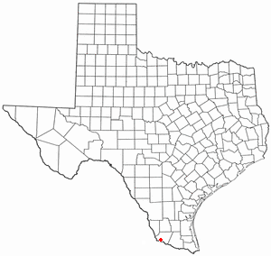
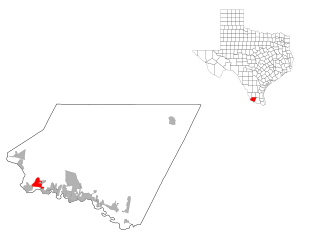
Garceno is a census-designated place (CDP) in Starr County, Texas, United States. The population was 420 at the 2010 census down from 1,438 at the 2000 census.
Roma Creek is a former census-designated place (CDP) in Starr County, Texas, United States. The population was 350 at the 2010 census down from 610 at the 2000 census.

Benbrook is a town located in the southwestern corner of Tarrant County, Texas, and a suburb of Fort Worth. As of the 2010 United States Census, the population was 21,234, reflecting an increase of 1,026 from the 20,208 counted in the 2000 Census, which had in turn increased by 644 from the 19,564 counted in the 1990 Census.

Rio Bravo is a city in Webb County, in the American state of Texas. It lies sixteen miles south of Laredo on Highway 83, and sits on the left bank of the Rio Grande. Founded in 1982 by the property developer Cecil McDonald, Rio Bravo was incorporated as a city in 1989. It had a population of 4,794 at the 2010 census.

Zephyr Cove is a community and census-designated place (CDP) in Douglas County, Nevada, United States. The population was 565 at the 2010 census. Prior to 2010 it was part of the Zephyr Cove–Round Hill Village CDP.
Blue Summit is an unincorporated community and census-designated place (CDP) lodged between Kansas City and Independence in Jackson County, Missouri, United States. It is part of the Kansas City metropolitan area.
Sunset Acres is a census-designated place (CDP) in Webb County, Texas, United States. This was a new CDP formed from parts of the Botines CDP prior to the 2010 census with a population of 23.
Los Minerales is a census-designated place (CDP) in Webb County, Texas, United States. This was a new CDP formed from parts of the Ranchos Penitas West CDP and additional area prior to the 2010 census with a population of 20.