Cartosat-3

Last updated

Cartosat-3
Render of Cartosat-3 satellite in deployed configuration.png
Render of Cartosat-3 satellite in deployed configuration
NamesCartoSat-3
Mission type Earth Observation
Operator ISRO
COSPAR ID 2019-081A OOjs UI icon edit-ltr-progressive.svg
SATCAT no. 44804
Website https://www.isro.gov.in/
Mission duration5 years (planned)
4 years, 4 months and 30 days (in progress)
Spacecraft properties
SpacecraftCartoSat-3
Bus IRS-2
Manufacturer Indian Space Research Organisation
Launch mass1,625 kg (3,583 lb) [1]
Power2000 watts
Start of mission
Launch date27 November 2019, 03:58 UTC [2]
Rocket Polar Satellite Launch Vehicle-XL, PSLV-C47
Launch site Satish Dhawan Space Centre, Second Launch Pad (SLP)
Contractor Indian Space Research Organisation
Entered service24 February 2020
Orbital parameters
Reference system Geocentric orbit
Regime Sun-synchronous orbit
Periapsis altitude 450 km (280 mi)
Apoapsis altitude 450 km (280 mi)
Inclination 97.5°
Period 100.0 minutes
Instruments
Panchromatic Camera (PAN)
Multispectral VNIR (MX)
 

Cartosat-3 is an advanced Indian Earth observation satellite built and developed by Indian Space Research Organisation (ISRO), which replaces the Indian Remote Sensing Satellite (IRS) series. It has a panchromatic resolution of 0.25 metres making it one of the imaging satellite with highest resolution in the world at the time of launch and MX of 1 metre with a high quality resolution which is a major improvement from the previous payloads in the Cartosat series. [3] [4] [5]

Contents

Potential uses include weather mapping, cartography or defence, and strategic applications. [3]

Overview

Cartosat-3 has a resolution of 25 cm (10"). [6] It uses 1.2 m optics with 60% of weight removal compared to Cartosat-2. Other features include the use of adaptive optics, acousto optical devices, in-orbit focusing using MEMs and large area-light weight mirrors and advanced sense with a high quality resolution. It has a planned mission life of 5 years. [7] Approved cost of Cartosat-3 is 351.16 crore (US$44 million). [8] It captures Panchromatic and Multispectral images with spectral bandwidth from 0.45 - 0.9 μm which includes visible blue (0.45 - 0.52 μm), visible green (0.52 - 0.59 μm), visible red (0.62 - 0.68 μm) and near IR (0.77 - 0.86 μm). [9]

History

Cartosat-3 is the 3rd generation of high-resolution imaging satellites developed by ISRO. [10] It was developed in response to increased demand for imaging services to address urban planning, rural resource and infrastructure development needs. [11]

Launch

PSLV-C47 lifting off from Second Launch Pad (SLP) with Cartosat-3. PSLV C47 Cartosat-3 lifting off from Second Launch Pad 002.jpg
PSLV-C47 lifting off from Second Launch Pad (SLP) with Cartosat-3.

PSLV-C47 carrying Cartosat-3 was launched on 27 November 2019 at 03:58 UTC using XL variant of Polar Satellite Launch Vehicle from the Second Launch Pad (SLP) of Satish Dhawan Space Centre into a Sun-synchronous orbit of 450 kilometers. Thirteen commercial ride-sharing 3U cubesats including twelve SuperDoves (Flock-4p) [12] by Planet Labs and one Meshbed by Analytical Space of United States were also put in orbit using the same launch vehicle. [7] [13] Commercial ride-share was arranged by NewSpace India Limited, Spaceflight Industries and ISILaunch. [14] [15]

See also

Related Research Articles

<span class="mw-page-title-main">Cartosat-1</span>

Cartosat-1 is a stereoscopic Earth observation satellite in a Sun-synchronous orbit, and the first one of the Cartosat series of satellites. The eleventh satellite of ISRO in Indian Remote Sensing Satellite (IRS) series. The satellite was launched by Indian Space Research Organisation and is operated by NTRO. Weighing around 1560 kg at launch, its applications will mainly be towards cartography in India.

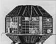
Technology Experiment Satellite (TES) is an Indian remote sensing and photo-reconnaissance satellite.

Cartosat-2 was an Earth observation satellite in a Sun-synchronous orbit and the second of the Cartosat series of satellites. The satellite was built, launched and maintained by the Indian Space Research Organisation (ISRO). Weighing around 680 kg at launch, its applications were mainly be towards cartography. It was launched by the Polar Satellite Launch Vehicle PSLV C7 launch vehicle on 10 January 2007.

Cartosat-2A is an Earth observation satellite in a Sun-synchronous orbit and the third of the Cartosat series of satellites. The satellite is the thirteenth satellite in the Indian Remote Sensing (IRS) satellite series to be built, launched by the Indian Space Research Organisation.

The Integrated Space Cell was the nodal agency within the Government of India with oversight of the security of its space based military and civilian hardware systems. It was to be jointly operated by all the three services of the Indian Armed Forces, the civilian Defence Research and Development Organisation and the Indian Space Research Organisation (ISRO). This agency was superseded by Defence Space Agency in 2019.[better source needed]

Cartosat-2B is an Earth observation satellite in a Sun-synchronous orbit and the fourth of the Cartosat series of satellites. The satellite is the seventeenth satellite in the Indian Remote Sensing (IRS) satellite series to be built by the Indian Space Research Organisation (ISRO).

IRS-1D is the seventh satellite in Indian Remote Sensing satellite series of Earth Observation satellites, built, launched and maintained by Indian Space Research Organisation (ISRO). The satellite has similar capabilities as that of ISRO's IRS-1C satellite with some improvements added for better imagery particularly in thematic mapping.

The Cartosat is a series of Indian optical Earth observation satellites built and operated by the Indian Space Research Organisation (ISRO). The Cartosat series is a part of the Indian Remote Sensing Program. They are used for Earth's resource management, defence services and monitoring.

Cartosat-2C is an Earth observation satellite in a Sun-synchronous orbit (SSO) and is a fifth flight unit of Cartosat series of satellites. It is a geostationary satellite and appears stationary over a place on the earth. The satellite is built at space application centre Ahmedabad, launched and maintained by the Indian Space Research Organisation (ISRO). It was launched on 22 June 2016.

<span class="mw-page-title-main">EOS-04</span> Indian radar imaging satellite

EOS-04 or Earth Observation Satellite - 04 is an Indian Space Research Organisation Radar Imaging Satellite designed to provide high-quality images under all weather conditions for applications such as Agriculture, Forestry & Plantations, Soil Moisture & Hydrology and Flood mapping. It is a follow on to RISAT-1 satellite with similar configuration. The satellite is developed by the ISRO and it is the sixth in a series of RISAT satellites.

Cartosat-2E is an Earth observation satellite developed by the Indian Space Research Organisation (ISRO), and is the seventh in the Cartosat series. It is designed to collect high-resolution, large-scale imagery for use in urban planning, infrastructure development, utilities planning, and traffic management.

Alsat-1B is an Algerian satellite operated by the Agence Spatiale Algerienne for agricultural and disaster monitoring. The contract for the mission was signed in July 2014. The satellite is based on the SSTL-100 bus. The satellite weighs 103 kilograms (227 lb) and carries an Earth imaging payload with 12-metre (39 ft) panchromatic imager and 24-metre (79 ft) multispectral cameras.

Alsat-2A is an Algerian satellite operated by the Algerian Space Agency for cartography, management of agriculture, forestry, water, mineral and oil resources. The satellite weighs 117 kilograms (258 lb) and carries an Earth optical payload.

<span class="mw-page-title-main">Cartosat-2D</span> Indian Earth observation satellite

Cartosat-2D is an Earth observation satellite in a Sun-synchronous orbit (SSO) and the fifth of the Cartosat series of satellites. The satellite is built, launched and maintained by the Indian Space Research Organisation (ISRO). Cartosat-2D has a mass of 714 kg.

<span class="mw-page-title-main">Cartosat-2F</span> Indian Earth observation satellite

Cartosat-2F is the eighth satellite in the Cartosat-2 Series. It is an Earth observation satellite launched on the PSLV-C40 mission by the Indian Space Research Organisation (ISRO).

<span class="mw-page-title-main">Microsat (ISRO)</span> Indian Earth observation satellite

Microsat-TD was an Earth observing satellite developed by ISRO. Its launch marked India's 100 satellites in space. This satellite could capture images at night by imaging in infrared spectrum.

<span class="mw-page-title-main">PSLV-C46</span> Polar satellite launch vehicle mission by ISRO

PSLV-C46 was a mission of the Indian Polar Satellite Launch Vehicle (PSLV) rocket, launched on Thursday, May 22, 2019, at 05:30 Hrs (IST) by the Indian Space Research Organisation (ISRO) from the first launch pad of the Satish Dhawan Space Centre at Sriharikota, Andhra Pradesh. In this mission, the 'Core-Alone' configuration of PSLV was flown.

<span class="mw-page-title-main">PSLV-C47</span> Polar satellite launch vehicle mission by ISRO

PSLV-C47 was a mission of the Indian Polar Satellite Launch Vehicle (PSLV) rocket, launched on Thursday, November 27, 2019, at 09:27 Hrs (IST) by the Indian Space Research Organisation (ISRO) from the second launch pad of the Satish Dhawan Space Centre at Sriharikota, Andhra Pradesh.

<span class="mw-page-title-main">PSLV C7</span> Polar Satelite Launch Vehicle mission by ISRO

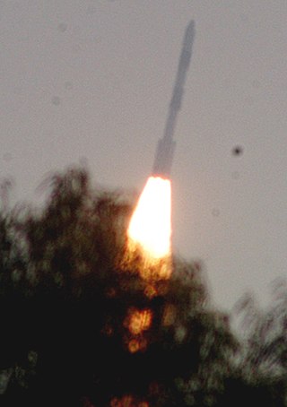
PSLV-C7 was a mission of the Indian Polar Satellite Launch Vehicle (PSLV) rocket, launched on January 10, 2007, by the Indian Space Research Organisation (ISRO) from the Satish Dhawan Space Centre at Sriharikota, Andhra Pradesh.

References

  1. "PSLV C47/Cartosat-3 Mission Launch Kit" (PDF). Archived from the original (PDF) on 19 November 2019. Retrieved 27 November 2019.
  2. "PSLV-C47 successfully launches Cartosat-3 and 13 Commercial nanosatellites into Sun-Synchronous Polar Orbit". Archived from the original on 27 November 2019. Retrieved 27 November 2019.
  3. 1 2 Prasad, Narayan (28 November 2019). "Cartosat-3 in space — here is how ISRO can now exploit its full potential". The Print. Retrieved 2 December 2019.
  4. "ISRO reschedules CARTOSAT 3 launch to November 27". Economic Times. Retrieved 23 November 2019.
  5. Vaitheesvaran, Bharani (22 November 2019). "ISRO's Cartosat-3 launch next week". Economic Times. Retrieved 23 November 2019.
  6. N. Gopal Raj. "ISRO plans a new high-resolution earth satellite". The Hindu. Archived from the original on 19 January 2018. Retrieved 19 January 2018.
  7. 1 2 "ISRO's tracking centre assumes control of CARTOSAT-3". The Hindu. 27 November 2019. Retrieved 27 November 2019.
  8. "Government of India, Department of Space, Lok Sabha: Starred Question No. 232 to be answered on Wednesday, August 04, 2021" (PDF). 4 August 2021. Archived (PDF) from the original on 4 August 2021. Retrieved 4 August 2021.
  9. "Cartosat 3 nrsc" (PDF). www.nrsc.gov.in.
  10. "PSLV-C47 / Cartosat-3 Mission". Archived from the original on 28 November 2019. Retrieved 23 November 2019.
  11. "Cartosat-3". Archived from the original on 3 December 2019. Retrieved 5 March 2020.
  12. "12 SuperDove Satellites Hitching a Ride to Orbit on the PSLV" . Retrieved 27 November 2019.
  13. Clark, Stephen. "PSLV delivers India's highest-resolution Earth observation satellite to orbit". Spaceflight Now. Retrieved 27 November 2019.
  14. "Successful ISILAUNCH29 campaign". ISILaunch. 27 November 2019. Retrieved 27 November 2019.
  15. "Getting Meshbed to Space!". Spaceflight. 14 October 2019. Retrieved 27 November 2019.