Ionospheric Connection Explorer

Last updated

Ionospheric Connection Explorer
ICON and Airglow - Daytime View.jpg
ICON (Explorer 96) satellite
NamesExplorer 96
ICON
Mission type Ionospheric research
Operator UC Berkeley SSL  / NASA
COSPAR ID 2019-068A OOjs UI icon edit-ltr-progressive.svg
SATCAT no. 44628
Website icon.ssl.berkeley.edu
Mission duration2 years (planned)
3 years, 8 months, 20 days (in progress)
Spacecraft properties
SpacecraftExplorer XCVI
Spacecraft typeIonospheric Connection Explorer
Bus LEOStar-2 [1]
Manufacturer University of California, Berkeley  / Northrop Grumman
Launch mass288 kg (635 lb) [2]
DimensionsHeight: 193 cm (76 in) and 106 cm (42 in) of diameter [3]
Solar panel: 254 × 84 cm (100 × 33 in)
Power780 watts
Start of mission
Launch date11 October 2019, 02:00 UTC [4]
Rocket Pegasus XL (F44)
Launch site Cape Canaveral Skid Strip, Stargazer [5]
Contractor Northrop Grumman
Entered serviceNovember 2019
Orbital parameters
Reference system Geocentric orbit
Regime Low Earth orbit
Perigee altitude 575 km (357 mi)
Apogee altitude 603 km (375 mi)
Inclination 27.00°
Period 97.00 minutes
Explorer program
  TESS (Explorer 95)
IXPE (Explorer 97) 
 

Ionospheric Connection Explorer (ICON) [6] is a satellite designed to investigate changes in the ionosphere of Earth, the dynamic region high in our atmosphere where terrestrial weather from below meets space weather from above. ICON studies the interaction between Earth's weather systems and space weather driven by the Sun, and how this interaction drives turbulence in the upper atmosphere. It is hoped that a better understanding of this dynamic will mitigate its effects on communications, GPS signals, and technology in general. [6] [7] It is part of NASA's Explorer program and is operated by University of California, Berkeley's Space Sciences Laboratory. [8]

Contents

On 12 April 2013, NASA announced that ICON, along with Global-scale Observations of the Limb and Disk (GOLD), had been selected for development with the cost capped at US$200 million, [9] excluding launch costs. [10] The principal investigator of ICON is Thomas Immel at the University of California, Berkeley. [9] [11]

ICON was originally scheduled to launch in June 2017 and was repeatedly delayed because of problems with its Pegasus XL launch vehicle. It was next due to launch on 26 October 2018 but the launch was rescheduled to 7 November 2018, and postponed again just 28 minutes before launch. [12] ICON was successfully launched on 11 October 2019, at 02:00 UTC. [4]

Overview

ICON's observational geometry, showing both in-situ and remote sensing of the ionosphere-thermosphere system. The ICON observational geometry, showing both in situ and remote sensing of the ionosphere-thermosphere system.jpg
ICON's observational geometry, showing both in-situ and remote sensing of the ionosphere-thermosphere system.

ICON will perform a two-year mission to observe conditions in both the thermosphere and ionosphere. [9] ICON is equipped with four instruments: a Michelson interferometer, built by the United States Naval Research Laboratory (NRL), measures the winds and temperatures in the thermosphere; an ion drift meter, built by University of Texas at Dallas, measures the motion of charged particles in the ionosphere; and two ultraviolet imagers built at University of California, Berkeley, observe the airglow layers in the upper atmosphere in order to determine both ionospheric and thermospheric density and composition.

Many low-Earth orbiting satellites, including the International Space Station (ISS), fly through the ionosphere and can be affected by its changing electric and magnetic fields. The ionosphere also acts as a conduit for many communications signals, such as radio waves and the signals that make GPS systems work. The ionosphere is where space weather manifests, creating unexpected conditions; electric currents can cause electrical charging of satellites, changing density can affect satellite orbits, and shifting magnetic fields can induce current in power systems, causing strain, disrupting communications and navigation or even triggering blackouts. [3] Improved understanding of this environment can help predict such events and improve satellite safety and design. [3]

Launch planning

Upon initial completion and delivery of the ICON observatory in 2016, launch plans centered around the launch range at Kwajalein Atoll in the Pacific Ocean. [13] [14] ICON was originally scheduled to launch in June 2017, but was repeatedly delayed because of problems with its Pegasus XL launch vehicle. The launch vehicle was mated to its air-launch aircraft Stargazer for a launch attempt in June 2018. [5] This launch was cancelled days before because the rocket showed issues on the first leg of the ferry flight to Kwajalein. Given the availability of the launch range in Cape Canaveral, and a review of the suitability of this site, it was adopted as the ICON launch site. [13] The October 2018 launch from Florida was scheduled after an initial review of the avionics issues. [13] Whereas the delays in 2017 were due to concerns with rocket-payload and fairing separation systems, the 2018 delays were due to noise in the rocket avionics systems. The issues resulted finally in the 2018 Cape Canaveral launch being scrubbed minutes before the scheduled launch. These issues were ultimately resolved and ICON launched from Cape Canaveral on 11 October 2019 at 02:00 UTC. After an approximately month-long commissioning period, ICON began sending back its first science data in November 2019.

Science payload

ICON carries four scientific instruments designed to image even the faintest plasma or airglow to build up a picture of the ionosphere's density, composition and structure. The complete instrument payload has a mass of 130 kg (290 lb) and are listed below: [15] [16]

MIGHTI was developed at the United States Naval Research Laboratory (NRL), IVM at the University of Texas, and EUV and FUV were developed at the University of California, Berkeley. [15] MIGHTI measures wind speed and temperature between 90 km (56 mi) and 300 km (190 mi) in altitude. [17] The velocity measurements are gathered by observing the Doppler shift in the red and green lines of atomic oxygen. This is done with the Doppler Asymmetric Spatial Heterodyne (DASH) which uses échelle gratings. [17] The temperature measurements are done by photometeric observations with a CCD. [17] MIGHTI is designed to detect wind speeds as low as 16 km/h (9.9 mph), even though the spacecraft is traveling at over 23,000 km/h (14,000 mph) (to stay in orbit). [18]

IVM collects in situ data about ions in the local environment around the spacecraft, whereas EUV and FUV are spectrographic imagers. EUV is a 1-dimension limb imager designed to observe height and density of the daytime ionosphere by detecting the glow of oxygen ions and other species at wavelengths between 55 and 85 nm. FUV is a 2-dimension imager that observes the limb and below at 135 and 155 nm, where bright emissions of atomic oxygen and molecular nitrogen are found [18]

The solar panel produces 780 watts, [2] but the observatory's power consumption ranges between 209 and 265 watts when in science mode. [3]

Mission Operations

Once launched, and for the duration of its two-year science mission, the ICON observatory is controlled and operated by the Mission Operations Center (MOC) at the Space Sciences Laboratory at University of California, Berkeley. [19] The UCB MOC currently operates seven NASA satellites. ICON was placed into a 27.00° inclination orbit, and communications are through Tracking and Data Relay Satellite System (TDRSS), the orbiting NASA communications network. Ground contacts with ICON are performed mainly from the Berkeley Ground Station, an 11 m (36 ft) dish, with backup contacts out of Wallops Flight Facility (WFF), Virginia and Santiago, Chile.

Loss of Contact

The NASA ICON team lost contact with the ICON spacecraft on 25 November 2022. A fail-safe system designed to reset the spacecraft computer after 8 days with no receipt of commands from the ground failed to restore communications after it elapsed on 5 December 2022. [20]

See also

Related Research Articles

<span class="mw-page-title-main">Geostationary Operational Environmental Satellite</span> United States weather forecasting satellite

The Geostationary Operational Environmental Satellite (GOES), operated by the United States' National Oceanic and Atmospheric Administration (NOAA)'s National Environmental Satellite, Data, and Information Service division, supports weather forecasting, severe storm tracking, and meteorology research. Spacecraft and ground-based elements of the system work together to provide a continuous stream of environmental data. The National Weather Service (NWS) and the Meteorological Service of Canada use the GOES system for their North American weather monitoring and forecasting operations, and scientific researchers use the data to better understand land, atmosphere, ocean, and climate dynamics.

<span class="mw-page-title-main">Space weather</span> Branch of space physics and aeronomy

Space weather is a branch of space physics and aeronomy, or heliophysics, concerned with the time varying conditions within the Solar System, including the solar wind, emphasizing the space surrounding the Earth, including conditions in the magnetosphere, ionosphere, thermosphere, and exosphere. Space weather is distinct from, but conceptually related to, the terrestrial weather of the atmosphere of Earth. The term "space weather" was first used in the 1950s and came into common usage in the 1990s. Later, it was generalized to a "space climate" research discipline, which focuses on general behaviors of longer and larger-scale variabilities and effects.

<span class="mw-page-title-main">GALEX</span> NASA satellite of the Explorer program

Galaxy Evolution Explorer was a NASA orbiting space telescope designed to observe the universe in ultraviolet wavelengths to measure the history of star formation in the universe. In addition to paving the way for future ultraviolet missions, the space telescope allowed astronomers to uncover mysteries about the early universe and how it evolved, as well as better characterize phenomena like black holes and dark matter. The mission was extended three times over a period of 10 years before it was decommissioned in June 2013. GALEX was launched on 28 April 2003 and decommissioned in June 2013.

Pegasus is an air-launched launch vehicle developed by Orbital Sciences Corporation (OSC) and now built and launched by Northrop Grumman. Pegasus is the world's first privately developed orbital launch vehicle. Capable of carrying small payloads of up to 443 kg (977 lb) into low Earth orbit, Pegasus first flew in 1990 and remains active as of 2021. The vehicle consists of three solid propellant stages and an optional monopropellant fourth stage. Pegasus is released from its carrier aircraft at approximately 12,000 m (39,000 ft), and its first stage has a wing and a tail to provide lift and attitude control while in the atmosphere. Notably, the first stage does not have a thrust vector control (TVC) system.

Orbital Sciences Corporation was an American company specializing in the design, manufacture, and launch of small- and medium- class space and launch vehicle systems for commercial, military and other government customers. In 2014, Orbital merged with Alliant Techsystems to create a new company called Orbital ATK, Inc., which in turn was purchased by Northrop Grumman in 2018. The remnants of the former Orbital Sciences Corporation today are a subsidiary of Northrop Grumman, known as Northrop Grumman Space Systems.

<span class="mw-page-title-main">IMAGE (spacecraft)</span> NASA satellite of the Explorer program

IMAGE is a NASA Medium Explorer mission that studied the global response of the Earth's magnetosphere to changes in the solar wind. It was believed lost but as of August 2018 might be recoverable. It was launched 25 March 2000, at 20:34:43.929 UTC, by a Delta II launch vehicle from Vandenberg Air Force Base on a two-year mission. Almost six years later, it unexpectedly ceased operations in December 2005 during its extended mission and was declared lost. The spacecraft was part of NASA's Sun-Earth Connections Program, and its data has been used in over 400 research articles published in peer-reviewed journals. It had special cameras that provided various breakthroughs in understanding the dynamics of plasma around the Earth. The principal investigator was Jim Burch of the Southwest Research Institute.

<span class="mw-page-title-main">Explorer 32</span> NASA satellite of the Explorer program

Explorer 32, also known as Atmosphere Explorer-B (AE-B), was a NASA satellite launched by the United States to study the Earth's upper atmosphere. It was launched from Cape Canaveral on a Delta C1 launch vehicle, on 25 May 1966. It was the second of five "Atmosphere Explorer", the first being Explorer 17. Though it was placed in a higher-than-expected orbit by a malfunctioning second stage on its launch vehicle, Explorer 32 returned data for ten months before failing due to a sudden depressurization. The satellite reentered the Earth's atmosphere on 22 February 1985.

<span class="mw-page-title-main">Solar Dynamics Observatory</span> NASA mission

The Solar Dynamics Observatory (SDO) is a NASA mission which has been observing the Sun since 2010. Launched on 11 February 2010, the observatory is part of the Living With a Star (LWS) program.

<span class="mw-page-title-main">THEMIS</span> NASA satellite of the Explorer program

Time History of Events and Macroscale Interactions during Substorms (THEMIS) mission began in February 2007 as a constellation of five NASA satellites to study energy releases from Earth's magnetosphere known as substorms, magnetic phenomena that intensify auroras near Earth's poles. The name of the mission is an acronym alluding to the Titan Themis.

<i>Polar</i> (satellite) NASA science spacecraft which studied the polar magnetosphere until 2008

The Global Geospace Science (GGS) Polar satellite was a NASA science spacecraft designed to study the polar magnetosphere and aurorae. It was launched into orbit in February 1996, and continued operations until the program was terminated in April 2008. The spacecraft remains in orbit, though it is now inactive. Polar is the sister ship to GGS Wind.

<span class="mw-page-title-main">Special Sensor Ultraviolet Limb Imager</span>

The Special Sensor Ultraviolet Limb Imager (SSULI) is an imaging spectrometer that is used to observe the earth's ionosphere and thermosphere. These sensors provide vertical intensity profiles of airglow emissions in the extreme ultraviolet and far ultraviolet spectral range of 800 to 1700 Angstrom and scan from 75 km to 750 km tangent altitude. The data from these sensors will be used to infer altitude profiles of ion, electron and neutral density.

Dynamics Explorer was a NASA mission, launched on 3 August 1981, and terminated on 28 February 1991. It consisted of two unmanned satellites, DE-1 and DE-2, whose purpose was to investigate the interactions between plasmas in the magnetosphere and those in the ionosphere. The two satellites were launched together into polar coplanar orbits, which allowed them to simultaneously observe the upper and lower parts of the atmosphere.

<span class="mw-page-title-main">ARGOS (satellite)</span>

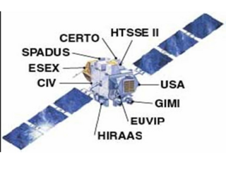
The Advanced Research and Global Observation Satellite (ARGOS) was launched on 23 February 1999 carrying nine payloads for research and development missions by nine separate researchers. The mission terminated on 31 July 2003.

<span class="mw-page-title-main">C/NOFS</span>

C/NOFS, or Communications/Navigation Outage Forecasting System was a USAF satellite developed by the Air Force Research Laboratory (AFRL) Space Vehicles Directorate to investigate and forecast scintillations in the Earth's ionosphere. It was launched by an Orbital Sciences Corporation Pegasus-XL launch vehicle at 17:02:48 UTC on 16 April 2008 and decayed on 28 November 2015.

<span class="mw-page-title-main">MAVEN</span> NASA Mars orbiter

MAVEN is a NASA spacecraft orbiting Mars to study the loss of that planet's atmospheric gases to space, providing insight into the history of the planet's climate and water. The name is an acronym for "Mars Atmosphere and Volatile Evolution" while the word maven also denotes "a person who has special knowledge or experience; an expert". MAVEN was launched on an Atlas V rocket from Cape Canaveral Air Force Station, Florida, on 18 November 2013 UTC and went into orbit around Mars on 22 September 2014 UTC. The mission is the first by NASA to study the Mars atmosphere. The probe is analyzing the planet's upper atmosphere and ionosphere to examine how and at what rate the solar wind is stripping away volatile compounds.

<span class="mw-page-title-main">Energetic neutral atom</span> Technology to create global images of otherwise invisible phenomena

Energetic Neutral Atom (ENA) imaging, often described as "seeing with atoms", is a technology used to create global images of otherwise invisible phenomena in the magnetospheres of planets and throughout the heliosphere.

<span class="mw-page-title-main">FASTSAT</span>

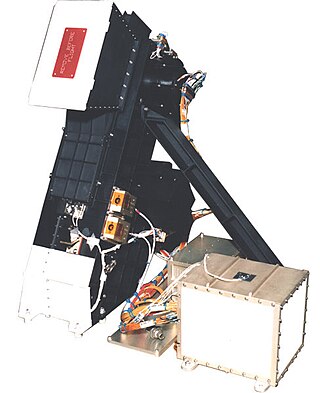
Fast, Affordable, Science and Technology Satellite-Huntsville 01 or FASTSAT-Huntsville 01 of the NASA. FASTSAT-HSV 01 was flying on the STP-S26 mission - a joint activity between NASA and the U.S. Department of Defense Space Test Program, or DoD STP. FASTSAT and all of its six experiments flying on the STP-S26 multi-spacecraft/payload mission have been approved by the Department of Defense Space and Experiments Review Board (USA-220).

<span class="mw-page-title-main">Global-scale Observations of the Limb and Disk</span>

Global-scale Observations of the Limb and Disk (GOLD) is a heliophysics Mission of Opportunity (MOU) for NASA's Explorers program. Led by Richard Eastes at the Laboratory for Atmospheric and Space Physics, which is located at the University of Colorado Boulder, GOLD's mission is to image the boundary between Earth and space in order to answer questions about the effects of solar and atmospheric variability of Earth's space weather. GOLD was one of 11 proposals selected, of the 42 submitted, for further study in September 2011. On 12 April 2013, NASA announced that GOLD, along with the Ionospheric Connection Explorer (ICON), had been selected for flight in 2017. GOLD, along with its commercial host satellite SES-14, launched on 25 January 2018.

Tandem Reconnection and Cusp Electrodynamics Reconnaissance Satellites (TRACERS) is a planned orbiter mission tasked to study the origins of the solar wind and how it affects Earth. The Principal Investigator is Craig Kletzing at the University of Iowa in Iowa City, Iowa. Not including rideshare costs, TRACERS is funded US$115 million.

<span class="mw-page-title-main">Dynamics Explorer 2</span> NASA satellite of the Explorer program

Dynamics Explorer 2 was a NASA low-altitude mission, launched on 3 August 1981. It consisted of two satellites, DE-1 and DE-2, whose purpose was to investigate the interactions between plasmas in the magnetosphere and those in the ionosphere. The two satellites were launched together into polar coplanar orbits, which allowed them to simultaneously observe the upper and lower parts of the atmosphere.

References

  1. "ICON: Exploring where Earth's Weather meets Space Weather" (PDF). University of California, Berekeley. Retrieved 4 February 2018.
  2. 1 2 ICON Factsheet Archived 24 October 2018 at the Wayback Machine , Northrop Grumman, Accessed: 24 October 2018
  3. 1 2 3 4 ICON, October 2018, NASA PD-icon.svg This article incorporates text from this source, which is in the public domain .
  4. 1 2 NASA Launches Long-Delayed ICON Space Weather Satellite to Study Earth's Ionosphere, Amy Thompson, Space.com, 11 October 2019
  5. 1 2 Granath, Bob (21 September 2018). "NASA's ICON launch now targeted for October 26 - ICON Mission". NASA. Retrieved 21 September 2018.PD-icon.svg This article incorporates text from this source, which is in the public domain .
  6. 1 2 "Ionospheric Connection Explorer". University of California, Berkeley.
  7. "ICON Mission Overview". NASA. 31 March 2016. Retrieved 4 February 2018.PD-icon.svg This article incorporates text from this source, which is in the public domain .
  8. Sanders, Robert (16 April 2013). "UC Berkeley selected to build NASA's next space weather satellite". Berkeley News. Retrieved 19 January 2016.
  9. 1 2 3 Harrington, J. D. (5 April 2013). "NASA Selects Explorer Investigations for Formulation". NASA. Retrieved 6 April 2013.PD-icon.svg This article incorporates text from this source, which is in the public domain .
  10. Leone, Dan (20 October 2015). "Heliophysics Small Explorer Solicitation Set for First Half of 2016". SpaceNews. Retrieved 21 October 2015.
  11. "ICON Project Management". University of California, Berkeley. Retrieved 14 October 2017.
  12. Bartels, Meghan (23 October 2018). "ICON of Delay? NASA, Northrop Grumman Postpone Earth Satellite Mission Yet Again". SPACE.com. Retrieved 9 March 2019.
  13. 1 2 3 Gebhardt, Chris (5 October 2018). "Northrop Grumman Innovation Systems updates ICON launch status". NASASpaceFlight.com. Retrieved 26 October 2018.
  14. Clark, Stephen (10 November 2017). "Launch of NASA ionospheric probe delayed to examine rocket issue". Spaceflight Now. Retrieved 26 October 2018.
  15. 1 2 "Ionospheric Connection Explorer (ICON) Satellite". Aerospace Technology. Retrieved 11 October 2018.
  16. "ICON (Ionospheric Connection Explorer) - Satellite Missions". directory.eoportal.org. Archived from the original on 4 August 2019. Retrieved 11 October 2018.
  17. 1 2 3 Englert, Christoph R.; Harlander, John M.; Brown, Charles M.; Marr, Kenneth D.; Miller, Ian J.; Stump, J. Eloise; Hancock, Jed; Peterson, James Q.; Kumler, Jay (20 April 2017). "Michelson Interferometer for Global High-Resolution Thermospheric Imaging (MIGHTI): Instrument Design and Calibration". Space Science Reviews. 212 (1–2): 553–584. Bibcode:2017SSRv..212..553E. doi:10.1007/s11214-017-0358-4. ISSN   0038-6308. PMC   6042234 . PMID   30008488.
  18. 1 2 Frazier, Sarah (18 October 2018). "Counting Down to the Ionospheric Connection Explorer (ICON) Launch". SciTechDaily. Retrieved 26 October 2018.
  19. Simon, Matt (17 October 2019). "UC Berkeley Was About to Launch a Satellite. Then PG&E Said It Was Cutting Power". Wired (San Francisco, Calif.). Wired. ISSN   1059-1028 . Retrieved 19 October 2019.
  20. "ICON Mission Out of Contact – ICON Mission". blogs.nasa.gov. 7 December 2022. Retrieved 9 December 2022.

Commons-logo.svg Media related to Ionospheric Connection Explorer at Wikimedia Commons