Fairfield is an small, rural, unincorporated village in northeastern Billings County, North Dakota, United States. It lies along U.S. Route 85, northeast of the city of Medora, the county seat of Billings County. It has a cafe, an elementary school, and the post office serving the ZIP code of 58627.
Hannover is an unincorporated community in central Oliver County, North Dakota, United States. It lies at the intersection of North Dakota Highways 25 and 31, west of the city of Center, the county seat of Oliver County.

Zahl is an unincorporated community in northwestern Williams County, North Dakota, United States. It lies along North Dakota Highway 50 north of the city of Williston, the county seat of Williams County.
Trenton is an unincorporated community and census-designated place (CDP) in northwestern Williams County, North Dakota, United States. It lies along North Dakota Highway 1804 southwest of the city of Williston, the county seat of Williams County. The community lies 220 miles north-west of Bismarck. It was first listed as a CDP prior to the 2020 census.
Roseglen is an unincorporated community in northwestern McLean County, North Dakota, United States. It lies along North Dakota Highway 37 northwest of the city of Washburn, the county seat of McLean County. Its elevation is 2,100 feet (640 m). Roseglen Township is served by the White Shield School District, which operates a K-12 public school program from one campus in Roseglen.

Norwich is an unincorporated community in western McHenry County, North Dakota, United States. It lies along U.S. Route 2 southwest of the city of Towner, the county seat of McHenry County. Norwich's elevation is 1,549 feet (472 m). It is unincorporated, and had a post office with the ZIP code of 58768. Though the post office closed May 4, 1996, the ZIP code is still valid for use.
Lefor is an unincorporated community in southern Stark County, North Dakota, United States. It lies southeast of the city of Dickinson, the county seat of Stark County. Its elevation is 2,592 feet (790 m). Lefor's post office closed November 2, 2002, but the town still has its own ZIP code of 58641.

Grassy Butte is an unincorporated community in southeastern McKenzie County, North Dakota, United States. It lies along U.S. Route 85, south of the city of Watford City, the county seat of McKenzie County.

St. Anthony or Saint Anthony is an unincorporated town in southeastern Morton County, North Dakota, United States. It lies a short distance to the west of North Dakota Highway 6, south of the city of Mandan, the county seat of Morton County. It has the ZIP code 58566. In 2018, the population was estimated to be less than 30.

Absaraka is an unincorporated community in central Cass County, North Dakota, United States. It lies northwest of the city of Fargo, the county seat of Cass County.

Arvilla is an unincorporated community in central Grand Forks County, North Dakota, United States. It lies along U.S. Route 2, west of the city of Grand Forks, the county seat of Grand Forks County. Its elevation is 1,004 feet (306 m). The community was first named Orange for Orange County, New York; it was renamed Arvilla for Arvilla Estella Hersey, the wife of a local farmer. Although Arvilla is unincorporated, it has a post office, with the ZIP code of 58214.
Mekinock is an unincorporated community in eastern Grand Forks County, North Dakota, United States. It lies northwest of the city of Grand Forks, the county seat of Grand Forks County. Mekinock's elevation is 860 feet (262 m). It has a post office with the ZIP code 58258.
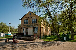
Saint Michael is an unincorporated community in southeastern Benson County, North Dakota, United States, on the Spirit Lake Dakota Reservation. It lies along North Dakota Highway 57 in Mission Township, southeast of the city of Minnewaukan, the county seat. It has a post office with the ZIP code 58370.
Penn is an unincorporated community in western Ramsey County, North Dakota, United States. It lies along U.S. Route 2, northwest of the city of Devils Lake, the county seat of Ramsey County. Its elevation is 1,467 feet (447 m). The community was first named Lauren for the townsite owner, Lauren, and was later renamed Penn for English stockholders. It has a post office with the ZIP code 58362.

Tokio is an unincorporated community in southeastern Benson County, North Dakota, United States, on the Spirit Lake Indian Reservation. It lies southeast of the city of Minnewaukan, the county seat of Benson County. It has a post office with the ZIP code 58379.

Menoken is an unincorporated community and a census-designated place (CDP) in southwestern Burleigh County, North Dakota, United States. It was designated as part of the U.S. Census Bureau's Participant Statistical Areas Program on June 10, 2010. It was not counted separately during the 2000 Census, but was included in the 2010 Census, where a population of 70 was reported.

Kintyre is an unincorporated community in northeastern Emmons County, North Dakota, United States. It lies northeast of the city of Linton, the county seat of Emmons County. The community was originally named Campbell for Dugald and Hugh Campbell, brothers who ranched there; it is now named Kintyre for the Kintyre Peninsula in Argyll, Scotland. It has a post office with the ZIP code 58549.
Webster is an unincorporated community in central Ramsey County, North Dakota, United States. It lies along North Dakota Highway 20 north of the city of Devils Lake, the county seat of Ramsey County. Its elevation is 1,467 feet (447 m). it had a post office, with the ZIP code 58382.

Chaseley is an unincorporated community in southwestern Wells County, North Dakota, United States. It lies along North Dakota Highway 200 southwest of the city of Fessenden, the county seat of Wells County. It formerly had a post office, with the ZIP code of 58423.

Beulah is a census-designated place (CDP) in eastern Crook County, Wyoming, United States, along Sand Creek, a tributary of the Belle Fourche River. According to local residents, the population is 33. When the 2010 census reported the population as 73, the highway sign at the town entrance was changed. In 2012, Beulah residents succeeded in appealing to the Wyoming Governor to remove the new sign and replace it with one that proclaimed the population to be 33.


