Related Research Articles


Franklin County is located in the U.S. state of Missouri. At the 2020 census, the population was 104,682. Its county seat is Union. The county was organized in 1818 and is named after Founding Father Benjamin Franklin.

Pacific is a city in the U.S. state of Missouri in eastern Franklin County and extending to the east into southwest St. Louis County. The population was 7,414 at the 2020 census.

Fanning is an unincorporated community in western Crawford County, Missouri, United States. It lies along former U.S. Route 66, now Missouri Supplemental Route ZZ, four miles southwest of Cuba. Fanning is also home to the world's second largest rocking chair, located outside of the Fanning 66 Outpost.
Chadwick is an unincorporated community in eastern Christian County, Missouri, United States. It is located approximately six miles southeast of Sparta along Missouri Route 125. The community of Oldfield is approximately three miles to the north along Route 125. It is part of the Springfield, Missouri Metropolitan Statistical Area. Its ZIP code is 65629.
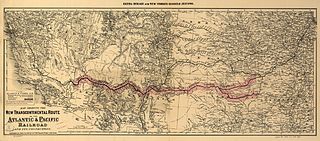
The Atlantic and Pacific Railroad was a U.S. railroad that owned or operated two disjointed segments, one connecting St. Louis, Missouri with Tulsa, Oklahoma, and the other connecting Albuquerque, New Mexico with Needles in Southern California. It was incorporated by the U.S. Congress in 1866 as a transcontinental railroad connecting Springfield, Missouri and Van Buren, Arkansas with California. The central portion was never constructed, and the two halves later became parts of the St. Louis-San Francisco Railway and Atchison, Topeka and Santa Fe Railway systems, now both merged into the BNSF Railway.
Cook Station is an unincorporated community in southwest Crawford County, Missouri, United States. It is located on the Meramec River, approximately ten miles south of Steelville, along Missouri Route M.
Dittmer is an unincorporated community in western Jefferson County, Missouri, United States. It is located on Route 30 southwest of Cedar Hill.
Robertsville is an unincorporated community in eastern Franklin County, Missouri, United States. It is located approximately six miles (10 km) southwest of Pacific on Missouri Route O and is home to the 1,225-acre (4.96 km2) Robertsville State Park.
Lonedell is an unincorporated community in southeastern Franklin County, Missouri, United States. It is at the intersection of Route 30 and routes N and FF and approximately eight miles east of St. Clair. The Little Meramac River flows just south of the community.
The Pacific Railroad was a railroad based in Missouri. It was a predecessor of both the Missouri Pacific Railroad and St. Louis-San Francisco Railway.
Anaconda is an unincorporated community in southern Franklin County, Missouri, United States. The community is southeast of Interstate 44, between St. Clair and Stanton.
Wingate is an unincorporated community in northeast Cass County, in the U.S. state of Missouri.
Hofflins is an unincorporated community in western Crawford County, in the U.S. state of Missouri. The community is adjacent to I-44 approximately three miles northeast of Cuba and Leasburg lies three miles to the east. The St. Louis and San Francisco Railroad line passes through the location.
Pennsboro is an unincorporated community in southern Dade County, in the U.S. state of Missouri.
Campbellton is an unincorporated community in northern Franklin County, in the U.S. state of Missouri. The community lies on Missouri Route 185 between Lyon to the southwest and Dundee to the northeast. Campbellton School is approximately 1.5 miles northeast on Route 185. Boeuf Creek drains the area to the north and the small stream, Slaughter Branch, flows past the village to the south.
Champion City is an unincorporated community in southwest Franklin County in the U.S. state of Missouri.
Winch Creek is a stream in eastern Franklin County in the U.S. state of Missouri. Winch Creek is a tributary to the Meramec River.
Rockingham is an unincorporated community in eastern Ray County, in the U.S. state of Missouri and part of the Kansas City metropolitan area.
Ojibway is an extinct town in southern Wayne County, in the U.S. state of Missouri. The community location lies adjacent to the Otter Creek arm of Lake Wappapello approximately one mile from the end of Missouri Route PP. Previous to the formation of the lake the community was along Otter Creek and the St. Louis and San Francisco Railroad line just west of Chaonia.
References
- ↑ Missouri Atlas & Gazetteer, DeLorme, 1998, First edition, p. 40 ISBN 0-89933-224-2
- ↑ Gray Summit, Missouri (1969), 7.5 Minute Topographic Quadrangle, USGS
- ↑ "Franklin County Place Names, 1928–1945 (archived)". The State Historical Society of Missouri. Archived from the original on 24 June 2016. Retrieved 29 September 2016.
{{cite web}}: CS1 maint: bot: original URL status unknown (link) - ↑ "Post Offices". Jim Forte Postal History. Archived from the original on 6 October 2014. Retrieved 29 September 2016.
