Related Research Articles

Grubville is an unincorporated community in western Jefferson County, Missouri, United States. It is located approximately one-half mile east of the Jefferson/Franklin County line. Missouri routes WW and Y meet at the community and Route 30 passes approximately one mile to the north. Nearby communities include Dittmer and Morse Mill to the east and Lonedell and Luebbering to the west in Franklin County. Jones Creek flows from the east side of the community to its confluence with Big River approximately five miles to the east.
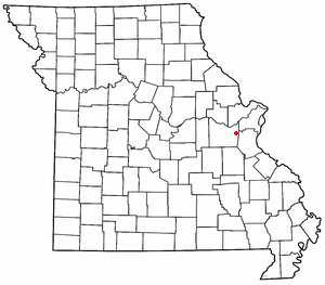
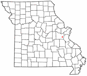
Robertsville is an unincorporated community in eastern Franklin County, Missouri, United States. It is located approximately six miles (10 km) southwest of Pacific on Missouri Route O and is home to the 1,225-acre (4.96 km2) Robertsville State Park.

Moselle is an unincorporated community in Franklin County, Missouri, United States. It is located approximately five miles northeast of St. Clair.
Lonedell is an unincorporated community in southeastern Franklin County, Missouri, United States. It is at the intersection of Route 30 and routes N and FF and approximately eight miles east of St. Clair. The Little Meramac River flows just south of the community.

Luebbering is an unincorporated community in eastern Franklin County, Missouri, United States. It is located on Missouri Route FF, approximately ten miles southeast of St. Clair and about 2.5 miles south of Lonedell.
Boles is an unincorporated community in northern Franklin County, in the U.S. state of Missouri.
Calvey is an extinct town in Franklin County, in the U.S. state of Missouri.
Clover Bottom is an unincorporated community in Franklin County, in the U.S. state of Missouri. The community is at the intersection of routes YY and AJ approximately 3.5 miles west of Krakow.
George is an extinct town in Franklin County, in the U.S. state of Missouri.
Hemker (Hemkerville) was an unincorporated community in Franklin County, in the U.S. state of Missouri, but was dissolved in 1970 after the last residents moved out. The community is now considered part of Robertsville, MO.
Huff is an unincorporated community in Franklin County, in the U.S. state of Missouri.
Jeffriesburg is an unincorporated community in Franklin County, in the U.S. state of Missouri.
Kiel is an unincorporated community in northwest Franklin County, in the U.S. state of Missouri.
Krakow is an unincorporated community in Franklin County, in the U.S. state of Missouri. The community is situated on Missouri Route A, between Union to the south and Washington to the north.
Lyon is an unincorporated community in Franklin County, in the U.S. state of Missouri.
Maupin is an unincorporated community in Franklin County, in the U.S. state of Missouri.
Monday is an unincorporated community in Franklin County, in the U.S. state of Missouri.
Mount Hope (also spelled is an unincorporated community in southeastern Franklin County, in the U.S. state of Missouri.
Oetters is an unincorporated community in Franklin County, in the U.S. state of Missouri. The community sits above the Missouri River floodplain along Missouri Route T. Fiddle Creek passes adjacent to the community as it enters the Missouri River floodplain.
Port Hudson is an unincorporated community in western Franklin County, in the U.S. state of Missouri. The community is on Missouri Route C and approximately two miles north of Leslie and US Route 50.
References
- ↑ U.S. Geological Survey Geographic Names Information System: Gildehouse, Missouri
- ↑ "Post Offices". Jim Forte Postal History. Archived from the original on 6 October 2014. Retrieved 30 September 2016.
- ↑ "Franklin County Place Names, 1928–1945 (archived)". The State Historical Society of Missouri. Archived from the original on 24 June 2016. Retrieved 30 September 2016.
{{cite web}}: CS1 maint: bot: original URL status unknown (link)
Municipalities and communities of Franklin County, Missouri, United States | ||
|---|---|---|
| Cities |  | |
| Villages | ||
| Townships | ||
| CDPs | ||
| Other communities |
| |
| Ghost towns | ||
| Footnotes | ‡This populated place also has portions in an adjacent county or counties | |
38°29′05″N90°56′19″W / 38.48472°N 90.93861°W
| | This Franklin County, Missouri state location article is a stub. You can help Wikipedia by expanding it. |