The North American Plate is a tectonic plate covering most of North America, Cuba, the Bahamas, extreme northeastern Asia, and parts of Iceland and the Azores. With an area of 76 million km2 (29 million sq mi), it is the Earth's second largest tectonic plate, behind the Pacific Plate.

The Cocos Plate is a young oceanic tectonic plate beneath the Pacific Ocean off the west coast of Central America, named for Cocos Island, which rides upon it. The Cocos Plate was created approximately 23 million years ago when the Farallon Plate broke into two pieces, which also created the Nazca Plate. The Cocos Plate also broke into two pieces, creating the small Rivera Plate. The Cocos Plate is bounded by several different plates. To the northeast it is bounded by the North American Plate and the Caribbean Plate. To the west it is bounded by the Pacific Plate and to the south by the Nazca Plate.

The Scotia Plate is a tectonic plate on the edge of the South Atlantic and Southern oceans. Thought to have formed during the early Eocene with the opening of the Drake Passage that separates South America from Antarctica, it is a minor plate whose movement is largely controlled by the two major plates that surround it: the South American Plate and the Antarctic Plate. The Scotia Plate takes its name from the steam yacht Scotia of the Scottish National Antarctic Expedition (1902–04), the expedition that made the first bathymetric study of the region.

The Caribbean Plate is a mostly oceanic tectonic plate underlying Central America and the Caribbean Sea off the northern coast of South America.

The Middle America Trench is a major subduction zone, an oceanic trench in the eastern Pacific Ocean off the southwestern coast of Middle America, stretching from central Mexico to Costa Rica. The trench is 1,700 miles (2,750 km) long and is 21,880 feet at its deepest point. The trench is the boundary between the Rivera, Cocos, and Nazca plates on one side and the North American and Caribbean plates on the other. It is the 18th-deepest trench in the world. Many large earthquakes have occurred in the area of the Middle America Trench.

The Kermadec-Tonga subduction zone is a convergent plate boundary that stretches from the North Island of New Zealand northward. The formation of the Kermadec and Tonga Plates started about 4–5 million years ago. Today, the eastern boundary of the Tonga Plate is one of the fastest subduction zones, with a rate up to 24 cm/yr. The trench formed between the Kermadec-Tonga and Pacific Plates is also home to the second deepest trench in the world, at about 10,800 m, as well as the longest chain of submerged volcanoes.

The Motagua Fault is a major, active left lateral-moving transform fault which cuts across Guatemala. It forms part of the tectonic boundary between the North American Plate and the Caribbean Plate. It is considered the onshore continuation of the Swan Islands Transform Fault and Cayman trench, which run under the Caribbean Sea. Its western end appears not to continue further than its surface trace, where it is covered by Cenozoic volcanics.

The Juan Fernandez Plate is a microplate in the Pacific Ocean. With a surface area of approximately 105 km2, the microplate is located between 32° and 35°S and 109° and 112°W. The plate is located at a triple junction between the Pacific Plate, Antarctic Plate, and Nazca Plate. Approximately 2000 km to the west of South America, it is, on average, 3000 meters deep with its shallowest point coming to approximately 1600 meters, and its deepest point reaching 4400 meters.

The Mariana Plate is a micro tectonic plate located west of the Mariana Trench which forms the basement of the Mariana Islands which form part of the Izu–Bonin–Mariana Arc. It is separated from the Philippine Sea Plate to the west by a divergent boundary with numerous transform fault offsets. The boundary between the Mariana and the Pacific Plate to the east is a subduction zone with the Pacific Plate subducting beneath the Mariana. This eastern subduction is divided into the Mariana Trench, which forms the southeastern boundary, and the Izu–Ogasawara Trench the northeastern boundary. The subduction plate motion is responsible for the shape of the Mariana plate and back arc.
The Chixoy-Polochic Fault, also known as Cuilco-Chixoy-Polochic Fault, is a major fault zone in Guatemala and southeast Mexico. It runs in a light arc from the east coast of Guatemala to Chiapas, following the deep valleys of the Polochic River, Chixoy River and Cuilco River.

The Woodlark Plate is a small almost triangular shaped tectonic plate located east of the island of New Guinea. It is located in a very complex tectonic environment, that because of associated features, has been extensively studied since it was first proposed to exist. It is now known to be much smaller than originally proposed, mainly because of information from GPS stations on islands and sea floor studies that have fully defined its margins.

The Enriquillo–Plantain Garden fault zone is a system of active coaxial left lateral-moving strike slip faults which runs along the southern side of the island of Hispaniola, where Haiti and the Dominican Republic are located. The EPGFZ is named for Lake Enriquillo in the Dominican Republic where the fault zone emerges, and extends across the southern portion of Hispaniola through the Caribbean to the region of the Plantain Garden River in Jamaica.
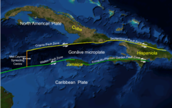
The Septentrional-Orient fault zone (SOFZ) is a system of active coaxial left lateral-moving strike slip faults that runs along the northern side of the island of Hispaniola where Haiti and the Dominican Republic are located and continues along the south of Cuba along the northern margin of the Cayman Trough. The SOFZ shares approximately half of the relative motion between the North American and Caribbean tectonic plates with the Enriquillo-Plantain Garden fault zone and Walton fault zone which run along the southern side of Hispaniola and aong the southern margin of the Cayman Trough. Both fault zones terminate at the Mid-Cayman Rise to the west. Some researchers believe that the Enriquillo-Plantain Garden fault zone and the SOFZ bound a microplate, dubbed the Gonâve Microplate, a 190,000 km2 (73,000 sq mi) area of the northern Caribbean Plate that is in the process of shearing off the Caribbean Plate and accreting to the North America Plate.
The Gonâve Microplate forms part of the boundary between the North American Plate and the Caribbean Plate. It is bounded to the west by the Mid-Cayman Rise spreading center, to the north by the Septentrional-Oriente fault zone and to the south by the Walton fault zone and the Enriquillo–Plantain Garden fault zone. The existence of this microplate was first proposed in 1991. This has been confirmed by GPS measurements, which show that the overall displacement between the two main plates is split almost equally between the transform fault zones that bound the Gonâve microplate. The microplate is expected to eventually become accreted to the North American Plate.
The Geology of Jamaica is formed of rocks of Cretaceous to Neogene age. The basement consists of Cretaceous island arc and back-arc basin sequences that formed above a subduction zone. The cover is of mainly Eocene to Miocene shallow water limestones, that have been uplifted due to the presence of a restraining bend along the major strike-slip faults that bound the southern edge of the Gonâve Microplate to the north of the island.

The Pacific Ocean evolved in the Mesozoic from the Panthalassic Ocean, which had formed when Rodinia rifted apart around 750 Ma. The first ocean floor which is part of the current Pacific Plate began 160 Ma to the west of the central Pacific and subsequently developed into the largest oceanic plate on Earth.
The Woodlark Basin is a young geologic structural basin located in the southwestern Pacific Ocean, found to the southeast of the island country of Papua New Guinea. The basin is an extensional basin that is actively spreading and has a seafloor spreading center. This basin formed between the Indo-Australian Plate and the Solomon microplate. The Woodlark Basin has an interesting and complex geologic history dating back twenty million years to the initial opening of the basin but most of the spreading has happened in the last 3.6 million years.
The Mid-Cayman Rise or Mid-Cayman Spreading Center is a relatively short divergent plate boundary in the middle of the Cayman Trough. It forms part of a dominantly transform boundary that is part of the southern margin to the North American Plate. It is an ultra-slow spreading center with an opening rate of 15–17 mm per year.
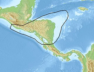
The Chortis Block is a 400–600 km (250–370 mi)-wide continental fragment in Central America located in the northwest corner of the oceanic Caribbean Plate.

At 2:10 p.m. local time (UTC-5) on 28 January 2020, an earthquake of 7.7 struck on the north side of the Cayman Trough, north of Jamaica and west of the southern tip of Cuba, with the epicenter being 80 miles (130 km) ESE of Cayman Brac, Cayman Islands or 83 miles (134 km) north of Montego Bay, Jamaica. Schools in Jamaica and buildings in Miami were evacuated after shaking was observed in parts of the U.S. state of Florida. Light shaking was also reported on the Yucatan peninsula in Mexico. It is the largest earthquake in the Caribbean since 1946. A tsunami warning for the Caribbean Sea was issued by the Pacific Tsunami Warning Center and later withdrawn.