Transform fault

Last updated
Diagram showing a transform fault with two plates moving in opposite directions Continental-continental conservative plate boundary opposite directions.svg
Diagram showing a transform fault with two plates moving in opposite directions
Transform fault (the red lines) Transform fault-1.svg
Transform fault (the red lines)

A transform fault or transform boundary, is a fault along a plate boundary where the motion is predominantly horizontal. [1] It ends abruptly where it connects to another plate boundary, either another transform, a spreading ridge, or a subduction zone. [2] A transform fault is a special case of a strike-slip fault that also forms a plate boundary.

Contents

Most such faults are found in oceanic crust, where they accommodate the lateral offset between segments of divergent boundaries, forming a zigzag pattern. This is a result of oblique seafloor spreading where the direction of motion is not perpendicular to the trend of the overall divergent boundary. A smaller number of such faults are found on land, although these are generally better-known, such as the San Andreas Fault and North Anatolian Fault.

Nomenclature

Transform boundaries are also known as conservative plate boundaries because they involve no addition or loss of lithosphere at the Earth's surface. [3]

Background

Geophysicist and geologist John Tuzo Wilson recognized that the offsets of oceanic ridges by faults do not follow the classical pattern of an offset fence or geological marker in Reid's rebound theory of faulting, [4] from which the sense of slip is derived. The new class of faults, [5] called transform faults, produce slip in the opposite direction from what one would surmise from the standard interpretation of an offset geological feature. Slip along transform faults does not increase the distance between the ridges it separates; the distance remains constant in earthquakes because the ridges are spreading centers. This hypothesis was confirmed in a study of the fault plane solutions that showed the slip on transform faults points in the opposite direction than classical interpretation would suggest. [6]

Difference between transform and transcurrent faults

Transform fault.svg
Transform fault
Transcurrent NEW.svg
Transcurrent fault

Transform faults are closely related to transcurrent faults and are commonly confused. Both types of fault are strike-slip or side-to-side in movement; nevertheless, transform faults always end at a junction with another plate boundary, while transcurrent faults may die out without a junction with another fault. Finally, transform faults form a tectonic plate boundary, while transcurrent faults do not.

Mechanics

Faults in general are focused areas of deformation or strain, which are the response of built-up stresses in the form of compression, tension, or shear stress in rock at the surface or deep in the Earth's subsurface. Transform faults specifically accommodate lateral strain by transferring displacement between mid-ocean ridges or subduction zones. They also act as the plane of weakness, which may result in splitting in rift zones.[ citation needed ]

Transform faults and divergent boundaries

Transform faults are commonly found linking segments of divergent boundaries (mid-oceanic ridges or spreading centres). These mid-oceanic ridges are where new seafloor is constantly created through the upwelling of new basaltic magma. With new seafloor being pushed and pulled out, the older seafloor slowly slides away from the mid-oceanic ridges toward the continents. Although separated only by tens of kilometers, this separation between segments of the ridges causes portions of the seafloor to push past each other in opposing directions. This lateral movement of seafloors past each other is where transform faults are currently active.

Spreading center and strips Spreading center and strips.png
Spreading center and strips

Transform faults move differently from a strike-slip fault at the mid-oceanic ridge. Instead of the ridges moving away from each other, as they do in other strike-slip faults, transform-fault ridges remain in the same, fixed locations, and the new ocean seafloor created at the ridges is pushed away from the ridge. Evidence of this motion can be found in paleomagnetic striping on the seafloor.

A paper written by geophysicist Taras Gerya theorizes that the creation of the transform faults between the ridges of the mid-oceanic ridge is attributed to rotated and stretched sections of the mid-oceanic ridge. [7] This occurs over a long period of time with the spreading center or ridge slowly deforming from a straight line to a curved line. Finally, fracturing along these planes forms transform faults. As this takes place, the fault changes from a normal fault with extensional stress to a strike-slip fault with lateral stress. [8] In the study done by Bonatti and Crane,[ who? ] peridotite and gabbro rocks were discovered in the edges of the transform ridges. These rocks are created deep inside the Earth's mantle and then rapidly exhumed to the surface. [8] This evidence helps to prove that new seafloor is being created at the mid-oceanic ridges and further supports the theory of plate tectonics.

Active transform faults are between two tectonic structures or faults. Fracture zones represent the previously active transform-fault lines, which have since passed the active transform zone and are being pushed toward the continents. These elevated ridges on the ocean floor can be traced for hundreds of miles and in some cases even from one continent across an ocean to the other continent.

Types

In his work on transform-fault systems, geologist Tuzo Wilson said that transform faults must be connected to other faults or tectonic-plate boundaries on both ends; because of that requirement, transform faults can grow in length, keep a constant length, or decrease in length. [5] These length changes are dependent on which type of fault or tectonic structure connect with the transform fault. Wilson described six types of transform faults:

Growing length: In situations where a transform fault links a spreading center and the upper block of a subduction zone or where two upper blocks of subduction zones are linked, the transform fault itself will grow in length. [5]

Spreading to upper NEW.svg Upper to upper.svg

Constant length: In other cases, transform faults will remain at a constant length. This steadiness can be attributed to many different causes. In the case of ridge-to-ridge transforms, the constancy is caused by the continuous growth by both ridges outward, canceling any change in length. The opposite occurs when a ridge linked to a subducting plate, where all the lithosphere (new seafloor) being created by the ridge is subducted, or swallowed up, by the subduction zone. [5] Finally, when two upper subduction plates are linked there is no change in length. This is due to the plates moving parallel with each other and no new lithosphere is being created to change that length.

Spreading centers constant.svg Upper to down NEW.svg

Decreasing length faults: In rare cases, transform faults can shrink in length. These occur when two descending subduction plates are linked by a transform fault. In time as the plates are subducted, the transform fault will decrease in length until the transform fault disappears completely, leaving only two subduction zones facing in opposite directions. [5]

Down to down NEW.svg Spreading to Down NEW.svg

Examples

Map of Earth's principal plates (transform boundaries shown as yellow or green lines) Tectonic plates (2022).svg
Map of Earth's principal plates (transform boundaries shown as yellow or green lines)

The most prominent examples of the mid-oceanic ridge transform zones are in the Atlantic Ocean between South America and Africa. Known as the St. Paul, Romanche, Chain, and Ascension fracture zones, these areas have deep, easily identifiable transform faults and ridges. Other locations include: the East Pacific Ridge located in the South Eastern Pacific Ocean, which meets up with San Andreas Fault to the North.

Transform faults are not limited to oceanic crust and spreading centers; many of them are on continental margins. The best example is the San Andreas Fault on the Pacific coast of the United States. The San Andreas Fault links the East Pacific Rise off the West coast of Mexico (Gulf of California) to the Mendocino Triple Junction (Part of the Juan de Fuca plate) off the coast of the Northwestern United States, making it a ridge-to-transform-style fault. [5] The formation of the San Andreas Fault system occurred fairly recently during the Oligocene Period between 34 million and 24 million years ago. [9] During this period, the Farallon plate, followed by the Pacific plate, collided into the North American plate. [9] The collision led to the subduction of the Farallon plate underneath the North American plate. Once the spreading center separating the Pacific and the Farallon plates was subducted beneath the North American plate, the San Andreas Continental Transform-Fault system was created. [9]

The Southern Alps rise dramatically beside the Alpine Fault on New Zealand's West Coast. About 500 kilometres (300 mi) long; northwest at top. Alpine Fault SRTM.jpg
The Southern Alps rise dramatically beside the Alpine Fault on New Zealand's West Coast. About 500 kilometres (300 mi) long; northwest at top.

In New Zealand, the South Island's alpine fault is a transform fault for much of its length. This has resulted in the folded land of the Southland Syncline being split into an eastern and western section several hundred kilometres apart. The majority of the syncline is found in Southland and The Catlins in the island's southeast, but a smaller section is also present in the Tasman District in the island's northwest.

Other examples include:

See also

Related Research Articles

<span class="mw-page-title-main">Plate tectonics</span> Movement of Earths lithosphere

Plate tectonics is the scientific theory that Earth's lithosphere comprises a number of large tectonic plates, which have been slowly moving since about 3.4 billion years ago. The model builds on the concept of continental drift, an idea developed during the first decades of the 20th century. Plate tectonics came to be accepted by geoscientists after seafloor spreading was validated in the mid-to-late 1960s.

<span class="mw-page-title-main">Subduction</span> A geological process at convergent tectonic plate boundaries where one plate moves under the other

Subduction is a geological process in which the oceanic lithosphere and some continental lithosphere is recycled into the Earth's mantle at convergent boundaries. Where the oceanic lithosphere of a tectonic plate converges with the less dense lithosphere of a second plate, the heavier plate dives beneath the second plate and sinks into the mantle. A region where this process occurs is known as a subduction zone, and its surface expression is known as an arc-trench complex. The process of subduction has created most of the Earth's continental crust. Rates of subduction are typically measured in centimeters per year, with rates of convergence as high as 11 cm/year.

<span class="mw-page-title-main">Basin and Range Province</span> Physiographic region extending through western United States and Mexico

The Basin and Range Province is a vast physiographic region covering much of the inland Western United States and northwestern Mexico. It is defined by unique basin and range topography, characterized by abrupt changes in elevation, alternating between narrow faulted mountain chains and flat arid valleys or basins. The physiography of the province is the result of tectonic extension that began around 17 million years ago in the early Miocene epoch.

<span class="mw-page-title-main">Divergent boundary</span> Linear feature that exists between two tectonic plates that are moving away from each other

In plate tectonics, a divergent boundary or divergent plate boundary is a linear feature that exists between two tectonic plates that are moving away from each other. Divergent boundaries within continents initially produce rifts, which eventually become rift valleys. Most active divergent plate boundaries occur between oceanic plates and exist as mid-oceanic ridges.

<span class="mw-page-title-main">Convergent boundary</span> Region of active deformation between colliding tectonic plates

A convergent boundary is an area on Earth where two or more lithospheric plates collide. One plate eventually slides beneath the other, a process known as subduction. The subduction zone can be defined by a plane where many earthquakes occur, called the Wadati–Benioff zone. These collisions happen on scales of millions to tens of millions of years and can lead to volcanism, earthquakes, orogenesis, destruction of lithosphere, and deformation. Convergent boundaries occur between oceanic-oceanic lithosphere, oceanic-continental lithosphere, and continental-continental lithosphere. The geologic features related to convergent boundaries vary depending on crust types.

<span class="mw-page-title-main">Tectonics</span> Process of evolution of the earths crust

Tectonics are the processes that result in the structure and properties of the Earth's crust and its evolution through time.

<span class="mw-page-title-main">North American Plate</span> Large tectonic plate including most of North America, Greenland and part of Siberia

The North American Plate is a tectonic plate containing most of North America, Cuba, the Bahamas, extreme northeastern Asia, and parts of Iceland and the Azores. With an area of 76 million km2 (29 million sq mi), it is the Earth's second largest tectonic plate, behind the Pacific Plate.

<span class="mw-page-title-main">Juan de Fuca Plate</span> Small tectonic plate in the eastern North Pacific

The Juan de Fuca Plate is a small tectonic plate (microplate) generated from the Juan de Fuca Ridge that is subducting beneath the northerly portion of the western side of the North American Plate at the Cascadia subduction zone. It is named after the explorer of the same name. One of the smallest of Earth's tectonic plates, the Juan de Fuca Plate is a remnant part of the once-vast Farallon Plate, which is now largely subducted underneath the North American Plate.

<span class="mw-page-title-main">Fracture zone</span> Linear feature on the ocean floor

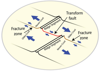
A fracture zone is a linear feature on the ocean floor—often hundreds, even thousands of kilometers long—resulting from the action of offset mid-ocean ridge axis segments. They are a consequence of plate tectonics. Lithospheric plates on either side of an active transform fault move in opposite directions; here, strike-slip activity occurs. Fracture zones extend past the transform faults, away from the ridge axis; are usually seismically inactive, although they can display evidence of transform fault activity, primarily in the different ages of the crust on opposite sides of the zone.

<span class="mw-page-title-main">Triple junction</span> Meeting point of three tectonic plates

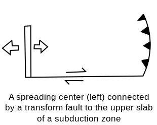
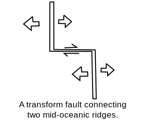
A triple junction is the point where the boundaries of three tectonic plates meet. At the triple junction each of the three boundaries will be one of three types – a ridge (R), trench (T) or transform fault (F) – and triple junctions can be described according to the types of plate margin that meet at them. Of the ten possible types of triple junctions only a few are stable through time. The meeting of four or more plates is also theoretically possible but junctions will only exist instantaneously.

<span class="mw-page-title-main">Mid-ocean ridge</span> Basaltic underwater mountain system formed by plate tectonic spreading

A mid-ocean ridge (MOR) is a seafloor mountain system formed by plate tectonics. It typically has a depth of about 2,600 meters (8,500 ft) and rises about 2,000 meters (6,600 ft) above the deepest portion of an ocean basin. This feature is where seafloor spreading takes place along a divergent plate boundary. The rate of seafloor spreading determines the morphology of the crest of the mid-ocean ridge and its width in an ocean basin.

<span class="mw-page-title-main">Submarine earthquake</span> Earthquake that occurs under a body of water, especially an ocean

A submarine, undersea, or underwater earthquake is an earthquake that occurs underwater at the bottom of a body of water, especially an ocean. They are the leading cause of tsunamis. The magnitude can be measured scientifically by the use of the moment magnitude scale and the intensity can be assigned using the Mercalli intensity scale.

<span class="mw-page-title-main">Explorer Ridge</span> Mid-ocean ridge west of British Columbia, Canada

The Explorer Ridge is a mid-ocean ridge, a divergent tectonic plate boundary located about 241 km (150 mi) west of Vancouver Island, British Columbia, Canada. It lies at the northern extremity of the Pacific spreading axis. To its east is the Explorer Plate, which together with the Juan de Fuca Plate and the Gorda Plate to its south, is what remains of the once-vast Farallon Plate which has been largely subducted under the North American Plate. The Explorer Ridge consists of one major segment, the Southern Explorer Ridge, and several smaller segments. It runs northward from the Sovanco Fracture Zone to the Queen Charlotte Triple Junction, a point where it meets the Queen Charlotte Fault and the northern Cascadia subduction zone.

<span class="mw-page-title-main">Izu–Bonin–Mariana Arc</span> Convergent boundary in Micronesia

The Izu–Bonin–Mariana (IBM) arc system is a tectonic plate convergent boundary in Micronesia. The IBM arc system extends over 2800 km south from Tokyo, Japan, to beyond Guam, and includes the Izu Islands, the Bonin Islands, and the Mariana Islands; much more of the IBM arc system is submerged below sealevel. The IBM arc system lies along the eastern margin of the Philippine Sea Plate in the Western Pacific Ocean. It is the site of the deepest gash in Earth's solid surface, the Challenger Deep in the Mariana Trench.

<span class="mw-page-title-main">Macquarie Triple Junction</span> Place where the Indo-Australian Plate, Pacific Plate, and Antarctic Plate meet

The Macquarie Triple Junction is a geologically active tectonic boundary located at 61°30′S161°0′E at which the historic Indo-Australian Plate, Pacific Plate, and Antarctic Plate collide and interact. The term Triple Junction is given to particular tectonic boundaries at which three separate tectonic plates meet at a specific, singular location. The Macquarie Triple Junction is located on the seafloor of the southern region of the Pacific Ocean, just south of New Zealand. This tectonic boundary was named in respect to the nearby Macquarie Island, which is located southeast of New Zealand.

<span class="mw-page-title-main">Macquarie Fault Zone</span> Lateral-moving transform fault south of New Zealand

The 1,600 kilometres (990 mi) long Macquarie Fault Zone is a major right lateral-moving transform fault along the seafloor of the south Pacific Ocean which runs from New Zealand southwestward towards the Macquarie Triple Junction. It is also the tectonic plate boundary between the Australian Plate to the northwest and the Pacific Plate to the southeast. As such it is a region of high seismic activity and recorded the largest strike-slip event on record up to May 23, 1989, of at least Mw8.0

This is a list of articles related to plate tectonics and tectonic plates.

The Hjort Trench is a linear topographic depression south of Macquarie Island in the southwest Pacific Ocean. Geologically, the depression is considered to be the seafloor expression of an ocean-ocean subduction zone, where the Australian plate is thrusting beneath the Pacific Plate. As the southernmost portion of the Macquarie Ridge Complex, the Hjort Trench lies in an area of diagonal convergence produced by the transform fault evolution of the Emerald Fracture Zone. Frequent seismic events, most less than 20 km (12 mi) deep, characterize the transpression along this plate boundary.

<span class="mw-page-title-main">Chile Ridge</span> Submarine oceanic ridge in the Pacific Ocean

The Chile Ridge, also known as the Chile Rise, is a submarine oceanic ridge formed by the divergent plate boundary between the Nazca Plate and the Antarctic Plate. It extends from the triple junction of the Nazca, Pacific, and Antarctic plates to the Southern coast of Chile. The Chile Ridge is easy to recognize on the map, as the ridge is divided into several segmented fracture zones which are perpendicular to the ridge segments, showing an orthogonal shape toward the spreading direction. The total length of the ridge segments is about 550–600 km.

Magmatism along strike-slip faults is the process of rock melting, magma ascent and emplacement, associated with the tectonics and geometry of various strike-slip settings, most commonly occurring along transform boundaries at mid-ocean ridge spreading centres and at strike-slip systems parallel to oblique subduction zones. Strike-slip faults have a direct effect on magmatism. They can either induce magmatism, act as a conduit to magmatism and magmatic flow, or block magmatic flow. In contrast, magmatism can also directly impact on strike-slip faults by determining fault formation, propagation and slip. Both magma and strike-slip faults coexist and affect one another.

References

  1. Moores E.M.; Twiss R.J. (2014). Tectonics. Waveland Press. p. 130. ISBN   978-1-4786-2660-2.
  2. Kearey, K. A. (2007). Global Tectonics. Hoboken, NJ, USA: John Wiley & Sons. pp. 84–90.
  3. "Plate Tectonics". British Geological Survey. 2020. Retrieved 16 February 2020.
  4. Reid, H.F., (1910). The Mechanics of the Earthquake. in The California Earthquake of April 18, 1906, Report of the State Earthquake Investigation Commission, Carnegie Institution of Washington, Washington D.C.
  5. 1 2 3 4 5 6 Wilson, J.T. (24 July 1965). "A new class of faults and their bearing on continental drift". Nature. 207 (4995): 343–347. Bibcode:1965Natur.207..343W. doi:10.1038/207343a0. S2CID   4294401.
  6. Sykes, L.R. (1967). Mechanism of earthquakes and nature of faulting on the mid-oceanic ridges, Journal of Geophysical Research, 72, 5–27.
  7. Gerya, T. (2010). "Dynamical Instability Produces Transform Faults at Mid-Ocean Ridges". Science. 329 (5995): 1047–1050. Bibcode:2010Sci...329.1047G. doi:10.1126/science.1191349. PMID   20798313. S2CID   10943308.
  8. 1 2 Bonatti, Enrico; Crane, Kathleen (1984). "Oceanic Fracture Zones". Scientific American. 250 (5): 40–52. Bibcode:1984SciAm.250e..40B. doi:10.1038/scientificamerican0584-40.
  9. 1 2 3 Atwater, Tanya (1970). "Implications of Plate Tectonics for the Cenozoic Tectonic Evolution of Western North America". Bulletin of the Geological Society of America. 81 (12): 3513–3536. Bibcode:1970GSAB...81.3513A. doi:10.1130/0016-7606(1970)81[3513:ioptft]2.0.co;2.