Tidal bore

Last updated

A bore in Morecambe Bay, in the United Kingdom Tidal Bore - geograph.org.uk - 324581.jpg
A bore in Morecambe Bay, in the United Kingdom
Video of the Arnside Bore, in the United Kingdom
The tidal bore in Upper Cook Inlet, in Alaska Turnagain-bore.jpg
The tidal bore in Upper Cook Inlet, in Alaska

A tidal bore, [1] often simply given as bore in context, is a tidal phenomenon in which the leading edge of the incoming tide forms a wave (or waves) of water that travels up a river or narrow bay, reversing the direction of the river or bay's current. It is a strong tide that pushes up the river, against the current.

Contents

Description

Bores occur in relatively few locations worldwide, usually in areas with a large tidal range (typically more than 6 meters (20 ft) between high and low tide) and where incoming tides are funneled into a shallow, narrowing river or lake via a broad bay. [2] The funnel-like shape not only increases the tidal range, but it can also decrease the duration of the flood tide, down to a point where the flood appears as a sudden increase in the water level. A tidal bore takes place during the flood tide and never during the ebb tide.

Undular bore and whelps near the mouth of Araguari River in northeastern Brazil. The view is oblique towards the mouth from airplane at approximately 30 m (100 ft) altitude. Undular bore Araguari River-Brazil-USGS-bws00026.jpg
Undular bore and whelps near the mouth of Araguari River in northeastern Brazil. The view is oblique towards the mouth from airplane at approximately 30 m (100 ft) altitude.

A tidal bore may take on various forms, ranging from a single breaking wavefront with a roller – somewhat like a hydraulic jump [4] [5] – to undular bores, comprising a smooth wavefront followed by a train of secondary waves known as whelps. [6] Large bores can be particularly unsafe for shipping but also present opportunities for river surfing. [6]

Two key features of a tidal bore are the intense turbulence and turbulent mixing generated during the bore propagation, as well as its rumbling noise. The visual observations of tidal bores highlight the turbulent nature of the surging waters. The tidal bore induces a strong turbulent mixing in the estuarine zone, and the effects may be felt along considerable distances. The velocity observations indicate a rapid deceleration of the flow associated with the passage of the bore as well as large velocity fluctuations. [7] [8] A tidal bore creates a powerful roar that combines the sounds caused by the turbulence in the bore front and whelps, entrained air bubbles in the bore roller, sediment erosion beneath the bore front and of the banks, scouring of shoals and bars, and impacts on obstacles. The bore rumble is heard far away because its low frequencies can travel over long distances. The low-frequency sound is a characteristic feature of the advancing roller in which the air bubbles entrapped in the large-scale eddies are acoustically active and play the dominant role in the rumble-sound generation. [9]

Etymology

The word bore derives through Old English from the Old Norse word bára, meaning "wave" or "swell."

Effects

Tidal bores can be dangerous. Certain rivers such as the Seine in France, the Petitcodiac River in Canada, and the Colorado River in Mexico to name a few, have had a sinister reputation in association with tidal bores. In China, despite warning signs erected along the banks of the Qiantang River, a number of fatalities occur each year by people who take too much risk with the bore. [2] The tidal bores affect the shipping and navigation in the estuarine zone, for example, in Papua New Guinea (in the Fly and Bamu Rivers), Malaysia (the Benak in the Batang Lupar), and India (the Hooghly River bore).

On the other hand, tidal bore-affected estuaries are rich feeding zones and breeding grounds of several forms of wildlife. [2] The estuarine zones are the spawning and breeding grounds of several native fish species, while the aeration induced by the tidal bore contributes to the abundant growth of many species of fish and shrimp (for example in the Rokan River, Indonesia). The tidal bores also provide opportunity for recreational inland surfing, such as the Seven Ghosts bore on the Kampar River, Indonesia.

Scientific studies

Scientific studies have been carried out at the River Dee [10] in Wales in the United Kingdom, the Garonne [11] [12] [13] [14] [15] and Sélune [16] in France, the Daly River [17] in Australia, and the Qiantang River estuary [18] in China. The force of the tidal bore flow often poses a challenge to scientific measurements, as evidenced by a number of field work incidents in the River Dee, [10] Rio Mearim, Daly River, [17] and Sélune River. [16]

Rivers and bays with tidal bores

Rivers and bays that have been known to exhibit bores include those listed below. [2] [19]

Asia

Oceania

Australia

Papua New Guinea

Europe

Ireland

United Kingdom

The Trent Aegir seen from West Stockwith, Nottinghamshire, 20 September 2005 Trent Aegir 2.JPG
The Trent Aegir seen from West Stockwith, Nottinghamshire, 20 September 2005
The Trent Aegir at Gainsborough, Lincolnshire, 20 September 2005 Trent Aegir 3.JPG
The Trent Aegir at Gainsborough, Lincolnshire, 20 September 2005
Tidal bore on the River Ribble River Ribble bore.jpg
Tidal bore on the River Ribble

Belgium

France

The phenomenon is generally named un mascaret in French. [22] but some other local names are preferred. [19]

North America

United States

Tidal bore on the Petitcodiac River Tidal bore.jpg
Tidal bore on the Petitcodiac River
  • The Turnagain Arm of Cook Inlet, Alaska. Up to 2 meters (7 ft) and 20 km/h (12 mph).
  • Historically, the Colorado River had a tidal bore up to 6 feet, that extended 47 miles up river.
  • The Savannah River up to 10 miles (16 km) inland.[ citation needed ]
  • Small tidal bores, only a few inches in height, have been observed advancing up tidal bayous on the Mississippi Gulf Coast.
  • The bay inlet of the Crissy Field Marsh, in San Francisco, California, can exhibit tidal bores near high tide.

Canada

With the Bay of Fundy having the highest tidal range in the world, most rivers draining into the upper bay between Nova Scotia and New Brunswick have significant tidal bores. They include:

  • The Petitcodiac River formerly had the highest bore in North America at over 2 metres (6.6 ft) in height, but causeway construction between Moncton and Riverview in the 1960s led to subsequent extensive sedimentation which reduced the bore to little more than a ripple. After considerable political controversy, the causeway gates were opened on April 14, 2010, as part of the Petitcodiac River Restoration Project and the tidal bore began to grow again. [23] The restoration of the bore has been sufficient that in July 2013, professional surfers rode a 1 metre (3.3 ft)-high wave 29 kilometres (18.0 mi) up the Petitcodiac River from Belliveau Village to Moncton to establish a new North American record for continuous surfing. [24]
  • The Shubenacadie River in Nova Scotia. When the tidal bore approaches, completely drained riverbeds are filled. It has caused the deaths of several tourists who were in the riverbeds when the bore came in.[ citation needed ] Tour boat operators offer rafting excursions in the summer.
  • The bore is fastest and highest on some of the smaller rivers that connect to the bay including the River Hebert and Maccan River on the Cumberland Basin, the St. Croix and Kennetcook rivers in the Minas Basin, and the Salmon River in Truro. [25]

Mexico

Historically, there was a tidal bore on the Gulf of California in Mexico at the mouth of the Colorado River. It formed in the estuary about Montague Island and propagated upstream. It was once very strong, but diversions of the river for irrigation have weakened the flow of the river to the point the tidal bore has nearly disappeared.

South America

Brazil

  • Amazon River in Brazil, up to 4 meters (13 ft) high, running at up to 13 mph (21 km/h). It is known locally as the pororoca . [26]
  • Mearim River in Brazil
  • Araguari River in Brazil. Very strong in the past, it is considered lost since 2015, due to buffaloes farming, irrigation, and dam construction along the river, leading to substantial loss of water flow.

Venezuela


Chile

Lakes with tidal bores

Lakes with an ocean inlet can also exhibit tidal bores.[ citation needed ]

North America

See also

Related Research Articles

<span class="mw-page-title-main">Garonne</span> River in France

The Garonne is a river that flows in southwest France and northern Spain. It flows from the central Spanish Pyrenees to the Gironde estuary at the French port of Bordeaux – a length of 529 km (329 mi), of which 47 km (29 mi) is in Spain ; the total length extends to 602 km (374 mi) if one includes the Gironde estuary between the river and the sea. Its basin area is 56,000 km2 (22,000 sq mi), which increases to 84,811 km2 (32,746 sq mi) if the Dordogne River, which flows from the east and joins the Garonne at Bec d'Ambès to form the Gironde estuary, is included.

<span class="mw-page-title-main">Severn bore</span> Tidal bore seen on the tidal reaches of the River Severn in south western England

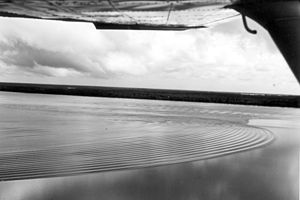
The Severn bore is a tidal bore seen on the tidal reaches of the River Severn in south western England. It is formed when the rising tide moves into the funnel-shaped Bristol Channel and Severn Estuary and the surging water forces its way upstream in a series of waves, as far as Gloucester and beyond. The bore behaves differently in different stretches of the river; in the lower, wider parts it is more noticeable in the deep channels as a slight roller, while the water creeps across the sand and mudflats. In the narrower, upper reaches, the river occupies the whole area between its banks and the bore advances in a series of waves that move upstream. Near Gloucester, the advancing water overcomes two weirs, and sometimes one in Tewkesbury, before finally petering out.

<span class="mw-page-title-main">Estuary</span> Partially enclosed coastal body of brackish water

An estuary is a partially enclosed coastal body of brackish water with one or more rivers or streams flowing into it, and with a free connection to the open sea. Estuaries form a transition zone between river environments and maritime environments and are an example of an ecotone. Estuaries are subject both to marine influences such as tides, waves, and the influx of saline water, and to fluvial influences such as flows of freshwater and sediment. The mixing of seawater and freshwater provides high levels of nutrients both in the water column and in sediment, making estuaries among the most productive natural habitats in the world.

<span class="mw-page-title-main">Hydraulic jump</span> Discharge of high velocity liquid into lower velocity area

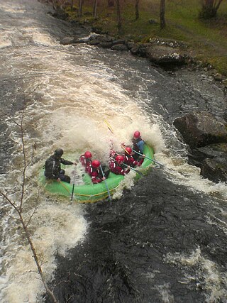
A hydraulic jump is a phenomenon in the science of hydraulics which is frequently observed in open channel flow such as rivers and spillways. When liquid at high velocity discharges into a zone of lower velocity, a rather abrupt rise occurs in the liquid surface. The rapidly flowing liquid is abruptly slowed and increases in height, converting some of the flow's initial kinetic energy into an increase in potential energy, with some energy irreversibly lost through turbulence to heat. In an open channel flow, this manifests as the fast flow rapidly slowing and piling up on top of itself similar to how a shockwave forms.

<span class="mw-page-title-main">Coos Bay</span> Estuary in Oregon, United States

Coos Bay is an estuary where the Coos River enters the Pacific Ocean, the estuary is approximately 12 miles long and up to two miles wide. It is the largest estuary completely within Oregon state lines. The Coos Bay watershed covers an area of about 600 square miles and is located in northern Coos County, Oregon, in the United States. The Coos River, which begins in the Oregon Coast Range, enters the bay from the east. From Coos River, the bay forms a sharp loop northward before arching back to the south and out to the Pacific Ocean. Haynes Inlet enters the top of this loop. South Slough branches off from the bay directly before its entrance into the Pacific Ocean. The bay was formed when sea levels rose over 20,000 years ago at the end of the Last Glacial Maximum, flooding the mouth of the Coos River. Coos Bay is Oregon's most important coastal industrial center and international shipping port, with close ties to San Francisco, the Columbia River, Puget Sound and other major ports of the Pacific rim.

<span class="mw-page-title-main">Hangzhou Bay</span> Inlet of the East China Sea

Hangzhou Bay is a funnel-shaped inlet of the East China Sea, bordered by the province of Zhejiang and the municipality of Shanghai, which lies north of the Bay. The Bay extends from the East China Sea to its head at the city of Hangzhou, from which its name is derived.

<span class="mw-page-title-main">Yaquina Bay</span> Small bay partially within Newport, Oregon, United States

Yaquina Bay is a coastal estuarine community found in Newport, Oregon. Yaquina Bay is a semi-enclosed body of water, approximately 8 km2 (3.2 mi2) in area, with free connection to the Pacific Ocean, but also diluted with freshwater from the Yaquina River land drainage. The Bay is traversed by the Yaquina Bay Bridge.

<span class="mw-page-title-main">Couesnon</span> River in France

The Couesnon is a river running from the département of Mayenne in north-western France, forming an estuary at Mont Saint-Michel. It is 97.8 km (60.8 mi) long, and its drainage basin is 1,124 km2 (434 sq mi). Its final stretch forms the border between the historical duchies of Normandy and Brittany. Its historically irregular course, alternating between two beds on the north and south of the Mont Saint-Michel but eventually definitely settling to the south bed, inspired the saying "The Couesnon in its madness placed the Mont in Normandy", as the Mont is just to the Norman side of the river's current mouth. However, the administrative boundary separating the two regions does not depend on the course of the river, and is about six kilometers west of the Mont.

<span class="mw-page-title-main">Great Bay (New Hampshire)</span>

Great Bay is a tidal estuary located in Strafford and Rockingham counties in eastern New Hampshire, United States. The bay occupies over 6,000 acres (24 km2), not including its several tidal river tributaries. Its outlet is at Hilton Point in Dover, New Hampshire, where waters from the bay flow into the Piscataqua River, thence proceeding southeast to the Atlantic Ocean near Portsmouth. The northern end of the bay, near its outlet, is referred to as Little Bay.

<span class="mw-page-title-main">River surfing</span> Surface water sport

River surfing is the sport of surfing either standing waves, tidal bores or upstream waves in rivers. Claims for its origins include a 1955 ride of 2.4 km (1.5 mi) along the tidal bore of the River Severn.

<span class="mw-page-title-main">Undular bore</span> Wave disturbance in the Earths atmosphere which can be seen through unique cloud formations

In meteorology, an undular bore is a wave disturbance in the Earth's atmosphere and can be seen through unique cloud formations. They normally occur within an area of the atmosphere which is stable in the low levels after an outflow boundary or a cold front moves through.

<span class="mw-page-title-main">Hubert Chanson</span> Australian engineering academic (born 1961)

Hubert Chanson is a professional engineer and academic in hydraulic engineering and environmental fluid mechanics. Since 1990 he has worked at the University of Queensland.

<span class="mw-page-title-main">Trent Aegir</span> Tidal bore on the River Trent in England

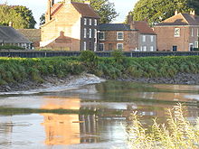
The Trent Aegir, also known as the Eagre, is a tidal bore on the River Trent in England. At certain times of the year, the lower tidal reaches of the Trent experience a moderately large bore. It is said to take its name from Ægir, a personification of the sea in Norse mythology, although this is disputed. A more likely derivation is from Old English ēagor.

Eprapah Creek is a sub-tropical stream in Redland City close to Brisbane in South East Queensland, Australia.

Estuarine water circulation is controlled by the inflow of rivers, the tides, rainfall and evaporation, the wind, and other oceanic events such as an upwelling, an eddy, and storms. Estuarine water circulation patterns are influenced by vertical mixing and stratification, and can affect residence time and exposure time.

<span class="mw-page-title-main">Dordogne (river)</span> River in France

The Dordogne is a river in south-central and southwest France. It is 483.1 km (300.2 mi) long. The Dordogne and its watershed were designated Biosphere Reserve by UNESCO on 11 July 2012.

<span class="mw-page-title-main">Mont-Saint-Michel Bay</span> UNESCO World Heritage Site in Normandy, France

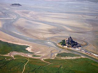
The Mont-Saint-Michel Bay is located between Brittany and the Normandy peninsula of Cotentin. The bay was listed as a UNESCO world heritage site in 1979 for its aesthetic quality and its importance to the Christian tradition. Due to the significant tidal movements in this region a large part of the bay is uncovered at low tide. There are two granitic islands in the bay: Tombelaine and the Mont-Saint-Michel. Many birds and harbor seals live in this area.

<span class="mw-page-title-main">Bec d'Ambès</span>

The Bec d'Ambès is the point of confluence of the rivers Garonne and Dordogne, in the Gironde estuary. Situated 15 miles north of Bordeaux, it has an oil refinery which was destroyed by bombing during World War II, but rebuilt after the war. It is in the Ambès commune.

<span class="mw-page-title-main">Qiantang River</span> East Chinese river

The Qiantang River, formerly known as the Hangchow River or Tsientang River, is a river in East China. An important commercial artery, it runs for 459 kilometers (285 mi) through Zhejiang, passing through the provincial capital Hangzhou before flowing into the East China Sea via Hangzhou Bay south of Shanghai. Its original name, the "Zhe River" or "Zhe Jiang", is the origin of the name of Zhejiang province. The river is also known, along with Hangzhou Bay, for having what is called by locals as the "Silver Dragon", the world's largest tidal bore, a phenomenon where the leading edge of the incoming tide forms a wave that can rise to a height of 9 meters (30 ft) and travels up the river or narrow bay at top speeds of 40 km/h against the direction of the river or bay's current, and can be seen from miles away.

<span class="mw-page-title-main">River plume</span> Mix of fresh river water and seawater

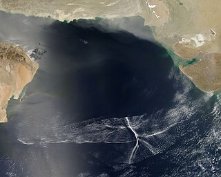
A river plume is a freshened water mass that is formed in the sea as a result of mixing of river discharge and saline seawater. River plumes are formed in coastal sea areas at many regions in the World. River plumes generally occupy wide-but-shallow sea surface layers bounded by sharp density gradients. The area of a river plume is 3-5 orders of magnitude greater than its depth; therefore, even small rivers with discharge rates ~1–10 m/s form river plumes with horizontal spatial extents ~10–100 m. Areas of river plumes formed by the largest rivers are ~100–1000 km2. Despite the relatively small volume of total freshwater runoff to the World Ocean, river plumes occupy up to 21% of shelf areas of the ocean, i.e., several million square kilometers.

References

  1. Sometimes also known as an aegir, eagre, or eygre in the context of specific instances in Britain.
  2. 1 2 3 4 5 Chanson, H. (2011). Tidal Bores, Aegir, Eagre, Mascaret, Pororoca. Theory and Observations. World Scientific, Singapore. ISBN   978-981-4335-41-6.
  3. Figure 5 in: Susan Bartsch-Winkler; David K. Lynch (1988), Catalog of worldwide tidal bore occurrences and characteristics (Circular 1022), U. S. Geological Survey
  4. Chanson, H. (2012). "Momentum considerations in hydraulic jumps and bores". Journal of Irrigation and Drainage Engineering. 138 (4). ASCE: 382–85. doi:10.1061/(ASCE)IR.1943-4774.0000409. ISSN   0372-0187.
  5. Chanson, H. (2009). "Current Knowledge In Hydraulic Jumps And Related Phenomena. A Survey of Experimental Results". European Journal of Mechanics B. 28 (2): 191–210. Bibcode:2009EJMF...28..191C. doi:10.1016/j.euromechflu.2008.06.004. ISSN   0997-7546.
  6. 1 2 3 Chanson, H. (2009). Environmental, Ecological and Cultural Impacts of Tidal Bores, Benaks, Bonos and Burros. Proc. International Workshop on Environmental Hydraulics IWEH09, Theoretical, Experimental and Computational Solutions, Valencia, Spain, 29–30 October Editor P.A. Lopez-Jimenez et al., Invited keynote lecture, 20 pp. (CD-ROM).
  7. Koch, C. and Chanson, H. (2008). "Turbulent Mixing beneath an Undular Bore Front". Journal of Coastal Research. 24 (4): 999–1007. doi:10.2112/06-0688.1. S2CID   130530635.{{cite journal}}: CS1 maint: multiple names: authors list (link)
  8. Koch, C. and Chanson, H. (2009). "Turbulence Measurements in Positive Surges and Bores". Journal of Hydraulic Research. 47 (1): 29–40. Bibcode:2009JHydR..47...29K. doi:10.3826/jhr.2009.2954. S2CID   124743367.{{cite journal}}: CS1 maint: multiple names: authors list (link)
  9. Chanson, H. (2009). "The Rumble Sound Generated by a Tidal Bore Event in the Baie du Mont Saint Michel". Journal of the Acoustical Society of America . 125 (6): 3561–68. Bibcode:2009ASAJ..125.3561C. doi:10.1121/1.3124781. PMID   19507938.
  10. 1 2 Simpson, J.H., Fisher, N.R., and Wiles, P. (2004). "Reynolds Stress and TKE Production in an Estuary with a Tidal Bore". Estuarine, Coastal and Shelf Science . 60 (4): 619–27. Bibcode:2004ECSS...60..619S. doi:10.1016/j.ecss.2004.03.006. during this […] deployment, the [ADCP] instrument was repeatedly buried in sediment after the 1st tidal cycle and had to be dug out of the sediment, with considerable difficulty, at the time of recovery.{{cite journal}}: CS1 maint: multiple names: authors list (link)
  11. Chanson, H., Lubin, P., Simon, B., and Reungoat, D. (2010). Turbulence and Sediment Processes in the Tidal Bore of the Garonne River: First Observations. Hydraulic Model Report No. CH79/10, School of Civil Engineering, The University of Queensland, Brisbane, Australia, 97 pp. ISBN   978-1-74272-010-4.{{cite book}}: CS1 maint: multiple names: authors list (link)
  12. Simon, B., Lubin, P., Reungoat, D., Chanson, H. (2011). Turbulence Measurements in the Garonne River Tidal Bore: First Observations. Proc. 34th IAHR World Congress, Brisbane, Australia, 26 June–1 July, Engineers Australia Publication, Eric Valentine, Colin Apelt, James Ball, Hubert Chanson, Ron Cox, Rob Ettema, George Kuczera, Martin Lambert, Bruce Melville and Jane Sargison Editors, pp. 1141–48. ISBN   978-0-85825-868-6.{{cite book}}: CS1 maint: multiple names: authors list (link)
  13. Chanson, H., Reungoat, D., Simon, B., Lubin, P. (2012). "High-Frequency Turbulence and Suspended Sediment Concentration Measurements in the Garonne River Tidal Bore". Estuarine, Coastal and Shelf Science. 95 (2–3): 298–306. Bibcode:2011ECSS...95..298C. CiteSeerX   10.1.1.692.2537 . doi:10.1016/j.ecss.2011.09.012. ISSN   0272-7714.{{cite journal}}: CS1 maint: multiple names: authors list (link)
  14. Reungoat, D., Chanson, H., Caplain, C. (2014). "Sediment Processes and Flow Reversal in the Undular Tidal Bore of the Garonne River (France)". Environmental Fluid Mechanics . 14 (3): 591–616. Bibcode:2014EFM....14..591R. doi:10.1007/s10652-013-9319-y. ISSN   1567-7419. S2CID   14357850.{{cite journal}}: CS1 maint: multiple names: authors list (link)
  15. Reungoat, D., Chanson, H., Keevil, C. (2014). Turbulence, Sedimentary Processes and Tidal Bore Collision in the Arcins Channel, Garonne River (October 2013). ISBN   9781742721033.{{cite book}}: |journal= ignored (help)CS1 maint: multiple names: authors list (link)
  16. 1 2 Mouazé, D., Chanson, H., and Simon, B. (2010). Field Measurements in the Tidal Bore of the Sélune River in the Bay of Mont Saint Michel (September 2010). Hydraulic Model Report No. CH81/10, School of Civil Engineering, The University of Queensland, Brisbane, Australia, 72 pp. ISBN   978-1-74272-021-0. the field study experienced a number of problems and failures. About 40 s after the passage of the bore, the metallic frame started to move. The ADV support failed completely 10 minutes after the tidal bore.{{cite book}}: CS1 maint: multiple names: authors list (link)
  17. 1 2 Wolanski, E., Williams, D., Spagnol, S., and Chanson, H. (2004). "Undular Tidal Bore Dynamics in the Daly Estuary, Northern Australia". Estuarine, Coastal and Shelf Science. 60 (4): 629–36. Bibcode:2004ECSS...60..629W. doi:10.1016/j.ecss.2004.03.001. About 20 min after the passage of the bore the two aluminium frames at site C were toppled. […] A 3-min-duration patch of macroturbulence was observed. […] This unsteady motion was sufficiently energetic to topple moorings that had survived much higher, quasi-steady currents of 1.8 m/s.{{cite journal}}: CS1 maint: multiple names: authors list (link)
  18. 1 2 Li, Ying; Pan, Dong-Zi; Chanson, Hubert; Pan, Cun-Hong (July 2019). "Real-time characteristics of tidal bore propagation in the Qiantang River Estuary, China, recorded by marine radar" (PDF). Continental Shelf Research. 180. Elsevier: 48–58. Bibcode:2019CSR...180...48L. doi:10.1016/j.csr.2019.04.012. S2CID   155917795. The Qiantang River tidal bore was recorded at two different geographical locations. Characteristic flow patterns were derived and analysed, including temporal changes over a relatively large-scale area. The experimental results showed that the radar-derived celerity and calculated height of the tidal bore were consistent with visual observations in this estuarine zone.
  19. 1 2 3 4 5 6 7 8 9 10 Chanson, H. (2008). Photographic Observations of Tidal Bores (Mascarets) in France. Hydraulic Model Report No. CH71/08, Univ. of Queensland, Australia, 104 pp. ISBN   978-1-86499-930-3.
  20. Ryan Novitra (February 3, 2017). "Riau to Introduce Bono Wave to International Tourism".
  21. p. 159, Barrie R. Bolton. 2009. The Fly River, Papua New Guinea: Environmental Studies in an Impacted Tropical River System. Elsevier Science. ISBN   978-0444529640.
  22. (in French) definition of mascaret
  23. Petitcodiac River changing faster than expected
  24. "Surf's Up -- in Canada! Small New Brunswick Town Becomes International Surfing Hotspot". ABC News . Archived from the original on 2023-04-01.
  25. Natural History of Nova Scotia Vol. I, Chap. T "Ocean Currents", p. 109
  26. (in English) "Pororoca: surfing the Amazon" indicates that "The record that we could find for surfing the longest distance on the Pororoca was set by Picuruta Salazar, a Brazilian surfer who, in 2003, managed to ride the wave for 37 minutes and travel 12.5 kilometers (7.8 mi)."