Cedar Key is a city in Levy County, Florida, United States. The population was 702 at the 2010 census. The Cedar Keys are a cluster of islands near the mainland. Most of the developed area of the city has been on Way Key since the end of the 19th century. The Cedar Keys are named for the eastern red cedar Juniperus virginiana, once abundant in the area.

West Sister Island is an island of the U.S. state of Ohio located in the Western Basin of Lake Erie. The 82 acres (33 ha) island, jointly owned by the United States Coast Guard and the U.S. Fish and Wildlife Service, is Ohio's only designated Wilderness Area, the West Sister Island National Wildlife Refuge.

The Cape Florida Light is a lighthouse on Cape Florida at the south end of Key Biscayne in Miami-Dade County, Florida. Constructed in 1825, it guided mariners off the Florida Reef, which starts near Key Biscayne and extends southward a few miles offshore of the Florida Keys. It was operated by staff, with interruptions, until 1878, when it was replaced by the Fowey Rocks lighthouse. The lighthouse was put back into use in 1978 by the U.S. Coast Guard to mark the Florida Channel, the deepest natural channel into Biscayne Bay. They decommissioned it in 1990.

Alligator Reef Light is located 4 nautical miles east of Indian Key, near the Matecumbe Keys of Florida in the United States, north of Alligator Reef itself. The station was established in 1873. It was automated in 1963 and was last operational in July, 2014, and is being replaced by a 16' steel structure with a less powerful light located adjacent to it. The structure is an iron pile skeleton with a platform. The light is 136 feet (41 m) above the water. It is a white octagonal pyramid skeleton framework on black pile foundation, enclosing a square dwelling and a stair-cylinder. The lantern is black. The original lens was a first order bivalve Fresnel lens. The light characteristic of the original light was: flashing white and red, every third flash red, from SW by W 1/2 W through southward to NE 1/8 E, and from NE by E 3/4 E through northward to SW 3/8 S; flashing red throughout the intervening sectors; interval between flashes 5 seconds. It had a nominal range of 14 nautical miles in the white sectors and 11 nautical miles in the red sectors. The new light has a range of approximately 7 nautical miles.
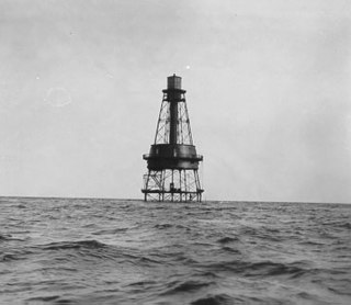
Carysfort Reef Light is located approximately six nautical miles east of Key Largo, Florida. The lighthouse has an iron screw-pile foundation with a platform, and a skeletal, octagonal, pyramidal tower, which is painted red. The light is 100 feet (30 m) above the water. It was the oldest functioning lighthouse of its type in the United States until it was decommissioned in 2015, having been completed in 1852. Carysfort Reef is named for HMS Carysfort (1766), a 20-gun Royal Navy post ship that ran aground on the reef in 1770. The light currently installed is a xenon flashtube beacon. It was added to the National Register of Historic Places in 1984.

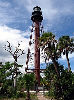
The American Shoal Light is located east of the Saddlebunch Keys, just offshore from Sugarloaf Key, close to Looe Key, in Florida, United States. It was completed in 1880, and first lit on July 15, 1880. The structure was built to the same plan and dimensions as the Fowey Rocks lighthouse, completed in 1878.

The Dry Tortugas Light is a lighthouse located on Loggerhead Key, three miles west of Fort Jefferson, Florida. It was taken out of operation in 2015. It has also been called the Loggerhead Lighthouse. It has been said to be "a greater distance from the mainland than any other light in the world."
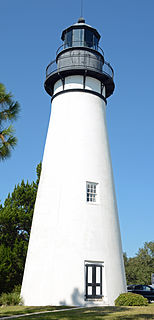
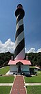
The Amelia Island Light is the oldest existing lighthouse in the state of Florida in the United States. It is located near the northern end of Amelia Island in the northeastern part of the state. Its light marks St. Marys Entrance, the inlet leading to St. Marys River, the Cumberland Sound and the harbor of Fernandina Beach, Florida along the Amelia River. The white light flashes every ten seconds which turns red from 344° to 360° when covering the shoal water in the vicinity of Nassau Sound.
The Anclote Keys Light is a lighthouse built in 1887 on Anclote Key, the largest of the Anclote Keys. It is a skeletal square pyramidal tower, painted brown, with a black lantern. After the lighthouse was automated in 1952 the tower and other buildings at the site were often vandalized, interfering with the operation of the light. The Coast Guard determined that the light was no longer needed and deactivated it in 1984. The site was eventually turned over to the State of Florida and added to Anclote Key Preserve State Park. As of 2003 the lighthouse has been restored and relighted using a reproduction fourth-order Fresnel lens. Anclote Key is accessible only by boat.

Egmont Key State Park and National Wildlife Refuge is a Florida State Park located on the island of Egmont Key, at the mouth of Tampa Bay. Egmont Key lies southwest of Fort De Soto Park and can only be reached by boat or ferry. Located within Egmont Key State Park are the 1858 Egmont Key Lighthouse, maintained by the U.S. Coast Guard, and the ruins of Fort Dade, a Spanish–American War era fort that housed 300 residents. Egmont Key is located in Hillsborough County Florida on a narrow strip of the county that extends along the Tampa Port Shipping Channel.

The Dog Island Light was located on the western tip of Dog Island south of Carrabelle, Florida. It marked the "middle entrance to St. George's Sound," between St. George and Dog Islands, during the nineteenth century, until its collapse by a hurricane in 1873.

The current Egmont Key Light dates from 1858. It is the oldest structure in the Tampa Bay area still used for its original purpose.

The Ponce de Leon Inlet Light is a lighthouse and museum located at Ponce de León Inlet in Central Florida. At 175 feet (53 m) in height, it is the tallest lighthouse in the state and one of the tallest in the United States. It is located between St. Augustine Light and Cape Canaveral Light. Restored by the Ponce de Leon Inlet Lighthouse Preservation Association, the lighthouse became a National Historic Landmark in 1998.

The St. Marks Light is the second-oldest light station in Florida. It is located on the east side of the mouth of the St. Marks River, on Apalachee Bay.

The Plum Island Range Lights are a pair of range lights located on Plum Island in Door County, Wisconsin. They were part of the Plum Island United States Life-Saving Station. Plum Island was transferred to the United States Fish and Wildlife Service in 2007 and became part of the Green Bay National Wildlife Refuge. The life-saving station was listed on the National Register of Historic Places in 2010. Plum Island is closed to the public to protect ground nesting migratory birds.

The Point Montara Light is a lighthouse in Montara, California, United States, on the southern approach to the San Francisco Bay, California approximately 25 miles south of San Francisco.

Atsena Otie Key is a barrier island and ghost town one-half mile offshore of Cedar Key, Florida. Atsena Otie was the original site of the town of Cedar Key, and in the present day includes a walking trail, swimming area, and ruins of the Eberhard Faber mill. The property is part of the Cedar Key National Wildlife Refuge and is managed by the U.S. Fish and Wildlife Service.

The Cove Point Light is a lighthouse located on the west side of Chesapeake Bay in Calvert County, Maryland.
The Lower Cedar Point Light was a historic lighthouse in the Potomac River near its eponymous point, south of the present U.S. Route 301 bridge. It has been replaced by a skeleton tower.

Piedras Blancas Light Station is located at Point Piedras Blancas, about 5.5 miles (8.9 km) west by northwest of San Simeon, California. It was added to the California Coastal National Monument in 2017.