Cedaredge, Colorado

Last updated

Cedaredge, Colorado
Town of Cedaredge [1]
Cedaredge from cedar mesa.jpg
Cedaredge as seen from Cedar Mesa.
Nicknames: 
The Southern Gateway to the Grand Mesa.
Delta County Colorado Incorporated and Unincorporated areas Cedaredge Highlighted 0812635.svg
Location of the Town of Cedaredge in Delta County, Colorado.
Usa edcp location map.svg
Red pog.svg
Cedaredge
Location of the Town of Cedaredge in the United States.
Coordinates: 38°53′39″N107°5′32″W / 38.89417°N 107.09222°W / 38.89417; -107.09222 [2]
Country Flag of the United States.svg  United States
State Flag of Colorado.svg  Colorado
County Delta County [1]
Incorporated May 2, 1907 [3]
Government
  Type Home rule municipality [1]
Area
[4]
  Total1.961 sq mi (5.078 km2)
  Land1.961 sq mi (5.078 km2)
  Water0.000 sq mi (0.000 km2)
Elevation
[2]
6,135 ft (1,870 m)
Population
 (2020) [4]
  Total2,279
  Density1,162/sq mi (449/km2)
Time zone UTC−07:00 (MST)
  Summer (DST) UTC−06:00 (MDT)
ZIP Code
81413 [5]
Area code 970
FIPS code 08-12635
GNIS feature ID 2413184 [2]
Website Town of Cedaredge

Cedaredge is a home rule municipality located in Delta County, Colorado, United States. [1] It is a small, agricultural community with 2,279 residents as of 2020, [4] producing beef cattle, elk, apples, and peaches. Cedaredge is also home to several of the 19 wineries in Delta County, [6] produced from the region's few basic vineyards. Located beneath the southern slopes of the Grand Mesa in the Surface Creek Valley, Cedaredge has an elevated vantage point that affords southern views of the San Juan Mountains, the Black Canyon of the Gunnison National Park, and the Coloradan communities of Delta, Olathe, and Montrose.

Contents

History

Early history

Up until 1880 much of central and western Colorado was inhabited by the Ute Indians. Under the Act of June 15, 1880, the Utes ceded a large portion of their land to the United States, including the Surface Creek Valley. On September 1, 1881, the last band of Utes made their exodus from western Colorado to the northeastern part of Utah under escort of troops from Fort Crawford.[ citation needed ] Settlers soon began arriving, building homesteads, barns, businesses, and ranches. Much of the land was carved up into cattle ranches, fruit orchards, and fields of alfalfa, and grass, but the most successful business is cattle ranching to the west of the town.[ citation needed ]

The town of Cedaredge was officially incorporated on March 25, 1907, by a few ranchers.[ citation needed ]

Cedaredge is on the Loewen database of possible sundown towns. [7]

McGruder fire on 7-3-04 below Rollins Sandstone McGruderFire7-03-04.JPG
McGruder fire on 7-3-04 below Rollins Sandstone

On July 2, 2004, a lightning strike caught a tree on fire, smoldering until the following day when hot dry winds fanned the flames into a large wildfire. Dubbed the McGruder fire, it consumed an area of approximately 3,000 acres (12 km2), of which 1,467 acres (5.94 km2) was privately owned, the rest belonging to the Bureau of Land Management (BLM) and the United States Forest Service.[ citation needed ] The Cedaredge volunteer fire department (VFD) and regional firefighting services worked to suppress the fire, containing it with fire lines by July 11 with no homes or lives being lost.

Cedaredge celebrated its centennial in 2007.

Geography

At the 2020 United States Census, the town had a total area of 1,255 acres (5.078 km2), all of it land. [4]

Climate

The climate in Cedaredge, like much of the Grand Valley and Uncompahgre Valley, consists of mild, snowy winters; summers are hot and dry with scattered afternoon thunderstorms occurring often but delivering a small amount of total precipitation. Summers see typical highs of 92 and lows of 60, winters can see highs in the 50s and lows of 11 °F (−12 °C).

Demographics

Historical population
CensusPop.Note
1910 295
1920 45554.2%
1930 4631.8%
1940 55620.1%
1950 5743.2%
1960 549−4.4%
1970 5815.8%
1980 1,184103.8%
1990 1,38016.6%
2000 1,85434.3%
2010 2,25321.5%
2020 2,2791.2%
U.S. Decennial Census

As of the census [8] of 2010, there were 2,253 people, 894 households, and 554 families residing in the town. The population density was 898.9 inhabitants per square mile (347.1/km2). There were 1,000 housing units at an average density of 484.9 units per square mile (187.2 units/km2). The racial makeup of the town was 96.01% White, 0.50% African American, 0.38% Native American, 0.43% Asian, 0.16% Pacific Islander, 0.59% from other races, and 2.37% from two or more races. Hispanic or Latino of any race were 5.39% of the population.

There were 894 households, out of which 20.8% had children under the age of 18 living with them, 51.6% were married couples living together, 7.3% had a female householder with no husband present, and 38.0% were non-families. 34.3% of all households were made up of individuals, and 21.1% had someone living alone who was 65 years of age or older. The average household size was 2.07 and the average family size was 2.61.

In the town, the population was spread out, with 18.8% under the age of 18, 5.5% from 18 to 24, 19.0% from 25 to 44, 25.1% from 45 to 64, and 31.6% who were 65 years of age or older. The median age was 51 years. For every 100 females, there were 88.2 males. For every 100 females age 18 and over, there were 85.3 males.

The median income for a household in the town was $27,381, and the median income for a family was $35,052. Males had a median income of $32,426 versus $21,500 for females. The per capita income for the town was $20,059. About 10.0% of families and 14.9% of the population were below the poverty line, including 20.8% of those under age 18 and 10.4% of those age 65 or over. The median gross rent was $796 a month (2011), estimated rent burden was 34.6%. [9]

Sites of interest and events

AppleFest

In 1978 the "Cedaredge Harvest Festival" officially changed its name to "AppleFest." AppleFest is an annual celebration of apples, arts, music, and food held the first weekend in October in Cedaredge, Colorado. It is attended by around 15,000 visitors each year and typically over 200 food, arts and crafts vendors. The event features a classic car show, antique tractor show, and motorcycle show.

Musical guests feature folk, gospel, blues, country, rock, bluegrass and others with local, regional and national artists.

Since 2000, the festival has also included a chili cooking competition fundraiser organized by the Cedaredge VFD.

AppleFest 2014 marked the 37th Anniversary of the event.[ citation needed ]

Pioneer Town

Pioneer Town entrance in Cedaredge, Colorado. Pictured are Stolte fruit packing shed and historic Bar-I grain silos. Cedaredgepioneertown.jpg
Pioneer Town entrance in Cedaredge, Colorado. Pictured are Stolte fruit packing shed and historic Bar-I grain silos.

Pioneer Town is a museum and historical village open from Memorial Day weekend through the first weekend in October. The centerpieces of Pioneer Town are the octagonal Bar-I Silos, the last remaining structures of the Bar-I Ranch, a cattle ranch that was established in the early 1880s. The museum's replicas of early 20th-century town buildings include a western saloon, marshall's office, barber shop, bank, clothing store, jail, creamery, and a working blacksmith's shop. It also includes Chapel of the Cross, a prairie-style chapel housing one of the world's largest digital organs, the Doll and Toy House, a museum of historical dolls and toys, and the Sutherland Indian Museum, housing one of Colorado's largest arrowhead displays. The old Stolte Packing Shed also serves as a rental facility for local events and receptions the Antique and Classic Car Show during the town's AppleFest weekend celebration.

Cedaredge Golf Club

Opened in the Spring of 1988, as the Deer Creek Village Golf Club, Cedaredge Golf Club is a public golf course in Cedaredge, Colorado. The golf course was completed in April 1992 and is located on what was part of the Bar-I Cattle Ranch hayfields of the early 1900s. This 18-hole course has four tee boxes per hole. Cedaredge Golf Club includes a driving range, clubhouse, and grill.[ citation needed ]

Located in a protected valley at 6,100 feet (1,900 m) in elevation, the Cedaredge Golf Club course has natural cedars and winding creek beds.[ citation needed ]

Grand Mesa Scenic and Historic Byway

The Grand Mesa Scenic and Historic Byway scenic and historic byway was approved by the Colorado Department of Transportation in 1991. It runs North from Cedaredge along Highway 65, to the top of the Grand Mesa at more than 10,000 feet (3,000 m). Grand Mesa visitors center has maps, books and other information about the area. The byway sneaks past Island Lake, one of more than 300 trout-filled lakes in Grand Mesa National Forest. On the north side of the Mesa are the towns of Mesa, Collbran, and Powderhorn Ski Resort. The byway continues along De Beque Canyon, with its colorful sandstone bluffs, and eventually meets Interstate 70 in the town of De Beque.

Education

Education in the early days of Surface Creek Valley consisted of several one-room school houses scattered across the rural countryside. In 1920 the new Consolidated Cedaredge High School was constructed and regular bussing began in the area.

Cedaredge High School

Completed in 1982, the current Cedaredge High School has an enrollment of approximately 250 students. Unusual for a school of its size,[ citation needed ] it contains a technology lab, geodesic greenhouse, and an integrated cafeteria/auditorium. The mascot for its athletic teams is the Bruin and it competes in 1A football, and basketball, and in division 3A for volleyball, wrestling, baseball, swimming, tennis, and track. The Cedaredge High School Bruin Marching Band has won seven state marching titles in class 1A (2002, 2003, 2005, 2011, 2012, 2013, and 2014) The band set the record in 2011 for the smallest band (23 members) to win a state championship in Colorado and broke that record in 2012 with 17 members.

The (boys') football team won second place in the state championships in 1993, with the final being held at Cedaredge High School. After the team had not been to the state play-offs since 2002 and the 2008 season resulted in a win of 4 out of 10 games (no draws), the team was considered to have been "down the past several years" even by local media; [10] the Denver Post criticized as its primary weakness the "lack of playing as a team." [11] The school managed to hire Rich Stubler, who coached for 22 years in the Canadian Football League including being head coach for the Toronto Argonauts for 10 games in 2008, as new head coach starting in the off-season of 2009; Stubler explained his choice of working for a small town high school with needing a break. [12] The team finished the season with Stubler with 2 wins out of 10 games (no draws). [13] They hired Brandon Milholland the next year (2010) and he would lead the team to a state championship in 2012.

Roger Ellison, a 17-year-old senior, disappeared from the basement of the former Cedaredge High School on February 10, 1981. He has been neither seen nor heard from since, and authorities believe he was killed by someone he knew shortly after he vanished. [14] [15]

Cedaredge Middle School

Cedaredge Middle School occupied the original building of the Cedaredge Consolidated High School from the early 1980s until the current home for Cedaredge Middle School was built in 2004. It is located between the High School and Deer Creek Village golf course at the foot of Cedar Mesa.

Cedaredge Elementary School

The original school was built in 1959 and also known as Cedaredge Hunsicker Elementary School. A new school was completed on the south side of the road in 2012, and the parts of the old school on the north side of the road now serve the Surface Creek Vision Program.

Surface Creek Vision Program

Founded in 2003, the Surface Creek branch of the Delta County Vision program is a synthesis of homeschooling and public schooling philosophies.[ citation needed ]

Cedaredge Public Library

The current home for the Cedaredge Public Library was built in the 1990s.[ citation needed ]

See also

Related Research Articles

<span class="mw-page-title-main">Rio Grande County, Colorado</span> County in Colorado, United States

Rio Grande County is a county located in the U.S. state of Colorado. As of the 2020 census, the population was 11,539. The county seat is Del Norte. The county is named for the Rio Grande, which flows through the county.

<span class="mw-page-title-main">Moffat County, Colorado</span> County in Colorado, United States

Moffat County is a county located in the U.S. state of Colorado. As of the 2020 census, the population was 13,292. The county seat is Craig. With an area of 4,751 square miles, it is the second-largest county by area in Colorado, behind Las Animas County.

<span class="mw-page-title-main">Mesa County, Colorado</span> County in Colorado, United States

Mesa County is a county located in the U.S. state of Colorado. As of the 2020 census, the population was 155,703. The county seat and most populous municipality is Grand Junction. The county was named for the many large mesas in the area, including the Grand Mesa, which is the largest flat-topped mountain in the world.

<span class="mw-page-title-main">Gunnison County, Colorado</span> County in Colorado, United States

Gunnison County is a county located in the U.S. state of Colorado. As of the 2020 census, the population was 16,918. The county seat is Gunnison. The county was named for John W. Gunnison, a United States Army officer and captain in the Army Topographical Engineers, who surveyed for the transcontinental railroad in 1853.

<span class="mw-page-title-main">Garfield County, Colorado</span> County in Colorado, United States

Garfield County is a county located in the U.S. state of Colorado. As of the 2020 census, the population was 61,685. The county seat is Glenwood Springs. The county is named in honor of United States President James A. Garfield. Garfield County is included in the Glenwood Springs, CO Micropolitan Statistical Area, which is also included in the Edwards-Glenwood Springs, CO Combined Statistical Area.

<span class="mw-page-title-main">Delta County, Colorado</span> County in Colorado, United States

Delta County is a county located in the U.S. state of Colorado. As of the 2020 census, the population was 31,196. The county seat is Delta.

<span class="mw-page-title-main">Clear Creek County, Colorado</span> County in Colorado, United States

Clear Creek County is a county located in the U.S. state of Colorado. As of the 2020 census, the population was 9,397. The county seat is Georgetown.

<span class="mw-page-title-main">Crawford, Colorado</span> Town in Colorado, United States

The Town of Crawford is a Statutory Town in Delta County, Colorado, United States. The town population was 403 at the 2020 United States Census. The surrounding mesas and valleys support a farming and ranching community.

<span class="mw-page-title-main">Delta, Colorado</span> City in Colorado, United States

Delta is a home rule municipality that is the county seat and the most populous municipality of Delta County, Colorado, United States. The town population was 9,035 at the 2020 United States Census. The United States Forest Service headquarters of the Grand Mesa, Gunnison, and Uncompahgre National Forests are located in Delta.

<span class="mw-page-title-main">Paonia, Colorado</span> Town in Colorado, United States

Paonia is a statutory town in Delta County, Colorado, United States. The population was 1,447 at the 2020 census.

<span class="mw-page-title-main">Rifle, Colorado</span> City in Colorado, United States

Rifle is a home rule municipality in, and the most populous community of, Garfield County, Colorado, United States. The population was 10,437 at the 2020 census. Rifle is a regional center of the cattle ranching industry located along Interstate 70 and the Colorado River just east of the Roan Plateau, which dominates the western skyline of the town. The town was founded in 1882 by Abram Maxfield, and was incorporated in 1905 along Rifle Creek, near its mouth on the Colorado. The community takes its name from the creek.

<span class="mw-page-title-main">Crested Butte, Colorado</span> Town in Colorado, United States

Crested Butte is a home rule municipality located in Gunnison County, Colorado, United States. The town population was 1,639 at the 2020 United States Census. A former coal mining town nestled in the Slate River Valley, Crested Butte is now known as a destination for skiing, mountain biking, and outdoor activities.

<span class="mw-page-title-main">Collbran, Colorado</span> Town in Mesa County, Colorado, United States

Collbran is a statutory town located in Mesa County, Colorado, United States. The town's population was 369 at the 2020 Census. Collbran is a part of the Grand Junction, CO Metropolitan Statistical Area.

<span class="mw-page-title-main">De Beque, Colorado</span> Town in Colorado, United States

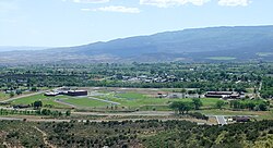
De Beque is a statutory town located in Mesa County, Colorado. The population was 493 at the time of the 2020 census. De Beque is a part of the Grand Junction, CO Metropolitan Statistical Area. The town consists of a small grid, including a historic downtown featuring a town hall, a tavern, and several commercial businesses in historic structures. The surrounding streets include houses, several churches, and a school.

<span class="mw-page-title-main">Cortez, Colorado</span> City in Colorado, United States

Cortez is a home rule municipality that is the county seat and the most populous municipality of Montezuma County, Colorado, United States. The city population was 8,766 at the 2020 United States Census.

<span class="mw-page-title-main">Mancos, Colorado</span> Town in Colorado, United States

Mancos is a statutory town in Montezuma County, Colorado, United States. The population was 1,196 at the 2020 census, down from 1,336 in 2010.

<span class="mw-page-title-main">Del Norte, Colorado</span> Statutory Town in Colorado, United States

Del Norte is a Statutory Town that is the county seat of Rio Grande County, Colorado, United States. The town's name is most commonly pronounced /ˈdɛl nɔɹt/. The town population was 1,458 at the 2020 United States Census.

<span class="mw-page-title-main">Plateau Creek (Colorado)</span> Creek in Mesa County, Colorado, United States

Plateau Creek is a tributary of the Colorado River, approximately 50 miles (80 km) long, in Mesa County, Colorado, United States. It drains a cattle ranching valley, known as Plateau Valley, north of the Grand Mesa and east of Grand Junction.

<span class="mw-page-title-main">Grand Mesa</span> Mountain in Colorado, US

The Grand Mesa is a large mesa in western Colorado in the United States. It is the largest flat-topped mountain in the world. It has an area of about 500 square miles (1,300 km2) and stretches for about 40 miles (60 km) east of Grand Junction between the Colorado River and the Gunnison River, its tributary to the south. The north side of the mesa is drained largely by Plateau Creek, a smaller tributary of the Colorado. The west side is drained largely by Kannah Creek, which is received to the west by the lower Gunnison River. The mesa rises about 6,000 feet (1,800 m) above the surrounding river valleys, including the Grand Valley to the west, reaching an elevation of about 11,000 feet (3,400 m). Much of the mesa is within Grand Mesa National Forest. Over 300 lakes, including many reservoirs created and used for drinking and irrigation water, are scattered along the top of the formation. The Grand Mesa is flat in some areas, but quite rugged in others.

<span class="mw-page-title-main">Colorado State Highway 65</span> State highway in Colorado, United States

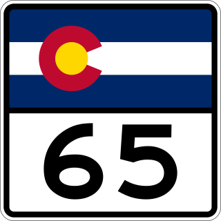
State Highway 65 (SH 65) is a state highway in Colorado that crosses the Grand Mesa. The highway along with a road to Lands End Overlook were designated as the Grand Mesa National Scenic Byway in 1996. SH 65's southern terminus is at SH 92 east of Delta, and its northern terminus is at Interstate 70 (I-70) and U.S. Route 6 (US 6) northeast of Palisade.

References

  1. 1 2 3 4 5 "Active Colorado Municipalities". Colorado Department of Local Affairs . Retrieved October 15, 2021.
  2. 1 2 3 U.S. Geological Survey Geographic Names Information System: Cedaredge, Colorado
  3. "Colorado Municipal Incorporations". State of Colorado, Department of Personnel & Administration, Colorado State Archives. December 1, 2004. Retrieved September 2, 2007.
  4. 1 2 3 4 "Decennial Census P.L. 94-171 Redistricting Data". United States Census Bureau, United States Department of Commerce. August 12, 2021. Retrieved September 2, 2021.
  5. "ZIP Code Lookup". United States Postal Service. Archived from the original (JavaScript/HTML) on September 3, 2007. Retrieved September 4, 2007.
  6. High Peak Strategy (June 2021). "Colorado Wine Industry Economic Impact Study" (PDF). coloradowine.com. Colorado Wine Industry Development Board. Archived from the original (PDF) on September 30, 2023.
  7. "Using the Sundown Towns Database". History and Social Justice. Retrieved September 22, 2023.
  8. "U.S. Census website". United States Census Bureau . Retrieved January 31, 2008.
  9. "Cedaredge, CO". Address-Data.com.[ permanent dead link ]
  10. Wayne Crick (2 September 2009). Cedaredge football has new coach. Delta County Independent (retrieved February 25, 2010)
  11. Brian Forbes & Michael Hicks (1 September 2009). Prep football Class 2A team previews. The Denver Post (retrieved February 25, 2010)
  12. Sam Farnsworth (20 August 2009). Football Campin': Cedaredge High School. NBC11News (retrieved February 25, 2010)
  13. (no author, no date). Cedaredge Bruins High School Football Home. MaxPreps (retrieved February 25, 2010)
  14. "Roger John Ellison – the Charley Project".
  15. "Have you seen this child? Roger Ellison". missingkids.com.