Central, South Carolina

Last updated

Central, South Carolina
CentralSCMon.png
SCMap-doton-Central.PNG
Location of Central within South Carolina
Coordinates: 34°43′26″N82°46′47″W / 34.72389°N 82.77972°W / 34.72389; -82.77972
Country United States
State South Carolina
County Pickens
Incorporated 1875 [1]
Government
  MayorAndrew J. Beckner [2]
Area
[3]
  Total3.07 sq mi (7.94 km2)
  Land3.06 sq mi (7.93 km2)
  Water0.00 sq mi (0.01 km2)
Elevation
[4]
906 ft (276 m)
Population
 (2020) [5]
  Total5,296
  Density1,713.59/sq mi (661.56/km2)
Time zone UTC−5 (Eastern (EST))
  Summer (DST) UTC−4 (EDT)
ZIP Code
29630
Area code 864
FIPS code 45-13015 [6]
GNIS feature ID1247236 [4]
Website cityofcentral.org

Central is a town in Pickens County, South Carolina, United States. As of the 2010 census, the population was 5,159, roughly 3,000 of whom were considered permanent residents. [7] Contrary to its name, it is not near South Carolina's center. It received its name from being halfway or the central point between Atlanta and Charlotte along the former Atlanta and Richmond Air-Line Railway line. Southern Wesleyan University's main campus is east of downtown Central.

Contents

History

Central was founded by the Atlanta and Richmond Air Line Railway in a railroad boom that began in 1873. [8] The town's name represents the fact that it is midway between Atlanta and Charlotte. [1] Central was incorporated as a town on March 17, 1875. [1]

In 1897, Southern Railway moved its headquarters from Central to Greenville; trains no longer stopped to change engines, and soon all shops and offices were closed. [1] The establishment of Issaqueena Mill and, in 1906, [9] Wesleyan Methodist Bible Institute (now Southern Wesleyan University) brought people back to the town. [1]

Two buildings on Church Street in Central are listed on the National Register of Historic Places: Central High School and Morgan House. The Central Roller Mills on Madden Bridge Road was listed in 2013.

Geography

Central is located at 34°43′26″N82°46′47″W / 34.723781°N 82.779754°W / 34.723781; -82.779754 . [10] According to the United States Census Bureau, the town has an area of 2.4 square miles (6.2 km2), all of it land.

Downtown Central is bisected by a rail line. A significant number of late 19th- to early 20th-century commercial buildings remain, most of which are single-story and retain a good amount of historical integrity. As of 2006,[ citation needed ] a downtown streetscape project is underway that is designed to improve the area's aesthetics. There are also many modest pre-World War II homes near the downtown. Central has several large apartment complexes, including The Reserve, which primarily house students from nearby Clemson University (who can use Clemson Area Transit to get there), as well as from Southern Wesleyan University.

The Central Heritage Society has a museum and information on many historic buildings and homes in the area.

Attractions

In addition to Southern Wesleyan University, the town is home to Grand Central Station, a disc golf course that hosts Professional Disc Golf Association (PDGA) tournaments.

Demographics

Historical population
CensusPop.Note
1880 184
1890 396115.2%
1900 349−11.9%
1910 886153.9%
1920 8981.4%
1930 1,44060.4%
1940 1,4963.9%
1950 1,263−15.6%
1960 1,47316.6%
1970 1,5505.2%
1980 1,91423.5%
1990 2,43827.4%
2000 3,52244.5%
2010 5,15946.5%
2020 5,2471.7%
U.S. Decennial Census [11] [5]

Central is part of the Greenville Mauldin Easley metropolitan area.

2000 census

As of the census [6] of 2000, there were 3,522 people, 1,560 households, and 617 families residing in the town. The population density was 1,463.4 inhabitants per square mile (565.0/km2). There were 1,832 housing units at an average density of 761.2 per square mile (293.9/km2). The racial makeup of the town was 79.70% White, 15.25% African American, 1.79% Asian, 0.03% Native American, 2.13% from other races, and 1.11% from two or more races. Hispanic or Latino of any race were 4.32% of the population.

There were 1,560 households, of which 17.2% had children under the age of 18 living with them, 27.1% were married couples living together, 8.9% had a female householder with no husband present, and 60.4% were non-families. 35.1% of all households were made up of individuals, and 7.2% had someone living alone who was 65 years of age or older. The average household size was 2.19 and the average family size was 2.91.

In the town, the population was spread out, with 15.1% under the age of 18, 37.4% from 18 to 24, 25.7% from 25 to 44, 12.7% from 45 to 64, and 9.2% who were 65 years of age or older. The median age was 24. For every 100 females, there were 116.3 males. For every 100 females age 18 and over, there were 115.5 males.

The median income for a household in the town was $23,869, and the median income for a family was $39,524. Males had a median income of $26,855 versus $22,207 for females. The per capita income for the town was $14,394. About 11.3% of families and 29.2% of the population were below the poverty line, including 19.0% of those under age 18 and 8.2% of those age 65 or over.

2010 census

Central's population has grown rapidly since 2000, mostly due to the construction of apartment complexes for students attending Clemson University, Southern Wesleyan and Tri-County Technical College.

2020 census

Central racial composition [12]
RaceNum.Perc.
White (non-Hispanic)3,37564.32%
Black or African American (non-Hispanic)91117.36%
Native American 180.34%
Asian 3055.81%
Other/Mixed 2514.78%
Hispanic or Latino 3877.38%

As of the 2020 United States census, there were 5,247 people, 2,483 households, and 796 families residing in the town.

Education

Public education is provided by the School District of Pickens County (Pickens 01), including D. W. Daniel High School, a 2005 National Blue Ribbon School.

The Central Clemson Regional Branch library, part of the Pickens County Library System, serves as the community's public library.

Central shares educational facilities and transportation services with the adjacent city of Clemson.

Southern Wesleyan University

Central is home to Southern Wesleyan University's main campus. Southern Wesleyan University is a SACS-accredited four-year Christian university [13] founded in 1906. The main campus houses over 600 traditional undergraduate students. It has three main housing buildings, two fine arts centers, a dining hall, a library, a gym, and many class buildings. The campus is also home to FWC Alive, a Wesleyan church that offers a traditional worship service and a contemporary worship service.

Library

Central has a public library, a branch of the Pickens County Library System. [14]

Town government

The town has a council form of government, with six elected council members and a mayor serving as the presiding officer. Members of council are elected to four-year terms. Day-to-day operations are governed by a town administrator.

Notable people

Related Research Articles

<span class="mw-page-title-main">Pickens County, South Carolina</span> County in South Carolina, United States

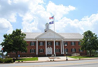
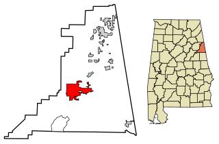
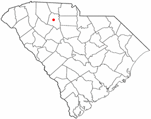
Pickens County is located in the northwest part of the U.S. state of South Carolina. As of the 2020 census, its population was 131,404. Its county seat is Pickens. The county was created in 1826. It is part of the Greenville-Anderson-Greer, SC Metropolitan Statistical Area.

<span class="mw-page-title-main">Oconee County, South Carolina</span> County in South Carolina, United States

Oconee County is the westernmost county in the U.S. state of South Carolina. As of the 2020 census, the population was 78,607. Its county seat is Walhalla and its largest community is Seneca. Oconee County is included in the Seneca, SC Micropolitan Statistical Area, which is also included in the Greenville-Spartanburg-Anderson, SC Combined Statistical Area. South Carolina Highway 11, the Cherokee Foothills National Scenic Highway, begins in southern Oconee County at Interstate Highway 85 at the Georgia state line.

<span class="mw-page-title-main">Anderson County, South Carolina</span> County in South Carolina, United States

Anderson County is a county located in the U.S. state of South Carolina. As of the 2020 census, its population was 203,718. Its county seat is Anderson. Named for Revolutionary War leader Robert Anderson, the county is located in northwestern South Carolina, along the state line of Georgia. Anderson County is included in the Greenville-Anderson-Greer, SC Metropolitan Statistical Area. Anderson County contains 55,950-acre (22,640 ha) Lake Hartwell, a U.S. Army Corps of Engineers lake with nearly 1,000 miles (1,600 km) of shoreline for residential and recreational use. The area is a growing industrial, commercial and tourist center. It is the home of Anderson University, a private, selective comprehensive university of approximately 4,000 undergraduate and graduate students.

<span class="mw-page-title-main">Heflin, Alabama</span> City in Alabama, United States

Heflin is a city and the county seat of Cleburne County, Alabama, United States. At the 2020 census, the population was 3,431. It is located approximately halfway between Birmingham and Atlanta along Interstate 20.

<span class="mw-page-title-main">Wadley, Alabama</span> Town in Alabama, United States

Wadley is a town in Randolph County, Alabama, United States. It is home to the Wadley campus of Southern Union State Community College. As of the 2010 census, the population of the town was 751, up from 640 in 2000. According to the 1910 U.S. Census, the town was incorporated in 1908.

<span class="mw-page-title-main">Greenville, Florida</span> Town in the state of Florida, United States

Greenville is a town in Madison County, Florida, United States. The population was 746 at the 2020 census, down from 843 at the 2010 census.

<span class="mw-page-title-main">Lilburn, Georgia</span> City in Georgia, United States

Lilburn is a city in Gwinnett County, Georgia, United States. The population was 14,502 at the 2020 census. The estimated population was 12,810 in 2019. It is a part of the Atlanta metropolitan area.

<span class="mw-page-title-main">Norcross, Georgia</span> City in Georgia, United States

Norcross is a city located in Gwinnett County, Georgia, United States. According to the 2010 census, the population was 9,116, while in 2020, the population increased to 17,209. Norcross is part of the Atlanta-Sandy Springs-Marietta metropolitan statistical area.

<span class="mw-page-title-main">Jasper, Georgia</span> City and county seat in Georgia, United States

Jasper is a city in Pickens County, Georgia, United States. The population was 3,684 at the 2010 census. The city is the county seat of Pickens County.

<span class="mw-page-title-main">Westfield, Indiana</span> City in Indiana, United States

Westfield is a city in Hamilton County, Indiana, United States. As of the 2010 census the population was 30,068, and in 2023 the population was 58,410. Westfield is in the Indianapolis metropolitan area.

<span class="mw-page-title-main">Pendleton, South Carolina</span> Town in South Carolina, United States

Pendleton is a town in Anderson County, South Carolina, United States. The population was 3,489 at the 2020 census. It is a sister city of Stornoway in the Outer Hebrides of Scotland.

<span class="mw-page-title-main">Gantt, South Carolina</span> Census-designated place in South Carolina, United States

Gantt is a census-designated place (CDP) in Greenville County, South Carolina, United States. The population was 14,229 at the 2010 census. It is part of the Greenville–Mauldin–Easley Metropolitan Statistical Area and a suburb of the city of Greenville.

<span class="mw-page-title-main">Seneca, South Carolina</span> City in Oconee County, South Carolina

Seneca is a city in Oconee County, South Carolina, United States. The population was 8,102 at the 2010 census. It is the principal city of the Seneca Micropolitan Statistical Area, an (MSA) that includes all of Oconee County, and that is included within the greater Greenville-Spartanburg-Anderson, South Carolina Combined Statistical Area. Seneca was named for the nearby Cherokee town of Isunigu, which English colonists knew as "Seneca Town".

<span class="mw-page-title-main">Easley, South Carolina</span> City in South Carolina, United States

Easley is a city in Pickens County in the U.S. state of South Carolina. Most of the city lies in Pickens County, with a small portion of the city in Anderson County.

<span class="mw-page-title-main">Liberty, South Carolina</span> City in South Carolina, United States

Liberty is a city in Pickens County, South Carolina, United States. It is part of the Greenville–Mauldin–Easley Metropolitan Statistical Area. The city was chartered on March 2, 1876.

<span class="mw-page-title-main">Pickens, South Carolina</span> City in South Carolina, United States

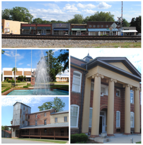
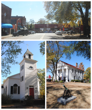
Pickens, formerly called Pickens Courthouse, is a city in and the county seat of Pickens County, South Carolina, United States. The population was 3,126 at the 2010 census. Pickens changed its classification from a town to a city in 1998, but it was not reported to the Census Bureau until 2001. It was named after Andrew Pickens (1739–1817), an American revolutionary soldier and US Congressman for South Carolina.

<span class="mw-page-title-main">Union, South Carolina</span> City in South Carolina, United States

The city of Union is the county seat of Union County, South Carolina, United States. The population was 8,393 at the 2010 census. It is the principal city of the Union Micropolitan Statistical Area, which includes all of Union County and which is further included in the greater Greenville-Spartanburg-Anderson, South Carolina Combined Statistical Area.

<span class="mw-page-title-main">Clemson, South Carolina</span> City in South Carolina, United States

Clemson is a city in Pickens and Anderson counties in the U.S. state of South Carolina. Clemson is home to Clemson University; in 2015, the Princeton Review cited the town of Clemson as ranking #1 in the United States for "town-and-gown" relations with its resident university. The population of the city was 17,681 at the 2020 census.

<span class="mw-page-title-main">Greer, South Carolina</span> City in South Carolina, United States

Greer is a city in Greenville and Spartanburg counties in the U.S. state of South Carolina. The population was 35,308 as of the 2020 census, making it the 14th-most populous city in South Carolina. Greer is included in the Greenville-Anderson-Greer, SC Metropolitan Statistical Area, which is part of the Greenville-Spartanburg-Anderson, SC Combined Statistical Area in Upstate South Carolina.

<span class="mw-page-title-main">Cartersville, Georgia</span> City in Georgia, United States

Cartersville is a city in Bartow County, Georgia, United States; it is located within the northwest edge of the Atlanta metropolitan area. As of the 2020 census, the city had a population of 23,187. Cartersville is the county seat of Bartow County.

References

  1. 1 2 3 4 5 History of Central Archived July 20, 2011, at the Wayback Machine from the Central Heritage Society website
  2. Mayor's Corner Archived December 17, 2006, at the Wayback Machine from Central's official website
  3. "ArcGIS REST Services Directory". United States Census Bureau. Retrieved October 15, 2022.
  4. 1 2 U.S. Geological Survey Geographic Names Information System: Central, South Carolina
  5. 1 2 "Census Population API". United States Census Bureau. Retrieved October 15, 2022.
  6. 1 2 "U.S. Census website". United States Census Bureau . Retrieved January 31, 2008.
  7. "Home | Town of Central". City of Central, SC.
  8. "404 | Town of Central". City of Central, SC. Archived from the original on November 15, 2016. Retrieved November 8, 2016.{{cite web}}: Cite uses generic title (help)
  9. History, Mission & Vision from Southern Wesleyan University
  10. "US Gazetteer files: 2010, 2000, and 1990". United States Census Bureau. February 12, 2011. Retrieved April 23, 2011.
  11. "Census of Population and Housing". Census.gov. Retrieved June 4, 2015.
  12. "Explore Census Data". data.census.gov. Retrieved December 14, 2021.
  13. "Southern Wesleyan University". scicu.org. Retrieved February 21, 2013.
  14. "Locations & Hours". Greenville County Library System. Retrieved June 13, 2019.