Easley, South Carolina

Last updated

Easley
EasleySCMon.png
Top, left to right: Downtown Easley, Norfolk Southern Railway, Easley Mill, Easley water tower, Easley City Hall
Easley, SC City Seal.png
Motto: 
"Time Well Spent"
USA South Carolina location map.svg
Red pog.svg
Easley
Location of Easley in South Carolina
Coordinates: 34°49′24″N82°35′25″W / 34.82333°N 82.59028°W / 34.82333; -82.59028
CountryFlag of the United States.svg  United States
State Flag of South Carolina.svg  South Carolina
Counties Pickens, partially Anderson
Established1874
Incorporated1901
Government
  Mayor [1] Lisa Talbert
  Police ChiefBrandon Liner
  Fire ChiefBradley Owen
Area
[2]
  Total13.07 sq mi (33.86 km2)
  Land13.05 sq mi (33.80 km2)
  Water0.02 sq mi (0.05 km2)
Elevation
[3]
1,063 ft (324 m)
Population
 (2020) [4]
  Total22,921
  Density1,756.26/sq mi (678.11/km2)
Time zone UTC−5 (Eastern (EST))
  Summer (DST) UTC−4 (EDT)
ZIP codes
29640-29642
Area code 864
FIPS code 45-21985
GNIS feature ID1247594 [3]
Website www.cityofeasley.com

Easley is a city in Pickens County (with parts extending into Anderson County) in the U.S. state of South Carolina. Most of the city lies in Pickens County, with a small portion of the city in Anderson County.

Contents

In 2001, Easley hosted the Big League World Series for the first time, and continued to host the tournament annually until it was disbanded in 2016. In 2017, the Senior League World Series moved to Easley as the host for the annual tournament. The Upper South Carolina State Fair is located in Easley and is held annually in early September.

History

Downtown Easley in early 1900s. EasleySC1900s.png
Downtown Easley in early 1900s.

In 1791 Washington District was established by the state legislature out of the former Cherokee territory. Rockville was also created in 1791 but changed to Pickensville in 1792. Pickensville became the district seat of Washington District which was then composed of Greenville and Pendleton Counties. In 1798 Washington District was divided into Greenville and Pendleton Districts. In 1828 Pendleton District was divided further with the lower portion becoming Anderson County and the upper becoming Pickens County named after Andrew Pickens.

Col. Robert Elliott Holcombe became a co-founder of the town by starting off as a farmer and timber mill owner in the area. His farming ventures enabled him to establish the storeroom in 1845 as the first business in the area. The namesake of the town was William King Easley. Easley was born in Pickens County, South Carolina in 1825. Easley and four others from Greenville represented the Greenville area in the South Carolina Secession Convention. When the American Civil War erupted, Easley raised a company of cavalry from Greenville and Pickens counties. During the war Easley served as a major in the Confederate Army. [5]

After the civil war Easley became a local attorney and persuaded the Atlanta and Charlotte Air Line Railway to be established through Pickensville by raising $100,000 to invest in the railroad. Holcombe was considered to be the first citizen of Easley, building the first dwelling and train depot in the town from his family's lumber mill. Holcombe became the first mayor of the town and was also the first agent of the train depot. [6] The town of Easley was chartered in 1873. At the time, the consensus was that it should be named Holcombe or Holcombetown, but Col. Holcombe said that he didn't think Holcombe was a very attractive name and that Easley sounded better. The Pickensville Post Office became Easley Post Office in 1875. The railroad transformed Easley into an industrious and thriving textile town. The Easley Textile Company, later known as Swirl Inc., came to Easley in 1953. The construction of U.S. Route 123 helped establish retail and new business to Easley. On April 25, 1951, a department store was on fire threatening many buildings in downtown Easley but the quick response of the fire department extinguished the fire. [7]

In 1968, NASCAR driver Curtis Turner caused a telephone outage in Easley while landing his airplane on the town's main street. [8]

Geography

Easley is located in southeastern Pickens County at 34°49′24″N82°35′25″W / 34.82333°N 82.59028°W / 34.82333; -82.59028 (34.823371, -82.590394), [9] 12 miles (19 km) west of the center of Greenville.

According to the United States Census Bureau, the city has a total area of 12.3 square miles (31.8 km2), of which 12.2 square miles (31.7 km2) is land and 0.039 square miles (0.1 km2), or 0.17%, is water. [10]

Butch Womack is the elected mayor. [11]

Demographics

Historical population
CensusPop.Note
1880 327
1890 42128.7%
1900 903114.5%
1910 2,983230.3%
1920 3,56819.6%
1930 4,88636.9%
1940 5,1836.1%
1950 6,31621.9%
1960 8,28331.1%
1970 11,17534.9%
1980 14,26427.6%
1990 15,1956.5%
2000 17,75416.8%
2010 19,99312.6%
2020 22,95714.8%
2023 (est.)26,386 [12] 14.9%
U.S. Decennial Census [13] [4]

2020 census

Easley racial composition [14]
RaceNum.Perc.
White (non-Hispanic)17,34075.65%
Black or African American (non-Hispanic)2,68011.69%
Native American 320.14%
Asian 2681.17%
Pacific Islander 50.02%
Other/Mixed 1,0414.54%
Hispanic or Latino 1,5556.78%

As of the 2020 United States census, there were 22,921 people, 8,738 households, and 5,571 families residing in the city.

2000 census

As of the census of 2000, there were 17,754 people, 7,227 households, and 5,058 families residing in the city. The population density was 1,668.8 inhabitants per square mile (644.3/km2). There were 7,932 housing units at an average density of 745.6 per square mile (287.9/km2). The racial makeup of the city was 85.35% White, 11.81% African American, 0.14% Native American, 0.52% Asian, 0.03% Pacific Islander, 1.25% from other races, and 0.90% from two or more races. Hispanic or Latino of any race were 2.82% of the population.

There were 7,227 households, out of which 30.6% had children under the age of 18 living with them, 53.9% were married couples living together, 12.3% had a female householder with no husband present, and 30.0% were non-families. 25.7% of all households were made up of individuals, and 11.0% had someone living alone who was 65 years of age or older. The average household size was 2.43 and the average family size was 2.90.

In the city, the population was spread out, with 23.5% under the age of 18, 8.5% from 18 to 24, 29.7% from 25 to 44, 23.6% from 45 to 64, and 14.7% who were 65 years of age or older. The median age was 37 years. For every 100 females, there were 92.1 males. For every 100 females age 18 and over, there were 88.6 males.

The median income for a household in the city was $38,204, and the median income for a family was $47,867. Males had a median income of $35,399 versus $25,443 for females. The per capita income for the city was $20,965. About 8.4% of families and 10.9% of the population were below the poverty line, including 12.2% of those under age 18 and 11.9% of those age 65 or over.

Military

National Guard

Battery B, 2nd Battalion, 263rd Army Air Missile Defense Command, is based at the Easley National Guard Armory in Easley.

Recruiting

JROTC

Awarded Distinguished Unit 20 consecutive years in a row by NJROTC Area 6.

Education

Public school services are provided to Easley by the School District of Pickens County. 7 of their schools provide public education to the children of Easley.

Most preschools in the city are private and provided by churches. There are also several private schools, such as Easley Christian School. Tri-County Technical College maintains a campus in Easley. Clemson University is also located in nearby Clemson. Southern Wesleyan University is located in nearby Central, Greenville Technical College and Furman University are located nearby in Greenville.

Easley has a public library, a branch of the Pickens County Library System. [15]

Notable people

Related Research Articles

<span class="mw-page-title-main">Pickens County, South Carolina</span> County in South Carolina, United States

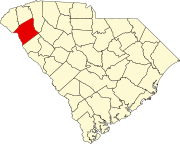
Pickens County is located in the northwest part of the U.S. state of South Carolina. As of the 2020 census, its population was 131,404. Its county seat is Pickens. The county was created in 1826. It is part of the Greenville-Anderson-Greer, SC Metropolitan Statistical Area.

<span class="mw-page-title-main">Greenwood County, South Carolina</span> County in South Carolina, United States

Greenwood County is a county located in the U.S. state of South Carolina. As of the 2020 census, its population was 69,351. Its county seat is Greenwood.

<span class="mw-page-title-main">Anderson County, South Carolina</span> County in South Carolina, United States

Anderson County is a county located in the U.S. state of South Carolina. As of the 2020 census, its population was 203,718. Its county seat is Anderson. Named for Revolutionary War leader Robert Anderson, the county is located in northwestern South Carolina, along the state line of Georgia. Anderson County is included in the Greenville-Anderson-Greer, SC Metropolitan Statistical Area. Anderson County contains 55,950-acre (22,640 ha) Lake Hartwell, a U.S. Army Corps of Engineers lake with nearly 1,000 miles (1,600 km) of shoreline for residential and recreational use. The area is a growing industrial, commercial and tourist center. It is the home of Anderson University, a private, selective comprehensive university of approximately 4,000 undergraduate and graduate students.

<span class="mw-page-title-main">Hartwell, Georgia</span> City in Georgia, United States

Hartwell is a city in Hart County, Georgia, United States. The population was 4,469 at the 2010 census. The city is the county seat of Hart County.

<span class="mw-page-title-main">Jefferson, Georgia</span> City in Georgia, United States

Jefferson is a city and the county seat of Jackson County, Georgia, United States. The population was 9,432 at the 2010 census, up from 3,825 at the 2000 census. As of 2019 the estimated population was 12,032.

<span class="mw-page-title-main">Pendleton, South Carolina</span> Town in South Carolina, United States

Pendleton is a town in Anderson County, South Carolina, United States. The population was 3,489 at the 2020 census. It is a sister city of Stornoway in the Outer Hebrides of Scotland.

<span class="mw-page-title-main">Powdersville, South Carolina</span> CDP in South Carolina, United States

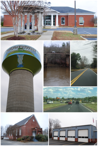
Powdersville is a census-designated place (CDP) in Anderson County, South Carolina. The population was 10,025 at the 2020 census,.

<span class="mw-page-title-main">Williamston, South Carolina</span> Town in South Carolina, United States

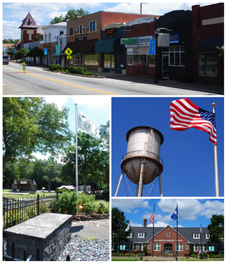
Williamston is a town in Anderson County, South Carolina. The population was 4,043 at the 2020 census.

Duncan is a census-designated place (CDP) in Greenville County, South Carolina, United States. The population was 3,671 at the 2010 census, down from 4,158 in 2000. It is part of the Greenville–Mauldin–Easley Metropolitan Statistical Area.

<span class="mw-page-title-main">Gantt, South Carolina</span> Census-designated place in South Carolina, United States

Gantt is a census-designated place (CDP) in Greenville County, South Carolina, United States. The population was 14,229 at the 2010 census. It is part of the Greenville–Mauldin–Easley Metropolitan Statistical Area and a suburb of the city of Greenville.

Parker is a census-designated place (CDP) in Greenville County, South Carolina, United States. The population was 11,431 at the 2010 census, up from 10,760 in 2000. It is part of the Greenville–Mauldin–Easley Metropolitan Statistical Area.

Wade Hampton is a census-designated place (CDP) in Greenville County, South Carolina, United States. The population was 20,622 at the 2010 census. It is named for American Civil War general and South Carolina governor Wade Hampton.

<span class="mw-page-title-main">Welcome, South Carolina</span> Census-designated place in South Carolina, United States

Welcome is a census-designated place (CDP) in Greenville County, South Carolina, United States. The population was 6,668 at the 2010 census. It is part of the Greenville–Mauldin–Easley Metropolitan Statistical Area. Welcome has been noted for its colorful place name.

<span class="mw-page-title-main">Walhalla, South Carolina</span> City in South Carolina, United States

Walhalla is a city in the foothills of the Blue Ridge Mountains in Oconee County, South Carolina. Designated in 1868 as the county seat, it lies within the area of the Blue Ridge Escarpment, an area of transition between mountains and piedmont, and contains numerous waterfalls. It is located 16 miles (26 km) from Clemson University in Clemson, South Carolina.

<span class="mw-page-title-main">Central, South Carolina</span> Town in South Carolina, United States

Central is a town in Pickens County, South Carolina, United States. As of the 2010 census, the population was 5,159, roughly 3,000 of whom were considered permanent residents. Contrary to its name, it is not near South Carolina's center. It received its name from being halfway or the central point between Atlanta and Charlotte along the former Atlanta and Richmond Air-Line Railway line. Southern Wesleyan University's main campus is east of downtown Central.

<span class="mw-page-title-main">Liberty, South Carolina</span> City in South Carolina, United States

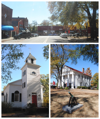
Liberty is a city in Pickens County, South Carolina, United States. It is part of the Greenville–Mauldin–Easley Metropolitan Statistical Area. The city was chartered on March 2, 1876.

<span class="mw-page-title-main">Pickens, South Carolina</span> City in South Carolina, United States

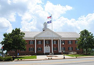
Pickens, formerly called Pickens Courthouse, is a city in and the county seat of Pickens County, South Carolina, United States. The population was 3,126 at the 2010 census. Pickens changed its classification from a town to a city in 1998, but it was not reported to the Census Bureau until 2001. It was named after Andrew Pickens (1739–1817), an American revolutionary soldier and US Congressman for South Carolina.

<span class="mw-page-title-main">Clemson, South Carolina</span> City in South Carolina, United States

Clemson is a city in Pickens and Anderson counties in the U.S. state of South Carolina. Clemson is home to Clemson University; in 2015, the Princeton Review cited the town of Clemson as ranking #1 in the United States for "town-and-gown" relations with its resident university. The population of the city was 17,681 at the 2020 census.

<span class="mw-page-title-main">Piedmont, South Carolina</span> CDP in South Carolina, United States

Piedmont is a census-designated place (CDP) along the Saluda River in Anderson and Greenville counties in the U.S. state of South Carolina. The population was 5,411 at the 2020 census.

Washington District is a former judicial district in South Carolina. It existed as a district from 19 February 1791 to 1 January 1800. The court house and jail for Washington District were in Pickensville, South Carolina.

References

  1. "Your Government Representatives". May 6, 2007. Archived from the original on August 13, 2007. Retrieved May 6, 2007.
  2. "ArcGIS REST Services Directory". United States Census Bureau. Retrieved October 15, 2022.
  3. 1 2 U.S. Geological Survey Geographic Names Information System: Easley, South Carolina
  4. 1 2 "Census Population API". United States Census Bureau. Retrieved October 15, 2022.
  5. "History of Easley". cityofeasley.com. City of Easley.
  6. Owens, Brantli (2008). Images of America: Easley. Arcadia Publishing. pp. 10–11.
  7. "History of Easley, SC". easleychamber.org.
  8. "CURTIS M. TURNER, RACING DRIVER, 46 (Published 1970)". The New York Times. October 6, 1970. ISSN   0362-4331 . Retrieved November 21, 2020.
  9. "US Gazetteer files: 2010, 2000, and 1990". United States Census Bureau. February 12, 2011. Retrieved April 23, 2011.
  10. "Geographic Identifiers: 2010 Demographic Profile Data (G001): Easley city, South Carolina". U.S. Census Bureau, American Factfinder. Archived from the original on February 12, 2020. Retrieved August 7, 2013.
  11. Robertson, Jarvis. "Butch Womack sworn in as new Easley mayor". FOX Carolina. Retrieved November 21, 2020.
  12. "City and Town Population Totals: 2020-2023". United States Census Bureau. May 16, 2024. Retrieved May 16, 2024.
  13. United States Census Bureau. "Census of Population and Housing" . Retrieved November 12, 2013.
  14. "Explore Census Data". data.census.gov. Retrieved December 14, 2021.
  15. "Locations & Hours". Greenville County Library System. Retrieved June 13, 2019.