Spartanburg County | |
---|---|
Coordinates: 34°56′N81°59′W / 34.93°N 81.99°W | |
Country | United States |
State | South Carolina |
Founded | 1791 |
Named for | Spartan Regiment [1] |
Seat | Spartanburg |
Largest community | Spartanburg |
Area | |
• Total | 819.74 sq mi (2,123.1 km2) |
• Land | 808.34 sq mi (2,093.6 km2) |
• Water | 11.40 sq mi (29.5 km2) 1.39% |
Population (2020) | |
• Total | 327,997 |
• Estimate (2023) | 356,698 |
• Density | 405.77/sq mi (156.67/km2) |
Time zone | UTC−5 (Eastern) |
• Summer (DST) | UTC−4 (EDT) |
Congressional districts | 4th, 5th |
Website | www |
Spartanburg County is a county located on the northwestern border of the U.S. state of South Carolina. As of the 2020 census, the population was 327,997, [2] making it the fifth-most populous county in South Carolina. Its county seat is Spartanburg. [3]
Spartanburg County is the largest county within the Spartanburg, SC Metropolitan Statistical Area, which is also included in the Greenville-Spartanburg-Anderson, SC Combined Statistical Area. [4]
The county was founded in 1785 and was named after the Spartan Rifles (Spartan Regiment) which was a local militia during the American Revolutionary War. [1] The largest community and the county seat is Spartanburg, which resides in Upstate South Carolina.
The ship USS Spartanburg County is named after the county.
According to the U.S. Census Bureau, the county has a total area of 819.74 square miles (2,123.1 km2), of which 808.34 square miles (2,093.6 km2) is land and 11.40 square miles (29.5 km2) (1.39%) is water. [5]
Census | Pop. | Note | %± |
---|---|---|---|
1790 | 8,800 | — | |
1800 | 12,122 | 37.8% | |
1810 | 14,259 | 17.6% | |
1820 | 16,989 | 19.1% | |
1830 | 21,150 | 24.5% | |
1840 | 23,669 | 11.9% | |
1850 | 26,400 | 11.5% | |
1860 | 26,919 | 2.0% | |
1870 | 25,784 | −4.2% | |
1880 | 40,409 | 56.7% | |
1890 | 55,385 | 37.1% | |
1900 | 65,560 | 18.4% | |
1910 | 83,465 | 27.3% | |
1920 | 94,265 | 12.9% | |
1930 | 116,323 | 23.4% | |
1940 | 127,733 | 9.8% | |
1950 | 150,349 | 17.7% | |
1960 | 156,830 | 4.3% | |
1970 | 173,724 | 10.8% | |
1980 | 201,861 | 16.2% | |
1990 | 226,800 | 12.4% | |
2000 | 253,791 | 11.9% | |
2010 | 284,307 | 12.0% | |
2020 | 327,997 | 15.4% | |
2023 (est.) | 356,698 | [2] | 8.8% |
U.S. Decennial Census [7] 1790–1960 [8] 1900–1990 [9] 1990–2000 [10] 2010 [11] 2020 [2] |
Race | Num. | Perc. |
---|---|---|
White (non-Hispanic) | 214,440 | 65.38% |
Black or African American (non-Hispanic) | 63,565 | 19.38% |
Native American | 699 | 0.21% |
Asian | 8,176 | 2.49% |
Pacific Islander | 190 | 0.06% |
Other/Mixed | 13,195 | 4.02% |
Hispanic or Latino | 27,732 | 8.45% |
As of the 2020 census, there were 327,997 people, 121,256 households, and 83,432 families residing in the county.
At the 2010 census, there were 284,307 people, 109,246 households, and 75,404 families residing in the county. [13] The population density was 351.9 inhabitants per square mile (135.9/km2). There were 122,628 housing units at an average density of 151.8 per square mile (58.6/km2). [14] The racial makeup of the county was 72.3% white, 20.6% black or African American, 2.0% Asian, 0.3% American Indian, 3.1% from other races, and 1.7% from two or more races. Those of Hispanic or Latino origin made up 5.9% of the population. [13] In terms of ancestry, 13.6% were American, 10.5% were Irish, 9.6% were English, and 8.8% were German. [15]
Of the 109,246 households, 34.3% had children under the age of 18 living with them, 48.9% were married couples living together, 15.1% had a female householder with no husband present, 31.0% were non-families, and 26.2% of all households were made up of individuals. The average household size was 2.53 and the average family size was 3.05. The median age was 38.0 years. [13]
The median income for a household in the county was $42,680 and the median income for a family was $53,149. Males had a median income of $41,445 versus $31,602 for females. The per capita income for the county was $21,924. About 11.0% of families and 14.8% of the population were below the poverty line, including 20.5% of those under age 18 and 10.9% of those age 65 or over. [16]
Year | Republican | Democratic | Third party | |||
---|---|---|---|---|---|---|
No. | % | No. | % | No. | % | |
2020 | 93,560 | 62.94% | 52,926 | 35.60% | 2,169 | 1.46% |
2016 | 76,277 | 62.99% | 39,997 | 33.03% | 4,816 | 3.98% |
2012 | 66,969 | 60.93% | 41,461 | 37.72% | 1,476 | 1.34% |
2008 | 65,042 | 60.04% | 41,632 | 38.43% | 1,654 | 1.53% |
2004 | 62,004 | 64.08% | 33,633 | 34.76% | 1,121 | 1.16% |
2000 | 52,114 | 62.37% | 29,559 | 35.38% | 1,880 | 2.25% |
1996 | 35,972 | 53.53% | 26,814 | 39.90% | 4,410 | 6.56% |
1992 | 37,707 | 51.91% | 25,488 | 35.09% | 9,440 | 13.00% |
1988 | 40,801 | 63.19% | 22,964 | 35.57% | 803 | 1.24% |
1984 | 41,553 | 66.41% | 20,130 | 32.17% | 892 | 1.43% |
1980 | 30,092 | 51.12% | 27,245 | 46.28% | 1,532 | 2.60% |
1976 | 20,456 | 41.99% | 27,925 | 57.32% | 336 | 0.69% |
1972 | 31,308 | 75.34% | 9,586 | 23.07% | 662 | 1.59% |
1968 | 18,183 | 38.69% | 11,467 | 24.40% | 17,346 | 36.91% |
1964 | 18,411 | 47.89% | 20,034 | 52.11% | 0 | 0.00% |
1960 | 10,940 | 35.21% | 20,134 | 64.79% | 0 | 0.00% |
1956 | 6,822 | 26.67% | 16,637 | 65.03% | 2,124 | 8.30% |
1952 | 10,028 | 31.42% | 21,883 | 68.58% | 0 | 0.00% |
1948 | 627 | 5.21% | 6,741 | 55.98% | 4,673 | 38.81% |
1944 | 402 | 4.60% | 8,092 | 92.61% | 244 | 2.79% |
1940 | 248 | 2.65% | 9,119 | 97.35% | 0 | 0.00% |
1936 | 173 | 1.59% | 10,739 | 98.41% | 0 | 0.00% |
1932 | 227 | 2.40% | 9,216 | 97.59% | 1 | 0.01% |
1928 | 760 | 16.45% | 3,859 | 83.53% | 1 | 0.02% |
1920 | 182 | 3.82% | 4,584 | 96.18% | 0 | 0.00% |
1916 | 112 | 2.40% | 4,503 | 96.32% | 60 | 1.28% |
1912 | 37 | 0.96% | 3,616 | 94.07% | 191 | 4.97% |
1908 | 225 | 5.12% | 4,162 | 94.76% | 5 | 0.11% |
1904 | 84 | 3.11% | 2,621 | 96.89% | 0 | 0.00% |
1900 | 101 | 3.93% | 2,467 | 96.07% | 0 | 0.00% |
1896 | 247 | 5.51% | 4,234 | 94.49% | 0 | 0.00% |
1892 | 551 | 13.13% | 3,515 | 83.79% | 129 | 3.08% |
Spartanburg County has long been a Republican stronghold, having not voted for a Democratic presidential nominee since 1976. No Democrat has won 40% of the county’s vote since 1980.
In 2022, the GDP was $19.5 billion (about $54,626 per capita), [18] and the real GDP was $16.7 billion (about $46,895 per capita) in chained 2017 dollars. [19]
As of April 2024 [update] , some of the largest employers in the county include Adidas, BMW, Ingles, Michelin, Optum, QuikTrip, Sage Automotive Interiors, Siemens, and Walmart. [20]
Industry | Employment Counts | Employment Percentage (%) | Average Annual Wage ($) |
---|---|---|---|
Accommodation and Food Services | 13,059 | 8.7 | 21,736 |
Administrative and Support and Waste Management and Remediation Services | 7,800 | 5.2 | 40,300 |
Agriculture, Forestry, Fishing and Hunting | 293 | 0.2 | 41,652 |
Arts, Entertainment, and Recreation | 1,378 | 0.9 | 20,696 |
Construction | 7,245 | 4.8 | 62,868 |
Educational Services | 9,896 | 6.6 | 49,140 |
Finance and Insurance | 2,842 | 1.9 | 73,996 |
Health Care and Social Assistance | 22,105 | 14.7 | 65,104 |
Information | 985 | 0.7 | 68,016 |
Management of Companies and Enterprises | 1,843 | 1.2 | 99,060 |
Manufacturing | 36,291 | 24.1 | 64,896 |
Mining, Quarrying, and Oil and Gas Extraction | 103 | 0.1 | 66,092 |
Other Services (except Public Administration) | 3,353 | 2.2 | 47,944 |
Professional, Scientific, and Technical Services | 4,748 | 3.1 | 71,552 |
Public Administration | 3,821 | 2.5 | 50,752 |
Real Estate and Rental and Leasing | 1,752 | 1.2 | 53,456 |
Retail Trade | 16,410 | 10.9 | 34,424 |
Transportation and Warehousing | 9,011 | 6.0 | 53,872 |
Utilities | 693 | 0.5 | 67,704 |
Wholesale Trade | 7,163 | 4.8 | 64,428 |
Total | 150,791 | 100.0% | 54,303 |
Spartanburg County is served by the Spartanburg County School System, which is divided into seven districts. Some of the districts share a vocational school, and also share the McCarthy Teszler School, a special education school.
South Carolina School for the Deaf and the Blind is in an unincorporated area in the county, near Spartanburg.
Spartanburg Day School, a private school, is in an unincorporated area.
Spartanburg County's healthcare is mainly provided by Spartanburg Regional Healthcare System. Spartanburg Regional is a public, not-for-profit, integrated health care delivery system with several facilities in Spartanburg, including:
In early 2018, Spartanburg Regional began construction on an expansion of its Gibbs Cancer Center & Research Institute at Pelham location. The 191,000-square-foot (17,700 m2) expansion is intended to provide cancer care for more patients along the border of Spartanburg and Greenville counties. The expansion of the building was completed and began accepting patients in March 2020. [33] [34]
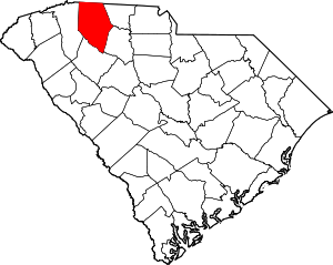
Cherokee County is a county in the U.S. state of South Carolina. As of the 2020 census, the population was 56,216. The county seat is Gaffney. The county was formed in 1897 from parts of York, Union, and Spartanburg counties. It was named for the Cherokee people who historically occupied this area prior to European encounter.
Gaffney is a city in and the seat of Cherokee County, South Carolina, United States, in the Upstate region of South Carolina. Gaffney is known as the "Peach Capital of South Carolina". The population was 12,539 at the 2010 census, with an estimated population of 12,609 in 2019. It is the principal city of the Gaffney, South Carolina, Micropolitan Statistical Area, which includes all of Cherokee County and which is further included in the greater Greenville-Spartanburg-Anderson, South Carolina Combined Statistical Area.
Five Forks is a census-designated place (CDP) in Greenville County, South Carolina, United States. The population was 17,737 at the 2020 census, up from 14,140 in 2010, and 8,064 in 2000. It is a growing, affluent suburb of Greenville and is part of the Greenville–Mauldin–Easley Metropolitan Statistical Area.
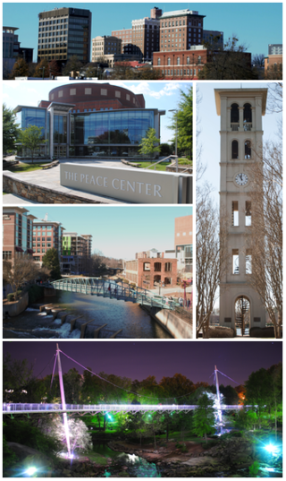
Greenville is a city in and the county seat of Greenville County, South Carolina, United States. With a population of 70,720 at the 2020 census, it is the 6th-most populous city in the state. Greenville is located approximately halfway between Atlanta, Georgia, and Charlotte, North Carolina, along Interstate 85. Its metropolitan area also includes Interstates 185 and 385. Greenville is the anchor city of the Upstate, a combined statistical area with an estimated population of 1,590,636 in 2023. Greenville was the fourth fastest-growing city in the United States between 2015 and 2016, according to the U.S. Census Bureau.
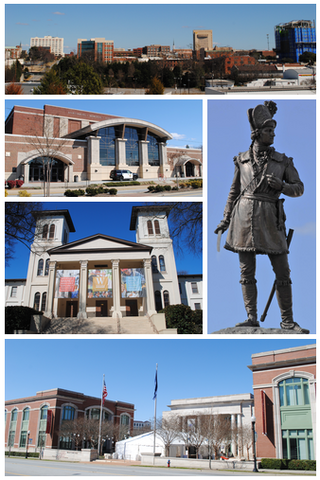
Spartanburg is a city in and the seat of Spartanburg County, South Carolina, United States. The city had a population of 38,732 as of the 2020 census, making it the 11th-most populous city in the state. For a time, the Office of Management and Budget (OMB) grouped Spartanburg and Union counties together as the Spartanburg, SC Metropolitan Statistical Area, but the OMB now defines the Spartanburg, SC MSA as only Spartanburg County.
Woodruff is a city in Spartanburg County, South Carolina, United States, located in upstate South Carolina. The population was 4,333 at the 2020 census.
Chesnee is a city in Spartanburg and Cherokee counties, in the U.S. state of South Carolina. The population was 868 as of the 2010 census.
Greer is a city in Greenville and Spartanburg counties in the U.S. state of South Carolina. The population was 35,308 as of the 2020 census, making it the 14th-most populous city in South Carolina. Greer is included in the Greenville-Anderson-Greer, SC Metropolitan Statistical Area, which is part of the Greenville-Spartanburg-Anderson, SC Combined Statistical Area in Upstate South Carolina.
U.S. Route 176 is a spur of US 76 in the U.S. states of North Carolina and South Carolina. The U.S. Highway runs 237.98 miles (382.99 km) from US 25 Business and North Carolina Highway 225 in Hendersonville, North Carolina, east to US 52 in Goose Creek, South Carolina. US 176 serves the transition region between the Blue Ridge Mountains and Foothills of Western North Carolina and the Upstate, Midlands, and Lowcountry regions of South Carolina. The highway passes through and connects Spartanburg, one of two major cities in the Upstate, and Columbia, the South Carolina state capital and central city of the Midlands. US 176 parallels and serves as a secondary highway to Interstate 26 (I-26) except for between Spartanburg and Columbia, where the U.S. Highway deviates from the I-26 corridor to serve Union.
Greenville County School District (GCSD) is a public school district in Greenville County, South Carolina (USA). It is the largest school district in the state of South Carolina and the 44th largest in the US. As of the 2019–2020 school year, the district, led by Superintendent Dr. W Burke Royster, serves 76,964 students from Greenville; and some parts of Laurens and Spartanburg counties. Spread across 106 education centers, the district currently employs 4,908 certified teachers. GCSD has an operating budget of $592.639 million for the 2017–2018 school year. GCSD has 14 National Blue Ribbon Schools, 9 Newsweek's Best High Schools, 21 Carolina First Palmetto's Finest Schools, 48 Red Carpet Schools, and 29 National PTA Schools of Excellence.
Spartanburg Regional Healthcare System(SRHS) is one of South Carolina's largest healthcare systems. SRHS draws patients primarily from the areas of Spartanburg, Cherokee, Union, and Greenville counties (all located in the Piedmont region of South Carolina) as well as Rutherford and Polk counties (located in western North Carolina). Spartanburg General Hospital was organized under the authority of the South Carolina General Assembly in 1917 and officially became the Spartanburg Regional Health Services District, Inc., a political subdivision of the State of South Carolina, by the charter granted by the secretary of state of South Carolina on May 1, 1995.
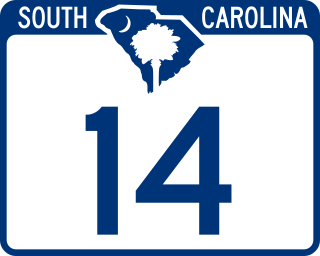
South Carolina Highway 14 is a state highway in the U.S. state of South Carolina. The state highway runs 59.24 miles (95.34 km) from U.S. Route 76 Business in Laurens north to Interstate 26 (I-26) in Landrum. SC 14 connects Laurens and Landrum with Greer, the city between Greenville and Spartanburg where the highway crosses I-85 and US 29. The highway also parallels I-385 through Fountain Inn and Simpsonville, South Carolina in southeastern Greenville County. SC 14 is a part of the National Highway System between I-85 and US 29 in Greer.
In the U.S. state of South Carolina, U.S. Route 221 (US 221) is a 126.390-mile United States Highway within the state. It is part of the United States Numbered Highway System that travels from Perry in North Florida to Lynchburg in Central Virginia. While in South Carolina, the highway travels through Greenwood, Laurens, Woodruff, and Spartanburg. The highway mostly travels through rural parts of the Piedmont region of the state.
Spartanburg County School District 2 is a public school district in Spartanburg County, South Carolina, US. The district is led by superintendent Lance Radford and consists of fourteen schools. The district also has a maintenance and transportation department to serve the students and staff. Students in the district have access to the Swofford Career Center, a vocational school shared with Spartanburg County School District 1.
Fairforest is a Census-designated place located in Spartanburg County in the U.S. State of South Carolina. According to the 2010 United States Census, the population was 1,646.
Spartanburg County School District 3(SCSD3) is a public school district in Spartanburg County, South Carolina, United States. Led by superintendent Kenny Blackwood, the district operates seven schools and the Daniel Morgan Technology Center.
Spartanburg County School District 6(SCSD6) is a public school district in Spartanburg County, South Carolina, US. Led by superintendent Ken Kiser, the district operates thirteen schools.
Camp Croft is an unincorporated area and census-designated place (CDP) in Spartanburg County, South Carolina, United States. It was first listed as a CDP prior to the 2020 census. The 2020 census lists a population of 2,110.
Whitney is an unincorporated area and census-designated place (CDP) adjacent to the city of Spartanburg in Spartanburg County, South Carolina, United States. It was first listed as a CDP prior to the 2020 census with a population of 4,409.