
Spartanburg County is a county located on the northwestern border of the U.S. state of South Carolina. As of the 2020 census, the population was 327,997, making it the fifth-most populous county in South Carolina. Its county seat is Spartanburg.

Greenville County is located in the U.S. state of South Carolina. As of the 2020 census, the population was 525,534, making it the most populous county in the state. Its county seat is Greenville. The county is also home to the Greenville County School District, the largest school system in South Carolina.

Gaffney is a city in and the seat of Cherokee County, South Carolina, United States, in the Upstate region of South Carolina. Gaffney is known as the "Peach Capital of South Carolina". The population was 12,539 at the 2010 census, with an estimated population of 12,609 in 2019. It is the principal city of the Gaffney, South Carolina, Micropolitan Statistical Area, which includes all of Cherokee County and which is further included in the greater Greenville-Spartanburg-Anderson, South Carolina Combined Statistical Area.
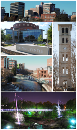
Greenville is a city in and the county seat of Greenville County, South Carolina, United States. With a population of 70,720 at the 2020 census, it is the 6th-most populous city in the state. Greenville is located approximately halfway between Atlanta, Georgia, and Charlotte, North Carolina, along Interstate 85. Its metropolitan area also includes Interstates 185 and 385. Greenville is the anchor city of the Upstate, a combined statistical area with an estimated population of 1,590,636 in 2023. Greenville was the fourth fastest-growing city in the United States between 2015 and 2016, according to the U.S. Census Bureau.

Cayce is a city in the U.S. state of South Carolina, along the Congaree River. The population was 12,528 at the 2010 census and rose to 13,789 in the 2020 United States Census, and it is the third-most populated municipality in Lexington County. The city is primarily in Lexington County, with additional, predominantly rural land to the east in Richland County. Cayce is part of the Columbia Metropolitan Statistical Area and is within South Carolina's Midlands region.
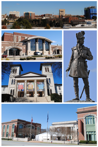
Spartanburg is a city in and the seat of Spartanburg County, South Carolina, United States. The city had a population of 38,732 as of the 2020 census, making it the 11th-most populous city in the state. For a time, the Office of Management and Budget (OMB) grouped Spartanburg and Union counties together as the Spartanburg, SC Metropolitan Statistical Area, but the OMB now defines the Spartanburg, SC MSA as only Spartanburg County.

Greer is a city in Greenville and Spartanburg counties in the U.S. state of South Carolina. The population was 35,308 as of the 2020 census, making it the 14th-most populous city in South Carolina. Greer is included in the Greenville-Anderson-Greer, SC Metropolitan Statistical Area, which is part of the Greenville-Spartanburg-Anderson, SC Combined Statistical Area in Upstate South Carolina.
Gorges State Park is a 7,709-acre (31.20 km2) North Carolina state park in Transylvania County, North Carolina in the United States and along with other conservation lands is part of a 100,000+ acre conservation corridor stretching some 80 miles along the NC/SC state line. The land, along Jocassee Gorges, was purchased by the state from Duke Energy Corporation in 1999. It is North Carolina's westernmost state park and one of the state's newest. The park is adjacent to part of the Pisgah National Forest and the N.C. Wildlife Resources Commission's Toxaway Game Land. Gorges State Park provides the principal access to the Horsepasture River on these adjoining public lands.

Jones Lake State Park is a North Carolina state park in Bladen County, North Carolina in the United States near Elizabethtown. It covers 2,208-acre (8.94 km2), including the Carolina bay lakes of Jones Lake and Salters Lake. Jones Lake State Park is north of Elizabethtown on North Carolina Highway 242 in North Carolina's Coastal Plain region. The park offers year-round recreation, including fishing, swimming, boating, hiking, picnicking and environmental and historical education programs.

William B. Umstead State Park is a North Carolina state park in Wake County, North Carolina in the United States. It covers 5,599 acres (22.66 km2) nestled between the expanding cities of Raleigh, Cary, and Durham, North Carolina. It offers hiking, bridle, and bike trails, boat rentals, camping, picnic areas, and educational programs.

The Upstate, historically known as the Upcountry, is a region of the U.S. state of South Carolina, comprising the northwesternmost area of the state. Although loosely defined among locals, the general definition includes the 10 counties of the commerce-rich I-85 corridor in the northwest corner of South Carolina. This definition coincided with the Greenville-Spartanburg-Anderson, SC Combined Statistical Area, as first defined by the Office of Management and Budget (OMB) in 2015. In 2023, the OMB issued its most updated definition of the CSA that coincides again with the 10-county region.

Codorus State Park is a 3,500-acre (1,400 ha) Pennsylvania state park in Heidelberg, Manheim, Penn, and West Manheim Townships in southwestern York County, Pennsylvania in the United States. The park was created around Lake Marburg, an artificial lake covering 1,275 acres (516 ha), and is named for Codorus Creek, which forms the lake. Codorus State Park is located on Pennsylvania Route 216, 3 miles (4.8 km) from the borough of Hanover.
Fort Custer State Recreation Area is a 3,033-acre (12 km2) State Recreation Area located between Battle Creek and Kalamazoo, Michigan. The area features lakes, the Kalamazoo River, over 25 miles of multi-use trails, second growth oak barrens and dry-mesic southern (oak-hickory) forests.

The South Carolina Army National Guard is a component of the United States Army and the United States National Guard. Nationwide, the Army National Guard comprises approximately one half of the U.S. Army's available combat forces and approximately one third of its support organization. National coordination of various state National Guard units is maintained through the National Guard Bureau.

Table Rock State Park is a 3,083-acre (12.48 km2) park at the edge of the Blue Ridge Mountains in northern Pickens County, South Carolina. The park includes Pinnacle Mountain, the tallest mountain totally within the state.
Santee State Park is in the Sandhills of South Carolina on the western edge of the 110,000-acre (445 km2) Lake Marion. It is located off SC 6, three miles (5 km) northwest of the town of Santee and I-95.

Paris Mountain State Park is a state park in the U.S. state of South Carolina, located five miles (8 km) north of Greenville. Activities available in the 1,540-acre (6 km2) park include hiking, biking, swimming and picnicking. The 13-acre (52,609 m2) Lake Placid offers swimming and fishing. Canoes, kayaks, and pedal boats are seasonally available for rental; private boats are not permitted. Camping is allowed and campsites range from rustic, back country sites to paved sites with water and electricity hook-ups. The park's Civilian Conservation Corps (CCC) structures, including the Camp Buckhorn lodge, are listed on the National Register of Historic Places. m.

The Prisma Health Swamp Rabbit Trail is a 19.9-mile (32.0 km) multi-use rail trail in Greenville County, South Carolina, that largely follows the bed of a former railroad that had been nicknamed after the indigenous swamp rabbit. South-to-north the current trail begins at Greenville Technical College, crosses the city of Greenville, proceeds through Falls Park and the campus of Furman University, and ends about a mile north of the Travelers Rest city limits.

Camp Wadsworth was a World War I-era training facility for the United States Army. Located near Spartanburg, South Carolina, the post was in operation from its opening in July 1917 until it was inactivated in March 1919, following the Armistice that ended the war.
Camp Croft is an unincorporated area and census-designated place (CDP) in Spartanburg County, South Carolina, United States. It was first listed as a CDP prior to the 2020 census. The 2020 census lists a population of 2,110.

