
Lake Michigan is one of the five Great Lakes of North America. It is the second-largest of the Great Lakes by volume and the third-largest by surface area, after Lake Superior and Lake Huron. To the east, its basin is conjoined with that of Lake Huron through the 3+1⁄2 miles wide, 295 feet deep, Straits of Mackinac, giving it the same surface elevation as its easterly counterpart; the two are technically a single lake.

Dillon County is a county located in the U.S. state of South Carolina. As of the 2020 census, the county's population was 28,292, down from 32,062 in 2010. The county seat is Dillon.
Carolina bays are elliptical to circular depressions concentrated along the Atlantic seaboard within coastal New York, New Jersey, Delaware, Maryland, Virginia, North Carolina, South Carolina, Georgia, and north Florida. In Maryland, they are called Maryland basins. Within the Delmarva Peninsula, they and other coastal ponds are also called Delmarva bays.
Fair Haven Beach State Park is a 1,141-acre (4.62 km2) state park on the southeastern shore of Lake Ontario in upstate New York. It is located on the east side of Little Sodus Bay in the town of Sterling in Cayuga County, northeast of the village of Fair Haven. The southern part of the park is sometimes called Fair Haven State Park.

Jones Lake State Park is a North Carolina state park in Bladen County, North Carolina in the United States near Elizabethtown. It covers 2,208-acre (8.94 km2), including the Carolina bay lakes of Jones Lake and Salters Lake. Jones Lake State Park is north of Elizabethtown on North Carolina Highway 242 in North Carolina's Coastal Plain region. The park offers year-round recreation, including fishing, swimming, boating, hiking, picnicking and environmental and historical education programs.

Lake Waccamaw State Park is a North Carolina state park in Columbus County, North Carolina, in the United States. Located near the town of Lake Waccamaw, North Carolina, it covers 2,398-acre (9.70 km2), along the shores of Lake Waccamaw, a Carolina bay. Recent work by the U.S. Geological Survey has interpreted the Carolina Bays as relict thermokarst lakes that formed several thousands of years ago when the climate was colder, drier, and windier. Thermokarst lakes develop by thawing of frozen ground (permafrost) and by subsequent modification by wind and water. Thus, this interpretation suggests that permafrost once extended as far south as the Carolina Bays during the last ice age and (or) previous ice ages.

Pettigrew State Park is a North Carolina State Park in Tyrrell and Washington Counties, North Carolina in the United States. It covers 5,951 acres (24.08 km2) around the shore lines of Lake Phelps and the Scuppernong River. The park's developed facilities are south of U.S. Route 64 near Roper and Creswell, North Carolina. Pettigrew State Park is open for year-round recreation, including hiking, camping, fishing, boating and picnicking.

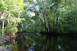
Singletary Lake State Park is a North Carolina state park in Bladen County, North Carolina in the United States. Located near Elizabethtown, it covers 1,221 acres (4.94 km2), including Singletary Lake, one of the largest Carolina bays. Singletary Lake State Park is southeast of Elizabethtown on North Carolina Highway 53 in North Carolina's Coastal Plain region. It serves primarily as a group camp but is open on a limited basis for year-round recreation, including hiking, fishing and observing nature.

Lake Waccamaw is a fresh water lake located in Columbus County in North Carolina. It is the largest of the natural Carolina Bay lakes. Although bay trees are present within many Carolina Bays, the term "bay" does not refer to the trees but comes instead from an early science publication by Glenn (1895), who used the word "bay" to refer to these features near the town of Darlington, South Carolina. Lake Waccamaw is fed by four creeks: First, Second, Third, and Big creeks. The outlet forms the Waccamaw River which flows southeasterly to empty into the Atlantic Ocean near Georgetown, South Carolina
The Little Pee Dee River is a 116-mile-long (187 km) tributary of the Pee Dee River. The Little Pee Dee technically arises near Laurinburg, North Carolina as Gum Swamp, which flows southward, receiving several small tributaries, across the South Carolina border into Red Bluff Lake, near McColl, South Carolina. The lake is at an elevation of 135 feet (41 m) above sea level, and from the outlet of the lake, the flow is called the Little Pee Dee River. The Little Pee Dee River is named after the Pee Dee Indian Tribe. In fact, today the tribe still occupies some of their ancestral lands, although the tribe only consists of just over 200 enrolled members.
The Pee Dee is a region in the northeast corner of the U.S. state of South Carolina. It lies along the lower watershed of the Pee Dee River, which was named after the Pee Dee Native Tribe, a state-recognized tribe of approximately 200 members.

The Sandhills or Carolina Sandhills is a 10-35 mi wide physiographic region within the U.S. Atlantic Coastal Plain province, along the updip (inland) margin of this province in the States of North Carolina, South Carolina, and Georgia. The extent of the Carolina Sandhills is shown clearly in maps of the ecoregions of North Carolina, South Carolina, and Georgia.
Lake Phelps is North Carolina's second largest natural lake. It has a surface area of 16,600 acres (67 km2), and it is located primarily in Washington County on the Albemarle-Pamlico Peninsula between the Albemarle Sound and the Pamlico Sound. The easternmost part of the lake extends into Tyrrell County.

The Lumber River, sometimes referred to as the Lumbee River, is a 133-mile-long (214 km) river in south-central North Carolina in the flat Coastal Plain. European settlers first called the river Drowning Creek, which is the name of its headwater. The waterway known as the Lumber River extends downstream from the Scotland County-Hoke County border to the North Carolina-South Carolina border. Soon after crossing into South Carolina, the Lumber River flows into the Little Pee Dee River, which flows into the Pee Dee River, or Great Pee Dee River. Finally, the combined waters flow into Winyah Bay and the Atlantic Ocean.
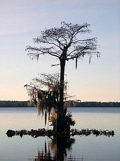
Singletary Lake, surrounded by Singletary Lake State Park in Bladen County, North Carolina in the United States, is one of a series of Carolina bay lakes that stretch from New Jersey to Florida along the Atlantic Coastal Plain. Recent work by the U.S. Geological Survey has interpreted the Carolina Bays as relict thermokarst lakes that formed several thousands of years ago when the climate was colder, drier, and windier. Thermokarst lakes develop by thawing of frozen ground (permafrost) and by subsequent modification by wind and water. Thus, this interpretation suggests that permafrost once extended as far south as the Carolina Bays during the last ice age and (or) previous ice ages. Singletary Lake is not fed by any stream, but relies entirely upon rain. The land beneath and surrounding the lake is mica-rich sandy clay and sand that is from the Upper Cretaceous era with a thin layer of Pleistocene deposits covering it. This land is lower than the surrounding land and drains very poorly, creating Singletary Lake.
Candle Lake is a reservoir in the central part of the Canadian province of Saskatchewan in the boreal forest, approximately 80 kilometres (50 mi) north-east of Prince Albert. A dam completed in 1979 at the southern end of the lake regulates water levels; several small creeks feed into the lake and Torch River flows out of the lake at the dam. Candle Lake Provincial Park surrounds most of the lake and the resort village of Candle Lake is at the southern end.

Woods Bay State Park is a state park located near the town of Olanta in Florence County, South Carolina. The park contains some of the last remaining large Carolina Bays. Recent work by the U.S. Geological Survey has interpreted the Carolina Bays as relict thermokarst lakes that formed several thousands of years ago when the climate was colder, drier, and windier. Thermokarst lakes develop by thawing of frozen ground (permafrost) and by subsequent modification by wind and water. Thus, this interpretation suggests that permafrost once extended as far south as the Carolina Bays during the last ice age and (or) previous ice ages.
Lewis Ocean Bay Heritage Preserve is a 10,427-acre natural preserve near Carolina Forest, South Carolina.
Good Spirit Lake Provincial Park is a provincial park on the eastern side of the Canadian province of Saskatchewan. Founded in 1931, the park surrounds the western and southern shores of Good Spirit Lake and is one of Saskatchewan's six founding provincial parks. The park is in the RM of Good Lake No. 274, 48 km (30 mi) north of the city of Yorkton. Highway 47 runs along the western boundary and Highway 229 provides access to the park's amenities.
Candle Lake Provincial Park is a provincial park in the central region of the Canadian province of Saskatchewan. Prior to the park's establishment in 1986, it was a provincial recreation site. Located in the Rural Municipality of Paddockwood No. 520, Candle Lake Provincial Park surrounds most of Candle and Torch Lakes in the boreal forest ecozone of Canada. The park has a variety of activities including camping, boating, fishing, swimming, mini golfing, hiking, and golfing. Around the lake there are also boat launches and several marinas. Natural attractions include a purple sand beach, sand dunes, mature forests, crystal clear lake water, and several natural sand beaches.

